It looks like you're using an Ad Blocker.
Please white-list or disable AboveTopSecret.com in your ad-blocking tool.
Thank you.
Some features of ATS will be disabled while you continue to use an ad-blocker.

California going off!
page: 2share:
reply to post by hollwd
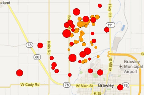
I was zooming in on the detail map on one in Brawley. What exactly is that when you zoom in? It almost looks like concrete surrounded by grass lands. Is it a bridge, road? I cant figure it out.
quakes.globalincidentmap.com...
I was zooming in on the detail map on one in Brawley. What exactly is that when you zoom in? It almost looks like concrete surrounded by grass lands. Is it a bridge, road? I cant figure it out.
quakes.globalincidentmap.com...
reply to post by Wrabbit2000
I have a sidebar EQ app.. it shows all the EQs everywhere on my desktop.. There is always some in CA.. but mostly 1.0 to 2.0 maybe
I have a sidebar EQ app.. it shows all the EQs everywhere on my desktop.. There is always some in CA.. but mostly 1.0 to 2.0 maybe
Forgive the ignorance, but how strong must it be in order to be felt? To do structural damage?
Kinda puts it into perspective:
Less than an hour later:
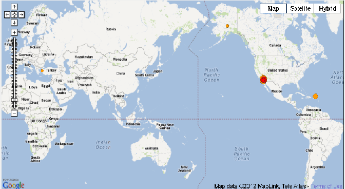
What I find interesting is that the Global incident map site: quakes.globalincidentmap.com... has a 17 hr duration for quakes to remain on the map. But here, the bigger ones within the last 2 hours are being removed. Not only that but there are no other quakes on the map anywhere in the World except small ones in Puerto Rico, Turkey and Alaska.
hmmmm?
Peace
Less than an hour later:
What I find interesting is that the Global incident map site: quakes.globalincidentmap.com... has a 17 hr duration for quakes to remain on the map. But here, the bigger ones within the last 2 hours are being removed. Not only that but there are no other quakes on the map anywhere in the World except small ones in Puerto Rico, Turkey and Alaska.
hmmmm?
Peace
edit on 26-8-2012 by jude11 because: (no reason given)
reply to post by riverwild
Brawley is in the middle of the desert.. It is TOWN with irrigation fields all around it.. Nothing would grow if they did not pull water up from the ground. No running water really except what they get from the Colorado River.. and the rivers from Mexico that dump into the Salton Sea.. Nasty rivers.. you do not even want to eat the fish from that one. The all america canal brings us water...it is concrete..
Brawley is in the middle of the desert.. It is TOWN with irrigation fields all around it.. Nothing would grow if they did not pull water up from the ground. No running water really except what they get from the Colorado River.. and the rivers from Mexico that dump into the Salton Sea.. Nasty rivers.. you do not even want to eat the fish from that one. The all america canal brings us water...it is concrete..
reply to post by hollwd
Indeed.... I grew up in Cali and most of my family is within 100 miles of this swarm. It's normal to have quakes there every day at low levels. 365/days a year. No doubt...but I've never had page after page after page of a continuous swarm to look at before. This is odd..... I hope the trend down ATM is it settling down and ending.
Indeed.... I grew up in Cali and most of my family is within 100 miles of this swarm. It's normal to have quakes there every day at low levels. 365/days a year. No doubt...but I've never had page after page after page of a continuous swarm to look at before. This is odd..... I hope the trend down ATM is it settling down and ending.
reply to post by hollwd
I checked on the internet, that area had a 7.1 back in 1940. The swarming is what is weird. The southeastern desert area that is a "one and done" area (more or less), as you said.
earthquake.usgs.gov...
Wasn't there a swarm of Cali quakes a few weeks ago, which precipitated a large quake in Iran?
The earth is waking up, for sure. It's not a heavily-populated area, thank goodness, and this may not mean anything, but it is pretty unusual as far as frequency. The rest of the world is relatively quiet as well. Strange harbinger of......?
reply to post by smyleegrl
Just a ball park figure....
Probably like a 7ish. But even then, California has adopted strict seismic safeguards in the construction sector. Only old buildings would be damaged.
Just a ball park figure....
Probably like a 7ish. But even then, California has adopted strict seismic safeguards in the construction sector. Only old buildings would be damaged.
Originally posted by hollwd
reply to post by deadeyedick
also more in Iran.
I dont see that any hit Iran. What site do you follow?
Apprears to very few anyplace else from the map I'm looking at. A small one in Turkey but that about it.
reply to post by smyleegrl
From what i know its the magnitude plus the depth that matters.
If it is shallow and high in magnitude then hold on if its deep and high magnitude then not so bad.
From what i know its the magnitude plus the depth that matters.
If it is shallow and high in magnitude then hold on if its deep and high magnitude then not so bad.
Earthquake "Booms" being heard?
sacramento.cbslocal.com...
EL DORADO COUNTY (CBS13) – People from all over El Dorado County say they’re hearing loud booms several times a week, but there are many theories on what is causing them.
sacramento.cbslocal.com...
Source
reply to post by smyleegrl
How big does it need to be for a person to feel it? What an earthquake feels like depends on many factors: the magnitude, your distance from the hypocenter (considering the depth of the quake), the type of soil or rock you are on, the building you are in or if you are outdoors & what you are doing at the time. Under ideal conditions, you are lying or sitting still in an upper floor, right on top of a shallow earthquake, you might feel a 1.8 if you were paying attention. Usually, however, it takes at least a magnitude of 2.0 for multiple people to notice a quake & recognize it as a quake. A 4.0 usually gets a lot of public attention if it happens under a populated area.
How big does in need to be to cause damage? The damage potential of an earthquake also depends on several factors: the magnitude, your distance from the fault rupture (not necessarily the epicenter), directivity effects, soil or rock type, type, age & quality of building construction & various geologic “special cases”. Directivity is a phenomenon related to the direction the fault rupture is propagating. If it is propagating toward you, the seismic waves are stronger & the damage potential greater than the case where it is propagating away from you, even at the same distance from the fault rupture. In general, soft sediment amplifies ground motion, so damage is likely to be worse in geographic basins, as opposed to on rocky mountains or hills at the same distance from the fault rupture. Besides magnitude, however, the most significant factor in damage is the construction of the building itself. Unreinforced masonry (URM) or adobe is by far the worst, since the materials are heavy & weak. Reinforced masonry or “retrofitted” URM buildings are somewhat better, but still may be dangerous. The best is properly built one or two story wood frame construction, anchored to the foundation & with plywood shear walls. Steel frame structures & reinforced concrete structures are usually also resistant to earthquake damage, with age & overall design being a factor.
edit on 8/26/2012 by iforget because: (no reason given)
reply to post by minettejo
No thank god.. I live in Missouri now.. but I will call a cousin and ask how it feels.. she lives in El Centro.. right down the road..
No thank god.. I live in Missouri now.. but I will call a cousin and ask how it feels.. she lives in El Centro.. right down the road..
Hello people, I am really routing for you people in Cal tonight, because with Vulcanos and E Qs it is not a good place to be, I have been watching
Earthquakes on my PC since Jan 2012 with a bit of software, here is my list of quakes today I know about.
Update time = Sun Aug 26 20:17:23 UTC 2012
MAG UTC DATE-TIME
y/m/d h:m:s LAT
deg LON
deg DEPTH
km Region
MAP 3.0 2012/08/26 20:14:46 32.996 -115.582 12.5 SOUTHERN CALIFORNIA
MAP 2.6 2012/08/26 20:10:14 33.000 -115.561 11.1 SOUTHERN CALIFORNIA
MAP 2.5 2012/08/26 20:08:32 32.928 -115.577 7.9 SOUTHERN CALIFORNIA
MAP 2.9 2012/08/26 20:06:08 32.934 -115.457 3.5 SOUTHERN CALIFORNIA
MAP 2.5 2012/08/26 20:04:50 33.008 -115.559 9.6 SOUTHERN CALIFORNIA
MAP 3.6 2012/08/26 19:58:17 33.025 -115.541 13.6 SOUTHERN CALIFORNIA
MAP 3.5 2012/08/26 19:58:01 33.108 -115.525 0.2 SOUTHERN CALIFORNIA
MAP 2.8 2012/08/26 19:57:34 33.010 -115.541 9.8 SOUTHERN CALIFORNIA
MAP 3.4 2012/08/26 19:50:15 33.007 -115.586 12.8 SOUTHERN CALIFORNIA
MAP 2.8 2012/08/26 19:48:04 33.021 -115.558 24.8 SOUTHERN CALIFORNIA
MAP 2.5 2012/08/26 19:47:08 32.989 -115.572 12.4 SOUTHERN CALIFORNIA
MAP 3.2 2012/08/26 19:45:56 32.993 -115.575 0.2 SOUTHERN CALIFORNIA
MAP 3.5 2012/08/26 19:44:57 32.806 -115.491 4.5 SOUTHERN CALIFORNIA
MAP 3.3 2012/08/26 19:43:41 33.018 -115.530 9.1 SOUTHERN CALIFORNIA
MAP 4.3 2012/08/26 19:40:13 32.988 -115.604 10.2 SOUTHERN CALIFORNIA
MAP 4.1 2012/08/26 19:39:30 33.001 -115.550 15.5 SOUTHERN CALIFORNIA
MAP 3.1 2012/08/26 19:38:48 32.989 -115.543 10.2 SOUTHERN CALIFORNIA
MAP 3.7 2012/08/26 19:35:51 32.977 -115.519 4.2 SOUTHERN CALIFORNIA
MAP 4.9 2012/08/26 19:33:01 32.998 -115.559 3.1 SOUTHERN CALIFORNIA
MAP 5.3 2012/08/26 19:31:23 33.016 -115.564 9.4 SOUTHERN CALIFORNIA
MAP 2.6 2012/08/26 19:30:55 33.035 -115.536 10.2 SOUTHERN CALIFORNIA
MAP 3.7 2012/08/26 19:30:28 32.988 -115.535 1.8 SOUTHERN CALIFORNIA
MAP 3.4 2012/08/26 19:28:45 33.023 -115.561 13.7 SOUTHERN CALIFORNIA
MAP 3.4 2012/08/26 19:28:36 33.021 -115.564 12.5 SOUTHERN CALIFORNIA
MAP 3.5 2012/08/26 19:21:04 33.003 -115.546 11.0 SOUTHERN CALIFORNIA
MAP 4.6 2012/08/26 19:20:05 33.019 -115.545 13.1 SOUTHERN CALIFORNIA
MAP 4.0 2012/08/26 19:16:12 33.026 -115.547 13.8 SOUTHERN CALIFORNIA
MAP 2.5 2012/08/26 19:06:48 33.024 -115.541 13.4 SOUTHERN CALIFORNIA
MAP 2.5 2012/08/26 19:06:32 33.027 -115.542 13.3 SOUTHERN CALIFORNIA
MAP 3.0 2012/08/26 19:03:19 33.027 -115.538 14.5 SOUTHERN CALIFORNIA
MAP 3.1 2012/08/26 18:58:12 33.024 -115.546 13.5 SOUTHERN CALIFORNIA
MAP 2.6 2012/08/26 18:55:55 33.008 -115.560 12.2 SOUTHERN CALIFORNIA
MAP 3.5 2012/08/26 18:32:55 19.537 -64.491 16.0 VIRGIN ISLANDS REGION
MAP 2.7 2012/08/26 18:11:24 33.014 -115.560 12.7 SOUTHERN CALIFORNIA
MAP 2.6 2012/08/26 17:37:16 33.011 -115.551 12.0 SOUTHERN CALIFORNIA
MAP 3.4 2012/08/26 17:30:42 19.595 -64.374 16.0 VIRGIN ISLANDS REGION
MAP 2.6 2012/08/26 17:18:13 33.010 -115.556 12.2 SOUTHERN CALIFORNIA
MAP 2.5 2012/08/26 17:17:23 33.017 -115.556 12.2 SOUTHERN CALIFORNIA
MAP 3.3 2012/08/26 17:16:02 33.023 -115.549 13.4 SOUTHERN CALIFORNIA
MAP 2.9 2012/08/26 17:13:52 33.017 -115.555 12.7 SOUTHERN CALIFORNIA
MAP 2.6 2012/08/26 17:03:40 32.996 -115.548 6.0 SOUTHERN CALIFORNIA
MAP 3.9 2012/08/26 17:02:13 33.022 -115.552 14.2 SOUTHERN CALIFORNIA
MAP 3.0 2012/08/26 16:45:42 59.587 -153.405 100.0 SOUTHERN ALASKA
MAP 2.5 2012/08/26 16:18:16 33.018 -115.555 12.4 SOUTHERN CALIFORNIA
MAP 2.8 2012/08/26 16:14:51 59.977 -152.290 60.5 SOUTHERN ALASKA
MAP 2.5 2012/08/26 15:48:24 32.998 -115.559 11.4 SOUTHERN CALIFORNIA
MAP 2.5 2012/08/26 15:48:11 33.010 -115.548 12.0 SOUTHERN CALIFORNIA
MAP 2.5 2012/08/26 15:33:04 33.015 -115.552 12.5 SOUTHERN CALIFORNIA
MAP 6.6 2012/08/26 15:05:37 2.197 126.835 91.9 MOLUCCA SEA
MAP 2.9 2012/08/26 15:00:15 19.634 -64.040 71.0 VIRGIN ISLANDS REGION
MAP 2.8 2012/08/26 14:42:11 19.420 -63.968 95.0 VIRGIN ISLANDS REGION
MAP 4.1 2012/08/26 14:37:51 19.660 -64.264 32.0 VIRGIN ISLANDS REGION
MAP 4.4 2012/08/26 14:30:30 37.077 142.533 36.3 OFF THE EAST COAST OF HONSHU, JAPAN
MAP 2.6 2012/08/26 14:00:24 35.640 -97.282 5.0 OKLAHOMA
MAP 3.0 2012/08/26 12:09:34 19.347 -155.091 8.1 ISLAND OF HAWAII, HAWAII
MAP 4.6 2012/08/26 12:02:48 -6.038 103.379 35.5 SOUTHWEST OF SUMATRA, INDONESIA
MAP 4.9 2012/08/26 11:27:04 -6.634 102.996 34.2 SOUTHWEST OF SUMATRA, INDONESIA
MAP 5.4 2012/08/26 11:22:23 -65.439 -179.843 10.0 PACIFIC-ANTARCTIC RIDGE
MAP 4.1 2012/08/26 11:13:41 13.670 -90.199 91.7 OFFSHORE GUATEMALA
MAP 2.5 2012/08/26 09:55:43 61.708 -154.202 0.1 SOUTHERN ALASKA
MAP 3.3 2012/08/26 09:53:14 33.871 -116.194 7.5 SOUTHERN CALIFORNIA
MAP 3.0 2012/08/26 07:21:32 18.416 -66.209 113.0 SAN JUAN URBAN AREA, PUERTO RICO
MAP 2.5 2012/08/26 06:49:34 35.984 -117.863 4.7 CENTRAL CALIFORNIA
MAP 4.3 2012/08/26 06:43:25 55.519 -162.540 132.0 ALASKA PENINSULA
MAP 2.7 2012/08/26 06:41:15 19.136 -64.889 63.0 VIRGIN ISLANDS REGION
MAP 2.5 2012/08/26 06:06:07 38.436 -122.249 7.9 NORTHERN CALIFORNIA
MAP 2.7 2012/08/26 04:22:07 19.245 -155.536 7.4 ISLAND OF HAWAII, HAWAII
MAP 4.8 2012/08/26 03:20:55 53.041 -35.183 10.6 REYKJANES RIDGE
MAP 4.6 2012/08/26 03:16:52 53.058 -35.054 10.0 REYKJANES RIDGE
They're going up in size now...3 at 3 or more in a row...
earthquake.usgs.gov...
Hoping for the best for Cali right now...
Des
earthquake.usgs.gov...
Hoping for the best for Cali right now...
Des
edit on 26-8-2012 by Destinyone because: (no reason given)
Well,
as I log-off today from ATS I would just like to leave a little comment for the record.
We had that larger 4.5 on the 8th that was more or less in Yorba Linda, which I thought was a rather weird location. I don't know if things are winding down from that one or not; alleviating pressure, in other words, as the OP has suggested.
But anyhow, if a giant earthquake does occur today it will be the height of irony as it is really beautiful here today and everyone seems to be in a great mood, including the cat. That doesn't happen very often around here.
I got to say, this is a little weird. Sounds like a BIG Quake is coming.... like a 10.5. but it could be anything. I hope its not too big of a quake
because of the Tsumsi .But it is a little weird. can ya'll keep updating me on the earthquake?
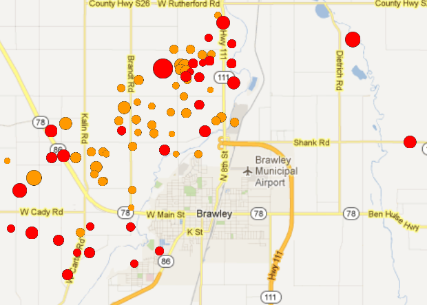
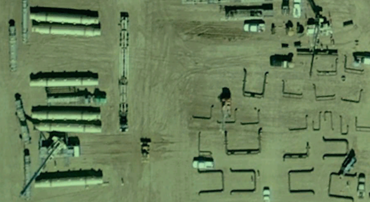
This is right in the middle of the swarm. Pipeline construction? Fracking? Possible cause or something that could be damaged by the quakes?
new topics
-
A Warning to America: 25 Ways the US is Being Destroyed
New World Order: 43 minutes ago -
America's Greatest Ally
General Chit Chat: 1 hours ago -
President BIDEN's FBI Raided Donald Trump's Florida Home for OBAMA-NORTH KOREA Documents.
Political Conspiracies: 6 hours ago -
Maestro Benedetto
Literature: 8 hours ago -
Is AI Better Than the Hollywood Elite?
Movies: 8 hours ago -
Las Vegas UFO Spotting Teen Traumatized by Demon Creature in Backyard
Aliens and UFOs: 11 hours ago
top topics
-
President BIDEN's FBI Raided Donald Trump's Florida Home for OBAMA-NORTH KOREA Documents.
Political Conspiracies: 6 hours ago, 27 flags -
Krystalnacht on today's most elite Universities?
Social Issues and Civil Unrest: 17 hours ago, 9 flags -
Supreme Court Oral Arguments 4.25.2024 - Are PRESIDENTS IMMUNE From Later Being Prosecuted.
Above Politics: 17 hours ago, 8 flags -
Weinstein's conviction overturned
Mainstream News: 16 hours ago, 8 flags -
Gaza Terrorists Attack US Humanitarian Pier During Construction
Middle East Issues: 12 hours ago, 8 flags -
Massachusetts Drag Queen Leads Young Kids in Free Palestine Chant
Social Issues and Civil Unrest: 14 hours ago, 7 flags -
Las Vegas UFO Spotting Teen Traumatized by Demon Creature in Backyard
Aliens and UFOs: 11 hours ago, 6 flags -
Meadows, Giuliani Among 11 Indicted in Arizona in Latest 2020 Election Subversion Case
Mainstream News: 14 hours ago, 5 flags -
2024 Pigeon Forge Rod Run - On the Strip (Video made for you)
Automotive Discussion: 12 hours ago, 4 flags -
Is AI Better Than the Hollywood Elite?
Movies: 8 hours ago, 3 flags
active topics
-
Salvador Dali's Moustaches
People • 28 • : zosimov -
Is AI Better Than the Hollywood Elite?
Movies • 17 • : ThePsycheaux -
The best Rice dish i've ever tasted... Kimchi Rice
Food and Cooking • 26 • : lamhaocc -
A Warning to America: 25 Ways the US is Being Destroyed
New World Order • 1 • : 727Sky -
Massachusetts Drag Queen Leads Young Kids in Free Palestine Chant
Social Issues and Civil Unrest • 15 • : tarantulabite1 -
America's Greatest Ally
General Chit Chat • 1 • : BingoMcGoof -
How ageing is" immune deficiency"
Medical Issues & Conspiracies • 35 • : annonentity -
HORRIBLE !! Russian Soldier Drinking Own Urine To Survive In Battle
World War Three • 49 • : Freeborn -
Gaza Terrorists Attack US Humanitarian Pier During Construction
Middle East Issues • 30 • : Asher47 -
Electrical tricks for saving money
Education and Media • 8 • : anned1