It looks like you're using an Ad Blocker.
Please white-list or disable AboveTopSecret.com in your ad-blocking tool.
Thank you.
Some features of ATS will be disabled while you continue to use an ad-blocker.

Geoengineering - caught in the act?
page: 2share:
reply to post by burntheships
Hello Burn,
What is SRM?
And why does Bill Gates have one?
Thanks,
Tom
Hello Burn,
What is SRM?
And why does Bill Gates have one?
Thanks,
Tom
reply to post by pianopraze
You have already said that aircraft make contrails, and I see 5 or 6 pictures with a few aircraft with contrails. Aircraft fly at different altitudes and so you will get contrails at some altitudes and not others and also going into different air masses. I would suggest you look at some aeronautical navigation charts at SKYVECTOR.COM and see what routes are in your areas for normal IFR traffic. This also doesn't represent VFR traffic that will be below 18,000 ft.
Most of these jets are flying 30,000ft or higher and at 30,000ft the temperature is about 50 below zero. We know that the closer the dew point is to the temperature you will get contrails so if the air up there has any moisture the warmer air from the engines will produce contrails.
One question....how do you know the aircraft with contrails do not show on the radar?
I guess I'm just missing the huge leap from contrails to something else....
reply to post by tomdham
Solar Radiation Management is a method used in the large picture of
Geoengineering the atmosphere.
Here is a governing body on this:
srmgi.org
It is carried out in a number of ways, in which several are adding particulate matter
to the atmosphere to apply a "sun shade" to "cool" the planet.
Here is a very recent thread on Bill Gates, and his investments into Solar Radiation
Management and Geoengineering.
www.abovetopsecret.com...
Bill Gates Backs Climate Scientists Lobbying For Large-Scale Geoengineering
www.guardian.co.uk
The Royal Society is involved heavily...the preferred method by The Royal Society is also
fleets of modifeid aircraft!
times247.com
coto2.wordpress.co m
coto2.files.wordpress.com
Solar Radiation Management is a method used in the large picture of
Geoengineering the atmosphere.
Here is a governing body on this:
srmgi.org
It is carried out in a number of ways, in which several are adding particulate matter
to the atmosphere to apply a "sun shade" to "cool" the planet.
Here is a very recent thread on Bill Gates, and his investments into Solar Radiation
Management and Geoengineering.
www.abovetopsecret.com...
Bill Gates Backs Climate Scientists Lobbying For Large-Scale Geoengineering
www.guardian.co.uk
A small group of leading climate scientists, financially supported by billionaires including Bill Gates, are lobbying governments and international bodies to back experiments into manipulating the climate on a global scale to avoid catastrophic climate change.
The scientists, who advocate geoengineering methods such as spraying millions of tonnes of reflective particles of sulphur dioxide 30 miles above earth, argue that a "plan B" for climate change.....
The Royal Society is involved heavily...the preferred method by The Royal Society is also
fleets of modifeid aircraft!
But the option that is taken most seriously is altogether grander in conception and scale. The scheme proposes nothing less than the transformation of the chemical composition of the Earth's atmosphere so that humans can regulate the temperature of the planet as desired. Like volcanic eruptions, it involves injecting sulphur dioxide gas into the stratosphere to blanket the Earth with tiny particles that reflect solar radiation.
Various schemes have been proposed, with the most promising being adaptation of high-flying aircraft fitted with extra tanks and nozzles to spray the chemicals. A fleet of 747s could do the job. www.guardian.co.uk...
times247.com
coto2.wordpress.co m
coto2.files.wordpress.com
edit on 10-3-2012 by
burntheships because: (no reason given)
Originally posted by ProudBird
reply to post by pianopraze
You are correct in your assumptions. March 7, times as noted on photos.
Don't know if you saw my edit.....as to the radiosonde date 7 March, @0000Z....that was data from nearly 24 hours before the evening of March 7, in the USA.
Ok, so March 7 9pm EST would be March 8 0100 UTC, you are correct that I got the wrong shot on one, but even when i move the time on the UTC photo so it shows 9pm.... the conditions do not exist for contrails!
There was no conditions for contrails.
reply to post by Xtrozero
GOOD idea.....
I will help.
@ the OP, pianopraze:
You used Blackburg, VA, radiosonde....I am guessing at a nearby airport to center the SkyVector map on. Hope Roanoke is is a good choice?
Here:
Enroute H-10
That (^ ^ ^) is a High Enroute Chart for your area. From that link you can interface with the website and look at more. I'm happy to help, with answers to questions about how to read any of the Charts.
To help orient yourself (location) on the High Chart, since it lacks any landmark information, you can use the CG-21 WAC Chart.
The other one, the Cincinnati chart is also used for VFR, and in print edition has a larger scale, more detail. Of course, either this or the WAC can be zoomed in or out, online.
GOOD idea.....
I would suggest you look at some aeronautical navigation charts at SKYVECTOR.COM and see what routes are in your areas for normal IFR traffic.
I will help.
@ the OP, pianopraze:
You used Blackburg, VA, radiosonde....I am guessing at a nearby airport to center the SkyVector map on. Hope Roanoke is is a good choice?
Here:
Enroute H-10
That (^ ^ ^) is a High Enroute Chart for your area. From that link you can interface with the website and look at more. I'm happy to help, with answers to questions about how to read any of the Charts.
To help orient yourself (location) on the High Chart, since it lacks any landmark information, you can use the CG-21 WAC Chart.
The other one, the Cincinnati chart is also used for VFR, and in print edition has a larger scale, more detail. Of course, either this or the WAC can be zoomed in or out, online.
edit on Sat 10 March 2012
by ProudBird because: (no reason given)
Looking at you last few pictures I can still see the few contrails from your first pictures of them. They are still skinny but breaking up. I do not
see the massive number of aircraft in your pictures needed to make the last picture, except for the 2 or 3 small contrails ones.
I suggest that last picture is just cloud formation since it would be impossible for a thin contrail to expand so massively in a few short minutes. Plus at the point of disperse state in the last pictures a chemtrail would be invisible, so it is only cloud formation, and one can easily still see the few contrails made by the aircraft as not part of that formation.
I suggest that last picture is just cloud formation since it would be impossible for a thin contrail to expand so massively in a few short minutes. Plus at the point of disperse state in the last pictures a chemtrail would be invisible, so it is only cloud formation, and one can easily still see the few contrails made by the aircraft as not part of that formation.
reply to post by pianopraze
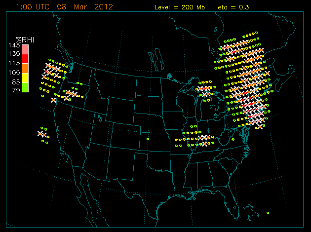
I am looking at that one chart there.
The pressure level it is depicting is 200 mb. Also, I have visited that website before....it is a forecast only, not a hard-and-fast definitive indicator of "yes/no" contrails.
Here is a small table of millibar to altitude, for reference:
www.boqueteweather.com...
So, 200 mb is about 39,000 feet. This is only a sliver of a "snap-shot" of part of the sky, and the atmosphere.
You need to assess and encompass the full range from about 300 mb to 200 mb....so, 30,000 to 39,000 feet. A LOT of variance can occur in that range of altitude. Both just in physical location, and over time.
edit on Sat 10 March 2012 by ProudBird because: (no reason given)
Originally posted by Xtrozero
reply to post by pianopraze
You have already said that aircraft make contrails, and I see 5 or 6 pictures with a few aircraft with contrails. Aircraft fly at different altitudes and so you will get contrails at some altitudes and not others and also going into different air masses. I would suggest you look at some aeronautical navigation charts at SKYVECTOR.COM and see what routes are in your areas for normal IFR traffic. This also doesn't represent VFR traffic that will be below 18,000 ft.
Most of these jets are flying 30,000ft or higher and at 30,000ft the temperature is about 50 below zero. We know that the closer the dew point is to the temperature you will get contrails so if the air up there has any moisture the warmer air from the engines will produce contrails.
One question....how do you know the aircraft with contrails do not show on the radar?
I guess I'm just missing the huge leap from contrails to something else....
There were two types of planes in the air... those making normal contrails, about what the app shows they should have given current conditions. Then there were these others, flying at approximately the same altitude making these huge spreading contrails.
I can tell which ones are on the radar because I know where I was in relation. You can see those flights in the sky not making contrails. The ones making the large spreading contrails were the ones NOT LISTED on flight aware.
The data for 30k shows NO conditions for these contrails either.
Originally posted by Xtrozero
I suggest that last picture is just cloud formation since it would be impossible for a thin contrail to expand so massively in a few short minutes.
And I suggest that is a ridiculous assumption. The photos clearly show contrails expanding.
This is not natural could formation!
Originally posted by ProudBird
reply to post by pianopraze
I am looking at that one chart there.
The pressure level it is depicting is 200 mb. Also, I have visited that website before....it is a forecast only, not a hard-and-fast definitive indicator of "yes/no" contrails.
It squares with the observed data on those dates.
Your squiggling every which way, but there was no conditions for these contrail formation.
Also there were planes that were making them, and planes that were not. The ones making them were not on flight aware. The ones not making them were on flight aware.
reply to post by pianopraze
Not true:
Absolutely not true. I showed you on the Appleman Chart.
Even using the previous nights' radiosonde data....@300 mb it was -51° C, and 16% RH.
Go into the Appleman Chart......along the bottom, find -51° C. Now, go up to the 300 mb level, on the left. Where those two side intersect, is in the range that is labelled "Always contrails".
Period.
Not true:
Your squiggling every which way, but there was no conditions for these contrail formation.
Absolutely not true. I showed you on the Appleman Chart.
Even using the previous nights' radiosonde data....@300 mb it was -51° C, and 16% RH.
Go into the Appleman Chart......along the bottom, find -51° C. Now, go up to the 300 mb level, on the left. Where those two side intersect, is in the range that is labelled "Always contrails".
Period.
Originally posted by burntheships
Originally posted by Xtrozero
I suggest that last picture is just cloud formation since it would be impossible for a thin contrail to expand so massively in a few short minutes.
And I suggest that is a ridiculous assumption. The photos clearly show contrails expanding.
This is not natural could formation!
Can you not see the thin contrails still in the pictures? Where are the pictures of the aircraft making those huge super expanding contrails? The OP shows a picture with 2 aircraft and those contrails are still thin and breaking up in the last picture.
Clouds can form very quickly and get that pattern easily. You cannot convince me if there is no picture actually showing aircraft making the huge contrails with the smaller ones still there. That is a huge chunk of the sky and you think aircraft can fill it up in 10 mins, with no actual picture of these super aircraft? I kind of find that a ridiculous assumption.
edit on 10-3-2012 by Xtrozero because: (no reason given)
reply to post by pianopraze
And, again.....this is a confirmation bias problem, I allege.
You, yourself admitted that you went in from your aborted photo-op and then checked Flight Aware. This is a crucial time issue. And, memory and impression issue.
I am trying to point out that although an excellent tool, it is important to understand how to properly use and interpret the information that Flight Aware offers, bearing in mind(to repeat) the known time lag.
One more thing, and since I can't be there to show in person, and perhaps tutor....many people seem to think that "only" the flights seen on Flight Aware that are "directly" over their heads are ones to consider.
When you look up and see the contrails (and judging from the photos, I say this also) you can see airplanes that are many miles down-range. The distance may be up to 50 miles, or more even. This has to be considered, when viewing the Flight Aware data, to take into account the full range of viewing ability.
Distances can be wrongly estimated, constantly, without the accompanying experience to help in interpreting what one sees.
The ones making them were not on flight aware. The ones not making them were on flight aware.
And, again.....this is a confirmation bias problem, I allege.
You, yourself admitted that you went in from your aborted photo-op and then checked Flight Aware. This is a crucial time issue. And, memory and impression issue.
I am trying to point out that although an excellent tool, it is important to understand how to properly use and interpret the information that Flight Aware offers, bearing in mind(to repeat) the known time lag.
One more thing, and since I can't be there to show in person, and perhaps tutor....many people seem to think that "only" the flights seen on Flight Aware that are "directly" over their heads are ones to consider.
When you look up and see the contrails (and judging from the photos, I say this also) you can see airplanes that are many miles down-range. The distance may be up to 50 miles, or more even. This has to be considered, when viewing the Flight Aware data, to take into account the full range of viewing ability.
Distances can be wrongly estimated, constantly, without the accompanying experience to help in interpreting what one sees.
edit on Sat 10 March 2012 by ProudBird because: (no reason given)
Originally posted by pianopraze
Originally posted by Xtrozero
reply to post by pianopraze
There were two types of planes in the air... those making normal contrails, about what the app shows they should have given current conditions. Then there were these others, flying at approximately the same altitude making these huge spreading contrails.
I can tell which ones are on the radar because I know where I was in relation. You can see those flights in the sky not making contrails. The ones making the large spreading contrails were the ones NOT LISTED on flight aware.
The data for 30k shows NO conditions for these contrails either.
Why didn't you take one picture of these "other" aircraft since you did so well with the normal contrail ones? We see only the after effect and not the cause. Don't you think that would be the MOST important pictures to take?
It also would be an incredible sight to see so many aircraft dumping out the amount needed to fill the sky in 10 mins as you suggest....
Cloud formation...
reply to post by burntheships
Thanks for the injection of common sense...through all the double speak this IS the point.
I add the comment, that if the planes were criss crossing the sky., the patterns are highly suspicious to say the least...how often do you see checkerboard contrails in any quantity?
(I would have liked to see more pattern details of this happening though....if only to shut up the shills....if you have more pics of the progression Piano, can you post them?
In other words, here is some unusual flight patterns, and unusually huge formations of contrails sticking around for a long time after....
While this is going on, other aircraft, at approximately equal heights are not producing these persistent contrails/clouds...which eventually cover the whole sky from horizon to horizon by the look of it....
This is indeed not your usual activity is it?
I would like a count of the pattern producing aircraft and a rough idea how many passes they used to cross the sky in checkers..... piano?
do you have these figures??
reply to post by pianopraze
In order to dispel the "relax!" mongering and prove these aren't normal contrails or cloud formation, you're going to have to take more photos around the same time.
Now that daylight savings time is going to change tomorrow, it will be interesting to see if the same thing happens at the same time or later. If this is normal airplane activity, the time should remain the same. If they are intentionally spraying at night as a means of concealing nefarious activity, the planes should be doing this later than the times you noticed and started photographing. Do you agree with this?
Originally posted by Xtrozero
Originally posted by burntheships
Originally posted by Xtrozero
I suggest that last picture is just cloud formation since it would be impossible for a thin contrail to expand so massively in a few short minutes.
And I suggest that is a ridiculous assumption. The photos clearly show contrails expanding.
This is not natural could formation!
Can you not still see the thin contrails still in the pictures? Where are the pictures of the aircraft making those huge super expanding contrails? The OP shows a picture with 2 aircraft and those contrails are still thin and breaking up in the last picture.
Clouds can form very quickly and get that pattern easily. You cannot convince me if there is no picture actually showing aircraft making the huge contrails with the smaller ones still there. That is a huge chunk of the sky and you think aircraft can fill it up in 10 mins, with no actual picture of these super aircraft? I kind of find that a ridiculous assumption.
Those skinny contrails are in the larger spreading contrails that had been sprayed only minutes before, and spread out making those larger contrails which encase those "skinny contrails"
This was not cloud formation, the contrails spread and made the clouds. Every cloud in the sky was a contrail.. I watched them spread and photographed them as they did so. This all took only 20 minutes to encase the whole sky in a criss cross grid of contrails which formed huge spreading clouds.
The most impressive of them were actually to the north and west, but as i was photographing at night it's hard to capture, so i focused on the ones to the east which show up because of the moonlight. It was the contrails that formed these clouds, i watched it very quickly happen over 20 minutes from crystal clear to completely encased in clouds formed from the contrails.
Originally posted by niceguybob
Well done.
Are you sure your not up here at Lake Tahoe? Because that's how it happens here.
GORGEOUS Blue Skies. You can watch planes flying in all directions leaving a "scoach" of vapor errr contrail.
And then these other goshdarn planes leave trails that last forever and seem to dissipitate across the skyline leaving a goshdarn coating.
Those other goshdarn planes are just leaving contrails too at a certain elevation, but being as dumb as I am, I seem to notice they last a LOT longer in the sky,but I just don't understand science.
You'll NEVER win on ATS with people that want the proof of WHAT they are before you can claim you even see them. This discussion has gone on for over 8 years. As more info comes in it doesn't matter.
Until you have a confirmed source of who is spraying what and why?
They don't exist.
AND If you provided a good source? Bad source, so they don't exist.
Good pics though, you just don't understand the science behind what your looking at. (sneer)
Hello Bob, I am sure you are a nice guy, but I would like to ask a question or two of you and all of the other "chemtrail" proponents.
I live in Abu Dhabi, we have minimal contrail activity. Even in the desert and Dubai and the Persian Gulf.
There are no Cirrus clouds to speak of. Sometimes we get rain. But no "chemtrails".
Why would that be?
Upper atmospheric conditions?
They are not spraying in the Middle East?
Maybe TPTB don't want to contaminate the oil?
Hmmm? Food for thought?
I have asked in numerous "chemtrail" threads:
WHAT is the exact composition of said "chemtrails" put forth with tested and verifiable evidence?
There is none. Period.
I have been castigated by ProudBird and Unicuss for making light of the this because I showed the causation, although sarcastic, of a contrail photo in Bahrain linked to their social unrest. (all my posts were blocked)
I have been told that this is not a subject for sarcasm or showing the "chemmies" as out-right fools.
This subject should be taken in a scientific and critical forum to show the "newbies" how ridiculous "chemtrails" are.
They do not appreciate the time and more than justifiable lecturing on flight aware, contrail science (of which I am constant visitor) from the above mentioned experts.
Please, I will ask one more time please inform yourself and give the answer to put this topic to bed once and for all:
Produce the evidence of the contents of the "chemtrails", verifiable, peer reviewed, documented.
Not just: "I saw these streaks, contrails, cirrus clouds,"chemtrails" in the sky", ad nauseum!
Sorry PB, I just can't stop with the ridicule of this hoax.
(Oh yeah, don't forget sound travels through space!! )
73's,
Tom
edit on 10-3-2012 by tomdham because: spelling
Originally posted by ProudBird
reply to post by pianopraze
Not true:
Your squiggling every which way, but there was no conditions for these contrail formation.
Absolutely not true. I showed you on the Appleman Chart.
Even using the previous nights' radiosonde data....@300 mb it was -51° C, and 16% RH.
Go into the Appleman Chart......along the bottom, find -51° C. Now, go up to the 300 mb level, on the left. Where those two side intersect, is in the range that is labelled "Always contrails".
Period.
NOAA says there was no conditions for contrails, squirm as you will.
Why are you using something you know has been show as faulty?
But for argument, not that I believe it, but for arguments sake even if you were right... Why would one set of planes not on the radar be the ones forming them when the ones on the radar were not forming them?
new topics
-
A Warning to America: 25 Ways the US is Being Destroyed
New World Order: 2 hours ago -
President BIDEN's FBI Raided Donald Trump's Florida Home for OBAMA-NORTH KOREA Documents.
Political Conspiracies: 8 hours ago -
Maestro Benedetto
Literature: 9 hours ago -
Is AI Better Than the Hollywood Elite?
Movies: 9 hours ago
top topics
-
President BIDEN's FBI Raided Donald Trump's Florida Home for OBAMA-NORTH KOREA Documents.
Political Conspiracies: 8 hours ago, 27 flags -
Weinstein's conviction overturned
Mainstream News: 17 hours ago, 8 flags -
Gaza Terrorists Attack US Humanitarian Pier During Construction
Middle East Issues: 14 hours ago, 8 flags -
Massachusetts Drag Queen Leads Young Kids in Free Palestine Chant
Social Issues and Civil Unrest: 16 hours ago, 7 flags -
Las Vegas UFO Spotting Teen Traumatized by Demon Creature in Backyard
Aliens and UFOs: 13 hours ago, 6 flags -
A Warning to America: 25 Ways the US is Being Destroyed
New World Order: 2 hours ago, 6 flags -
Meadows, Giuliani Among 11 Indicted in Arizona in Latest 2020 Election Subversion Case
Mainstream News: 16 hours ago, 5 flags -
2024 Pigeon Forge Rod Run - On the Strip (Video made for you)
Automotive Discussion: 14 hours ago, 4 flags -
Is AI Better Than the Hollywood Elite?
Movies: 9 hours ago, 3 flags -
The functionality of boldening and italics is clunky and no post char limit warning?
ATS Freshman's Forum: 15 hours ago, 1 flags
active topics
-
President BIDEN's FBI Raided Donald Trump's Florida Home for OBAMA-NORTH KOREA Documents.
Political Conspiracies • 18 • : nugget1 -
Gaza Terrorists Attack US Humanitarian Pier During Construction
Middle East Issues • 33 • : FlyersFan -
Weinstein's conviction overturned
Mainstream News • 24 • : burritocat -
-@TH3WH17ERABB17- -Q- ---TIME TO SHOW THE WORLD--- -Part- --44--
Dissecting Disinformation • 690 • : burritocat -
University of Texas Instantly Shuts Down Anti Israel Protests
Education and Media • 266 • : SchrodingersRat -
New whistleblower Jason Sands speaks on Twitter Spaces last night.
Aliens and UFOs • 66 • : baablacksheep1 -
HORRIBLE !! Russian Soldier Drinking Own Urine To Survive In Battle
World War Three • 50 • : F2d5thCavv2 -
Russia Ukraine Update Thread - part 3
World War Three • 5732 • : F2d5thCavv2 -
The Acronym Game .. Pt.3
General Chit Chat • 7751 • : F2d5thCavv2 -
Salvador Dali's Moustaches
People • 28 • : zosimov