It looks like you're using an Ad Blocker.
Please white-list or disable AboveTopSecret.com in your ad-blocking tool.
Thank you.
Some features of ATS will be disabled while you continue to use an ad-blocker.

Quake Watch 2012
page: 30share:
Source: USGS
Locat ion in Google Maps
As per muzzy's prediction???
Quakes for the area mag 6+ 200km circular search
Search data
Additional data not in that list (in reverse order from today)
Update and reviewed by a seismologist. Does not mean it will not change, just that it is confirmed as an earthquake and not a dolphin fart. No phase data as yet. Waiting for the tensor solutions.
The average of the mb data is 6.53+ and the phase data shows mb 6.5 so this one probably won't be chaning unless the centroid tensor comes out differently.
No tsunami:
ptwc.weather.gov...
Magnitude 6.9 (Preliminary magnitude — update expected within 15 minutes)
Date-Time
Thursday, February 02, 2012 at 13:34:39 UTC
Friday, February 03, 2012 at 12:34:39 AM at epicenter
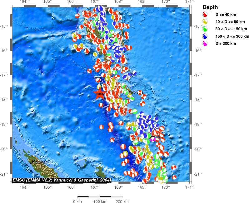
Location 17.877°S, 167.225°E
Depth 10 km (6.2 miles) set by location program
Region VANUATU
Distances
115 km (71 miles) W (263°) from PORT-VILA, Vanuatu
261 km (162 miles) S (178°) from Santo (Luganville), Vanuatu
283 km (176 miles) NW (310°) from Isangel, Vanuatu
1807 km (1123 miles) ENE (57°) from Brisbane, Australia
Location Uncertainty Error estimate not available
Parameters NST= 10, Nph=0, Dmin=0 km, Rmss=0 sec, Gp=108°,
M-type="moment" magnitude from initial P wave (tsuboi method) (Mi/Mwp), Version=B
Source
NOAA Pacific Tsunami Warning Center
Event ID pt12033002
Locat ion in Google Maps
As per muzzy's prediction???
Quakes for the area mag 6+ 200km circular search
CAT YEAR MO DA ORIG TIME LAT LONG DEP MAGNITUDE IEM DTSVNWG DIST
NFO km
TF
PDE 1973 06 05 031225.80 -17.19 167.81 24 6.5 UKPAS 3F. ....... 98
PDE 1974 05 26 013211.20 -17.70 167.75 13 6.1 UKPAS 5F. ....... 59
PDE 1974 05 26 152424 -17.62 167.49 7 6.2 mbGS ... ....... 40
PDE 1978 09 01 041642.10 -17.41 168.00 32 6.2 UKBRK ... ....... 96
PDE 1979 01 27 1815 -18.54 168.21 25 6.3 MsGS 5F. ....... 127
PDE 1979 08 17 125907.40 -17.72 167.85 17 6.2 UKBRK 4F. ....... 68
PDE 1979 08 26 114724.50 -17.67 167.68 10 6.2 UKPAS 3F. ....... 53
PDE 1981 07 15 075908.47 -17.26 167.60 30 7.1 MSBRK .DM ....... 78
PDE 1982 01 18 042337.75 -17.29 167.81 44 6.0 MSBRK ..M ....... 90
PDE 1985 07 03 155548.77 -17.24 167.83 28 6.7 MSBRK ..M ....... 95
PDE 1986 10 25 204701.80 -17.66 168.13 30 6.2 MSBRK ..M ....... 99
PDE 1987 09 28 114708.61 -18.41 168.06 30 6.8 MsGS .F. ....... 105
PDE 1987 09 28 134613.95 -18.55 168.16 25 6.5 MsGS ..M ....... 123
PDE 1987 09 30 013928.09 -18.16 167.87 51 6.3 MsGS ..M ....... 74
PDE 1987 11 26 172854.73 -16.35 168.12 18 6.3 MsGS ..M ....... 193
PDE 1987 11 27 133318.05 -16.37 168.12 28 6.4 MsGS ..M ....... 191
PDE 1988 08 20 081937.64 -16.48 167.17 21 6.1 MSPAS ..M ....... 154
PDE 1990 03 05 163812.57 -18.32 168.06 20 7.1 MwGS 5FM ....... 101
PDE 1990 09 23 175402.96 -17.73 167.61 10 6.2 MsGS ..M ....... 43
PDE 1992 04 07 224729.45 -16.87 168.13 16 6.0 MwHRV ..M ....... 147
PDE 1992 04 08 133656.43 -16.78 168.31 14 6.0 MwHRV ..M ....... 166
PDE 1994 02 16 064858.04 -18.99 168.13 13 6.4 MwGS ..M ....... 156
PDE 1994 04 06 121344.97 -17.37 167.82 17 6.2 MwHRV ..M ....... 83
PDE 1994 05 04 063736.08 -17.05 168.26 206 6.2 MwGS ..M ....... 143
PDE 1994 07 13 023556.02 -16.62 167.52 33 7.2 MwHRV 6FM ....... 142
PDE 1994 07 13 031319.31 -16.81 167.25 33 6.7 MwHRV ..M ....... 117
PDE 1994 07 24 175540.38 -16.97 167.57 20 6.4 MwHRV ..M ....... 107
PDE 1994 10 01 163520.79 -17.75 167.68 16 6.5 MwHRV ..M ....... 50
PDE 1994 10 01 174637.58 -17.77 167.83 33 6.2 MwHRV ..M ....... 65
PDE 1998 07 18 164119.44 -18.37 168.17 33 6.1 MwGS .FM ....... 113
PDE 1999 11 26 132115.57 -16.42 168.21 33 7.5 MwHRV .CM .T....S 191
PDE 2000 02 29 224458.03 -18.16 169.01 33 6.0 MwHRV ..M ....... 191
PDE 2001 09 29 024007.38 -18.50 168.16 33 6.4 MwHRV ..M ....... 120
PDE 2001 09 30 190118.71 -18.42 168.12 33 6.2 MwGS .FM ....... 112
PDE 2001 10 26 230550.95 -18.49 168.11 33 6.1 MwHRV ..M ....... 115
PDE 2001 12 12 125318.41 -17.19 167.72 33 6.1 MwGS ..M ....... 92
PDE 2002 01 02 172248.76 -17.60 167.86 21 7.2 MwHRV .CM .T....S 73
PDE 2002 01 03 101736.30 -17.66 168.00 10 6.6 MwHRV .FM ....... 85
PDE 2002 01 15 044759.85 -17.33 167.72 10 6.0 MwHRV ..M ....... 79
PDE 2003 05 13 212114.05 -17.29 167.74 33 6.3 MwGS .FM ....... 85
PDE 2004 04 22 101112.66 -17.59 167.89 10 6.0 MwHRV .FM ....... 77
PDE 2004 04 27 232818.88 -17.76 167.76 10 6.0 MwHRV .FM ....... 57
PDE 2005 09 25 125546.60 -17.51 167.80 30 6.1 MwGS 4FM ....... 72
PDE 2006 01 23 060258.14 -17.39 167.71 23 6.4 MwHRV 3FM ....... 74
PDE 2008 03 12 112334.06 -16.57 167.34 13 6.4 MwUCMT ..M ....... 145
PDE 2008 03 12 113655.28 -16.49 167.18 10 6.3 MwGCMT ..M ....... 153
PDE 2008 11 04 183545.27 -17.14 168.46 205 6.3 MwUCMT ..M ....... 154
PDE 2009 06 02 021703.51 -17.76 167.95 15 6.3 MwUCMT 3CM ......S 77
PDE 2009 06 12 094415.06 -17.61 167.81 15 6.0 MwUCMT 3FM ....... 68
PDE-W 2010 08 10 052344.98 -17.54 168.07 25 7.3 MwUCMT 7FM .T..... 96
PDE-W 2011 01 09 100344.28 -19.16 168.31 24 6.5 MwWCMT 3FM ....... 181
PDE-W 2011 01 09 172151.65 -19.20 168.15 18 6.1 MwWCMT ..M ....... 176
PDE-W 2011 03 17 024800.03 -17.27 167.83 17 6.2 MwWCMT 4FM ....... 92
PDE-W 2011 08 20 165502.81 -18.36 168.14 32 7.2 MwWCMT 5FM ....... 110
PDE-W 2011 08 20 171306.38 -18.31 168.16 35 6.5 MwGCMT ..M ....... 109
PDE-W 2011 08 20 181923.55 -18.31 168.22 28 7.1 MwWCMT 5FM ....... 115
PDE-W 2011 08 24 230617.09 -18.16 167.73 13 6.2 MwWCMT 5FM ....... 61
Search data
Additional data not in that list (in reverse order from today)
Date/Time UTC,Latitude,Longitude,Magnitude,Depth(Km),Location
2012-02-02 13:34:38, -17.810, 167.149, 6.9, 10.1, Vanuatu
2011-09-11 23:37:36, -18.186, 167.873, 6.0, 35.1, Vanuatu
2011-09-04 21:44:21, -19.155, 168.696, 6.1, 59.4, Vanuatu
2011-09-03 22:55:36, -20.584, 169.696, 7.0, 132.4, Vanuatu
2011-08-24 23:06:16, -18.179, 167.729, 6.2, 10.1, Vanuatu
Update and reviewed by a seismologist. Does not mean it will not change, just that it is confirmed as an earthquake and not a dolphin fart. No phase data as yet. Waiting for the tensor solutions.
The average of the mb data is 6.53+ and the phase data shows mb 6.5 so this one probably won't be chaning unless the centroid tensor comes out differently.
No tsunami:
000
WEHW42 PHEB 021342
TIBHWX
HIZ001>003-005>009-012>014-016>021-023>026-021542-
TSUNAMI INFORMATION STATEMENT NUMBER 1
NWS PACIFIC TSUNAMI WARNING CENTER EWA BEACH HI
342 AM HST THU FEB 02 2012
TO - CIVIL DEFENSE IN THE STATE OF HAWAII
SUBJECT - TSUNAMI INFORMATION STATEMENT
THIS STATEMENT IS FOR INFORMATION ONLY. NO ACTION REQUIRED.
AN EARTHQUAKE HAS OCCURRED WITH THESE PRELIMINARY PARAMETERS
ORIGIN TIME - 0335 AM HST 02 FEB 2012
COORDINATES - 17.9 SOUTH 167.2 EAST
LOCATION - VANUATU ISLANDS
MAGNITUDE - 6.9 MOMENT
EVALUATION
BASED ON ALL AVAILABLE DATA A DESTRUCTIVE PACIFIC-WIDE TSUNAMI IS
NOT EXPECTED AND THERE IS NO TSUNAMI THREAT TO HAWAII. REPEAT. A
DESTRUCTIVE PACIFIC-WIDE TSUNAMI IS NOT EXPECTED AND THERE IS NO
TSUNAMI THREAT TO HAWAII.
THIS WILL BE THE ONLY STATEMENT ISSUED FOR THIS EVENT UNLESS
ADDITIONAL DATA ARE RECEIVED.
$$
ptwc.weather.gov...
edit on 2/2/2012 by PuterMan because: (no reason given)
reply to post by PuterMan
"To: [email protected]
From: [email protected]
Subject: [SCARDEC] Recent Mw=7.2 earthquake, located in VANUATU
Message-Id:
Date: Thu, 2 Feb 2012 15:13:11 +0100 (CET)
2012 02 02 13 34 39.0 -17.810 167.149 12.0 7.2 173 56 -129 48 50 -47
INDICATIF_SEISME 20120202_133439_VANUATU
##########################################################
Errors-To: [email protected]
USGS research CMT: maintained and developed by Jascha Polet at Cal Poly Pomona.
This is a research system and solutions are *not* official USGS earthquake magnitudes.
AUTOMATIC solution, not reviewed by a seismologist, new beta version 12/7/10
More details on this rCMT at neic.cr.usgs.gov...
usr/passwd : rcmt/rcmt
- - - - - - - - - - - - - - - - - - - - - - - - - - - - - - - - - - - - - - - - - - - - - - - - - -
General region : 2012wmay VANUATU
surface waves (3.0,3.5,7,7.5 mHz)
Stations used : CASY KIP MAJO PET PMG RPN SNZO TAU YSS
Origin time: 2012 33 13 34 38
Origin time reformatted: 2012-02-02 13:34:38
Original location (lat,lon,depth) : -17.8000 167.100 14
Moment tensor (x1.e26 dyncm) :
Mrr : -2.832489 Mtt : -0.999027
Mff : 3.831516 Mrt : -3.989357
Mrf : 15.232629 Mtf : 1.987044
T-axis: moment= 16.147 plunge= 39.213 azimuth= 265.740
N-axis: moment= 0.184 plunge= 10.198 azimuth= 167.299
P-axis: moment= -16.332 plunge= 48.964 azimuth= 65.371
best double couple: Mo= 16.240(x1.e26 dyncm) Mw=7.4 tau= 14.0
nodal planes (strike/dip/slip): 50.86/ 11.36/-25.99 166.41/ 85.05/-100.24
Centroid location : -17.234 167.089 13.291
Centroid time : 8.210
Variance reduction (%) : 66.4
***********
****-o ****
***-----o ***
**--------o **
**---------oo **
*------------o o*
*-------------o o*
**-------------oo **
*---------------o P o*
**---------------oo o**
**------T---------o+ o**
**----------------oo o**
*-----------------o oo*
**----------------o o**
*-----------------o oo *
*----------------o oo *
**---------------o ooo**
**o-------------oo ooo **
***oo----------o oooo***
****ooooooooooo****
***********
0- 30- 60- 90- 120- 150- 180- 210- 240- 270- 300- 330-
z-comp: 1 0 1 0 1 0 2 0 1 0 0 2
r-comp: 1 0 1 0 0 0 3 0 1 0 0 0
t-comp: 1 0 1 0 1 0 3 0 0 0 0 0
Total number of traces used = 20
number of runs = 11
starttime = Thu Feb 2 06:48:50 MST 2012
depth loop = Thu Feb 2 07:24:39 MST 2012 - Thu Feb 2 07:25:15 MST 2012
Solution produced by inversion of channels with var red > 2%
Initial magnitude 6.9 : depth search was triggered. Initial depth 10 km.
DInit CMTDep VarRed
-------------------
020 10.000 56.94
040 14.194 60.34
060 17.922 59.23
100 10.000 57.27
200 324.795 13.00
300 419.546 13.81
400 470.974 13.87
500 510.473 13.03
600 532.590 12.52
_______________________________________________
researchCMT mailing list
You cannot post to this mailing list. It is for distribution only.
Questions comments? Ask Jascha, [email protected]
Archive: geohazards.cr.usgs.gov...
To unsubscribe: geohazards.usgs.gov...
##########################################################
To: [email protected]
X-Original-Message-ID:
MIME-Version: 1.0
Content-Type: text/plain; charset=us-ascii
Message-ID:
Subject: MT solution GFZ event gfz2012chmz
GFZ Event gfz2012chmz
12/02/02 13:34:39.99
Vanuatu Islands
Epicenter: -17.74 167.21
MW 7.0
GFZ MOMENT TENSOR SOLUTION
Depth 19 No. of sta: 16
Moment Tensor; Scale 10**19 Nm
Mrr=-2.56 Mtt=-0.67
Mpp= 3.22 Mrt=-1.03
Mrp= 0.63 Mtp=-0.67
Principal axes:
T Val= 3.90 Plg= 2 Azm=291
N -0.62 31 199
P -3.29 59 24
"
source(www.emsc-csem.org...
ex text
Now, can you explain it
"To: [email protected]
From: [email protected]
Subject: [SCARDEC] Recent Mw=7.2 earthquake, located in VANUATU
Message-Id:
Date: Thu, 2 Feb 2012 15:13:11 +0100 (CET)
2012 02 02 13 34 39.0 -17.810 167.149 12.0 7.2 173 56 -129 48 50 -47
INDICATIF_SEISME 20120202_133439_VANUATU
##########################################################
Errors-To: [email protected]
USGS research CMT: maintained and developed by Jascha Polet at Cal Poly Pomona.
This is a research system and solutions are *not* official USGS earthquake magnitudes.
AUTOMATIC solution, not reviewed by a seismologist, new beta version 12/7/10
More details on this rCMT at neic.cr.usgs.gov...
usr/passwd : rcmt/rcmt
- - - - - - - - - - - - - - - - - - - - - - - - - - - - - - - - - - - - - - - - - - - - - - - - - -
General region : 2012wmay VANUATU
surface waves (3.0,3.5,7,7.5 mHz)
Stations used : CASY KIP MAJO PET PMG RPN SNZO TAU YSS
Origin time: 2012 33 13 34 38
Origin time reformatted: 2012-02-02 13:34:38
Original location (lat,lon,depth) : -17.8000 167.100 14
Moment tensor (x1.e26 dyncm) :
Mrr : -2.832489 Mtt : -0.999027
Mff : 3.831516 Mrt : -3.989357
Mrf : 15.232629 Mtf : 1.987044
T-axis: moment= 16.147 plunge= 39.213 azimuth= 265.740
N-axis: moment= 0.184 plunge= 10.198 azimuth= 167.299
P-axis: moment= -16.332 plunge= 48.964 azimuth= 65.371
best double couple: Mo= 16.240(x1.e26 dyncm) Mw=7.4 tau= 14.0
nodal planes (strike/dip/slip): 50.86/ 11.36/-25.99 166.41/ 85.05/-100.24
Centroid location : -17.234 167.089 13.291
Centroid time : 8.210
Variance reduction (%) : 66.4
***********
****-o ****
***-----o ***
**--------o **
**---------oo **
*------------o o*
*-------------o o*
**-------------oo **
*---------------o P o*
**---------------oo o**
**------T---------o+ o**
**----------------oo o**
*-----------------o oo*
**----------------o o**
*-----------------o oo *
*----------------o oo *
**---------------o ooo**
**o-------------oo ooo **
***oo----------o oooo***
****ooooooooooo****
***********
0- 30- 60- 90- 120- 150- 180- 210- 240- 270- 300- 330-
z-comp: 1 0 1 0 1 0 2 0 1 0 0 2
r-comp: 1 0 1 0 0 0 3 0 1 0 0 0
t-comp: 1 0 1 0 1 0 3 0 0 0 0 0
Total number of traces used = 20
number of runs = 11
starttime = Thu Feb 2 06:48:50 MST 2012
depth loop = Thu Feb 2 07:24:39 MST 2012 - Thu Feb 2 07:25:15 MST 2012
Solution produced by inversion of channels with var red > 2%
Initial magnitude 6.9 : depth search was triggered. Initial depth 10 km.
DInit CMTDep VarRed
-------------------
020 10.000 56.94
040 14.194 60.34
060 17.922 59.23
100 10.000 57.27
200 324.795 13.00
300 419.546 13.81
400 470.974 13.87
500 510.473 13.03
600 532.590 12.52
_______________________________________________
researchCMT mailing list
You cannot post to this mailing list. It is for distribution only.
Questions comments? Ask Jascha, [email protected]
Archive: geohazards.cr.usgs.gov...
To unsubscribe: geohazards.usgs.gov...
##########################################################
To: [email protected]
X-Original-Message-ID:
MIME-Version: 1.0
Content-Type: text/plain; charset=us-ascii
Message-ID:
Subject: MT solution GFZ event gfz2012chmz
GFZ Event gfz2012chmz
12/02/02 13:34:39.99
Vanuatu Islands
Epicenter: -17.74 167.21
MW 7.0
GFZ MOMENT TENSOR SOLUTION
Depth 19 No. of sta: 16
Moment Tensor; Scale 10**19 Nm
Mrr=-2.56 Mtt=-0.67
Mpp= 3.22 Mrt=-1.03
Mrp= 0.63 Mtp=-0.67
Principal axes:
T Val= 3.90 Plg= 2 Azm=291
N -0.62 31 199
P -3.29 59 24
"
source(www.emsc-csem.org...
ex text
"Best Double Couple:Mo=3.6*10**19
NP1:Strike=174 Dip=55 Slip=-129
NP2: 49 51 -47
###--------
#####------------
#######----------------
#######------------------
#########------------------##
########-------- --------##
#########-------- P -------####
##########-------- -------#####
##########-----------------######
##########----------------#######
##########---------------########
##########--------------#########
##########-----------##########
#########---------###########
##########-----##############
########-################
---------##############
--------#########
------#####
#############################################################
This message is sent to you because you are subscribed to
the mailing list .
To unsubscribe, E-mail to:
To switch to the DIGEST mode, E-mail to
To switch to the INDEX mode, E-mail to
Send administrative queries to
##########################################################
"
source(www.emsc-csem.org...
reply to post by diamondsmith
So perhaps you can explain to me how you have a copy of the CMT solution sent to a french email address before the Global CMT solution is available?
Can you also explain why you posted this is response to the EMSC tensor solution map which is way over the top by the way?
OK I see where you got it now.
But you still have not explained it.............
edit on 2/2/2012 by PuterMan because: (no reason given)
I think I already did ,and very well.....for those who can read it...
reply to post by diamondsmith
OK then let me put it this way. For the benefit of those who do not know what a double couple is please describe in your own words (not copy and paste from the internet) what this is describing and how this might also be affected by non-DC solutions. Does every DC solution also have non-DC elements?
Just copying and pasting the text of the solution (without ex tags by the way - naughty naughty) does not explain what all the little coloured balls are and how they are interpreted.
This just leaves me cold and I frankly don't understand much of the mathematics behind it so I would appreciate your answer since it seems that you do otherwise why would you post it as an answer?
By the way, whist you were posting the tensor solution you did not notice that it said 7.2 Mw?
(Emphasis by me)
I guess perhaps you don't understand it as well as I hoped you might.
OK then let me put it this way. For the benefit of those who do not know what a double couple is please describe in your own words (not copy and paste from the internet) what this is describing and how this might also be affected by non-DC solutions. Does every DC solution also have non-DC elements?
Just copying and pasting the text of the solution (without ex tags by the way - naughty naughty) does not explain what all the little coloured balls are and how they are interpreted.
This just leaves me cold and I frankly don't understand much of the mathematics behind it so I would appreciate your answer since it seems that you do otherwise why would you post it as an answer?
By the way, whist you were posting the tensor solution you did not notice that it said 7.2 Mw?
2012 02 02 13 34 39.0 -17.810 167.149 12.0 7.2 173 56 -129 48 50 -47
INDICATIF_SEISME 20120202_133439_VANUATU
(Emphasis by me)
I guess perhaps you don't understand it as well as I hoped you might.
edit on 2/2/2012 by PuterMan because: (no reason given)
EMSC have gone to 7.1 Mw
Source: EMSC
Magnitude Mw 7.1
Region VANUATU
Date time 2012-02-02 13:34:39.0 UTC
Location 17.71 S ; 167.19 E
Depth 10 km
Distances 1190 km W Suva (pop 199,455 ; local time 01:34:39.0 2012-02-03)
119 km W Vila (pop 35,901 ; local time 00:34:39.0 2012-02-03)
Source: EMSC
reply to post by PuterMan
What an incredible amount of work, Puterman! Kudos
I especially enjoy the 2011 versus decade average anomaly graph, by region. Looking at that graph, region 3 needs to do some catching up--I just hope it will do so with a swarm of 5.9's and not one big one.
On another note, it looks like the Vanuatu earthquake surface waves are finally subsiding. That gave the globe a decent bell-ringing.
Just had a Moderate quake here Lower North Island 60 seconds ago , felt wobbly, no sudden jolt, went on for quite a while, so I'm picking 5+ at a fair
distance.
Will post when more info comes up.
Maybe there is something to this Moon thingy, Ken Ring predicted Feb 2 for 5+ in his newsletter.
Its the 3rd here NZDT, but still Feb 2 UTC
Here we go , 5.7 ML out to the NW in the Tasman Sea, in the area where we had the 6's in 2005 and 2006
location map
www.geonet.org.nz...
took a while for the S wave to get here, I looked at my laptop clock when it was happening, it said 7:01 (18:01 UTC
Geonet gave me a 4MM for my report from Raumati Beach
www.geonet.org.nz...
there probably won't be many aftershocks from this, being 200km deep.
5.68ML @18:00:31.67UTC and 201.7788km deep to be more precise
magma.geonet.org.nz...
146.2 km NW from my house
worth 4,993.537 TTNT (tonnes of TNT) of energy released
LISS SNZO isn't going to be much use to see this one until it moves up about 12 hours and then maybe see the bottom end of the trace, its too saturated by Vanuatu 7.1 at the moment
SNZO.IU.10.BH1 shows it good though
Will post when more info comes up.
Maybe there is something to this Moon thingy, Ken Ring predicted Feb 2 for 5+ in his newsletter.
Its the 3rd here NZDT, but still Feb 2 UTC
edit on 2-2-2012 by muzzy because: (no reason given)
Here we go , 5.7 ML out to the NW in the Tasman Sea, in the area where we had the 6's in 2005 and 2006
Reference Number 3652676
Universal Time February 2 2012 at 18:00
NZ Daylight Time Friday, February 3 2012 at 7:00 am
Latitude, Longitude 40.18°S, 173.54°E
Focal Depth 200 km
Richter magnitude 5.7ML
Region South Taranaki Bight
Location 90 km south of Opunake
90 km north of French Pass
90 km south-west of Hawera
160 km north-west of Wellington
location map
www.geonet.org.nz...
edit on 2-2-2012 by muzzy because: (no reason given)
took a while for the S wave to get here, I looked at my laptop clock when it was happening, it said 7:01 (18:01 UTC
Geonet gave me a 4MM for my report from Raumati Beach
www.geonet.org.nz...
there probably won't be many aftershocks from this, being 200km deep.
edit on 2-2-2012 by muzzy because: punctuation and add more
info
5.68ML @18:00:31.67UTC and 201.7788km deep to be more precise
magma.geonet.org.nz...
146.2 km NW from my house
worth 4,993.537 TTNT (tonnes of TNT) of energy released
edit on 2-2-2012 by muzzy because: (no reason given)
LISS SNZO isn't going to be much use to see this one until it moves up about 12 hours and then maybe see the bottom end of the trace, its too saturated by Vanuatu 7.1 at the moment
SNZO.IU.10.BH1 shows it good though
edit
on 2-2-2012 by muzzy because: (no reason given)
see USGS have gone up to 7.1 Mw in the last half hour for Vanuatu
GeoAu 7.27 Mwp
EMSC 7.1Mw
USGS 7.1Mw
RAS 7.0Ms, 6.9mb
GeoAu 7.27 Mwp
EMSC 7.1Mw
USGS 7.1Mw
RAS 7.0Ms, 6.9mb
edit on 2-2-2012 by muzzy because: forgot the
[/url] tag
reply to post by ericblair4891
I actually got to watch a little bit of that last night. It was awesome! What huge teeth!
The earthquake, liquification, landslide theory was interesting.
The first thing I wondered was, if the lake was on a migration route, & a volcanic gas vent opened up first. (Don't know if this was a volcanic area?) If they had always used the lake, that would explain the large numbers of animals that were there.
Predators, or should I say scavengers, (How many predators were there that would attack a herd of mastodons or woolly mammoths?!), being smaller, would have been effected before they got as close to the water as the larger animals? So they died on the outer edges of the already dead herds & were yet to be found.
The sloths threw me though! They must have been native to the area. Unless they were a lot more active than present day sloths!!!
But it made me angry too! From what I understood, the area is soon to be flooded under a man-made lake! They have done without a lake for all this time, why can't they postpone it for awhile longer? They used to call a halt to projects if they found endangered salamanders in a construction area!
The arrogance of human beings to take something that has been perfectly preserved for all this time & destroy it in a matter of months!
There would have been so much more to learn from it!
The older I get, the more ashamed I am to be a human!!!
What are the chances of a chain reaction Death Valley/Yellowstone/New Madrid doomsday scenario?
On Death Valley:
gizmodo.com...
Anyone?
On Death Valley:
But the worst part is that, according to researchers' observations, the next explosion may occur at any time. Magma has built up under the surface much faster and higher than previously thought. Apparently, we are in the middle of an eruption cycle. They have discovered that these explosions occur in clusters, and right now we're experiencing a brief calm before another storm.
gizmodo.com...
Anyone?
edit on 2-2-2012 by Wookiep because: (no reason given)
Vanuatu Geohazards Observatory
Wasn't aware of this site until today.
The French used to have a pretty useless page covering New Caledonia (and Vanuatu) but I can't find that one any more.
Wasn't aware of this site until today.
The French used to have a pretty useless page covering New Caledonia (and Vanuatu) but I can't find that one any more.
edit on 2-2-2012 by
muzzy because: forgot the [/url] tag again
I'm not aware of anyone actually asking this before, but given that the French did an awful lot underground nuke testing in the Pacific region 20-35
years ago, is there ever any risk of releasing radioactive contamination, should one of these shallow earthquakes strike near one of these area?
Considering that beneath the atolls where testing took place, are 'dormant' VOLCANOES.
Maybe I should be asking in the Volcano Watch thread but believe it's relevant here as an earthquake could easily strike this area IMHO.
Considering that beneath the atolls where testing took place, are 'dormant' VOLCANOES.
After June 5, 1975 the tests were conducted underground. Since then between 4 and 11 underground explosions have been conducted each year. Of the total, 3 were in Fangataufa in 1975 and 1988, the other 120 at Moruroa. The yields of these explosions have never been officially released but the total yield is estimated at about 2,500 kilotons TNT. This estimate is based largely upon observations by the New Zealand Department of Scientific & Industrial Research (DSIR) and the Swedish National Defense Research Institute (FOA), which recorded and analyzed the seismic data from these tests.
The underground tests have been conducted at the bottom of shafts bored 500-1200 meters into the basalt core of the atoll. Initially these shafts were drilled in the outer rim of the atoll. In 1981, most likely due to the weakening of that rim, the tests with higher yields were shifted to shafts drilled under the lagoon itself. In 1986 all tests were shifted to this so called 'zone-central'.
Maybe I should be asking in the Volcano Watch thread but believe it's relevant here as an earthquake could easily strike this area IMHO.
reply to post by SpaceJockey1
yeah its a tough call "Quake Watch" or "Volcano Watch", anyone who has seen pictures of Tahiti has seen the extinct volcanos.
I had a look at this back in 2009, here's all I kept in my database French Polynesia KMZ
its all the quakes from 1973 through to 2009 in the area, on a KML file for Google Earth.
The way I constructed the file it doesn't work so good on Google Maps.
But anyway it has the locations, dates and magnitudes of all the Nuclear Tests as well as other earthquakes in the Polynesia region.
*When it opens it will go to Africa, so drag the globe around to Tahiti.
You can't miss the cluster at Mururoa where the tests were done, some were Mag 6+
I don't believe there have been after-after-shocks since the 1980's but you will have to look yourself.
reply to post by muzzy
Thanks Muzzy...can always count on one of you 'knowledgeable' guys to come up with some detailed info, in response to our questions!
Thanks Muzzy...can always count on one of you 'knowledgeable' guys to come up with some detailed info, in response to our questions!
new topics
-
Biden Withholding Sensitive US Intelligence on Hamas Leaders From Israel
US Political Madness: 1 hours ago -
Anybody else go to the movie theater a lot? Have you noticed how dead they are?
General Chit Chat: 1 hours ago -
Trump Record Breaking Campaign Rally 5/11 in New Jersey Draws 100,000 People
2024 Elections: 1 hours ago -
something falls in Canada
Aliens and UFOs: 2 hours ago -
US mistakes in assessing the military potential of China and Russia
ATS Skunk Works: 4 hours ago
top topics
-
A new Why Files How CRISPR and AI Destroy the World
Science & Technology: 12 hours ago, 8 flags -
Trump Record Breaking Campaign Rally 5/11 in New Jersey Draws 100,000 People
2024 Elections: 1 hours ago, 8 flags -
Ask AI Is A Hot Mess
Links & Other Resources: 13 hours ago, 5 flags -
Biden Withholding Sensitive US Intelligence on Hamas Leaders From Israel
US Political Madness: 1 hours ago, 5 flags -
Slow moving ufo over Mexico volcano Popocatepetl 8 May 2024
Aliens and UFOs: 12 hours ago, 4 flags -
US mistakes in assessing the military potential of China and Russia
ATS Skunk Works: 4 hours ago, 3 flags -
Anybody else go to the movie theater a lot? Have you noticed how dead they are?
General Chit Chat: 1 hours ago, 2 flags -
something falls in Canada
Aliens and UFOs: 2 hours ago, 1 flags
active topics
-
Bibi’s Dilemma
Middle East Issues • 222 • : FlyersFan -
Trump Record Breaking Campaign Rally 5/11 in New Jersey Draws 100,000 People
2024 Elections • 18 • : Irishhaf -
Woman In Her 60s Stabbed To Death In London Street By Thief Who Tried To Steal Her Bag.
Social Issues and Civil Unrest • 47 • : andy06shake -
Biden Withholding Sensitive US Intelligence on Hamas Leaders From Israel
US Political Madness • 18 • : budzprime69 -
Slow moving ufo over Mexico volcano Popocatepetl 8 May 2024
Aliens and UFOs • 5 • : Boomer1947 -
The Acronym Game .. Pt.3
General Chit Chat • 7830 • : RAY1990 -
Judge Postpones Trump Classified Docs Trial INDEFINITELY
US Political Madness • 186 • : fringeofthefringe -
REAL ID now a reality
General Conspiracies • 42 • : matafuchs -
Anybody else go to the movie theater a lot? Have you noticed how dead they are?
General Chit Chat • 3 • : BeyondKnowledge3 -
something falls in Canada
Aliens and UFOs • 5 • : DronesandUFOs