It looks like you're using an Ad Blocker.
Please white-list or disable AboveTopSecret.com in your ad-blocking tool.
Thank you.
Some features of ATS will be disabled while you continue to use an ad-blocker.

Quake Watch 2012
page: 32share:
Jebus!
Just happened to catch this
earthquake.usgs.gov...
Just happened to catch this
Magnitude
5.7
Date-Time
Saturday, February 04, 2012 at 20:05:32 UTC
Saturday, February 04, 2012 at 12:05:32 PM at epicenter
Time of Earthquake in other Time Zones
Location
48.867°N, 127.876°W
Depth
12.8 km (8.0 miles)
Region
VANCOUVER ISLAND, CANADA REGION
Distances
228 km (142 miles) WSW (238°) from Campbell River, British Columbia, Canada
246 km (153 miles) WNW (284°) from Neah Bay, WA
277 km (172 miles) WNW (293°) from Forks, WA
332 km (206 miles) W (279°) from Saanich, British Columbia, Canada
349 km (217 miles) W (264°) from Vancouver, British Columbia, Canada
Location Uncertainty
horizontal +/- 14.7 km (9.1 miles); depth +/- 7.8 km (4.8 miles)
Parameters
NST=418, Nph=423, Dmin=171.4 km, Rmss=1.2 sec, Gp= 72°,
M-type=teleseismic moment magnitude (Mw), Version=8
Source
Magnitude: USGS NEIC (WDCS-D)
Location: USGS NEIC (WDCS-D)
Event ID
usb0007vx6
earthquake.usgs.gov...
5.7 2012/02/04 20:05:32 48.867 -127.876 12.8 228 km (142 mi) WSW of Campbell River, Canada
3.0 2012/02/04 19:34:45 43.256 -125.010 4.9 51 km ( 32 mi) WNW of Bandon, OR
4.3 2012/02/04 19:34:34 43.203 -126.269 24.7 151 km ( 94 mi) W of Bandon, OR
edit on 4-2-2012 by berkeleygal because: (no reason given)
reply to post by berkeleygal
The quakes are bouncing around like a ball in a pinball machine!!!
Or like Wack-A-Mole for all you too young ones!!!
I have to go to a family thingy in a couple of hours.
I just know I'm going to miss something!
I just hope it isn't anything serious!
The quakes are bouncing around like a ball in a pinball machine!!!
Or like Wack-A-Mole for all you too young ones!!!
I have to go to a family thingy in a couple of hours.
I just know I'm going to miss something!
I just hope it isn't anything serious!
Aftershock
EMSC
Magnitude mb 5.3
Region VANCOUVER ISLAND, CANADA REGION
Date time 2012-02-04 20:05:30.0 UTC
Location 48.87 N ; 127.91 W
Depth 2 km
Distances 337 km W Victoria (pop 289,625 ; local time 12:05:30.3 2012-02-04)
229 km W Port alberni (pop 21,282 ; local time 12:05:30.3 2012-02-04)
169 km SW Gold river (pop 1,365 ; local time 12:05:30.3 2012-02-04)
EMSC
Was going to post this as I live on a gulf island off Vancouver island. Was in the barn collecting eggs and we didn't feel a thing. Waiting for any
reports of anyone feeling this one.
Hope this is the main event, but our family is prepared as well as an island emergency plan in place.
Hope this is the main event, but our family is prepared as well as an island emergency plan in place.
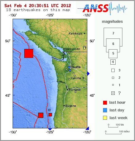
Not liking the looks of this map...
earthquake.usgs.gov...
It's like looking at a RISK board.. red army white army and blue army all converging on the yellow domain!
earthquake.usgs.gov...
Magnitude
3.0
Date-Time
Saturday, February 04, 2012 at 21:36:28 UTC
Saturday, February 04, 2012 at 01:36:28 PM at epicenter
Location
36.551°N, 121.136°W
Depth
8.6 km (5.3 miles)
Region
CENTRAL CALIFORNIA
Distances
2 km (1 miles) NNE (17°) from Pinnacles, CA
22 km (14 miles) NE (53°) from Soledad, CA
27 km (17 miles) NNE (21°) from Greenfield, CA
38 km (24 miles) N (359°) from King City, CA
40 km (25 miles) SE (145°) from Hollister, CA
111 km (69 miles) SE (142°) from San Jose City Hall, CA
Location Uncertainty
horizontal +/- 0.1 km (0.1 miles); depth +/- 0.3 km (0.2 miles)
Parameters
Nph= 62, Dmin=6 km, Rmss=0.09 sec, Gp= 43°,
M-type=duration magnitude (Md), Version=1
Source
California Integrated Seismic Net:
USGS Caltech CGS UCB UCSD UNR
Event ID
nc71724500
earthquake.usgs.gov...
It's like looking at a RISK board.. red army white army and blue army all converging on the yellow domain!
Magnitude
3.0
Date-Time
Saturday, February 04, 2012 at 21:36:28 UTC
Saturday, February 04, 2012 at 01:36:28 PM at epicenter
Location
36.551°N, 121.136°W
Depth
8.6 km (5.3 miles)
Region
CENTRAL CALIFORNIA
Distances
2 km (1 miles) NNE (17°) from Pinnacles, CA
22 km (14 miles) NE (53°) from Soledad, CA
27 km (17 miles) NNE (21°) from Greenfield, CA
38 km (24 miles) N (359°) from King City, CA
40 km (25 miles) SE (145°) from Hollister, CA
111 km (69 miles) SE (142°) from San Jose City Hall, CA
Location Uncertainty
horizontal +/- 0.1 km (0.1 miles); depth +/- 0.3 km (0.2 miles)
Parameters
Nph= 62, Dmin=6 km, Rmss=0.09 sec, Gp= 43°,
M-type=duration magnitude (Md), Version=1
Source
California Integrated Seismic Net:
USGS Caltech CGS UCB UCSD UNR
Event ID
nc71724500
earthquake.usgs.gov...
edit on 4-2-2012 by berkeleygal because: (no reason given)
Okay - I'm getting creeped out
Source
Round and Round we go - it's all over the place
Source
Magnitude 5.3
Date-Time Saturday, February 04, 2012 at 21:50:51 UTC
Sunday, February 05, 2012 at 01:50:51 AM at epicenter
Location 13.068°N, 57.535°E
Depth 10 km (6.2 miles)
Region OWEN FRACTURE ZONE REGION
Distances 443 km (275 miles) E (84°) from Qalansiyah, Socotra Island, Yemen
576 km (358 miles) SE (139°) from Salalah, Oman
1179 km (732 miles) S (186°) from MUSCAT, Oman
Location Uncertainty horizontal +/- 15.8 km (9.8 miles); depth +/- 2.8 km (1.7 miles)
Parameters NST=112, Nph=113, Dmin=>999 km, Rmss=1.17 sec, Gp= 72°,
M-type=regional moment magnitude (Mw), Version=4
Source Magnitude: USGS NEIC (WDCS-D)
Location: USGS NEIC (WDCS-D)
Event ID usb0007vzk
Source
Round and Round we go - it's all over the place
MAP 5.3 2012/02/04 21:50:51 13.068 57.535 10.0 OWEN FRACTURE ZONE REGION
MAP 5.7 2012/02/04 20:05:32 48.867 -127.876 12.8 VANCOUVER ISLAND, CANADA REGION
MAP 5.4 2012/02/04 19:29:22 11.986 125.718 54.9 SAMAR, PHILIPPINES
MAP 5.1 2012/02/04 18:01:47 0.815 -26.709 13.5 CENTRAL MID-ATLANTIC RIDGE
MAP 5.2 2012/02/04 17:45:30 -17.180 167.742 16.4 VANUATU
MAP 5.6 2012/02/04 13:09:23 11.899 125.757 10.7 SAMAR, PHILIPPINES
MAP 5.8 2012/02/04 07:40:13 -20.529 -174.025 10.0 TONGA
MAP 5.4 2012/02/04 04:09:36 42.311 105.608 9.6 CENTRAL MONGOLIA
MAP 5.1 2012/02/04 02:54:23 24.701 122.723 120.6 TAIWAN REGION
Source
edit on 4-2-2012 by Anmarie96 because: (no reason given)
reply to post by Anmarie96
Yeah, that's really weird. I can't remember the last time I saw so many bigger ones on one single day and so wide spread.
Maybe one of the pros here can enlighten us a bit more
Yeah, that's really weird. I can't remember the last time I saw so many bigger ones on one single day and so wide spread.
Maybe one of the pros here can enlighten us a bit more
reply to post by Anmarie96
Wanna hear something really creepy?
This quake:
Is pretty darned close to the antipodal point of the quake you just posted...and has the same magnitude (initially)
Wanna hear something really creepy?
This quake:
Magnitude 5.3
Date-Time Wednesday, February 01, 2012 at 21:43:48 UTC Wednesday, February01,2012at 02:43:48PM at epicenter Time of Earthquakein otherTimeZones
Location 31.380°S, 111.416°W
Depth 10.1 km (6.3 miles)
Region EASTER ISLAND REGION
Distances 507 km (315 miles) SSW of Hanga Roa, Easter Island 1957 km (1216 miles) ESE of ADAMSTOWN, Pitcairn Islands 2498 km (1552 miles) ESE of Rikitea, Mangareva, FrenchPolynesia 3816 km (2371 miles) W of SANTIAGO, Region Metropolitana, Chile
Location Uncertainty horizontal+/- 24.4 km (15.2 miles);depth +/- 2.9km (1.8miles)
Parameters NST=145, Nph=145, Dmin=513.2 km, Rmss=0.72 sec, Gp= 94°, M-type=body wave magnitude (Mb), Version=4
Source Magnitude: USGSNEIC (WDCS-D) Location: USGSNEIC (WDCS-D)
Event ID usb0007u9a
Is pretty darned close to the antipodal point of the quake you just posted...and has the same magnitude (initially)
It's clustering. As you have watched over the last week or so, you will have noticed there was a lull not to long ago. I was very tense. Because
stress was building. We first has PNG speak up followed by Vanuata. Then Japan etc.
If you look mainly at the 5+ list, on average, there's 3-5 per day. Not including aftershocks when you get something around 7M. During that lull, there was only one 5+M at Vanuata on Jan 31. Today there's been nine and as you've all noticed, there popping up in different areas all within a short timeframe. Since I am obsessed with the Eastern US quakes, I've been noticing this clustering for a long while now. The same thing happens globally. I will not even speculate on what I think is the cause. 'Cause I know the cause. Just kidding.
If you look at the Juan De Fuca plate. There were three quakes within roughtly an hour period- on different parts of the big slab of earth they call a plate.
In the Eastern US, it's been still super quiet. Texas the first whiff that a new cluster will start. The quakes left on the shake map are nearly a week old an will dissappear soon. When it's quiet that's when I watch the most. Because then you can follow how the clustering developes.
shh
And the list goes on...
EMSC
Magnitude M 5.3
Region KEPULAUAN KAI, INDONESIA
Date time 2012-02-05 00:05:56.0 UTC
Location 5.52 S ; 133.86 E
Depth 2 km
Distances 591 km SE Sorong (pop 125,535 ; local time 09:05:56.0 2012-02-05)
125 km E Tual (pop 39,502 ; local time 09:05:56.0 2012-02-05)
EMSC
and on...
EMSC
Magnitude mb 5.8
Region VANUATU
Date time 2012-02-05 00:15:41.0 UTC
Location 18.91 S ; 169.06 E
Depth 158 km
Distances 992 km W Suva (pop 199,455 ; local time 12:15:41.2 2012-02-05)
152 km SE Vila (pop 35,901 ; local time 11:15:41.2 2012-02-05)
73 km NW Isangel (pop 1,437 ; local time 11:15:41.2 2012-02-05)
EMSC
reply to post by wasobservingquietly
I did....and I usually take these with a grain of salt, However; this was a little cryptic and what have you, so I thought I would jump right into their delusions
But there might be something to that madness!
I did....and I usually take these with a grain of salt, However; this was a little cryptic and what have you, so I thought I would jump right into their delusions
But there might be something to that madness!
Hmm, this quake:
USGS
Is very close to the antipodes for these quakes:
USGS
Think I'll stop now...I'm probably wrong anyway
Magnitude
5.1
Date-Time
Saturday, February 04, 2012 at 18:01:46 UTC
Saturday, February 04, 2012 at 04:01:46 PM at epicenter
Time of Earthquake in other Time Zones
Location
0.815°N, 26.709°W
Depth
13.5 km (8.4 miles)
Region
CENTRAL MID-ATLANTIC RIDGE
Distances
818 km (508 miles) NE of Fernando de Noronha, Pernambuco, Brazil
1194 km (741 miles) NE of Natal, Rio Grande do Norte, Brazil
1337 km (830 miles) NE of Recife, Pernambuco, Brazil
1598 km (992 miles) SSW of PRAIA, Cape Verde
Location Uncertainty
horizontal +/- 22.1 km (13.7 miles); depth +/- 6.8 km (4.2 miles)
Parameters
NST= 92, Nph= 92, Dmin=>999 km, Rmss=0.73 sec, Gp=112°,
M-type=body wave magnitude (Mb), Version=5
Source
Magnitude: USGS NEIC (WDCS-D)
Location: USGS NEIC (WDCS-D)
Event ID
usb0007vv9
USGS
Is very close to the antipodes for these quakes:
Earthquake List for 10-degree Map Centered at 5°S, 150°E
Update time = Sun Feb 5 05:00:01 UTC 2012
MAP 5.1 2012/02/03 11:26:47 -6.722 150.082 12.6 NEW BRITAIN REGION, PAPUA NEW GUINEA
MAP 5.5 2012/02/02 09:32:15 -6.607 149.813 28.7 NEW BRITAIN REGION, PAPUA NEW GUINEA
MAP 5.0 2012/02/02 09:16:18 -5.294 153.550 74.0 NEW IRELAND REGION, PAPUA NEW GUINEA
USGS
Think I'll stop now...I'm probably wrong anyway
edit on 4-2-2012 by jadedANDcynical because: Fixed linkies
and then
Source
and then, ?
Magnitude 5.0
Date-Time Sunday, February 05, 2012 at 06:10:39 UTC
Sunday, February 05, 2012 at 09:40:39 AM at epicenter
Time of Earthquake in other Time Zones
Location 28.568°N, 51.471°E
Depth 10.1 km (6.3 miles)
Region SOUTHERN IRAN
Distances 76 km (47 miles) SE of Bushehr, Iran
111 km (68 miles) WSW of Firuzabad, Iran
117 km (72 miles) S of Kazerun, Iran
788 km (489 miles) S of TEHRAN, Iran
Location Uncertainty horizontal +/- 14.9 km (9.3 miles); depth +/- 1.6 km (1.0 miles)
Parameters NST= 80, Nph= 84, Dmin=618.9 km, Rmss=0.59 sec, Gp= 58°,
M-type=body wave magnitude (Mb), Version=5
Source Magnitude: USGS NEIC (WDCS-D)
Location: USGS NEIC (WDCS-D)
Event ID usb0007w4w
Source
and then, ?
I know what all that means... TOTAL SUPER UBER DOOM, RIGHT???
No? Awwwwwwww
No? Awwwwwwww
edit on 5-2-2012 by Vitchilo because: (no reason given)
reply to post by Vitchilo
Just a sitting here wondering if those Russian Scientist broke through the ice all that might explain a whole number of things - anyone hearing anything this evening?
Just a sitting here wondering if those Russian Scientist broke through the ice all that might explain a whole number of things - anyone hearing anything this evening?
Speaking of Russians...
USGS
Magnitude 5.2
Date-Time
* Sunday, February 05, 2012 at 07:10:18 UTC
* Sunday, February 05, 2012 at 01:10:18 PM at epicenter
* Time of Earthquake in other Time Zones
Location 41.434°N, 74.807°E
Depth 20.9 km (13.0 miles)
Region KYRGYZSTAN
Distances 99 km (61 miles) W of Naryn, Kyrgyzstan
161 km (100 miles) ENE of Jalal-Abad, Kyrgyzstan
161 km (100 miles) S of BISHKEK (Frunze), Kyrgyzstan
197 km (122 miles) ENE of Osh, Kyrgyzstan
Location Uncertainty horizontal +/- 14.7 km (9.1 miles); depth +/- 5.3 km (3.3 miles)
Parameters NST=133, Nph=133, Dmin=400.8 km, Rmss=0.67 sec, Gp= 65°,
M-type=body wave magnitude (Mb), Version=7
Source
* Magnitude: USGS NEIC (WDCS-D)
Location: USGS NEIC (WDCS-D)
Event ID usb0007w54
USGS
Magnitude mb 5.7
Region VANUATU
Date time 2012-02-05 16:40:45.8 UTC
Location 17.82 S ; 167.28 E
Depth 40 km
Distances 1180 km W Suva (pop 199,455 ; local time 04:40:45.8 2012-02-06)
109 km W Vila (pop 35,901 ; local time 03:40:45.8 2012-02-06)
EMSC
ETA: Upgraded to 6.3 !!
edit on 5-2-2012 by Hellas because: (no reason given)
Magnitude mb 5.5
Region CELEBES SEA
Date time 2012-02-05 16:46:58.0 UTC
Location 5.03 N ; 123.25 E
Depth 212 km
Distances 241 km SW Koronadal (pop 125,502 ; local time 00:46:58.1 2012-02-06)
186 km SW Kiamba (pop 10,979 ; local time 00:46:58.1 2012-02-06)
167 km SW Palimbang (pop 4,858 ; local time 00:46:58.1 2012-02-06)
EMSC
Magnitude mb 5.1
Region MICHOACAN, MEXICO
Date time 2012-02-05 17:01:10.0 UTC
Location 18.62 N ; 101.24 W
Depth 51 km
Distances 122 km S Morelia (pop 592,797 ; local time 11:01:10.1 2012-02-05)
38 km W Huetamo (pop 21,899 ; local time 11:01:10.1 2012-02-05)
33 km NW Zirándaro (pop 3,663 ; local time 11:01:10.1 2012-02-05)
EMSC
new topics
-
This is our Story
General Entertainment: 51 minutes ago -
President BIDEN Vows to Make Americans Pay More Federal Taxes in 2025 - Political Suicide.
2024 Elections: 3 hours ago -
Ode to Artemis
General Chit Chat: 3 hours ago -
Ditching physical money
History: 7 hours ago -
One Flame Throwing Robot Dog for Christmas Please!
Weaponry: 7 hours ago -
Don't take advantage of people just because it seems easy it will backfire
Rant: 7 hours ago -
VirginOfGrand says hello
Introductions: 8 hours ago -
Should Biden Replace Harris With AOC On the 2024 Democrat Ticket?
2024 Elections: 9 hours ago -
University student disciplined after saying veganism is wrong and gender fluidity is stupid
Education and Media: 11 hours ago
top topics
-
Hate makes for strange bedfellows
US Political Madness: 17 hours ago, 20 flags -
University student disciplined after saying veganism is wrong and gender fluidity is stupid
Education and Media: 11 hours ago, 12 flags -
Police clash with St George’s Day protesters at central London rally
Social Issues and Civil Unrest: 14 hours ago, 9 flags -
President BIDEN Vows to Make Americans Pay More Federal Taxes in 2025 - Political Suicide.
2024 Elections: 3 hours ago, 8 flags -
TLDR post about ATS and why I love it and hope we all stay together somewhere
General Chit Chat: 15 hours ago, 7 flags -
Should Biden Replace Harris With AOC On the 2024 Democrat Ticket?
2024 Elections: 9 hours ago, 6 flags -
Don't take advantage of people just because it seems easy it will backfire
Rant: 7 hours ago, 4 flags -
One Flame Throwing Robot Dog for Christmas Please!
Weaponry: 7 hours ago, 4 flags -
God lived as a Devil Dog.
Short Stories: 13 hours ago, 3 flags -
Ditching physical money
History: 7 hours ago, 3 flags
active topics
-
Police clash with St George’s Day protesters at central London rally
Social Issues and Civil Unrest • 37 • : SprocketUK -
New whistleblower Jason Sands speaks on Twitter Spaces last night.
Aliens and UFOs • 48 • : baablacksheep1 -
Russia Ukraine Update Thread - part 3
World War Three • 5718 • : Freeborn -
Hate makes for strange bedfellows
US Political Madness • 40 • : 19Bones79 -
Lawsuit Seeks to ‘Ban the Jab’ in Florida
Diseases and Pandemics • 29 • : Cre8chaos79 -
TLDR post about ATS and why I love it and hope we all stay together somewhere
General Chit Chat • 8 • : Cre8chaos79 -
This is our Story
General Entertainment • 0 • : BrotherKinsMan -
British TV Presenter Refuses To Use Guest's Preferred Pronouns
Education and Media • 126 • : Asher47 -
Why to avoid TikTok
Education and Media • 17 • : mooncake -
The Superstition of Full Moons Filling Hospitals Turns Out To Be True!
Medical Issues & Conspiracies • 22 • : mooncake