It looks like you're using an Ad Blocker.
Please white-list or disable AboveTopSecret.com in your ad-blocking tool.
Thank you.
Some features of ATS will be disabled while you continue to use an ad-blocker.

Quake Watch 2012
page: 33share:
VANUATU - are we there yet
I was going to put those aftershocks of the 2/2/2012 Mag 7.27Mwp (geoau finalized) quake into my Southern Vanuatuswarm series package, but it looks like its not over yet
This is what I have forswarm series number 8 so far;
I don't do 4's on that blog but these are them for those who are interested............
data used from USGS
Swarms might not be the correct term, some of them are swarms and some are aftershock series. I might go in and change that word
I was going to put those aftershocks of the 2/2/2012 Mag 7.27Mwp (geoau finalized) quake into my Southern Vanuatu
This is what I have for
7.1 2/02/2012 13:34 -17.766 167.134 23.1 VANUATU
5.3 2/02/2012 13:57 -17.462 167.169 10 VANUATU
5.0 2/02/2012 16:04 -17.779 167.233 33.3 VANUATU
5.5 2/02/2012 17:27 -17.963 167.209 22.8 VANUATU
5.2 2/02/2012 17:28 -17.596 167.339 20.8 VANUATU
5.1 2/02/2012 19:44 -17.457 167.229 31.9 VANUATU
5.1 2/02/2012 20:26 -17.519 167.359 17.4 VANUATU
6.0 3/02/2012 3:46 -17.376 167.278 21.7 VANUATU
5.4 3/02/2012 4:33 -17.484 167.232 23.8 VANUATU
5.7 3/02/2012 6:01 -17.38 167.183 24.9 VANUATU
5.2 4/02/2012 17:45 -17.18 167.742 16.4 VANUATU
6.1 5/02/2012 0:15 -18.935 168.923 163.4 VANUATU* a bit further south
5.0 5/02/2012 2:16 -17.435 167.13 20.9 VANUATU
6.0 5/02/2012 16:40 -17.95 167.17 4.3 VANUATU
I don't do 4's on that blog but these are them for those who are interested............
4.8 2/02/2012 10:44 -17.872 168.434 147.2 VANUATU
4.9 2/02/2012 13:53 -17.597 167.191 13.4 VANUATU
4.9 2/02/2012 19:20 -17.996 167.828 10.3 VANUATU
4.8 2/02/2012 21:47 -17.523 167.235 9.9 VANUATU
4.9 3/02/2012 8:13 -17.953 167.817 18.5 VANUATU
4.8 3/02/2012 14:25 -17.884 167.789 32.9 VANUATU
4.7 3/02/2012 15:05 -17.858 167.952 34.9 VANUATU
4.9 5/02/2012 2:27 -17.219 167.165 18.6 VANUATU
data used from USGS
Swarms might not be the correct term, some of them are swarms and some are aftershock series. I might go in and change that word
I've been watching (in GEE) 4 of the plate boundary borehole seismos off the Pacific Northwest, and noticed that the amplitute scales have all taken
a nosedive during the past hour. For instance, B036 was ranging between 390-310 ns/m. Now it is ranging from 270-190 nm/s.
Is this caused by ocean tides? I did check the NOAA tide site, and high tide nearest this station peaked 1-1/2 hours ago, but this station is inland 100km.
Anybody out there watch these with regularity? I'm just curious as to what causes the scale to plummet so.
Is this caused by ocean tides? I did check the NOAA tide site, and high tide nearest this station peaked 1-1/2 hours ago, but this station is inland 100km.
Anybody out there watch these with regularity? I'm just curious as to what causes the scale to plummet so.
further to post by muzzy
I just had to do a draft map for my own satisfaction, the USGS Map of the area just doesn't cut it I'm afraid
heres mine 5+ only
Vanuatu Series 8
It doesn't look as bad on the map does it
It would look worse if USGS were consistant and converted ALL the 6's to Mw,
that first 6 is still in mb
the 6.1 is Mw, with a 5.4mb reading in the phase data
the last 6 is Mw, but in the phase data is also 6.0mb
.................... so logically the first one should be more than 6.1Mw, based on the 2nd one
what has logic got to do with it eh
ETA;
just to confirm what I'm saying about converting to Mw
GFZ have that first 6.0mb one at 6.2Mw
edit on 5-2-2012 by muzzy because: (no reason given)
more on post by muzzy
its amazing what difference depth makes on those LISS graphs
I seen the Vanuatu 6.1 last night and thought, thats not a 6.1
Then this morning in comes a 6.0 which has a bigger trace even though its further away from SNZO
its the depth difference of course ( and a head smack)
LISS SNZO 05-02-2012 2048
edit on 5-2-2012 by muzzy because: (no reason given)
mb 5.5
Region FIJI REGION
Date time 2012-02-05 23:49:53.0 UTC
Location 19.54 S ; 177.52 W
Depth 33 km
Distances 454 km E Suva (pop 199,455 ; local time 11:49:53.2 2012-02-06)
299 km NW Nuku'alofa (pop 23,611 ; local time 12:49:53.2 2012-02-06)
198 km SE Tubou (pop 578 ; local time 11:49:53.2 2012-02-06)
EMSC
Folks, apologies if this has been brought up. I remember reading concerns about earthquake predicting. I posted this also at the new Cascadia thread.
In cases like Cascadia and the Great Tohoku EQ, subduction zones, I believe there may be a possible indicator of eminent EQ. Its known that the Tohoku
quake was preceded by a swarm. Swarm knowledge is limited as its a recent science. But it is possible that swarm activity signaled the recent 5.7M
quake off BC. see for swarm old.pnsn.org...
This initial swarm was started at 1AM on the 4th with the center of the swarm at approximately 48.9 lat and 123.8 long. These tremors are probably caused by the leading edge of the Juan de Fuca plate as it subducts under the North American plate. This would be the area that has subducted and is beginning to melt and break free from the plate, moving into the asthenosphere.
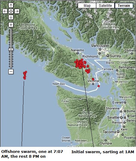
At 7:07 AM a slow slip tremor occurred east of the swarm at 48.6 lat and 125.9 long. At 8:05 PM, a 5.7M hit at 48.8 lat and 127.8 long. This was then followed 7 minutes later with some more slow slip activity occurring at the site of the 7:07 tremor, with only one slow slip tremor occurring at the original onshore swarm site from this point on.
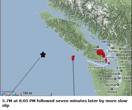
The main swarm was at 123.8 long, the mid swarm at 125.9 long, and the main quake at 127.8 long. A coincidence? Maybe yes, maybe no. I can't remember a pattern like this but it's only been recently that Ive been following swarms. I'm pretty sure the mid swarm is a foreshock with later aftershocks starting right after the main quake.
It might be worth checking to see if this pattern of a tear or slow slip occurring mid way between a swarm and the main quake has happened before.
This initial swarm was started at 1AM on the 4th with the center of the swarm at approximately 48.9 lat and 123.8 long. These tremors are probably caused by the leading edge of the Juan de Fuca plate as it subducts under the North American plate. This would be the area that has subducted and is beginning to melt and break free from the plate, moving into the asthenosphere.
At 7:07 AM a slow slip tremor occurred east of the swarm at 48.6 lat and 125.9 long. At 8:05 PM, a 5.7M hit at 48.8 lat and 127.8 long. This was then followed 7 minutes later with some more slow slip activity occurring at the site of the 7:07 tremor, with only one slow slip tremor occurring at the original onshore swarm site from this point on.
The main swarm was at 123.8 long, the mid swarm at 125.9 long, and the main quake at 127.8 long. A coincidence? Maybe yes, maybe no. I can't remember a pattern like this but it's only been recently that Ive been following swarms. I'm pretty sure the mid swarm is a foreshock with later aftershocks starting right after the main quake.
It might be worth checking to see if this pattern of a tear or slow slip occurring mid way between a swarm and the main quake has happened before.
edit on 5-2-2012 by zworld because: (no reason given)
edit on 5-2-2012 by zworld because: (no reason given)
reply to post by Olivine
Well you find out, and then we'll all know. Every time I ask this question to pros, I get ignored. I mean completely ignored. Like I never even asked the question at all. That's making TA very suspicious. Big surprise there, huh?
I will say this though. There is automatic compensation, calibration and centering for this in some software. That much, I AM sure of. So that could be one reason they don't care. Also, many of the newer instruments can be remotely centered with calibration pulses. But I've seen this very thing occur in a huge number of instruments. All of a sudden it just starts taking off, in a slow but steady decline or incline, causing the scales to get greatly off center.
Also, it could be that GEE itself is doing it for some reason. And from a bit of newer perspective here lately, I suspect that even more.
reply to post by TrueAmerican
Thanks for your input, TrueAmerican. I'll try to find an answer.
Low tide just passed, and the 4 boreholes I'm watching are climbing the scales. I'm going to watch for a few days, do some reading on the topic, and also monitor barometric pressure. If I find a viable correlation, I'll let you know.
Thanks for your input, TrueAmerican. I'll try to find an answer.
Low tide just passed, and the 4 boreholes I'm watching are climbing the scales. I'm going to watch for a few days, do some reading on the topic, and also monitor barometric pressure. If I find a viable correlation, I'll let you know.
Ok, we got an incoming, somewhere near southern Pacific/Guam, Java, not sure, but it's pretty good size it seems.
Watch USGS.
Yeppers. 6.8
earthquake.usgs.gov...
Watch USGS.
Yeppers. 6.8
earthquake.usgs.gov...
edit on Sun Feb 5th 2012 by TrueAmerican because: (no reason
given)
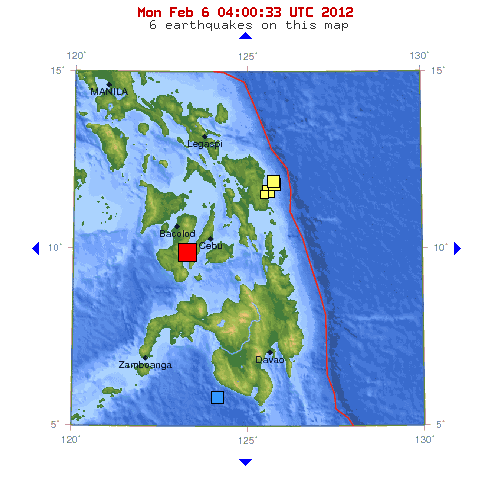
Magnitude 6.8 - NEGROS - CEBU REGION, PHILIPPINES
Date-Time
Monday, February 06, 2012 at 03:49:16 UTC
Monday, February 06, 2012 at 11:49:16 AM at epicenter
Location
9.964°N, 123.246°E
Depth
46.6 km (29.0 miles)
Region
NEGROS - CEBU REGION, PHILIPPINES
Distances
72 km (44 miles) N of Dumaguete, Negros, Philippines
74 km (45 miles) WNW of Tagbilaran, Bohol, Philippines
80 km (49 miles) WSW of Cebu, Cebu, Philippines
569 km (353 miles) SSE of MANILA, Philippines
USGS EMSC
EMSC is saying 6.9 now, and showing 46.6 km depth on USGS.
edit on 5/2/12 by murkraz because: (no reason given)
Originally posted by berkeleygal
earthquake.usgs.gov...
Im back in Canada for work and talking to wife via skype in Cebu when that one went off....she ran outside and i was praying i wasn't going to see the house collapse from the inside in real time.
heavy rains there im sure there will be landslides triggered, waiting to here reports.
Is that sub-duction there? Seems to be a ways away from the fault line.
I'm in the Philippines and there was not much damage. The 6.8 lasted around 30 secons and only one child died when a concrete fence of a house
collapsed in Taysan town. A mall in San Carlos city was damaged when its windows were shattered by the shaking. That's basicly it.
source(earthquake.usgs.gov...
TextMagnitude 6.2 Date-Time Monday, February 06, 2012 at 10:10:24 UTC Monday, February 06, 2012 at 06:10:24 PM at epicenter Time of Earthquake in other Time Zones Location 9.835°N, 123.131°E Depth 35.4 km (22.0 miles) Region NEGROS - CEBU REGION, PHILIPPINES Distances 60 km (37 miles) NNW of Dumaguete, Negros, Philippines 82 km (50 miles) WNW of Tagbilaran, Bohol, Philippines 94 km (58 miles) SSE of Bacolod, Negros, Philippines 578 km (359 miles) SSE of MANILA, Philippines Location Uncertainty horizontal +/- 15.6 km (9.7 miles); depth +/- 3 km (1.9 miles) Parameters NST= 88, Nph= 88, Dmin=407.4 km, Rmss=1.91 sec, Gp= 50°, M-type=regional moment magnitude (Mw), Version=7 Source Magnitude: USGS NEIC (WDCS-D) Location: USGS NEIC (WDCS-D) Event ID usb0007wiv
source(ph.news.yahoo.com...
TextAt least seven people were killed in the 6.9-magnitude quake that struck parts of the Visayas, authorities said. Bernadette Raidan, 8, and Anafe Estrabella, 11, were among the seven fatalities of the quake in Negros Oriental. Both were pinned down by a collapsed concrete, the National Disaster Risk Reduction and Management Council (NDRRMC) said in its update. NDRRMC said northern parts of the Negros Oriental registered severe damages in structures. A barangay hall also collapsed and cracks were also found in government and commercial buildings, roads and bridges in Guihulngan City. There were some"surface cracks" as well in RSB Building, Abellana National School, and in St. Vincent Gen. Hospital in Cebu City, NDRRMC said.
edit on 6-2-2012 by diamondsmith because:
add
reply to post by The Great Day
Not easy to locate the fault lines in the Philippines. The government officials here are more occupied finding ways of steeling peoples money than looking for faultlines.
Anyway, the quakes is not that far from Kanlaon Volcano (50-60 kilometer), one of the most active in Central Philippines, who had it's last VEI 2 eruption in June 03,2006.
No damage by the last one M-6.2 at 10:10:24 UTC, but as diamondsmith posted, there are some more casualties.
The M.6.9 affected a total of 59 areas including Dumaguete City and Tayasan, Negros Oriental, which felt the quake at Intensity 7.
edit on 6/2/2012 by Roald because: Had to ad
a link to a photo from the area.
This is not good,
source(www.emsc-csem.org...
TextMagnitude mb 5.9 Region NEGROS- CEBU REG, PHILIPPINES Date time 2012-02-06 11:33:38.7 UTC Location 10.00 N ; 123.02 E Depth 10 km Distances 22 km E Kabankalan (pop 136,483 ; local time 19:33:38.7 2012-02-06) 19 km E Su-ay (pop 19,672 ; local time 19:33:38.7 2012-02-06) 8 km NE Carol-an (pop 6,321 ; local time 19:33:38.7 2012-02-06)
reply to post by diamondsmith
No it's not good...not good at all. PuterMan will get cross with me for posting this link...but it is an external report and worth considering
"February 5, 2012 – MANILA, Philippines – The Philippine Institute of Volcanology and Seismology (Phivolcs) denied under water volcanoes caused the series of earthquakes in the Eastern Visayas starting Saturday night. This, as Phivolcs Director Renato Solidum Jr. pacified fears that volcanoes there would erupt anytime soon. Text messages started spreading last night that an underwater volcano is on the verge of erupting. This will supposedly cause a large tsunami. Local radio stations have already denied the information. Authorities there also said the information is untrue. A total of 70 aftershocks were recorded in the area ever since a magnitude 5.9 was recorded in the southeastern part of San Policarpio in Eastern Samar. Solidum told ABS-CBNnews.com that the cause of the earthquake was due to subduction. According to the US Geological Survey, subduction is the process of the oceanic lithosphere colliding with and descending beneath the continental lithosphere. No casualties have been recorded so far. – with a report from Geron Ponferra, ABS-CBN News Eastern Visayas. -ABS"
and that's before the 6.9...hmmm...maybe they will have to re-evaluate?
theextinctionprotocol.wordpress.com... hocks-rattle-sea-floor/
Rainbows
Jane
reply to post by angelchemuel
Also from your source,
source(theextinctionprotocol.wordpress.com...
TextFebruary 5, 2012 – PHILIPPINES – The Philippines, like Japan, sits in one of the most volatile tectonic areas on Earth but unlike Japan, the Philippines is under geological assault from plate movements on all sides. The Philippine plate is squeezed in between the Eurasian plate and the Pacific Plate, but the situation is more complex than that. The Philippine Islands are surrounded by complex plate boundaries, and the Philippines Plate rather consists of several micro-plates – squeezed in between two convergent plate margins. The lines with black triangles are active subduction zones with teeth on the over-riding plate.
new topics
-
Hurt my hip; should I go see a Doctor
General Chit Chat: 20 minutes ago -
Israel attacking Iran again.
Middle East Issues: 1 hours ago -
Michigan school district cancels lesson on gender identity and pronouns after backlash
Education and Media: 1 hours ago -
When an Angel gets his or her wings
Religion, Faith, And Theology: 2 hours ago -
Comparing the theology of Paul and Hebrews
Religion, Faith, And Theology: 3 hours ago -
Pentagon acknowledges secret UFO project, the Kona Blue program | Vargas Reports
Aliens and UFOs: 4 hours ago -
Boston Dynamics say Farewell to Atlas
Science & Technology: 4 hours ago -
I hate dreaming
Rant: 5 hours ago -
Man sets himself on fire outside Donald Trump trial
Mainstream News: 6 hours ago -
Biden says little kids flip him the bird all the time.
Politicians & People: 7 hours ago
top topics
-
The Democrats Take Control the House - Look what happened while you were sleeping
US Political Madness: 7 hours ago, 17 flags -
In an Historic First, In N Out Burger Permanently Closes a Location
Mainstream News: 9 hours ago, 15 flags -
A man of the people
Medical Issues & Conspiracies: 15 hours ago, 10 flags -
Biden says little kids flip him the bird all the time.
Politicians & People: 7 hours ago, 8 flags -
Man sets himself on fire outside Donald Trump trial
Mainstream News: 6 hours ago, 7 flags -
Pentagon acknowledges secret UFO project, the Kona Blue program | Vargas Reports
Aliens and UFOs: 4 hours ago, 6 flags -
Michigan school district cancels lesson on gender identity and pronouns after backlash
Education and Media: 1 hours ago, 4 flags -
4 plans of US elites to defeat Russia
New World Order: 16 hours ago, 4 flags -
Sheetz facing racial discrimination lawsuit for considering criminal history in hiring
Social Issues and Civil Unrest: 7 hours ago, 3 flags -
Israel attacking Iran again.
Middle East Issues: 1 hours ago, 3 flags
active topics
-
A man of the people
Medical Issues & Conspiracies • 14 • : chr0naut -
British TV Presenter Refuses To Use Guest's Preferred Pronouns
Education and Media • 68 • : ToneD -
MULTIPLE SKYMASTER MESSAGES GOING OUT
World War Three • 48 • : annonentity -
MH370 Again....
Disaster Conspiracies • 9 • : WakeUpBeer -
Israel attacking Iran again.
Middle East Issues • 17 • : visitedbythem -
Michigan school district cancels lesson on gender identity and pronouns after backlash
Education and Media • 7 • : Vermilion -
Elites disapearing
Political Conspiracies • 34 • : annonentity -
Hurt my hip; should I go see a Doctor
General Chit Chat • 1 • : Bluntone22 -
Vogt and the twelve thousand year cycle
Fragile Earth • 29 • : annonentity -
The Democrats Take Control the House - Look what happened while you were sleeping
US Political Madness • 65 • : lilzazz