It looks like you're using an Ad Blocker.
Please white-list or disable AboveTopSecret.com in your ad-blocking tool.
Thank you.
Some features of ATS will be disabled while you continue to use an ad-blocker.

At last, The "Watergate" Of 9/11 :
page: 8share:
reply to post by Evanvoid
Yes. Long story short. labtop started this thread saying the FDR data was fake because it showed AA77 leaving from a gate other than D26. After a long and difficult study he figured out that AA77 left from gate D26.
Next he is going to spend a lot of time figuring out that radar altitude only works at low altitudes.
In this post by "weedwhacker", in this thread,
Overwhelming Evidence Pentagon Aircraft Data Is Not From An American Airlines 757
www.abovetopsecret.com...
"weedwhacker" explained the fast-align procedure from own experience :
His text aligns perfectly with the three screenshots of the "fast align procedure" by Boeing in their cockpit procedures that I posted a few pages back.
From the moment I posted that small pack of Boeing cockpit information on the PfT site, Balsamo turned from reasonably friendly to viciously opposite.
He still did not change anything at his website regarding this conclusive evidence that Flight A77 in fact did leave from the southern Gate D26 at Dulles IAP on 9/11.
He is still holding on to a northern gate departure, instead of the right, southern D26 gate departure.
And this is even more puzzling, since all the Gate D26-evidence I laid before you in the last 2 pages is all based exclusively on the few investigations made by himself and especially all the work done by his PfT member "tumetuestumefaisdubien".
Balsamo's behavior now shows a clear decisive line of misrepresentation of facts.
Overwhelming Evidence Pentagon Aircraft Data Is Not From An American Airlines 757
www.abovetopsecret.com...
"weedwhacker" explained the fast-align procedure from own experience :
Also....on the ground, and stopped, there is an option for a "fast align". This, after a full align has occurred....you may select the knob to "ALIGN", and then re-input position coordinates. Then back to "NAV". It will update that IRU (you can do one, or any of them as desired) in about a minute .... usually less.
On occasion, I have done this many times....at the gate, when there is a long delay, unexpected. You've already aligned, but you are unexpectedly delayed....and the IRUs can "drift"....quite a bit, actually. It's just a fact that some are more "tight" than others....so, a fast align "cleans" them up a bit. Still, you must not be moving. Any time the selector is taken out of "NAV", position alignment....where it "thinks" it is, is lost.
His text aligns perfectly with the three screenshots of the "fast align procedure" by Boeing in their cockpit procedures that I posted a few pages back.
From the moment I posted that small pack of Boeing cockpit information on the PfT site, Balsamo turned from reasonably friendly to viciously opposite.
He still did not change anything at his website regarding this conclusive evidence that Flight A77 in fact did leave from the southern Gate D26 at Dulles IAP on 9/11.
He is still holding on to a northern gate departure, instead of the right, southern D26 gate departure.
And this is even more puzzling, since all the Gate D26-evidence I laid before you in the last 2 pages is all based exclusively on the few investigations made by himself and especially all the work done by his PfT member "tumetuestumefaisdubien".
Balsamo's behavior now shows a clear decisive line of misrepresentation of facts.
For those still not fully understanding the meat of the matter (Pilots for Truth included) :
It is clear by now, that not all what appears in, and was recorded in the FDR, for a read-out of it after any possible flight accident, does appear as a severe warning in real time on the cockpit instruments.
The substantial mis-alignment of the plane's position, registered in the FDR, build up over a long time in the subsequent FDR-records of each flight, did not trigger warnings on the cockpit's instruments.
In other words, the FDR does not trigger an alert warning to clean up the exact real-time position of the plane, after its recorded positions are shifted more and more after every flight.
If the 10 miles (8 NM) boundaries of the air ways are not crossed by the "positional drift" recorded in the FDR.
Thus the FDR interpreter must calculate the real position afterwards, just as I and "tumetuestumefaisdubien" had to do.
However, "tumetuestumefaisdubien" did not dare to implement the obvious first full align after the short distance gate pull-out and the following 7 fast aligns during stops while taxiing, in his diagram.
Perhaps Jan Zelman doesn't risk to be banned from PfT? He still needs aeronautical assistance? He can get that here in an honest manner, much better.
The 2004 Jeppesen Chart for KIAD/IAD Dulles Airport :
Full img : files.abovetopsecret.com...
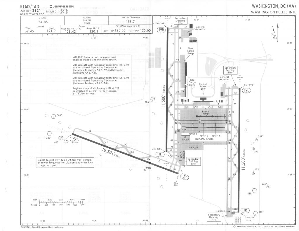
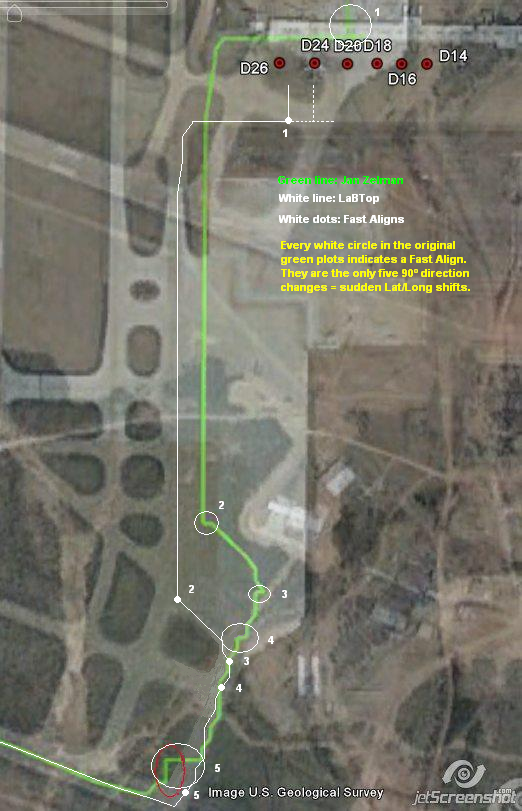
The following map is again the totally corrected image of the gate D26 departure, followed by taxiing and then take-off by Flight AA77 that later impacted the west wall of the Pentagon.
It shows 1 full align near the gate and seven fast aligns while waiting in the taxi lane towards Runway 30 :
This is what happened :
The Captain and his FO (Flight Officer) entered the cockpit in the morning, then were pushed back from Gate D26 by the ramper truck and pushed 180° back east so that the cockpit then faced west towards direction Runway 30.
They started the engines a bit too early and then performed a full align after the ramper coupled off. That's the first big map-shift (a 90° impossible turn, thus indicative of a fast align) that I showed on the map as number 1, near Gate D26.
Then they moved westwards and taxied a small distance along the opposite side of the parking area in front of Concourse D its south side, and after about hundred meters they turned left and southwards on the west side of the G and H Ramp, which is a taxi lane area, to follow the western boundary of the parking/resting and De-icing Ramp areas. There's a white line painted on the taxi lane as a "guide rail" to follow towards the runway.
When they reached the south end of that large Hold Block area, they stopped and executed their first fast align (one 90° ghost turn).
Map shift errors can be detected by comparing the position of the airplane on the HSI map with data from the ILS, VOR, DME and ADF systems (VOR is just 100 m south of Runway 30). Which the Flight AA77 pilots obviously did before they executed their fast aligns. That was in fact the reason they did that. (See drift in time, later described and explained)
Then they went on southeast, still following the white line on the western boundaries of the taxi lane along the Secondary Deicing Site area, stopped again on the corner and performed their second fast align (one 90° ghost turn), while waiting for clearance to proceed. On the way down they executed two more fast aligns (two 90° ghost turns), the third and fourth ones.
Then they moved on near to the corner of the taxi lane with Runway 30, and performed their fifth, sixth and final seventh fast align while much longer waiting again (three 90° ghost turns).
A much longer wait, otherwise that longest sudden shift in position is not explainable by drift in time.
After that they got clearance from Dulles tower, rolled on to Runway 30 and took off from IAD, Washington Dulles INTL Airport.
It is clear by now, that not all what appears in, and was recorded in the FDR, for a read-out of it after any possible flight accident, does appear as a severe warning in real time on the cockpit instruments.
The substantial mis-alignment of the plane's position, registered in the FDR, build up over a long time in the subsequent FDR-records of each flight, did not trigger warnings on the cockpit's instruments.
In other words, the FDR does not trigger an alert warning to clean up the exact real-time position of the plane, after its recorded positions are shifted more and more after every flight.
If the 10 miles (8 NM) boundaries of the air ways are not crossed by the "positional drift" recorded in the FDR.
Thus the FDR interpreter must calculate the real position afterwards, just as I and "tumetuestumefaisdubien" had to do.
However, "tumetuestumefaisdubien" did not dare to implement the obvious first full align after the short distance gate pull-out and the following 7 fast aligns during stops while taxiing, in his diagram.
Perhaps Jan Zelman doesn't risk to be banned from PfT? He still needs aeronautical assistance? He can get that here in an honest manner, much better.
The 2004 Jeppesen Chart for KIAD/IAD Dulles Airport :
Full img : files.abovetopsecret.com...
The following map is again the totally corrected image of the gate D26 departure, followed by taxiing and then take-off by Flight AA77 that later impacted the west wall of the Pentagon.
It shows 1 full align near the gate and seven fast aligns while waiting in the taxi lane towards Runway 30 :
This is what happened :
The Captain and his FO (Flight Officer) entered the cockpit in the morning, then were pushed back from Gate D26 by the ramper truck and pushed 180° back east so that the cockpit then faced west towards direction Runway 30.
They started the engines a bit too early and then performed a full align after the ramper coupled off. That's the first big map-shift (a 90° impossible turn, thus indicative of a fast align) that I showed on the map as number 1, near Gate D26.
Then they moved westwards and taxied a small distance along the opposite side of the parking area in front of Concourse D its south side, and after about hundred meters they turned left and southwards on the west side of the G and H Ramp, which is a taxi lane area, to follow the western boundary of the parking/resting and De-icing Ramp areas. There's a white line painted on the taxi lane as a "guide rail" to follow towards the runway.
When they reached the south end of that large Hold Block area, they stopped and executed their first fast align (one 90° ghost turn).
Map shift errors can be detected by comparing the position of the airplane on the HSI map with data from the ILS, VOR, DME and ADF systems (VOR is just 100 m south of Runway 30). Which the Flight AA77 pilots obviously did before they executed their fast aligns. That was in fact the reason they did that. (See drift in time, later described and explained)
Then they went on southeast, still following the white line on the western boundaries of the taxi lane along the Secondary Deicing Site area, stopped again on the corner and performed their second fast align (one 90° ghost turn), while waiting for clearance to proceed. On the way down they executed two more fast aligns (two 90° ghost turns), the third and fourth ones.
Then they moved on near to the corner of the taxi lane with Runway 30, and performed their fifth, sixth and final seventh fast align while much longer waiting again (three 90° ghost turns).
A much longer wait, otherwise that longest sudden shift in position is not explainable by drift in time.
After that they got clearance from Dulles tower, rolled on to Runway 30 and took off from IAD, Washington Dulles INTL Airport.
By now it is also clear that a 3000 + feet dis-alignment in the FDR certainly did not show up on the cockpit instruments as an alert.
That would have triggered (real-time connected) safety programs to flash red warnings in that cockpit.
Like the EICAS message "UNABLE RNP" that would have been flashed on the cockpit instrument panel, warning the pilots that alignment was out of its allowed wide boundaries (its value expressed in nautical miles ).
ACTUAL navigation performance (ANP) should not exceed RNP (REQUIRED navigation performance).
The FMC triggers the EICAS message UNABLE RNP to alert the flight crew if ANP exceeds RNP.
REQUIRED navigation performance (RNP) values have been created and published for certain areas of operation and procedures. The RNP, expressed in nautical miles, defines the accuracy of the navigation equipment required to fly the route or procedure for which it is published.
ACTUAL navigation performance is also expressed in nautical miles. It represents the radius of a circle centered at the FMC position which defines the limit of the potential error in that position. The smaller the ANP the more accurate the FMC position.
You can find yourself, all of this in Boeing's flight crew training manuals.
In the same thread linked to above, at page 14 (worth reading it all), ATS member "reheat" posted this very logical explanation :
Followed by another "reheat" explanation in another post on the same page :
The Boeing 757-200/300 Flight Crew Training Manual - RNP and RNAV Operations, provides this explanation nowadays for positional drift and how to correct it :
www.biggles-software.com...
The Biggles software represent the policy of a particular airline (Monarch, in the UK).
It seems to me, that these procedures were also in use on 9/11, except the GPS possibilities, which were not present in the 9/11 commercially flown planes. And were used after 2003, when the non-military used GPS satellite system was at last in place and operating.
That would have triggered (real-time connected) safety programs to flash red warnings in that cockpit.
Like the EICAS message "UNABLE RNP" that would have been flashed on the cockpit instrument panel, warning the pilots that alignment was out of its allowed wide boundaries (its value expressed in nautical miles ).
ACTUAL navigation performance (ANP) should not exceed RNP (REQUIRED navigation performance).
The FMC triggers the EICAS message UNABLE RNP to alert the flight crew if ANP exceeds RNP.
REQUIRED navigation performance (RNP) values have been created and published for certain areas of operation and procedures. The RNP, expressed in nautical miles, defines the accuracy of the navigation equipment required to fly the route or procedure for which it is published.
ACTUAL navigation performance is also expressed in nautical miles. It represents the radius of a circle centered at the FMC position which defines the limit of the potential error in that position. The smaller the ANP the more accurate the FMC position.
You can find yourself, all of this in Boeing's flight crew training manuals.
In the same thread linked to above, at page 14 (worth reading it all), ATS member "reheat" posted this very logical explanation :
He (Balsamo) obviously believes by showing what appears to be a large position error on the ground at Dulles IAP and then a more accurate position during flight that the IRU was realigned during flight. The equipment in Airline use are not capable of alignment during flight. Some military type units are. Therefore, he's implying there was a substitute aircraft (aircraft swap) at Dulles. It is all poppycock, pure and simple.
I will address the military units as I have considerable experience with them. Weedwhacker will address the Airline units. There is no such thing as auto-align during flight. Military unit capable of alignment in-flight take hours, not minutes to align. Even then they will be miles in error after a long MANAGED alignment procedure. They need very precise updates during this process usually provided by high resolution Attack Radar. It takes considerable time to do this and the results are not very accurate if it will even complete successfully.
AA 77 automatically updated the IRU during flight as it's designed to do becoming more accurate as the flight progressed. By the time the aircraft reached the Pentagon it was in the vicinity of some 200' in error. There is NO WAY in hell that unit was aligned in flight, period. Those in use by the Airlines are not capable and those high quality units in use by the military would not be capable during that period of time and they would not be even close to 200' to the actual position at the end. I hope this helps.
Followed by another "reheat" explanation in another post on the same page :
You still are not understanding an ALIGNMENT versus UPDATES. They are two different things altogether. An alignment occurs on the ground and initializes the unit to a location/position on the surface of the earth. Then accelerometers and gyros detect movement and display that as a position from the original aligned position.
After airborne the units UPDATE their position automatically with either VOR/DME or DME/DME (look up these via google) to control drift and refine the position already present in the units. In other words, the UPDATES cause them to be more precise over time.
Read this: en.wikipedia.org...
If you can recall GPS was not in wide use in 2001. I believe only B-1's and B-2's did have GPS in the aircraft for use in programming precision guided GPS type bombs. I do know of any other aircraft who had GPS at that time. Selective Availability (SA) was removed in 2000, but to my knowledge no airline had GPS in use by 2001. Also, there were no WAAS satellites at that time, so it was not practical for the airlines to spend the huge cost in implementing GPS until WAAS was turned on in 2003.
Read about SA here: en.wikipedia.org...
Read about WAAS here: en.wikipedia.org...
Don't despair. If you still don't understand after this and after reading those articles we'll try again. As Weedwhacker said it's difficult to "dumb down" this stuff for the layman.
The Boeing 757-200/300 Flight Crew Training Manual - RNP and RNAV Operations, provides this explanation nowadays for positional drift and how to correct it :
www.biggles-software.com...
The Biggles software represent the policy of a particular airline (Monarch, in the UK).
The FMC uses its calculated present position to generate lateral steering commands along the active leg to the active waypoint. The FMC requires position data from at least one IRS. All other position sources are validated against the IRS position and increase the accuracy of the FMC position.
FMC Position Update (Basic FMC)
On the ground, the FMC position is based on the IRS position.
Since inertial systems accumulate position errors as a function of time, the position information being used by the FMC is slowly accumulating errors. These position errors can be detected by observing the position of the airplane on the HSI map.
If an extended ground delay occurs and a significant map error is noticed the IRS should be realigned and present position re-entered.
As installed
When the autothrottle is engaged for takeoff, the FMC position is automatically updated to the takeoff runway position displayed on the TAKEOFF REF page.
In flight, the FMC position is continually updated from the navigation radios.
It seems to me, that these procedures were also in use on 9/11, except the GPS possibilities, which were not present in the 9/11 commercially flown planes. And were used after 2003, when the non-military used GPS satellite system was at last in place and operating.
This is in short words by "reheat", what's at the heart of the Dulles Gate D26 positional matter :
Reheat acts as a grumpy old man, but he certainly knows his facts.
Just as weedwhacker does.
Btw, what the hell would be wrong with being grumpy old men?
Heaps of stupidity, encountered in life and especially online, create grumpy old men.
If you can find the IRS-accuracy values in AA77 its FDR, you know the recorded amount of nautical miles the accumulated errors from all flights in that FDR have been.
We may suppose the LogBook from AA77 was onboard and lost in the crash.
This extensive post on page 16, by weedwhacker, neatly sums it all up :
www.abovetopsecret.com...
REQUIRED navigation performance (RNP), and yes, I found that even before I read your above excellent explanatory text. See start of this post.
Originally posted by Reheat
You still are not understanding an ALIGNMENT versus UPDATES. They are two different things altogether. An alignment occurs on the ground and initializes the unit to a location/position on the surface of the earth. Then accelerometers and gyros detect movement and display that as a position (LT: away) from the original aligned position.
After airborne the units UPDATE their position automatically with either VOR/DME or DME/DME (look up these via google) to control drift and refine the position already present in the units. In other words, the UPDATES cause them to be more precise over time.
It is simply not possible for the airline type to ALIGN in a position other than stationary, period.
Reheat acts as a grumpy old man, but he certainly knows his facts.
Just as weedwhacker does.
Btw, what the hell would be wrong with being grumpy old men?
Heaps of stupidity, encountered in life and especially online, create grumpy old men.
If you can find the IRS-accuracy values in AA77 its FDR, you know the recorded amount of nautical miles the accumulated errors from all flights in that FDR have been.
weedwhacker : Finally...as to the old, pre-GPS IRS "drift"...it was constantly correcting it (them)selves...and, to repeat for emphasis once more, the airplane referenced and displayed the "triple mix" average of all three units.
To keep an "eye" on the "health" of each individual unit, it was (still is) a requirement to log into the aircraft LogBook, end of every flight, the "IRS accuracy" readings.
(I would have thought that Rob Balsamo, and Ralph Kolstad, of all people, knew this......funny, they omit explaining in proper detail, isn't it???)
The units keep track of elapsed time they are in align mode, for each flight...and the average amount of MILES they calculated their accumulated errors to be. The hours of operation are divided into the average "drift", and those numbers are displayed on an info page, you access from the menu....and you write those figures into specific places, in the LogBook, designed to record the values.
We may suppose the LogBook from AA77 was onboard and lost in the crash.
This extensive post on page 16, by weedwhacker, neatly sums it all up :
www.abovetopsecret.com...
I am so glad I only devoted a small fraction of effort to the latest red herring from the "P4T" crowd....because, THIS is what it all boils down to, their (incredibly false and deceptive) claim:
There was a slight error in the FMC position relative to actual, physical airplane position, when on the ground at KIAD;
The John Farmer / FOIA / NTSB (etc) data show that the FMC position information "corrected" itself after takeoff;
THEREFORE ('they' allege) AAL 77 "could not" have been a real civilian airliner, since no commercial airliner of that time could do an INU system "alignment" in-flight.
Does that about sum it up??
What we NOW all know (I hope) are these facts:
---The FMC Position updating shown, after takeoff and in flight, is PERFECTLY NORMAL for all commercial civlian airplanes with an INU system (called the "IRS").
---The Map Shift (if even noticed, before takeoff) is an insignificant factor for a flight that operates on routes that do NOT require precision RNAV capability. (I haven't even begun to address the concept of "RNP" yet...I will just drop that hint, and let everyone do their own research on it....).
---The attempts by the so-called "Pilots" for so-called "Truth" to muddy the issue, the facts, the circumstances, the reality and use innuendo-dropping of the worst kind in order to further their twisted agenda? Despicable.
REQUIRED navigation performance (RNP), and yes, I found that even before I read your above excellent explanatory text. See start of this post.
iSunTzu explained it in best detail, in his post on top of page 17 :
Balsamo, you have been beaten with your own forum-posted facts.
And the aeronautical facts.
As long as you don't correct your main page and numerous other forum pages its info, regarding Flight 77 and its true departure gate D26, your credibility is zero.
Correct this main page : pilotsfor911truth.org...
Correct this main page too : pilotsfor911truth.org...
The "LATITUDE/LONGITUDE", the "DEPARTURE GATE AND FULL ALIGNMENT " and the "AUTO-ALIGNMENT AND GPS " and "CONCLUSION" texts.
You should be stopped in any legal way possible, still spreading this kind of blatantly wrong disinfo, now that you have this irrefutable evidence in front of you, and had it for many months already, send to you by me, even after you banned me. I still did give you a chance to correct your mistakes yourself, but you opted to be stubborn, again.
PS :
www.pilotsfor911truth.org...
Investigate the AA77 FDR values for these settings, when the plane was still on the ground at Dulles :
R_VOR_DATA_FAULT_CAPT,R_TANK_LB_KG,R_NAV_MODE_OPER,R_IRS_DATA_FAULT_CAPT,R_FMC_DATA_FAULT_CAPT,R_FCC_DATA_FAULT_CAPT,R_ADF_DATA_FAULT_CAPT
and these :
L_VOR_DATA_FAULT_CAPT,L_TANK_LB_KG,L_NAV_MODE_OPER,L_IRS_DATA_FAULT_CAPT,L_FMC_DATA_FAULT_CAPT,L_FCC_DATA_FAULT_CAPT,L_ADF_DATA_FAULT_CAPT
and these :
IRU_SELECTED__F_O,IRU_SELECTED__CAPT,IRU_FAULT,IRS_SELECT_SW_CAPT,IRS_MLS,IRS_LOC,IRS__R__MODE_OPER,IRS__L__MODE_OPER,IRS__C__MODE_OPER,IRS__3__MODE_O PER
and these :
C_IRS_DATA_FAULT_CAPT,C_FCC_DATA_FAULT_CAPT
ACTUAL_NAV_PERF__ANP__MSB,ACTUAL_NAV_PERF__ANP__LSB
The clue is in the three IRS systems, the left, center and right ones.
The rest just corroborates it. (f.ex. IRU_FAULT) Note also all FMC values.
And if you still struggle with the fault margins subject, read the excellent explanation by iSunTzu:
www.abovetopsecret.com...
www.abovetopsecret.com...
Originally posted by iSunTzu
reply to post by backinblack
Look it up. The FMS does not only use IRS data.
www.biggles-software.com...
This is just an overview, think of the details in the system.
A 3,000 foot error or more at take off in the IRS is not news, it is called reality.
Now what is recorded in the FDR is from the FMC, not only from an IRS. The FMC updates its position based on rules and algorithms. The FMS-FMC is seen auto-tuning DME after take off to update the FMC position. The FDR information proves the FMC was working. The only way to verify this is to learn more. There is no inside job on 911, 19 terrorists did it. Saying the FDR is not from 77 is a lie.
IRS alone, ANP is around 0.4 NM and drifts. This does not mean the position from IRS at take off can't be better than 2400 feet, it means that it is typical, and guess what? After a few minutes it drifts. IRS drifts at a rate ~0.8 NM/hr. Guess who keeps the "real" (best guess position) the aircraft is? FMC. The FMC can use VOR, DME, LOC, to update the position. The FMC keeps track of IRS errors, and can use the IRS to pick up navigation if other sources are lost. The FMC knows the IRS are drifting off, and can use them to navigate because it applies the errors to correct from that point, even if the IRS are off miles.
www.inral.com...
Not related to 77, but to how the FMC works.
77 had no GPS, else the FMC after take off would drift to perfection of 0.1 NM or better.
Drift, I meant the algorithm in the FMC refines/defines the position of the aircraft.
What do Pilots for Truth say the ANP for an IRS only is?
They can not, it will ruin their story.
There are many references to learn more about Nav :
www.vatnz.net...
boeing.com...
en.wikipedia.org...
boeing.com...
IRU and INS equipped airplanes are eligible to be qualified for time limited RNP-10 approval as Group 2 airplanes (8400.12A, Section 12, paragraph b) if they have inertial systems approved in accordance with part 121, Appendix G. Group 2 airplanes have limited qualification of the RNP-10 requirements for up to 6.2 hours of flight time. This time starts when the system is placed in the navigation mode. Following an automatic DME/DME update, a Group 2 airplane is again approved for 5.9 hours of flight time. Following an automatic DME/VOR update, a Group 2 airplane is again approved for 5.7 hours of flight time (8400.12A, Section 12, paragraph e.).
IRS that have drifted off are still good because the FMC can update with other systems and essentially start the IRS position "new", updated. The IRS are only good for a 10 mile accuracy to 6.2 hours, but the FMC can use other systems, update, and use IRS for another 5.9 hours. But the raw IRS is still way off.
Pilots don't taxi to the runway using IRS, we use a white line painted, like the yellow brick road. For takeoff we use our eyes and the ADI/HSI, plus a white-line. This is why we don't taxi to the grass where the IRS thinks it is, or the FMC showing the IRS position.
Balsamo, you have been beaten with your own forum-posted facts.
And the aeronautical facts.
As long as you don't correct your main page and numerous other forum pages its info, regarding Flight 77 and its true departure gate D26, your credibility is zero.
Correct this main page : pilotsfor911truth.org...
Text still disinformational, as per Sunday 2 Oktober :
After adjusting a Lat/Long offset based on drift prone to the navigational equipment utilized, the positional data has the aircraft departing a gate further east of Gate D26 and on the north side of the Concourse.
Correct this main page too : pilotsfor911truth.org...
The "LATITUDE/LONGITUDE", the "DEPARTURE GATE AND FULL ALIGNMENT " and the "AUTO-ALIGNMENT AND GPS " and "CONCLUSION" texts.
You should be stopped in any legal way possible, still spreading this kind of blatantly wrong disinfo, now that you have this irrefutable evidence in front of you, and had it for many months already, send to you by me, even after you banned me. I still did give you a chance to correct your mistakes yourself, but you opted to be stubborn, again.
PS :
www.pilotsfor911truth.org...
Investigate the AA77 FDR values for these settings, when the plane was still on the ground at Dulles :
R_VOR_DATA_FAULT_CAPT,R_TANK_LB_KG,R_NAV_MODE_OPER,R_IRS_DATA_FAULT_CAPT,R_FMC_DATA_FAULT_CAPT,R_FCC_DATA_FAULT_CAPT,R_ADF_DATA_FAULT_CAPT
and these :
L_VOR_DATA_FAULT_CAPT,L_TANK_LB_KG,L_NAV_MODE_OPER,L_IRS_DATA_FAULT_CAPT,L_FMC_DATA_FAULT_CAPT,L_FCC_DATA_FAULT_CAPT,L_ADF_DATA_FAULT_CAPT
and these :
IRU_SELECTED__F_O,IRU_SELECTED__CAPT,IRU_FAULT,IRS_SELECT_SW_CAPT,IRS_MLS,IRS_LOC,IRS__R__MODE_OPER,IRS__L__MODE_OPER,IRS__C__MODE_OPER,IRS__3__MODE_O PER
and these :
C_IRS_DATA_FAULT_CAPT,C_FCC_DATA_FAULT_CAPT
ACTUAL_NAV_PERF__ANP__MSB,ACTUAL_NAV_PERF__ANP__LSB
The clue is in the three IRS systems, the left, center and right ones.
The rest just corroborates it. (f.ex. IRU_FAULT) Note also all FMC values.
And if you still struggle with the fault margins subject, read the excellent explanation by iSunTzu:
www.abovetopsecret.com...
www.abovetopsecret.com...
waypastvne,
yes I know it is Radar Altitude, and its boundaries, but I do not understand why they do not program the FDR software to show ERROR, or Out_Of_Range, instead of repeating the last recorded true radar altitude, after it went out of range.
From Wikipedia, where they use both the term radio- and radar-altitude :
en.wikipedia.org...
yes I know it is Radar Altitude, and its boundaries, but I do not understand why they do not program the FDR software to show ERROR, or Out_Of_Range, instead of repeating the last recorded true radar altitude, after it went out of range.
edit on 2/10/11 by LaBTop because: Changed Radio to Radar.
From Wikipedia, where they use both the term radio- and radar-altitude :
Radar altimeters are frequently used by commercial aircraft for approach and landing, especially in low-visibility conditions (see instrument flight rules) and also automatic landings (autoland), allowing the autopilot to know when to begin the flare maneuver.
In civil aviation applications, radio altimeters generally only give readings up to 2,500 feet (760 m) above ground level (AGL).
en.wikipedia.org...
edit on 2/10/11 by LaBTop because: Added explanation for radio or radar altimeters.
reply to post by LaBTop
"Grumpy old man" am i? I'm only grumpy when dealing with ignorant conspiracy theorists who know nothing. I see that you've gained some knowledge since your many failures at analyzing the Pentagon scenario. You need to learn more and eventually you'll come to realize that both pfffft and CIT are lying to you with virtually every conclusion they draw.
Learn how to calculate a turn radius and you will immediate see what a fraud CIT is perpetuating with their North of Citgo crap. First of all, they lied about where Paik was located as AA 77 passed his shop. Second, reexamine Morin's words. Any flight path from Paik's location to the impact point at the Pentagon requires a minimum of 60-70 degrees of bank. None of the CIT witnesses described this. That type of bank by a large airliner would be unforgettable. That ought to give you a clue that something is wrong with their conclusion. All that those witnesses saw was AA 77 on the proven flight path, yet they misjudged the distance. The path is proven by 3 different radars and the kinetic energy damage path through the building.
As you are beginning to discover, the key to escaping the conspiracy theory mindset is knowledge. Knowledge will set you free from the crap. Continue to learn and you'll eventually see me as something other than a "grumpy old man".
edit on 3-10-2011 by Reheat because: (no reason given)
reply to post by Cassius666
Thank you! I don't hear this question addressed nearly enough. "If it wasn't an AA flight that crashed into the building(s), what happened to the actual aircraft and passengers?"
Thank you! I don't hear this question addressed nearly enough. "If it wasn't an AA flight that crashed into the building(s), what happened to the actual aircraft and passengers?"
First I need to re-post my last PS (post scriptum), since the forum software seems to have problems with a too long sentence with solely capitals,
underscores and comma's, without interruption by free spaces.
Here it is again :
PS :
www.pilotsfor911truth.org...
Investigate the AA77 FDR values for these settings, when the plane was still on the ground at Dulles :
R_VOR_DATA_FAULT_CAPT, R_NAV_MODE_OPER, R_IRS_DATA_FAULT_CAPT,
R_FMC_DATA_FAULT_CAPT, R_FCC_DATA_FAULT_CAPT, R_ADF_DATA_FAULT_CAPT,
and these :
L_VOR_DATA_FAULT_CAPT, L_NAV_MODE_OPER, L_IRS_DATA_FAULT_CAPT,
L_FMC_DATA_FAULT_CAPT, L_FCC_DATA_FAULT_CAPT, L_ADF_DATA_FAULT_CAPT,
and these :
IRU_SELECTED__F_O, IRU_SELECTED__CAPT, IRU_FAULT, IRS_SELECT_SW_CAPT,
IRS_MLS, IRS_LOC, IRS__R__MODE_OPER, IRS__L__MODE_OPER,
IRS__C__MODE_OPER, IRS__3__MODE_OPER,
and these :
C_IRS_DATA_FAULT_CAPT, C_FCC_DATA_FAULT_CAPT,
ACTUAL_NAV_PERF__ANP__MSB, ACTUAL_NAV_PERF__ANP__LSB,
The clue is in the three IRS systems, the left, center and right ones.
The rest just corroborates it. (f.ex. IRU_FAULT) Note also all FMC values.
And if you still struggle with the fault margins subject, read the excellent explanation by iSunTzu:
www.abovetopsecret.com...
www.abovetopsecret.com...
Reheat, it was a remark based on remembering with a big smile, that funny film "Grumpy Old Men".
I'm quite sure I am as old, but probably older than you, so yes, you can count me in for the same club of "grumpy" old men. My family and friends do indeed see me like that many times, but there is still a lot of silent love and mutual understanding left over, to keep me in balance with them and our personal happiness.
Now that we are at it, can we try to set the cards right for the SoC or NoC flight paths subject too? That is still a brick on my shoulders, and I want to get rid of it, one way or the other.
The moment I started to read your logical explanations based on your long aeronautical experience in that other thread I linked to above, I got interested in your signature link :
Debunking the North of Citgo Theory
www.911myths.com...
So I immediately read it.
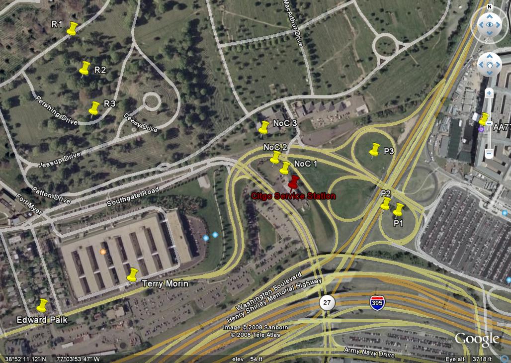
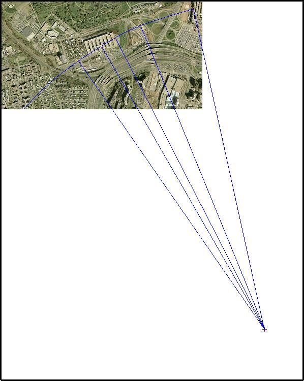
This is your diagram with the tags R1, R2, and R3 which are the center points of the turn radii for the Morin to NoC turns.
The tags P1, P2, and P3 are the center points of the turn radii for the NoC locations to the impact point at the Pentagon.
1.028px × 730px : www.911myths.com...
And I am quite puzzled by your placement of the centerpoints of your proposed arcs.
Why do you place the first set of three (R1,R2,R3), north of the witnesses? And so near?
You wrote yourself that Terry Morin said the plane followed a nearly straight line, only its tail tipped to the right when it disappeared behind the line of trees in the western front of the CITGO. That's a description of one slight right bank just at the CITGO, while in a very gentle arc, in my opinion. By someone with aeronautical experience, Terry Morin.
And the second set of three (P1,P2,P3), south of the witnesses? So near too?
That leads to a totally illogical and totally impossible sharp S-turn between Morin, the CITGO gas station and the impact point. But if you place your centerpoints all to the south of the witnesses and much further away, you would see that suddenly all is possible, like I did.
This is from my OpeningPost, my proposal for a large and VIABLE flight path arc, passing EXACTLY over ALL 4 of the North of CITGO witnesses positions unearthed by the CIT guys. Included Terry Morin at the Navy Annex building.
And from Edward Paik's position backwards (westwards, to the left side of my map) you have to think of a straighter line than that part of my blue arc-line, thus then connecting to the part of the real flightpath passing over the Golf Club grounds towards passing the south side of the Sheraton Hotel and then partly over the roof of the car repair shop from Edward Paik.
It's obvious that my single arc has a far greater radius, than the 2 short ones that you proposed in your signature link to your thesis, written by yourself.
Which positions are also corroborated by the earliest interviews of the same persons (a few months after 9/11) by the CMH (Center for Military History) interviewers and the Library of Congress interviewers :
Original Size 598px × 750px :
files.abovetopsecret.com...
This horizontal flightpath arc fits EXACTLY all known Pentagon attack plane's witness positions, and all their witness statements.
And especially all the impact sightings from those in a position to see them with their own eyes, for example all the drivers on Route 27 in front of the Pentagon west wall who said they saw a plane impact. Also the new NoC witnesses I found, the ones in the traffic jam, in front of the Helipad.
From west to east in my above viable flight path arc :
1. First western radius endpoint on the arc : Edward Paik at his garage near the Sheraton Hotel;
2. Second radius : Terry Morin, the guy between the 4th and 5th building of the Navy Annex;
3. Third radius : the Y-shaped antenna on top and at the center position on the roof of the Navy Annex 8th building, described by the Helipad tower operator, Sean Boger as the point where he saw the attack plane passed over; Albert Hemphill at his window at the right top floor end of the east side of the Navy Annex 8th building;
4. Fourth radius : Sgt. William Lagasse under the northern CITGO canopy; Sgt. Brooks across the road from the CITGO; Robert Turcios under the southern CITGO canopy;
After that fourth radius : all 5 Arlington National Cemetery workers; Vin Narayan, Penny Elgas and Christine Peterson in the north going center lane on Route 27 in front of the Helipad; Steve Riskus on the opposite south going lane looking at the north corner side of the Helipad; Levi in the furthest north western part of the South Parking Lot; Roosevelt Roberts 6 steps out from the South Loading Dock;
5. Fifth radius leads to the official and photographed impact point.
You and I probably will differ at first about the real position from Terry Morin, which I place 5 to 10 steps out of the door leading into the fifth wing of the Navy Annex (very near that small white line in the center between wing 4 and 5 on your map), on his way back to his car to pick up his clear lenses, after he saw that he brought only his sunglasses with him. That door is located in the center of that wing 5 building, that's important to note.
The space between wing 4 and 5 is broader than one would think, and there was a S-shaped footpath inbetween the grass and bushes on both sides. That's why he said he made a slight right turn towards the security check-in building just above Wing 4 . He did that on that small footpath, and not on the parking place just outside wing 4 and 5, as you and many with you seem to think based on his words in the interview you referrred to in your link.
He however made another recorded telephone call, where he was just a bit more precise about the spot he was at, when AA77 flew over him. And that's the 5 to 10 steps out from that 5th wing entrance door to the elevator hall, beside the 4 story corridor connection in the middle between wing 4 and 5.
If he really was already 10 steps outside from wing 4 and 5, he would have said that he turned around and saw the plane coming. But he said that he made a gentle RIGHT turn (on that S-shaped footpath), then heard the plane's noise behind him and to his LEFT, then turned to his LEFT, then immediately realized that the thundering sound of the engines cascaded back from the wall of the fifth wing, and then he saw its body passing over his head, while he was looking up from halfway inbetween those two Navy Annex wing buildings :
If he walked already away from the wings 4 and 5 buildings, and was already on his way over the parking lot towards the security check-in building, he only had to turn his head a tiny bit to his RIGHT to easily see the plane coming straight at him.
But he said he turned (his body) to the LEFT.
Because he heard the noise from BEHIND him, and to his LEFT. He was still inbetween the two buildings!
If he was were you think he was (your yellow placemarker pin on your map above), while already crossing the parking lot to the gate, he would have heard and seen the plane coming in full sight from his RIGHT. He would have looked the pilot in his eyes, so to say.
If you however imagine him just outside and beside the 4 story corridor connection in the middle between wing 4 and 5, then all he said above falls in place.
And when you listen to his second interview with the CIT guys, he even better explained where he was. I have posted quite a lot about the Terry Morin interviews years ago here, you'll have to look those up again for the links to his TWO interviews and my remarks then.
But his own words from that first interview you referred to and showed in your thesis says enough already.
To top it of, I would like to mention the two Pentagon Security police officers, Sgt. William Lagasse and Sgt. Brooks, who both swore that the plane flew north of the CITGO roof.
And I met William online before he got interviewed by the CIT crew, and he definitely was a rabient Official Story defender! That's why I believe him and his colleague.
They really heard and saw that plane flying north of the CITGO !
I'm quite sure I am as old, but probably older than you, so yes, you can count me in for the same club of "grumpy" old men. My family and friends do indeed see me like that many times, but there is still a lot of silent love and mutual understanding left over, to keep me in balance with them and our personal happiness.
Now that we are at it, can we try to set the cards right for the SoC or NoC flight paths subject too? That is still a brick on my shoulders, and I want to get rid of it, one way or the other.
The moment I started to read your logical explanations based on your long aeronautical experience in that other thread I linked to above, I got interested in your signature link :
Debunking the North of Citgo Theory
www.911myths.com...
So I immediately read it.
This is your diagram with the tags R1, R2, and R3 which are the center points of the turn radii for the Morin to NoC turns.
The tags P1, P2, and P3 are the center points of the turn radii for the NoC locations to the impact point at the Pentagon.
1.028px × 730px : www.911myths.com...
And I am quite puzzled by your placement of the centerpoints of your proposed arcs.
Why do you place the first set of three (R1,R2,R3), north of the witnesses? And so near?
You wrote yourself that Terry Morin said the plane followed a nearly straight line, only its tail tipped to the right when it disappeared behind the line of trees in the western front of the CITGO. That's a description of one slight right bank just at the CITGO, while in a very gentle arc, in my opinion. By someone with aeronautical experience, Terry Morin.
And the second set of three (P1,P2,P3), south of the witnesses? So near too?
That leads to a totally illogical and totally impossible sharp S-turn between Morin, the CITGO gas station and the impact point. But if you place your centerpoints all to the south of the witnesses and much further away, you would see that suddenly all is possible, like I did.
This is from my OpeningPost, my proposal for a large and VIABLE flight path arc, passing EXACTLY over ALL 4 of the North of CITGO witnesses positions unearthed by the CIT guys. Included Terry Morin at the Navy Annex building.
And from Edward Paik's position backwards (westwards, to the left side of my map) you have to think of a straighter line than that part of my blue arc-line, thus then connecting to the part of the real flightpath passing over the Golf Club grounds towards passing the south side of the Sheraton Hotel and then partly over the roof of the car repair shop from Edward Paik.
It's obvious that my single arc has a far greater radius, than the 2 short ones that you proposed in your signature link to your thesis, written by yourself.
Which positions are also corroborated by the earliest interviews of the same persons (a few months after 9/11) by the CMH (Center for Military History) interviewers and the Library of Congress interviewers :
Original Size 598px × 750px :
files.abovetopsecret.com...
This horizontal flightpath arc fits EXACTLY all known Pentagon attack plane's witness positions, and all their witness statements.
And especially all the impact sightings from those in a position to see them with their own eyes, for example all the drivers on Route 27 in front of the Pentagon west wall who said they saw a plane impact. Also the new NoC witnesses I found, the ones in the traffic jam, in front of the Helipad.
From west to east in my above viable flight path arc :
1. First western radius endpoint on the arc : Edward Paik at his garage near the Sheraton Hotel;
2. Second radius : Terry Morin, the guy between the 4th and 5th building of the Navy Annex;
3. Third radius : the Y-shaped antenna on top and at the center position on the roof of the Navy Annex 8th building, described by the Helipad tower operator, Sean Boger as the point where he saw the attack plane passed over; Albert Hemphill at his window at the right top floor end of the east side of the Navy Annex 8th building;
4. Fourth radius : Sgt. William Lagasse under the northern CITGO canopy; Sgt. Brooks across the road from the CITGO; Robert Turcios under the southern CITGO canopy;
After that fourth radius : all 5 Arlington National Cemetery workers; Vin Narayan, Penny Elgas and Christine Peterson in the north going center lane on Route 27 in front of the Helipad; Steve Riskus on the opposite south going lane looking at the north corner side of the Helipad; Levi in the furthest north western part of the South Parking Lot; Roosevelt Roberts 6 steps out from the South Loading Dock;
5. Fifth radius leads to the official and photographed impact point.
You and I probably will differ at first about the real position from Terry Morin, which I place 5 to 10 steps out of the door leading into the fifth wing of the Navy Annex (very near that small white line in the center between wing 4 and 5 on your map), on his way back to his car to pick up his clear lenses, after he saw that he brought only his sunglasses with him. That door is located in the center of that wing 5 building, that's important to note.
The space between wing 4 and 5 is broader than one would think, and there was a S-shaped footpath inbetween the grass and bushes on both sides. That's why he said he made a slight right turn towards the security check-in building just above Wing 4 . He did that on that small footpath, and not on the parking place just outside wing 4 and 5, as you and many with you seem to think based on his words in the interview you referrred to in your link.
He however made another recorded telephone call, where he was just a bit more precise about the spot he was at, when AA77 flew over him. And that's the 5 to 10 steps out from that 5th wing entrance door to the elevator hall, beside the 4 story corridor connection in the middle between wing 4 and 5.
If he really was already 10 steps outside from wing 4 and 5, he would have said that he turned around and saw the plane coming. But he said that he made a gentle RIGHT turn (on that S-shaped footpath), then heard the plane's noise behind him and to his LEFT, then turned to his LEFT, then immediately realized that the thundering sound of the engines cascaded back from the wall of the fifth wing, and then he saw its body passing over his head, while he was looking up from halfway inbetween those two Navy Annex wing buildings :
Approximately 10 steps out from between Wings 4 and 5, I was making a gentle right turn towards the security check-in building just above Wing 4 when I became aware of something unusual. I can’t remember exactly what I was thinking about at that moment, but I started to hear an increasingly loud rumbling behind me and to my left. As I turned to my left, I immediately realized the noise was bouncing off the 4-story structure that was Wing 5. One to two seconds later the airliner came into my field of view. By that time the noise was absolutely deafening. I instantly had a very bad feeling about this but things were happening very quickly. The aircraft was essentially right over the top of me and the outer portion of the FOB (flight path parallel the outer edge of the FOB).
If he walked already away from the wings 4 and 5 buildings, and was already on his way over the parking lot towards the security check-in building, he only had to turn his head a tiny bit to his RIGHT to easily see the plane coming straight at him.
But he said he turned (his body) to the LEFT.
Because he heard the noise from BEHIND him, and to his LEFT. He was still inbetween the two buildings!
If he was were you think he was (your yellow placemarker pin on your map above), while already crossing the parking lot to the gate, he would have heard and seen the plane coming in full sight from his RIGHT. He would have looked the pilot in his eyes, so to say.
If you however imagine him just outside and beside the 4 story corridor connection in the middle between wing 4 and 5, then all he said above falls in place.
And when you listen to his second interview with the CIT guys, he even better explained where he was. I have posted quite a lot about the Terry Morin interviews years ago here, you'll have to look those up again for the links to his TWO interviews and my remarks then.
But his own words from that first interview you referred to and showed in your thesis says enough already.
To top it of, I would like to mention the two Pentagon Security police officers, Sgt. William Lagasse and Sgt. Brooks, who both swore that the plane flew north of the CITGO roof.
And I met William online before he got interviewed by the CIT crew, and he definitely was a rabient Official Story defender! That's why I believe him and his colleague.
They really heard and saw that plane flying north of the CITGO !
reply to post by LaBTop
Read what Morin said... ALL OF IT! Not just the part you want to be true to make it fit your conspiracy. The center of the turn radius is dictated by the turn required. It is not arbitrary. Did you measure what appears to be a gentle arc to you from Paik to the impact point? The most gentle turn one can calculate requires 60 degrees of bank. Have you ever seen a huge airliner at 60 degrees of bank close to the ground? If you have you'd never forget it. Why did NOT ONE of these witnesses describe that type of bank?
You seem to be confused about witnesses. There were dozens. Many more than the cherry picked ones CIT uses for their nonsense. Then there are the 3 radars, the damage path both outside AND inside the building. Put all of that together and come up with a plausible reason WHY? conspirators would even attempt to fake such an elaborate plot. If you think with a rational mind for only a minute or two you'll realize how stupid it would be to go to all of the trouble and risk being seen or filmed performing all of the tasks to fake such a plot. Trimming a tree to the shape of an engine, knocking down lamp posts, skinning a camera pole, planting a wing tip piece in someones car are some of the things conspirators would have needed to do to fake a flight path. It only takes a few minutes to realize faking something that elaborate makes absolutely no sense whatsoever.
This is a link to one of my posts at PfT, with my links to lectures by Professor Trani, an aeronautical lecturer at a US university :
pilotsfor911truth.org...
So, yes, I know how to calculate turn radii, and a lot more.
But I am no wide body commercial airline pilot, so your help and expertise will be much appreciated.
Just as that from Weedwhacker, whatwasthat, and iSunTzu.
And for the FDR expertise, Warren Stutt and 911files (John Farmer?)
Originally posted by LaBTop
But I am no wide body commercial airline pilot, so your help and expertise will be much appreciated.
Just as that from Weedwhacker, whatwasthat, and iSunTzu.
And for the FDR expertise, Warren Stutt and 911files (John Farmer?)
Have you noticed what all of those mentioned above have in common?
This is a turn calculator :
www.csgnetwork.com...
When I enter 285 KTS (328.035 MPH) as the speed entering the turn, and 180 KTS (207.180 MPH) as a 757 its rated stall speed (a guess), and a bank angle of 15°, I get a turn radius of about 4.45 Nmiles (5.1 Miles).
Is that about the radius I used in my above viable flightpath arc?
When I change only the bank angle to your proposed 60°, I get a turn radius of only 0.8 miles (0.7 NM). I think my proposed turn radius is quite a bit longer.
Edit : When I change the bank angle to 30 °, the turn radius changes to 2.35 Miles.
edit on 3/10/11 by LaBTop because: Added 30° bank angle.
Originally posted by LaBTop
This is a turn calculator :
www.csgnetwork.com...
When I enter 285 KTS (328.035 MPH) as the speed entering the turn, and 180 KTS (207.180 MPH) as a 757 its rated stall speed (a guess), and a bank angle of 15°, I get a turn radius of about 4.45 Nmiles (5.1 Miles).
Is that about the radius I used in my above viable flightpath arc?
When I change only the bank angle to your proposed 60°, I get a turn radius of only 0.8 miles (0.7 NM). I think my proposed turn radius is quite a bit longer.
Edit : When I change the bank angle to 30 °, the turn radius changes to 2.35 Miles.
edit on 3/10/11 by LaBTop because: Added 30° bank angle.
First of all, in your diagram above you're North of the actual impact point at the Pentagon. You need to move that point to the South. From Paik's shop passing slightly North of the Citgo station, thence to the impact point the turn radius is about 5,540' or a little over 1 statute mile. At the slow speed of 285 Kts the bank required is about 53 degrees at 1.7 G's. That's a pretty slow speed, but still a very steep bank angle that NO ONE DESCRIBED..
The rated stall speed of a 757 in a clean configuration is 160 Kts.
edit on 3-10-2011 by Reheat because: (no reason given)
reply to post by RustyNailer
The initial prime suspect of any homicide investigation is someone the victim knew or who was closely related to the victim in some way. Even serial killers hardly ever travel interstate to commit a murder, but prefer to work close to their comfort zone.
excerpt from: www.fbi.gov...
Psychopathic "evil" serial murderers are rarely some exotic fanatic terrorist from a far away land, but are well integrated into the community, even possessing a front of being a patriot of some sort.
All insurance claims are initially assessed to determine if there is any grounds for suspicion of being bogus - i.e if the claimants themselves are purposeful perpetrators of the fire damage or whatever. Almost all claims of physical injury are investigated by undercover operatives who hope to catch the claimant out faking injuries by tailing them and catching them doing some heavy lifting etc.
The more complex the conspiracy and the greater the scale of a crime, the greater the inability to comprehend it by the masses.
In the bible somewhere it is written: "If thine eye offends thee, pluck it out." (probably before the corruption of a part defiles the whole) But what if the eye is the only uncorrupted part and the rest of the body is defiled? Better to believe that the eye is defiled and pluck out that innocent organ?
All your "evidence" is circumstantial. It's time to accept the cold hard reality that there are people out there who are evil and wish to do you harm. Maybe you have to tell yourselves that the GOV is out to get you because your mind can't except that fanatical religious psychopaths want to slaughter as many infidels as they can. Time to grow up people.
The initial prime suspect of any homicide investigation is someone the victim knew or who was closely related to the victim in some way. Even serial killers hardly ever travel interstate to commit a murder, but prefer to work close to their comfort zone.
excerpt from: www.fbi.gov...
Myth: All serial murderers travel and operate interstate.
Most serial killers have very defined geographic areas of operation. They conduct their killings within comfort zones that are often defined by an anchor point (e.g. place of residence, employment, or residence of a relative). Serial murderers will, at times, spiral their activities outside of their comfort zone, when their confidence has grown through experience or to avoid detection. Very few serial murderers travel interstate to kill
Psychopathic "evil" serial murderers are rarely some exotic fanatic terrorist from a far away land, but are well integrated into the community, even possessing a front of being a patriot of some sort.
Myth: Serial killers are all dysfunctional loners. The majority of serial killers are not reclusive, social misfits who live alone. They are not monsters and may not appear strange. Many serial killers hide in plain sight within their communities. Serial murderers often have families and homes, are gainfully employed, and appear to be normal members of the community. Because many serial murderers can blend in so effortlessly, they are oftentimes overlooked by law enforcement and the public.
All insurance claims are initially assessed to determine if there is any grounds for suspicion of being bogus - i.e if the claimants themselves are purposeful perpetrators of the fire damage or whatever. Almost all claims of physical injury are investigated by undercover operatives who hope to catch the claimant out faking injuries by tailing them and catching them doing some heavy lifting etc.
The more complex the conspiracy and the greater the scale of a crime, the greater the inability to comprehend it by the masses.
In the bible somewhere it is written: "If thine eye offends thee, pluck it out." (probably before the corruption of a part defiles the whole) But what if the eye is the only uncorrupted part and the rest of the body is defiled? Better to believe that the eye is defiled and pluck out that innocent organ?
The impact point is about right, I thought. I let the plane's right wing tip cross over the corner of the knocked down fence. But that is not very
sensitive in the turn radius and bank angle calculations.
I played around with the calculator, and the interesting thing is, that the stall speed is not very important for the bank angle change. However, the speed is to a far greater extend.
I agree, my turn radius seems to be a lot shorter than I thought in first instance. I was looking for the total length of the Navy Annex building, but could not find it (seems to be some military secret, smile). If we know that, then we can just measure it off with a pair of compasses. Do you know some landmark in my map, where we know the dimensions from ? I have my compasses at hand...
But it looks as if my radius is about 2.7 kilometer in length. I base that on my measurement of the width of the Pentagon lawn, from west wall to Route 27 in front of it, being about 110 meters wide. If you measure that off on my map, you find about 2.7 km for the radius.
If your bank angle of 53° is about right, than I do agree that I never ever heard one eyewitness mentioning such an extreme bank angle for AA77.
I like simple evidence, and this seems to me such simple proof.
I am still confused about the two Pentagon Police men.
How on earth could they have seen that plane flying so damn low, NORTH of their positions?
Especially Lagasse, who stood filling up his gas tank at the furthest northern gas pump, under the northern canopy!
He could not ever have seen a SoC flying plane and describe the window shades down, so close he must have been.
well, you guys can definitely rule out the pattern that included lloyde england's testimony, based on this video here........
www.thepentacon.com...
At about the 7:00 min point in this 24 minutes long video, Terry Morin tells us exactly where he was situated.
About 10 feet (3 meter) INSIDE between the two walls from wing 4 and 5.
Again another place than we both thought.
At about the 7:00 min point in this 24 minutes long video, Terry Morin tells us exactly where he was situated.
About 10 feet (3 meter) INSIDE between the two walls from wing 4 and 5.
Again another place than we both thought.
new topics
-
BIDEN Admin Begins Planning For January 2025 Transition to a New President - Today is 4.26.2024.
2024 Elections: 2 hours ago -
Big Storms
Fragile Earth: 4 hours ago -
Where should Trump hold his next rally
2024 Elections: 6 hours ago -
Shocking Number of Voters are Open to Committing Election Fraud
US Political Madness: 7 hours ago -
Gov Kristi Noem Shot and Killed "Less Than Worthless Dog" and a 'Smelly Goat
2024 Elections: 8 hours ago -
Falkville Robot-Man
Aliens and UFOs: 8 hours ago -
James O’Keefe: I have evidence that exposes the CIA, and it’s on camera.
Whistle Blowers and Leaked Documents: 9 hours ago -
Australian PM says the quiet part out loud - "free speech is a threat to democratic dicourse"...?!
New World Order: 10 hours ago -
Ireland VS Globalists
Social Issues and Civil Unrest: 10 hours ago -
Biden "Happy To Debate Trump"
2024 Elections: 11 hours ago
top topics
-
James O’Keefe: I have evidence that exposes the CIA, and it’s on camera.
Whistle Blowers and Leaked Documents: 9 hours ago, 17 flags -
Australian PM says the quiet part out loud - "free speech is a threat to democratic dicourse"...?!
New World Order: 10 hours ago, 15 flags -
Blast from the past: ATS Review Podcast, 2006: With All Three Amigos
Member PODcasts: 13 hours ago, 13 flags -
Biden "Happy To Debate Trump"
2024 Elections: 11 hours ago, 13 flags -
Ireland VS Globalists
Social Issues and Civil Unrest: 10 hours ago, 9 flags -
Mike Pinder The Moody Blues R.I.P.
Music: 13 hours ago, 8 flags -
Shocking Number of Voters are Open to Committing Election Fraud
US Political Madness: 7 hours ago, 6 flags -
BIDEN Admin Begins Planning For January 2025 Transition to a New President - Today is 4.26.2024.
2024 Elections: 2 hours ago, 6 flags -
What is the white pill?
Philosophy and Metaphysics: 12 hours ago, 6 flags -
RAAF airbase in Roswell, New Mexico is on fire
Aliens and UFOs: 11 hours ago, 5 flags
active topics
-
RAAF airbase in Roswell, New Mexico is on fire
Aliens and UFOs • 12 • : pianopraze -
BIDEN Admin Begins Planning For January 2025 Transition to a New President - Today is 4.26.2024.
2024 Elections • 14 • : WeMustCare -
A Warning to America: 25 Ways the US is Being Destroyed
New World Order • 29 • : 19Bones79 -
Big Storms
Fragile Earth • 15 • : Caver78 -
What is the white pill?
Philosophy and Metaphysics • 22 • : AlexandrosOMegas -
University of Texas Instantly Shuts Down Anti Israel Protests
Education and Media • 315 • : CriticalStinker -
Gov Kristi Noem Shot and Killed "Less Than Worthless Dog" and a 'Smelly Goat
2024 Elections • 58 • : cherokeetroy -
Biden "Happy To Debate Trump"
2024 Elections • 51 • : rickymouse -
Hate makes for strange bedfellows
US Political Madness • 53 • : 19Bones79 -
SETI chief says US has no evidence for alien technology. 'And we never have'
Aliens and UFOs • 79 • : SchrodingersRat