It looks like you're using an Ad Blocker.
Please white-list or disable AboveTopSecret.com in your ad-blocking tool.
Thank you.
Some features of ATS will be disabled while you continue to use an ad-blocker.

Quake Watch 2011
page: 374share:
After seeing the waveform (I pulled it up in GEE) and phase data of the Japan 5.3, that will probably be reduced down to the 4.9- 5.0 neighborhood.
But look where it happened:
earthquake.usgs.gov...
For more comments on this, see the latest post in The Final Warning to Tokyo thread here:
www.abovetopsecret.com...
earthquake.usgs.gov...
For more comments on this, see the latest post in The Final Warning to Tokyo thread here:
www.abovetopsecret.com...
edit on Wed Nov 16th 2011 by TrueAmerican because: (no reason given)
A little one in the UK AGAIN
2011/11/15 16:05:54.6 51.627 -3.571 7 1.5 MAESTEG,BRIDGEND
BGS
Rainbows
Jane
2011/11/15 16:05:54.6 51.627 -3.571 7 1.5 MAESTEG,BRIDGEND
BGS
Rainbows
Jane
reply to post by TrueAmerican
Thanks for the heads-up. I have posted one of my typically longish replies there , but at least it includes a little piece of referenced information that might be useful to some.
Mike
Thanks for the heads-up. I have posted one of my typically longish replies there , but at least it includes a little piece of referenced information that might be useful to some.
Mike
We had a little quake in the little old Czech Republic today. I'm posting it because it's not in a place where we so commonly seem to get them.
(Most of ours are either out west or up near the Polish border.)
Source: ESMC
Mike
Magnitude ML 2.2
Region CZECH REPUBLIC
Date time 2011-11-16 12:22:53.4 UTC
Location 50.45 N ; 14.12 E
Depth 10 km
Distances 47 km NW Prague (pop 1,167,050 ; local time 13:22:53.4 2011-11-16)
10 km W Roudnice nad labem (pop 13,075 ; local time 13:22:53.4 2011-11-16)
4 km W Doksany (pop 368 ; local time 13:22:53.4 2011-11-16)
Source: ESMC
Mike
reply to post by LorraineRKO
yes indeed
I didn't have time yesterday to check BMKG
*RS = Richter Scale, ie ML
I see EMSC have 5.8Mw, and there are a lot of 6 magnitudes on the phase data.
If I was collecting 6+ events I'd have that one
Interesting trace on my local station SNZO, looks like a butterfly , not sure what that means, perhaps it was two events
SNZO (Karori, NZ) 5406 km SE of epicenter
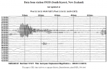
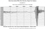
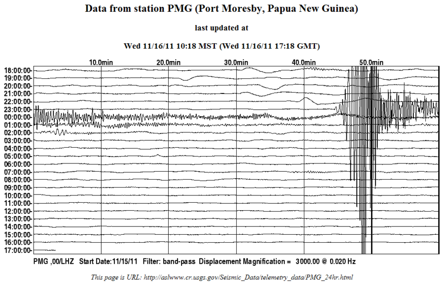
compare with the closest LISS station
PMG (Port Moresby, Papua New Guinea) 877.8 km ESE of the epicenter
yes indeed
I didn't have time yesterday to check BMKG
Date 16/11/2011-6:42:34 UTC+7
Magnitude 6.2 RS*
Depth 57 Km
Location 5.25 S 140.4 E
Information:
The quake's epicenter was on land 34 Southwest Oksibil
Felt (MMI):
III Tanah Merah, II Merauke, III Wamena, IV Oksibil, III Sumohai (Yahukimo),
*RS = Richter Scale, ie ML
I see EMSC have 5.8Mw, and there are a lot of 6 magnitudes on the phase data.
If I was collecting 6+ events I'd have that one
Interesting trace on my local station SNZO, looks like a butterfly , not sure what that means, perhaps it was two events
SNZO (Karori, NZ) 5406 km SE of epicenter

compare with the closest LISS station
PMG (Port Moresby, Papua New Guinea) 877.8 km ESE of the epicenter
edit on 16-11-2011 by muzzy because: (no reason given)
Small swarm off Nuhaka, south of Gisborne, NZ last night
Mag, Ref, Lat, Long, Date Time UTC, Depth, Felt
4.528, 3611452, -38.97795, 178.11513, 2011/11/16 7:18:41, 25, Felt
4.187, 3611491, -38.93253, 178.01563, 2011/11/16 7:28:46, 27, Felt
4.331, 3611453, -38.92346, 177.96118, 2011/11/16 7:29:10, 27, Felt
3.086, 3611463, -38.92896, 178.03899, 2011/11/16 7:43:1, 27, No
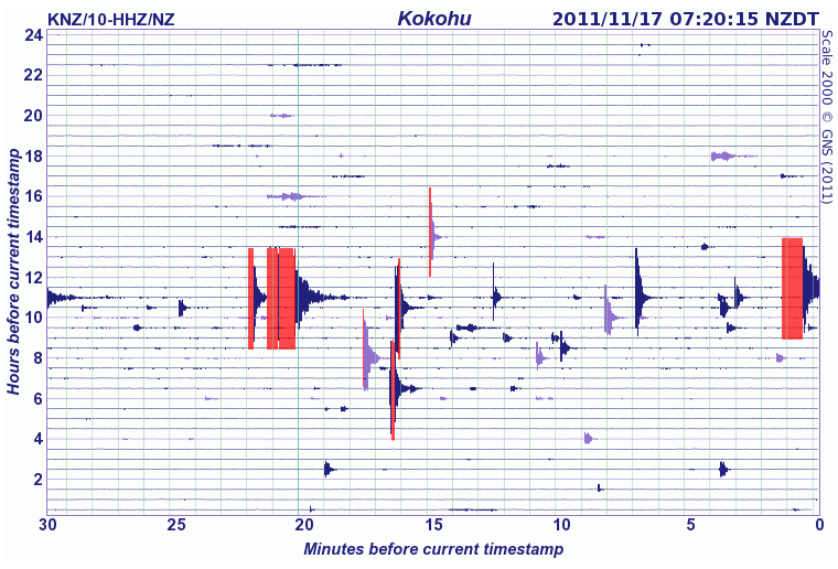
colourful graph on Urewera URZ HH1
closest Geonet station is KNZ (cropped)
3 quakes hit Gisborne within minutes - NZ Newswire
Mag, Ref, Lat, Long, Date Time UTC, Depth, Felt
4.528, 3611452, -38.97795, 178.11513, 2011/11/16 7:18:41, 25, Felt
4.187, 3611491, -38.93253, 178.01563, 2011/11/16 7:28:46, 27, Felt
4.331, 3611453, -38.92346, 177.96118, 2011/11/16 7:29:10, 27, Felt
3.086, 3611463, -38.92896, 178.03899, 2011/11/16 7:43:1, 27, No
colourful graph on Urewera URZ HH1
closest Geonet station is KNZ (cropped)
3 quakes hit Gisborne within minutes - NZ Newswire
edit on 16-11-2011 by muzzy because: (no reason given)
reply to post by muzzy
Muzzy is the Virgin Islands "swarm" normal? I know that Puerto Rico is usually active just saw these quakes and I am wondering if that many is the norm. Thx in advance.
Link..
I may have left a couple out I'm trying to post from my iPhone
Muzzy is the Virgin Islands "swarm" normal? I know that Puerto Rico is usually active just saw these quakes and I am wondering if that many is the norm. Thx in advance.
MAP 3.2 2011/11/15 19:53:06 18.870 -64.012 61.7
VIRGIN ISLANDS REGION MAP 3.3 2011/11/14 03:10:26 19.123 -64.068 49.0
VIRGIN ISLANDS REGION MAP 3.3 2011/11/14 02:28:05 19.097 -64.106 54.0
VIRGIN ISLANDS REGION MAP 2.8 2011/11/13 18:35:52 18.800 -63.965 61.2
VIRGIN ISLANDS REGION MAP 3.3 2011/11/13 11:11:38 18.852 -63.920 60.0
VIRGIN ISLANDS REGION MAP 2.9 2011/11/13 11:09:15 18.876 -64.185 74.0
VIRGIN ISLANDS REGION MAP 3.0 2011/11/13 09:49:17 18.830 -63.875 55.7
VIRGIN ISLANDS REGION MAP 2.8 2011/11/13 09:34:15 18.940 -63.967 59.9
VIRGIN ISLANDS REGION MAP 2.6 2011/11/13 09:18:16 19.073 -64.078 36.7
VIRGIN ISLANDS REGION MAP 3.1 2011/11/13 09:06:20 19.053 -63.959 52.5
VIRGIN ISLANDS REGION MAP 2.5 2011/11/13 07:43:21 19.263 -64.287 8.0
VIRGIN ISLANDS REGION MAP 3.2 2011/11/13 07:02:31 19.163 -64.173 41.5
VIRGIN ISLANDS REGION MAP 2.9 2011/11/13 06:54:19 19.027 -64.123 49.5
VIRGIN ISLANDS REGION MAP 2.5 2011/11/13 06:51:52 19.005 -64.150 54.5
VIRGIN ISLANDS REGION MAP 3.1 2011/11/13 06:31:40 19.088 -64.139 50.5
VIRGIN ISLANDS REGION MAP 3.4 2011/11/13 05:51:23 19.222 -64.210 45.8
VIRGIN ISLANDS REGION MAP 2.7 2011/11/13 05:05:15 18.943 -64.084 61.5
VIRGIN ISLANDS REGION MAP 3.1 2011/11/13 04:41:13 19.098 -64.178 58.2
VIRGIN ISLANDS REGION MAP 3.0 2011/11/13 04:28:16 19.005 -64.048 63.2
VIRGIN ISLANDS REGION MAP 3.2 2011/11/13 04:03:50 18.617 -63.896 55.2
VIRGIN ISLANDS REGION MAP 3.5 2011/11/13 03:45:02 19.212 -64.264 40.4
VIRGIN ISLANDS REGION MAP 3.1 2011/11/13 03:26:31 19.214 -64.203 49.7
VIRGIN ISLANDS REGION MAP 3.4 2011/11/13 03:05:24 18.998 -64.062 58.4
VIRGIN ISLANDS REGION MAP 3.4 2011/11/13 02:56:48 18.700 -63.909 59.0
VIRGIN ISLANDS REGION MAP 3.1 2011/11/13 02:33:28 19.199 -64.176 41.5
VIRGIN ISLANDS REGION MAP 2.6 2011/11/13 02:30:54 18.847 -63.997 56.0
VIRGIN ISLANDS REGION MAP 3.3 2011/11/13 02:13:56 19.041 -64.111 55.9
VIRGIN ISLANDS REGION MAP 3.1 2011/11/13 02:05:19 19.703 -64.177 49.1
VIRGIN ISLANDS REGION MAP 2.7 2011/11/13 02:02:58 18.779 -63.928 50.3
VIRGIN ISLANDS REGION MAP 3.1 2011/11/13 01:39:43 19.221 -64.262 9.9
VIRGIN ISLANDS REGION MAP 3.2 2011/11/13 01:26:43 19.139 -64.199 49.0
VIRGIN ISLANDS REGION MAP 2.5 2011/11/13 01:24:33 19.265 -64.242 9.8
VIRGIN ISLANDS REGION MAP 3.2 2011/11/13 01:23:08 19.163 -64.165 46.0
VIRGIN ISLANDS REGION MAP 3.6 2011/11/13 01:17:04 18.920 -64.009 60.3
VIRGIN ISLANDS REGION MAP 3.2 2011/11/13 01:01:39 19.198 -64.189 41.5
VIRGIN ISLANDS REGION MAP 3.4 2011/11/13 00:44:31 19.258 -64.243 40.4
VIRGIN ISLANDS REGION MAP 3.5 2011/11/13 00:33:18 19.476 -64.107 54.1
VIRGIN ISLANDS REGION MAP 3.2 2011/11/13 00:29:44 19.076 -64.141 52.5
VIRGIN ISLANDS REGION MAP 3.4 2011/11/13 00:20:30 19.270 -64.162 15.1
VIRGIN ISLANDS REGION MAP 2.6 2011/11/13 00:19:07 18.665 -63.860 48.0
VIRGIN ISLANDS REGION MAP 2.5 2011/11/13 00:18:28 18.859 -64.057 65.0
VIRGIN ISLANDS REGION MAP 3.7 2011/11/13 00:08:22 19.185 -64.158 40.0
VIRGIN ISLANDS REGION MAP 2.7 2011/11/13 00:02:59 18.982 -64.185 57.0
VIRGIN ISLANDS REGION MAP 3.5 2011/11/12 23:49:09 19.193 -64.167 46.2
VIRGIN ISLANDS REGION MAP 3.4 2011/11/12 23:47:28 19.270 -64.250 28.0
VIRGIN ISLANDS REGION MAP 4.9 2011/11/12 23:46:00 19.075 -64.376 41.9
VIRGIN ISLANDS REGION MAP 3.3 2011/11/12 23:41:50 19.138 -64.287 40.4
VIRGIN ISLANDS REGION MAP 3.0 2011/11/12 23:36:36 19.213 -64.202 23.1
VIRGIN ISLANDS REGION MAP 3.3 2011/11/12 23:34:03 19.119 -64.191 46.9
VIRGIN ISLANDS REGION MAP 2.5 2011/11/12 23:31:28 18.975 -63.990 56.0
VIRGIN ISLANDS REGION MAP 2.7 2011/11/12 23:29:56 18.795 -64.075 24.6
VIRGIN ISLANDS REGION MAP 2.7 2011/11/12 23:16:30 19.059 -64.156 53.0
VIRGIN ISLANDS REGION MAP 2.5 2011/11/12 23:14:54 18.962 -64.131 49.4
VIRGIN ISLANDS REGION MAP 4.2 2011/11/12 23:12:09 18.965 -64.012 56.5
VIRGIN ISLANDS REGION MAP 2.6 2011/11/12 23:11:03 19.065 -64.186 50.4
VIRGIN ISLANDS REGION MAP 5.0 2011/11/12 12:52:02 10.796 -62.468 81.9
Link..
I may have left a couple out I'm trying to post from my iPhone
reply to post by LorraineRKO
Virgin Islands are always shaking - one day it's going to snap - triple junction plates in the area are an understatment. Sorry, can't give you the links at the moment buts give a good ole goolge search. BUT THEN - we have all the activity off the coast of Africa - Something to keep an I eye for sure - Maybe Mr. Puterman could give us a look see at a happy little graph? :-)
Side Note: Your Signature - falls in a long the lines of my Dad's way of thinking - rest his soul.- but crude he was, he did make me shake my head a number of times - rest his soul - - when I left the nest go make a move at 17, 250 away he says to me = If you can't dazzle them with brilliance, baffle the with bull st-t. Yeah, That was my
Dad.
Shakes heads with a half smile and walks away - I think I'll have anyother drink now1
reply to post by LorraineRKO
quite high numbers but not out of the ordinary when considered over the years, have seen swarms like this before, "Settlement, BVI": is stamped in my brain
See there's a 4.9 in there
Not prone to big quakes though, in the last 101 years only 2 quakes above Mag 6 within 300km of that one
PDE 2001 10 17 112909.92 19.35 -64.93 33 6.0 MwGS
PDE 2008 10 11 104014.06 19.16 -64.83 23 6.1 MwGCMT
source
edit on 16-11-2011 by muzzy because: edit: I put 10 years, but it was 101 years
reply to post by muzzy
Mr. Muzzy, sorry didn't mean to not include you in the above post. Maybe can you do us a Happy Little Graph
Best,
Anmarie
P.S - I Like Graph Compitions-
Mr. Muzzy, sorry didn't mean to not include you in the above post. Maybe can you do us a Happy Little Graph
Best,
Anmarie
P.S - I Like Graph Compitions-
edit on 16-11-2011 by Anmarie96 because: lL
That NZ swarm I posted this morning was just one of two swarms, and turned into quite a rumble
interactive map of those
list for 16th Nov UTC NZ
interactive map of those
list for 16th Nov UTC NZ
edit on 17-11-2011 by muzzy because: (no reason given)
reply to post by Anmarie96
I'm not so good at USGS data processing without Firefox, Chrome won't let you "select all" off the USGS search results page and there are thousands of lines to copy into Excel to make a graph.
I'll leave that one to the expert.
I'm not so good at USGS data processing without Firefox, Chrome won't let you "select all" off the USGS search results page and there are thousands of lines to copy into Excel to make a graph.
I'll leave that one to the expert.
Originally posted by diamondsmith
Is this telling us something?
source(earthquake.usgs.gov...
Saw those and thought the same thing. Hope that pressure isn't building and snaps...
Hi, Diamond, I noticed this too a moment ago. 3 quakes over an hour or so period. May just be a casual swarm, I do hope so. It seems the NA/SA side of
things appears more active these past few days.
reply to post by murkraz
I hope too that nothing will happen there but EQ dog bite usually on Friday!
edit on 17-11-2011 by diamondsmith because: Friday 11182011
Thanks to both of you. I did a google search on "Virgin Island swarm" and Yikes most were crazy. One site even connected the recent quakes there to
the prophecy of Fatima! Anyway I did find this which helped a lot. I guess the quakes just seemed weird for some reason but it does look like its
normal as you both stated.
Source...
Persistent seismic swarms northeast of the Puerto Rico-Virgin Islands (PRVI) tectonic block have been recorded and documented for more than a decade. The heightened seismicity typically lasts for days to weeks and consists primarily of hundreds of Ms < 4 events, but events up to Ms 6 have been recorded. The active region (sometimes called the "Sombrero" region although it is far from Sombrero Island) is located on the forearc of the Puerto Rico trench north of the Virgin Islands. What exactly causes the heightened seismicity in Northeastern PRVI is unclear, however some suggestions seeking to explain its occurrence have included a tear in the subducting North America plate and stress relief associated with pre-existing ridges, reflecting either asperities in the subduction process or re-activation of ridge faults.
Source...
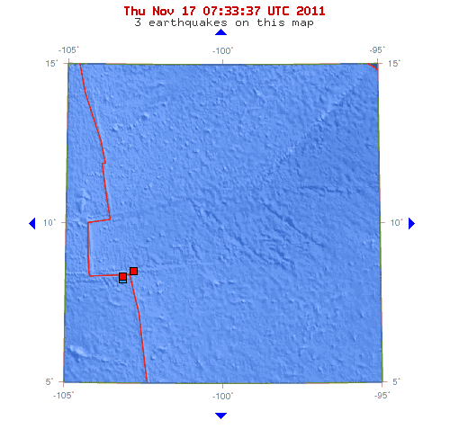
Earth has stomach cramps this morning.
MAP 4.7 2011/11/17 07:50:58 -2.691 122.897 14.8 SULAWESI, INDONESIA
MAP 4.5 2011/11/17 07:45:32 -17.824 -178.692 583.7 FIJI REGION
MAP 4.5 2011/11/17 07:17:01 8.570 -102.858 10.1 NORTHERN EAST PACIFIC RISE
MAP 4.7 2011/11/17 06:58:51 -6.290 129.940 155.9 BANDA SEA
MAP 4.9 2011/11/17 06:52:42 8.409 -103.199 10.0 NORTHERN EAST PACIFIC RISE
MAP 4.5 2011/11/17 06:25:50 -37.495 -73.264 27.3 BIO-BIO, CHILE
MAP 4.8 2011/11/17 06:11:53 8.328 -103.190 10.0 NORTHERN EAST PACIFIC RISE
I think will have 2 very interesting days!
Magnitude
5.1
Date-Time
Thursday, November 17, 2011 at 09:43:02 UTC
Thursday, November 17, 2011 at 06:43:02 PM at epicenter
Location
35.675°N, 141.649°E
Depth
17.4 km (10.8 miles)
Region
NEAR THE EAST COAST OF HONSHU, JAPAN
Distances
130 km (81 miles) SE (126°) from Mito, Honshu, Japan
169 km (105 miles) SSE (156°) from Iwaki, Honshu, Japan
172 km (107 miles) E (89°) from TOKYO, Japan
Location Uncertainty
horizontal +/- 13.6 km (8.5 miles); depth +/- 6.2 km (3.9 miles)
Parameters
NST=200, Nph=202, Dmin=325.1 km, Rmss=0.59 sec, Gp= 97°,
M-type=body wave magnitude (Mb), Version=7
Source
Magnitude: USGS NEIC (WDCS-D)
Location: USGS NEIC (WDCS-D)
Event ID
usc0006tj7source(earthquake.usgs.gov...
edit on 17-11-2011 by diamondsmith because: Friday
11182011
new topics
-
President BIDEN's FBI Raided Donald Trump's Florida Home for OBAMA-NORTH KOREA Documents.
Political Conspiracies: 3 hours ago -
Maestro Benedetto
Literature: 4 hours ago -
Is AI Better Than the Hollywood Elite?
Movies: 4 hours ago -
Las Vegas UFO Spotting Teen Traumatized by Demon Creature in Backyard
Aliens and UFOs: 8 hours ago -
2024 Pigeon Forge Rod Run - On the Strip (Video made for you)
Automotive Discussion: 9 hours ago -
Gaza Terrorists Attack US Humanitarian Pier During Construction
Middle East Issues: 9 hours ago -
The functionality of boldening and italics is clunky and no post char limit warning?
ATS Freshman's Forum: 10 hours ago -
Meadows, Giuliani Among 11 Indicted in Arizona in Latest 2020 Election Subversion Case
Mainstream News: 11 hours ago -
Massachusetts Drag Queen Leads Young Kids in Free Palestine Chant
Social Issues and Civil Unrest: 11 hours ago
top topics
-
President BIDEN's FBI Raided Donald Trump's Florida Home for OBAMA-NORTH KOREA Documents.
Political Conspiracies: 3 hours ago, 23 flags -
Krystalnacht on today's most elite Universities?
Social Issues and Civil Unrest: 14 hours ago, 9 flags -
University of Texas Instantly Shuts Down Anti Israel Protests
Education and Media: 17 hours ago, 8 flags -
Weinstein's conviction overturned
Mainstream News: 12 hours ago, 8 flags -
Supreme Court Oral Arguments 4.25.2024 - Are PRESIDENTS IMMUNE From Later Being Prosecuted.
Above Politics: 14 hours ago, 8 flags -
Massachusetts Drag Queen Leads Young Kids in Free Palestine Chant
Social Issues and Civil Unrest: 11 hours ago, 7 flags -
Gaza Terrorists Attack US Humanitarian Pier During Construction
Middle East Issues: 9 hours ago, 7 flags -
Las Vegas UFO Spotting Teen Traumatized by Demon Creature in Backyard
Aliens and UFOs: 8 hours ago, 6 flags -
Meadows, Giuliani Among 11 Indicted in Arizona in Latest 2020 Election Subversion Case
Mainstream News: 11 hours ago, 5 flags -
2024 Pigeon Forge Rod Run - On the Strip (Video made for you)
Automotive Discussion: 9 hours ago, 4 flags
active topics
-
Hate makes for strange bedfellows
US Political Madness • 47 • : 19Bones79 -
-@TH3WH17ERABB17- -Q- ---TIME TO SHOW THE WORLD--- -Part- --44--
Dissecting Disinformation • 689 • : daskakik -
University of Texas Instantly Shuts Down Anti Israel Protests
Education and Media • 265 • : Astrocometus -
Gaza Terrorists Attack US Humanitarian Pier During Construction
Middle East Issues • 27 • : ToneD -
Reason of the Existence
The Gray Area • 21 • : BingoMcGoof -
President BIDEN's FBI Raided Donald Trump's Florida Home for OBAMA-NORTH KOREA Documents.
Political Conspiracies • 10 • : nugget1 -
Supreme Court Oral Arguments 4.25.2024 - Are PRESIDENTS IMMUNE From Later Being Prosecuted.
Above Politics • 85 • : Sookiechacha -
Chris Christie Wishes Death Upon Trump and Ramaswamy
Politicians & People • 24 • : nugget1 -
New whistleblower Jason Sands speaks on Twitter Spaces last night.
Aliens and UFOs • 63 • : pianopraze -
SETI chief says US has no evidence for alien technology. 'And we never have'
Aliens and UFOs • 74 • : Justoneman