It looks like you're using an Ad Blocker.
Please white-list or disable AboveTopSecret.com in your ad-blocking tool.
Thank you.
Some features of ATS will be disabled while you continue to use an ad-blocker.

Quake Watch 2011
page: 376share:
Does it seem to anyone else like USGS is playing catch-up? I check their site fairly often; either I've missed a bunch of quakes, or they are adding
them days later....maybe some folks were on vacation.
Take Utah, for instance. 43 quakes in the past week? Looking at the historical seismicity map, I suppose it isn't unusual--just hadn't noticed them.
And a few tiny ones in central Oregon. I guess I just missed them *shrugs*
Take Utah, for instance. 43 quakes in the past week? Looking at the historical seismicity map, I suppose it isn't unusual--just hadn't noticed them.
And a few tiny ones in central Oregon. I guess I just missed them *shrugs*
edit on 11/17/2011 by Olivine because: (no reason given)
So PM, I was reading around and came across this passage from an article on quake statistics:
wordinfo.info...:1/il:E
That in reference to a previous conversation we were having about the effects of barometric pressure on faults under the ocean.
So if it doesn't reach under the soil, then how could it reach the ocean floor and beyond in depth?
Anyway, no need beating a dead horse. On another note: statistically, aren't we coming up due for another 7+ here soon? And when's the next 8+ due?
I won't expect another 9+ in my lifetime.
There is no such thing as "earthquake weather".
Statistically, there is an equal distribution of earthquakes in cold weather, hot weather, rainy weather, etc.
Furthermore, there is no physical way that the weather could affect the forces several miles beneath the surface of the earth.
The changes in barometric pressure in the atmosphere are very small compared to the forces in the crust, and the effect of the barometric pressure does not reach beneath the soil.
wordinfo.info...:1/il:E
That in reference to a previous conversation we were having about the effects of barometric pressure on faults under the ocean.
So if it doesn't reach under the soil, then how could it reach the ocean floor and beyond in depth?
Anyway, no need beating a dead horse. On another note: statistically, aren't we coming up due for another 7+ here soon? And when's the next 8+ due?
I won't expect another 9+ in my lifetime.
Don't mean to keep on this but Puterman can you translate this for me please should we be paying more attention to the VI region? Thx in advance to
you or anyone else that can help ease my nerves on this area.
The last huge earthquake to hit VI was a 7.5 in 1867 actually 144 yrs ago tomorrow.
Source...
Numerous earthquake swarms have occurred near the intersection and just to the west. Linear trends of earthquake near the intersection strike southwest or south and have previously been identified as faults cutting the overriding Virgin Islands Platform...
Westerly spreading rupture would encounter a relatively simple plate interface and therefore could propagate without stopping until it reaches the structures of the Bahama Bank in the subduction zone near 67°W, some 260 km to the west. If this were to occur, the resulting earthquake would be in the range Mw 8.0–8.4
The last huge earthquake to hit VI was a 7.5 in 1867 actually 144 yrs ago tomorrow.
Source...
Originally posted by muzzy
reply to post by JustMike
Thanks, I just tried that and it works.
I'll see what I can draw up, its getting more and more interesting with the Swarms on either side of Central America right now.
Mexico?
Glad to be of service.
About Mexico... Yes, I'd say that's no less likely than some other places that have been mentioned. It's been a good while since their last really bad one. Not that I would wish it on them -- or any other country. I wouldn't wish a big quake on my worst enemy, to be honest.
A member (apologies, forget who!) said a few posts back that they were concerned about the 2.8 Mw quake of Cali in the CSZ area. Frankly I wouldn't be overly concerned about that one; a quick look at the historical seismicity map on USGS shows how very active this region is. True, that quake is close to the triple junction there but I've seen numerous quakes in that area over the years and they haven't led to anything much.
I'm not downplaying the region's potential by any means; I'm well aware of what a monster the CSZ will be when it finally does let go again like it did on Jan 26, 1700. It will make the San Andreas's worst look relatively tame. I'm just saying that the smaller quakes we see there can't be taken as much of an indication that anything major is impending.
But that's looking at things with the sometimes cold detachment of a rather scientific perspective. I'll also say that scientific or not, gut feelings should never be ignored and if any member has such feelings then I have no problem with them posting on that basis. Intuition always has its part to play.
Best regards and I'm beat so goodnight all,
Mike
EDIT: Right now I'm concerned about Bolivia. Just saying. (Gut feeling. That's all.)
edit on 17/11/11 by JustMike because: Fixed link and mentioned Bolivia
reply to post by Anmarie96
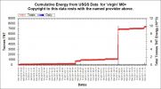
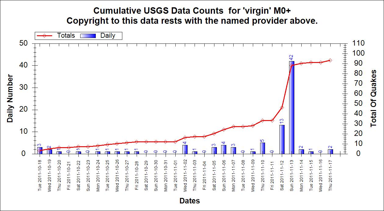
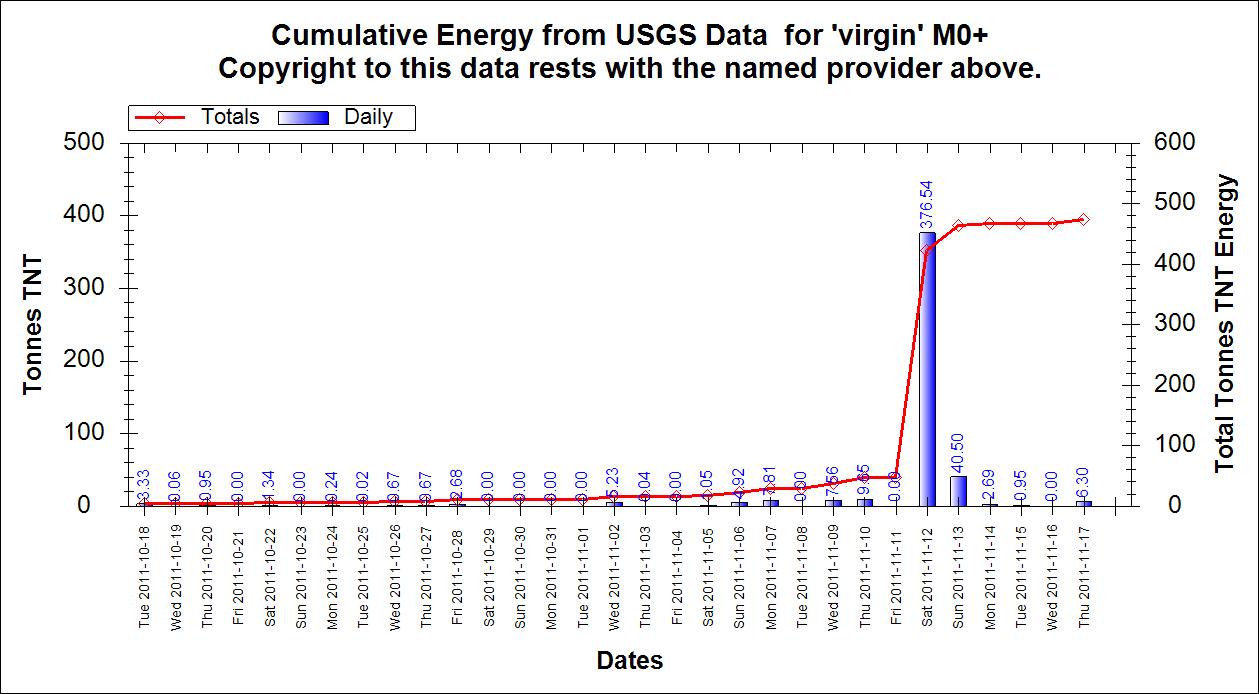
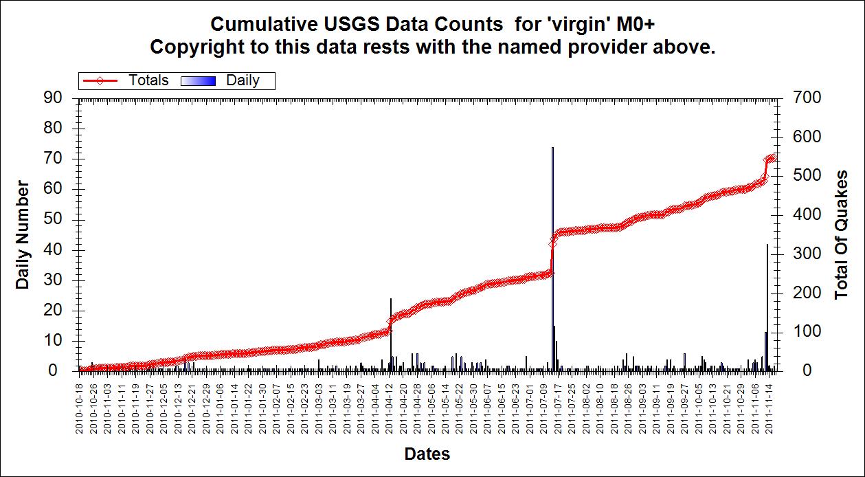
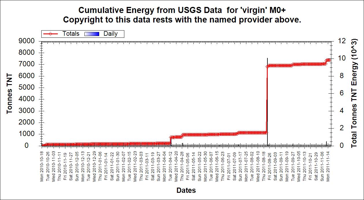
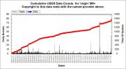
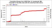
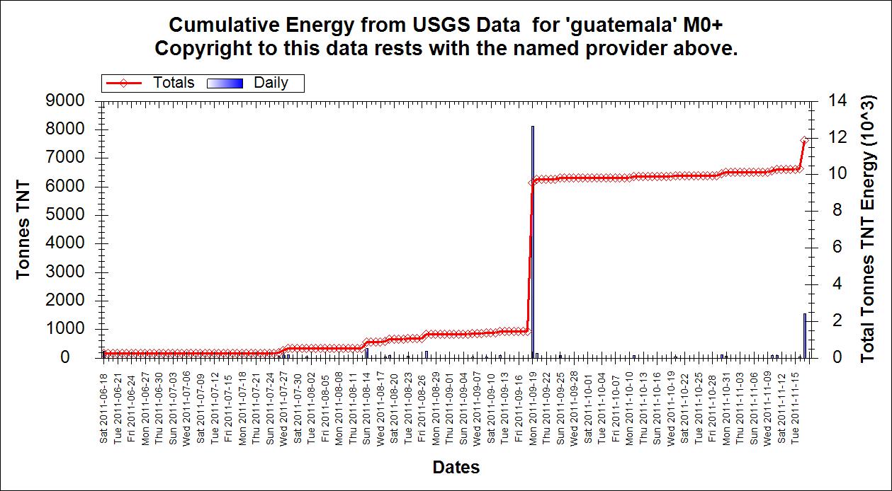
Charting the Virgins
(1) Cumulative total counts for past month

(2) Cumulative energy in tonnes TNT for past month

(3) Cumulative total counts for the past year
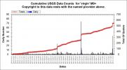
(4) Cumulative energy in tonnes TNT for the past year
Charting the Virgins
(1) Cumulative total counts for past month
(2) Cumulative energy in tonnes TNT for past month
(3) Cumulative total counts for the past year
(4) Cumulative energy in tonnes TNT for the past year
edit on 17/11/2011 by PuterMan because: Darn it can I not get just ONE post without a spelling error? Humph!
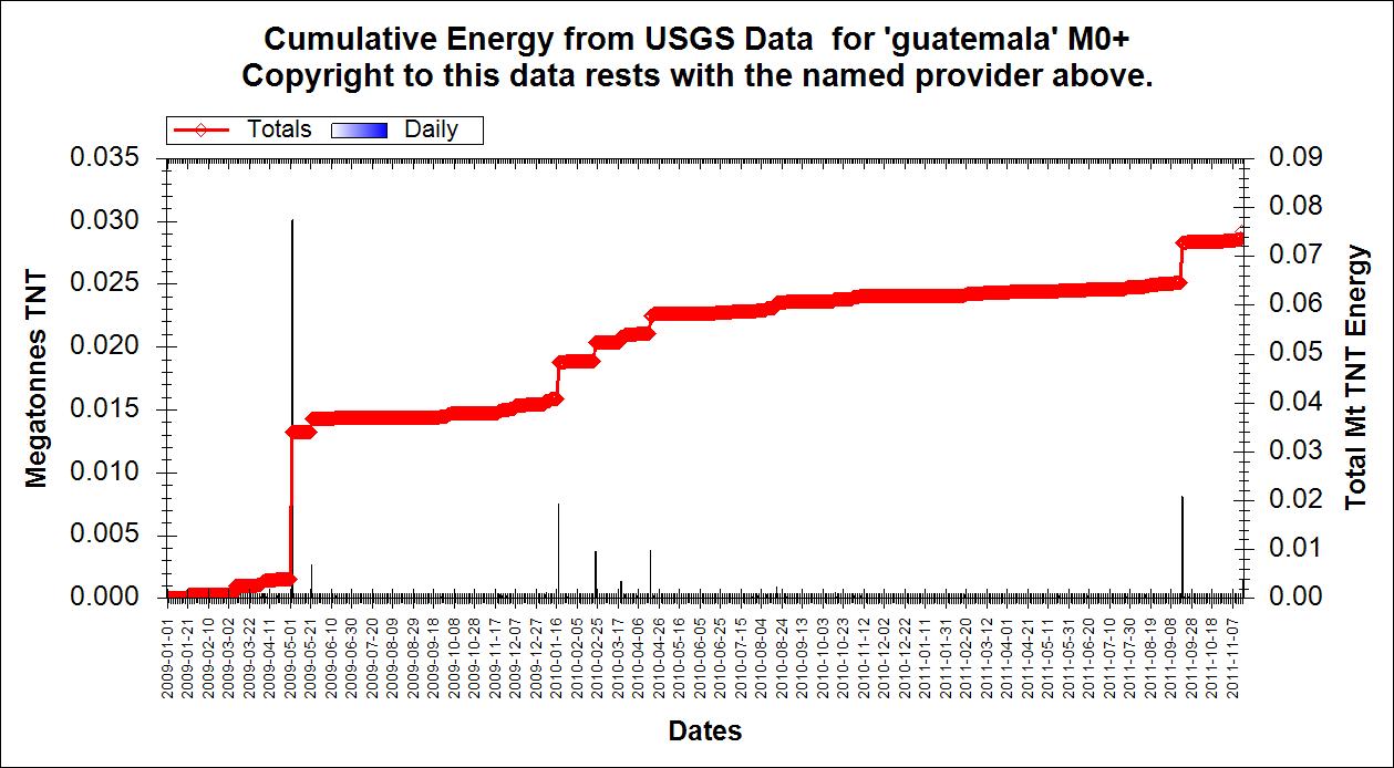
reply to post by Pharyax
Guatemala cumulative total counts from 18 June 2011 to present

Guatemala cumulative energy from 18 June to present. Note that the biggest energy spike is not when the largest number of quakes were. Maybe lots of quakes is good yes?
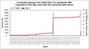
Here is another (counts) for the period since 01 Jan 2009
And energy for the same period
Guatemala cumulative total counts from 18 June 2011 to present
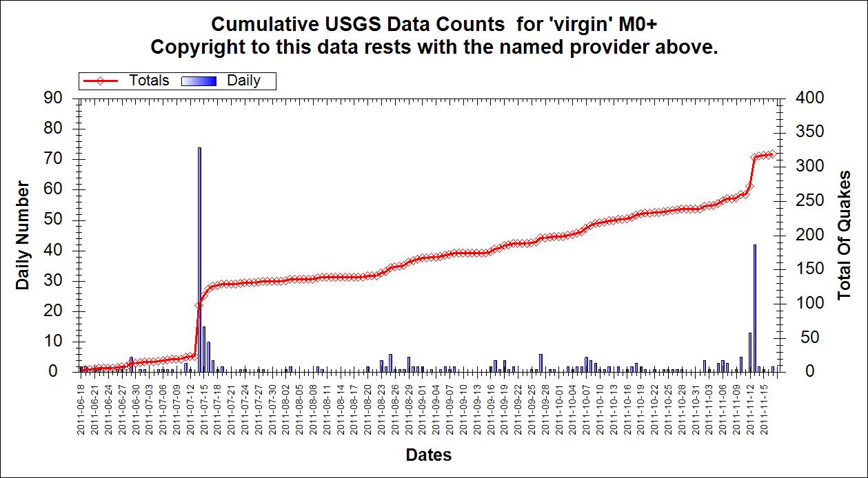
Guatemala cumulative energy from 18 June to present. Note that the biggest energy spike is not when the largest number of quakes were. Maybe lots of quakes is good yes?
Here is another (counts) for the period since 01 Jan 2009
And energy for the same period
edit on 17/11/2011 by PuterMan because: (no reason given)
Hello Puterman,.
will we get a 2011 earthquake graphics and charts of energies and frequencies?
I will be looking forward to your finely calculated work
will we get a 2011 earthquake graphics and charts of energies and frequencies?
I will be looking forward to your finely calculated work
reply to post by TrueAmerican
That article is a direct crib word for word from USGS and we know how much we trust them
earthquake.usgs.gov...
So: How Storms Can Trigger Earthquakes
------------------------------------------------------------
Monastersky, Richard. California Shakes Most Often in September. Science News; Dec. 13, 1997; 152: 373.
www.onereed.com...
------------------------------------------------------------
www.umich.edu...
------------------------------------------------------------
Japan Earthquake: Not Doomsday, Just a Restless Earth
------------------------------------------------------------
adsabs.harvard.edu...
Can't copy any test from that one but it states that barometric pressure played an important part in an earthquake.
------------------------------------------------------------
Source
You want I should stop now? There is more.....
That article is a direct crib word for word from USGS and we know how much we trust them
earthquake.usgs.gov...
So: How Storms Can Trigger Earthquakes
Scientists are increasingly pointing to storms as a trigger for earthquakes and mudslides. That's raising questions about the effects that climate change might have on one of the world's deadliest natural catastrophes, and to what extent, if any, insurers and governments could be adapting to the interplay between atmosphere and earth.
------------------------------------------------------------
Monastersky, Richard. California Shakes Most Often in September. Science News; Dec. 13, 1997; 152: 373.
This is a report on research that suggests that atmospheric pressure causes high frequency of earthquakes in September. The article begins, "Seismologists have discovered a potential link between earthquakes and the weather, a connection that researchers had dismissed for decades.
www.onereed.com...
------------------------------------------------------------
Changes in barometric pressure, even by small amounts, seem to have a significant effect on geyser activity on a year-long scale (Rinehart 1972). Many observers of geyser activity note that the temperature of water in geysers and hot springs increase under reduced pressure conditions, usually during the rainy season.
www.umich.edu...
------------------------------------------------------------
A team led by the late Paul Silver of the Carnegie Institution reported that small earthquakes seem to increase slightly in the autumn, and decrease in the spring. He surmised that barometric pressure may have a slight effect on the ground.
Japan Earthquake: Not Doomsday, Just a Restless Earth
------------------------------------------------------------
adsabs.harvard.edu...
Can't copy any test from that one but it states that barometric pressure played an important part in an earthquake.
------------------------------------------------------------
Until recently, though, the official line from geologists is that such beliefs are false, that there's no relationship between atmospheric and seismic phenomena.
But research published recently in the journal Nature Geosciences says the atmospheric pressure changes associated with some weather systems could help trigger earthquakes, landslides, volcanic eruptions and even the movement of glaciers.
Source
You want I should stop now? There is more.....
Magnitude 5.2
Date-Time
Friday, November 18, 2011 at 02:43:54 UTC
Friday, November 18, 2011 at 02:43:54 PM at epicenter
Time of Earthquake in other Time Zones
Location 37.763°S, 179.418°E
Depth 18.4 km (11.4 miles)
Region OFF EAST COAST OF THE NORTH ISLAND, N.Z.
Distances 158 km (98 miles) NE of Gisborne, New Zealand
281 km (174 miles) E of Rotorua, New Zealand
424 km (263 miles) ESE of Auckland, New Zealand
559 km (347 miles) NE of WELLINGTON, New Zealand
Location Uncertainty horizontal +/- 22.7 km (14.1 miles); depth +/- 8.9 km (5.5 miles)
Parameters NST= 46, Nph= 59, Dmin=100.2 km, Rmss=1.47 sec, Gp= 68°,
M-type=body wave magnitude (Mb), Version=B
Source
Magnitude: USGS NEIC (WDCS-D)
Location: USGS NEIC (WDCS-D)
Event ID usc0006tze
earthquake.usgs.gov...
I'm glad Putermans cumulative Virgin Islands graph for 2011 shows the 14th, 15th, 16th July swarm, at least I know I am on the same page. I only used
Mag 3+, so I've only got 41 events for the 14th.
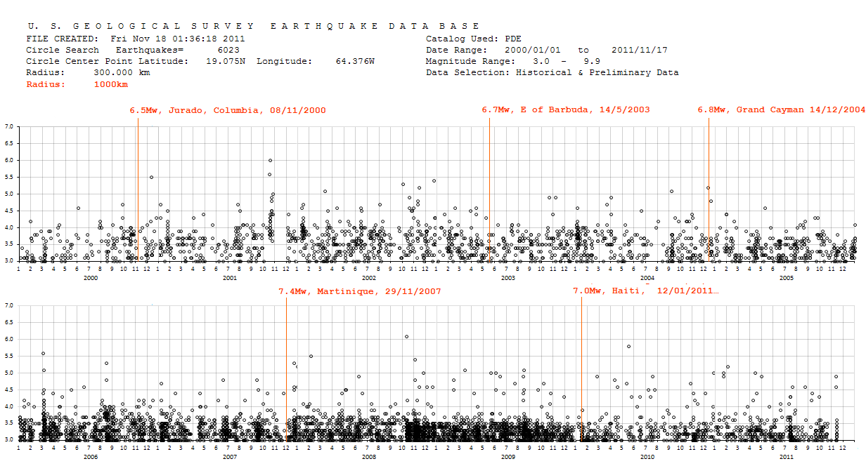
What I have done is go back 12 years and plotted 6023 events on a timeline. (search parameters are on the graph)
You can clearly see the clusters of swarms where the circles either overlap and become a clump, or stack vertically.
I've also marked the significant quakes over Mag 6.5 that occurred during the same period within 1000km (in red)
reply to post by wasobservingquietly
my graph also shows what you recall you saw, and indeed leading up to the Haiti quake of 12/01/2011 the Virgin Islands were rockin, basically all year prior from about early October 2008 to the end of December 2009.
But what may be more significant ...... see the gap with minimal activity in the 12 days leading up to the Haiti quake
this matches with a similar gap late Nov 2007 before the Martinique 7.4mw
And the gap before the 5.6 of March 2nd 2006 north of Anegada Ridge and the 113 aftershocks through to March 8th.
Also interesting is the big gap in November 2001 after the Mag 5.6 and 6.0 on near Anegada Canyon N of the VIs. on October 16 & 17th, no quakes at all for a month.
so it seems one should "look for the gaps",
not "yikes theres a swarm, so there must be a big one coming",
the data shows otherwise.
as is the case in New Zealand, lots of small quakes per day are good, it means the pent up energy is being released (even if only marginally),
no quakes in a normally active area is more cause for concern !
edit on 17-11-2011 by muzzy because: (no reason given)
reply to post by muzzy
Thank you Muzzy that graph was awesome! Thanks for the charted virgins PuterMan also awesome.
This thread and the many posters continue to teach me something new
Looks like another ...
Thank you Muzzy that graph was awesome! Thanks for the charted virgins PuterMan also awesome.
This thread and the many posters continue to teach me something new
Looks like another ...
Magnitude 5.7 Date-Time Friday, November 18, 2011 at 04:34:07 UTC Friday, November 18, 2011 at 04:34:07 PM
Source...edit on 18-11-2011 by LorraineRKO because: To add Source.
A frozen blow!
Magnitude
5.3
Date-Time
Friday, November 18, 2011 at 06:00:54 UTC
Friday, November 18, 2011 at 03:00:54 AM at epicenter
Location
33.711°N, 38.509°W
Depth
9.9 km (6.2 miles)
Region
NORTHERN MID-ATLANTIC RIDGE
Distances
2011 km (1250 miles) W (279°) from Funchal, Madeira Islands, Portugal
2450 km (1522 miles) E (79°) from HAMILTON, Bermuda
Location Uncertainty
horizontal +/- 17.3 km (10.7 miles); depth +/- 2.9 km (1.8 miles)
Parameters
NST=317, Nph=317, Dmin=>999 km, Rmss=0.72 sec, Gp= 68°,
M-type=body wave magnitude (Mb), Version=8
Source
Magnitude: USGS NEIC (WDCS-D)
Location: USGS NEIC (WDCS-D)
Event ID
usc0006usource(earthquake.usgs.gov...
edit on 18-11-2011 by diamondsmith because: Friday
11182011
Another one off East Cape, NZ
this is unusual for NZ, the magnitudes are building at this location.
same spot as the 1995 East Cape 7.0
Reference Number 3612567
Universal Time November 18 2011 at 4:34
NZ Daylight Time Friday, November 18 2011 at 5:34 pm
Latitude, Longitude 37.42°S, 179.99°E
Focal Depth 33 km
Richter magnitude 5.8
Region Kermadec Trench
Location
140 km east of Tikitiki
150 km east of Te Araroa
220 km north-east of Gisborne
470 km east of Auckland
this is unusual for NZ, the magnitudes are building at this location.
same spot as the 1995 East Cape 7.0
The 1995 (February 5) Waitangi Day sequence, offshore East Cape, began with a magnitude 7.0 mainshock at 22:51:02 UTC at a depth of 12km and was followed by 696 aftershocks events 2.84 - 5.99ML within the first 24 hours of the main rupture.
Over the next three weeks a prolific aftershock sequence continued in the outer rise and trench of the Hikurangi margin on the north western face of the Ruatoria undersea debris avalanche of c. 170,000 years ago.
The sequence, to the end of 1995 consisted of ;
2 events 6.2 and 6.6, one at 5.991(6.0)
78 events 5.0 to 5.945
731 events 4.0 to 4.937
2091 events 3.0 to 3.949
115 events 2.0 to 2.95
edit on 18-11-2011 by muzzy because: (no reason given)
reply to post by muzzy
I think Muzz you are right!
Magnitude mb 5.5
Region OFF E. COAST OF N. ISLAND, N.Z.
Date time 2011-11-18 07:51:23.1 UTC
Location 37.79 S ; 179.58 E
Depth 2 km
Distances 302 km E Tauranga (pop 110,338 ; local time 20:51:23.1 2011-11-18)
167 km NE Gisborne (pop 34,274 ; local time 19:51:23.1 2011-11-18)
110 km E Ruatoria (pop 897 ; local time 19:51:23.1 2011-11-18)source(www.emsc-csem.org...
and USGS
Magnitude
6.1
Date-Time
Friday, November 18, 2011 at 07:51:27 UTC
Friday, November 18, 2011 at 07:51:27 PM at epicenter
Location
37.608°S, 179.243°E
Depth
26 km (16.2 miles)
Region
OFF EAST COAST OF THE NORTH ISLAND, N.Z.sourceearthquake.usgs.gov...
edit on 18-11-2011 by diamondsmith because: USGS
Eric just tell me,How in the world did you knew that???
Originally posted by ericblair4891
www.pbs.org...
reply to post by diamondsmith
Eric knows lots of stuff.
But as some might have come in later and missed what that link to PBS was for, I've embedded the PBS video that Eric referred to. (This is from the PBS Network's own channel on Youtube.) I think it's an excellent report and well worth watching, especially as it not only refers to Japan, but also the tsunami potential for the Pacific Northwest from the subuction zone off the coast from BC (Canada) down past WA, OR and CA:
Note that in just the one small beachside community of Seaside, Oregon that's studied (viz around the 4:15 mark in the video), they calculated fatalities of 1700 people out of a population of just 6,400 -- if current "flee to high ground" methods are followed to escape a tsunami. That is, more than 25% of the town's population could be lost. Multiply that by the number of communities along a 600-mile stretch of coast and you get some idea of how devastating a post-mega-quake tusnami could be for the PNW.
The problem is simply the lack of time between a megathrust quake occurring and the arrival of a tsunami along the PNW shoreline. In many places, there may only be minutes to evacuate and especially if a quake hits at night when most people are sleeping, a large number will not have enough time to get to high ground.
This is why the researcher recommends a policy of "vertical evacuation" for people in the areas of greatest risk. If they are able to get to high structures (that still have to be strong enough to withstand the quake and tsunami), the number of casualties would be considerably lower -- around 200 for Seaside versus the "flee to high ground" figure of 1700.
I think you've all seen videos from the Japan tsunami of March 11 that were shot by people who took refuge in higher buildings. I'm sure you have also seen those extraordinary shots from a news helicopter as the tsunami rolled across open, almost flat countryside and engulfed everything in its path. Many people in such regions had no chance to get to high ground because there wasn't any close enough.
Unless you're as fast as (world sprint running record holder) Usain Bolt, you probably don't have much chance of outrunning a tsunami across open, almost level ground. And that's assuming you have a clear path and don't have to find your way along pathways and streets that are littered with downed power lines and debris from damaged buildings, at the same time that everyone else is trying to do the same thing.
So, the policy of vertical evacuation makes sense.
You would think that any government that cares about its people would be willing to invest the money to build some escape towers and retrofit older buildings in the regions at risk -- and in fact would waste no time in getting started on these life-saving measures.
You would think.
edit on 18/11/11 by JustMike because: Fixed YT linky
MAP 6.0 2011/11/18 07:51:27 -37.558 179.311 26.8 OFF EAST COAST OF THE NORTH ISLAND, N.Z.
MAP 5.7 2011/11/18 04:34:07 -37.586 179.292 20.1 OFF EAST COAST OF THE NORTH ISLAND, N.Z.
MAP 5.2 2011/11/18 02:43:54 -37.763 179.418 18.4 OFF EAST COAST OF THE NORTH ISLAND, N.Z.
earthquake.usgs.gov...
So the 5.2 was a foreshock to the 5.7, which was a foreshock to the 6.0, which is a foreshock to the?
Umm, what's shaking, NZ? Stay alert muzzy, and other ATS NZ'ers. These kinds of buildup sequences, although unusual, do happen. Let's hope it stops there. A big quake there could cause a tsunami.
I dug up the plot to one of the closest stations to this activity, NZ.URZ:
www.geonet.org.nz...
Muzzy, do you know what network station MXZ is on? (Edit: It is on the same NZ network, but does not show up in GEE at all. And none of NZ network will load in GEE either, no matter what channels are chosen.) It is listed as closest in USGS phase data, before URZ.
neic.usgs.gov...
And OH, muzzy- IU.SNZO is approx 87.5 microns off center. They need to fix that thing instead of spending money on the New World Order.
Also, I pulled the 6.1 waveform in GEE for IU.SNZO, and for amplitude reference- it registered a mere 90 microns/sec. I would have expected more, but it is also some 550+ km away from the epicenter.
edit on Fri Nov 18th 2011 by TrueAmerican because: (no reason given)
reply to post by JustMike
Yes,you are right, but his post was few minutes before NZ 6.0,somehow he knew,ask him!
new topics
-
Ditching physical money
History: 2 hours ago -
One Flame Throwing Robot Dog for Christmas Please!
Weaponry: 3 hours ago -
Don't take advantage of people just because it seems easy it will backfire
Rant: 3 hours ago -
VirginOfGrand says hello
Introductions: 4 hours ago -
Should Biden Replace Harris With AOC On the 2024 Democrat Ticket?
2024 Elections: 4 hours ago -
University student disciplined after saying veganism is wrong and gender fluidity is stupid
Education and Media: 7 hours ago -
Geddy Lee in Conversation with Alex Lifeson - My Effin’ Life
People: 8 hours ago -
God lived as a Devil Dog.
Short Stories: 8 hours ago -
Police clash with St George’s Day protesters at central London rally
Social Issues and Civil Unrest: 10 hours ago -
TLDR post about ATS and why I love it and hope we all stay together somewhere
General Chit Chat: 11 hours ago
top topics
-
Hate makes for strange bedfellows
US Political Madness: 13 hours ago, 20 flags -
Who guards the guards
US Political Madness: 15 hours ago, 13 flags -
University student disciplined after saying veganism is wrong and gender fluidity is stupid
Education and Media: 7 hours ago, 12 flags -
Police clash with St George’s Day protesters at central London rally
Social Issues and Civil Unrest: 10 hours ago, 9 flags -
TLDR post about ATS and why I love it and hope we all stay together somewhere
General Chit Chat: 11 hours ago, 7 flags -
Should Biden Replace Harris With AOC On the 2024 Democrat Ticket?
2024 Elections: 4 hours ago, 5 flags -
Has Tesla manipulated data logs to cover up auto pilot crash?
Automotive Discussion: 17 hours ago, 3 flags -
One Flame Throwing Robot Dog for Christmas Please!
Weaponry: 3 hours ago, 3 flags -
Don't take advantage of people just because it seems easy it will backfire
Rant: 3 hours ago, 3 flags -
Ditching physical money
History: 2 hours ago, 3 flags
active topics
-
Ditching physical money
History • 12 • : CataclysmicRockets -
Joe Biden Just Lost A Primary Election To A Man Nobody Heard Of Until A Minute Ago
2024 Elections • 18 • : WeMustCare -
Remember These Attacks When President Trump 2.0 Retribution-Justice Commences.
2024 Elections • 48 • : fringeofthefringe -
Breaking Baltimore, ship brings down bridge, mass casualties
Other Current Events • 470 • : IndieA -
Should Biden Replace Harris With AOC On the 2024 Democrat Ticket?
2024 Elections • 38 • : Lumenari -
One Flame Throwing Robot Dog for Christmas Please!
Weaponry • 5 • : nugget1 -
Hate makes for strange bedfellows
US Political Madness • 37 • : YourFaceAgain -
Candidate TRUMP Now Has Crazy Judge JUAN MERCHAN After Him - The Stormy Daniels Hush-Money Case.
Political Conspiracies • 742 • : Annee -
1980s Arcade
General Chit Chat • 24 • : 5thHead -
Don't take advantage of people just because it seems easy it will backfire
Rant • 4 • : VirginOfGrand