It looks like you're using an Ad Blocker.
Please white-list or disable AboveTopSecret.com in your ad-blocking tool.
Thank you.
Some features of ATS will be disabled while you continue to use an ad-blocker.

Quake Watch 2011
page: 309share:
Earthquake in Adelaide JUST THEN! SerialLurker www.abovetopsecret.com/forum/thread765719/pg1
seems a 3.3 magnitude as Geoscience Australia reports.
Near Coast of South Australia, Australia.
Magnitude: 3.3 (ML)
Depth: 17 km
Location
Coordinates: -35,034, 138,671
www.ga.gov.au/earthquakes/getQuakeDetails.do?quakeId=3117389
earthquake.usgs.gov/earthquakes/recenteqsww/Quakes/usc0006b4x.php
seems a 3.3 magnitude as Geoscience Australia reports.
Near Coast of South Australia, Australia.
Magnitude: 3.3 (ML)
Depth: 17 km
Location
Coordinates: -35,034, 138,671
www.ga.gov.au/earthquakes/getQuakeDetails.do?quakeId=3117389
earthquake.usgs.gov/earthquakes/recenteqsww/Quakes/usc0006b4x.php
* This event has been reviewed by a seismologist.
Magnitude 3.3
Date-Time
* Tuesday, October 18, 2011 at 15:52:25 UTC
* Wednesday, October 19, 2011 at 01:22:25 AM at epicenter
Location 35.034°S, 138.671°E
Depth 17 km (10.6 miles)
Region NEAR THE COAST OF SOUTH AUSTRALIA
Distances
* 13 km (8 miles) SSE (150°) from Adelaide, Australia
* 432 km (268 miles) SW (217°) from Broken Hill, Australia
* 951 km (591 miles) W (269°) from CANBERRA, Australia
Location Uncertainty horizontal +/- 46.4 km (28.8 miles); depth +/- 14 km (8.7 miles)
Parameters Nph= 0, Dmin=0 km, Rmss=1.46 sec, Gp= 0,
M-type=local magnitude (ML), Version=3
Source
* Magnitude: Geoscience Australia, Canberra, ACT, Australia
Location: Geoscience Australia, Canberra, ACT, Australia
Event ID usc0006b4x
edit on 18-10-2011 by jjjtir because: (no reason given)
Here's another one in Arkansas:
Source: USGS
Be Well.
Magnitude
2.3
Date-Time
Tuesday, October 18, 2011 at 17:02:20 UTC
Tuesday, October 18, 2011 at 12:02:20 PM at epicenter
Location
35.359°N, 92.272°W
Depth
5.9 km (3.7 miles)
Region
ARKANSAS
Distances
5 km (3 miles) WSW (243°) from Quitman, AR
7 km (4 miles) NE (56°) from Guy, AR
13 km (8 miles) E (94°) from Damascus, AR
34 km (21 miles) NNE (29°) from Conway, AR
69 km (43 miles) N (4°) from Little Rock, AR
406 km (252 miles) SSW (207°) from St. Louis, MO
Location Uncertainty
horizontal +/- 1.9 km (1.2 miles); depth +/- 1.9 km (1.2 miles)
Parameters
NST= 9, Nph= 13, Dmin=8 km, Rmss=0.11 sec, Gp= 83°,
M-type=duration magnitude (Md), Version=A
Source
Cooperative New Madrid Seismic Network
Event ID
nm101811b
Source: USGS
Be Well.
reply to post by eeks4
Must have had a short life then
I have 136 quakes 3+ in 7 days from USGS and that is WAY light on normal which is upwards of 300+ normally. I just picked a random week in June (quietish) and got 174 and a random one in Feb was 134 and Feb was quiet. Middle of July - 233.
It is quiet at present. Often is in October.
reply to post by diamondsmith
Narr need to take hit to heart geeza I wuz just pointin hout dat some peeps as da beef coz dey only as dial up poota stuff. da link wuz yorkie.
Narr need to take hit to heart geeza I wuz just pointin hout dat some peeps as da beef coz dey only as dial up poota stuff. da link wuz yorkie.
I was working on this last night until 2 AM, & quit when I got bleary eyed. I wasn't going to bother, but since a couple of people mentioned it
today....This is my third try. If I lose it again you will see a big blank edited page!!!
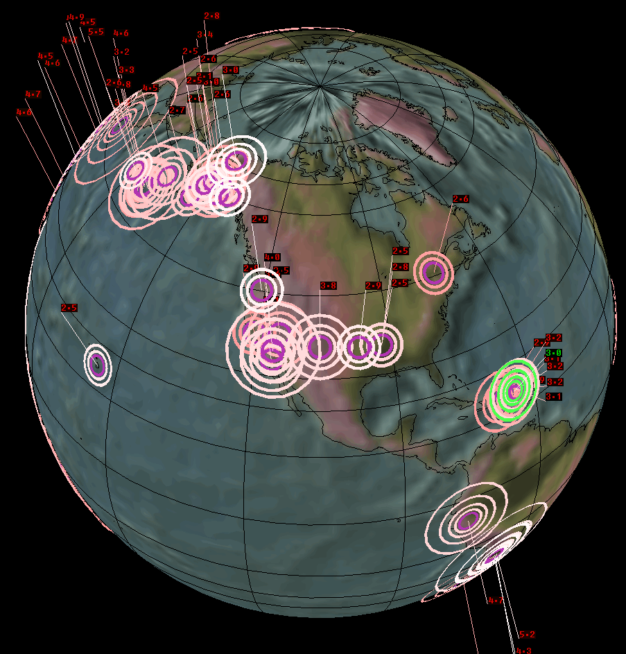
EQ's in the US on the 35th latitude in the last week: CA, NM, OK, AR & TN.
EQ's in the US in the 30's latitudes in the last week: CA, NM, OK, AR, TN, CO, TX, UT, AZ, NV, MO, IN, NC, SC, IN, AL, WV & VA.
EQ's in the world in the last week in the 30's latitudes: US, Mexico, Greece, Turkey, Turkey-Syria-Iraq border region, Italy, Aegean Sea, Cyprus, Spain, Mediterranian Sea, Ionian Sea, Dead Sea, Azores, Kyrgyzstan,Tajikistan, Iran, Kashmir, Strait of Gibralter, Kermadec Islands, Mid Indian Ridge, Chile & Japan.
If you go back 8 days there's also Afghanistan.
The earth is cracking like an egg!!!
www.emsc-csem.org...
earthquake.usgs.gov...
edit on 18-10-2011 by wasobservingquietly because: Posted the links as an
edit so I didn't lose my post for a third time!!!
reply to post by PuterMan
PM and eeks4...I know my post here will be like Nursery School to the University level links and research done here...but it there IS a lot occurring along the 37th parallel on the USGS map.
Starting in the east, Mineral, VA, going west thru TN, then Arkansas (the swarm around Quitman); OKlahoma, then the unique 'oddball' New Mexico quake; Nevada (several) and California (Long Valley) also several small ones...all along 37 latitude.
Just a weird coincidence or ???
(Going back to just being a reader.)
Yo people need to get a grip and a better perspective of the number and magnitudes of events in the eastern side of the Rockies, especially the New
Madrid over the last 6 months
Have a play with this map from CERI
www.ceri.memphis.edu...
click and unclick the Magnitude Boxes on the Control Panel
ie unclick all the boxes except the 4 and wow ........ 6 quakes
click off all but the 3's and holy smokes ............... 33 quakes Mag 3
lets face it over a period of 6 months thats not a lot
Have a play with this map from CERI
www.ceri.memphis.edu...
click and unclick the Magnitude Boxes on the Control Panel
ie unclick all the boxes except the 4 and wow ........ 6 quakes
[color=FFFC17]Mag Date Time(UTC) Depth
4.0 2011/09/18 19:19:14 05 km
4.0 2011/09/13 05:24:39 05 km
4.4 2011/09/11 12:27:45 10 km
4.5 2011/08/25 05:07:50 05 km
4.2 2011/08/24 00:04:36 07 km
4.6 2011/08/22 23:30:20 05 km
click off all but the 3's and holy smokes ............... 33 quakes Mag 3
[color=E6A9EC] Mag Date Time(UTC) Depth
3.0 2011/10/12 16:40:00 04 km
3.1 2011/10/10 13:26:28 01 km
3.3 2011/10/05 09:38:30 04 km
3.6 2011/09/22 23:32:09 11 km
3.8 2011/09/16 14:51:51 05 km
3.0 2011/09/13 22:59:23 05 km
3.4 2011/09/13 01:37:19 06 km
3.3 2011/09/12 15:35:28 03 km
3.4 2011/09/12 14:18:34 07 km
3.4 2011/09/01 09:09:38 03 km
3.1 2011/08/31 09:35:12 05 km
3.2 2011/08/25 03:44:41 07 km
3.4 2011/08/24 17:14:32 05 km
3.0 2011/08/24 07:15:57 05 km
3.4 2011/08/24 04:45:26 04 km
3.9 2011/08/23 14:11:13 05 km
3.2 2011/08/23 09:37:57 05 km
3.8 2011/08/23 07:17:58 04 km
3.2 2011/08/23 07:01:35 05 km
3.5 2011/08/23 06:56:59 05 km
3.0 2011/08/23 02:48:52 05 km
3.0 2011/08/18 16:50:51 09 km
3.3 2011/08/09 19:45:17 05 km
3.0 2011/07/17 06:57:59 05 km
3.9 2011/06/07 08:10:36 20 km
3.0 2011/06/05 15:35:20 05 km
3.9 2011/05/11 19:06:14 05 km
3.9 2011/05/09 23:28:53 04 km
3.1 2011/05/09 14:46:43 18 km
3.1 2011/05/07 13:08:29 06 km
3.2 2011/05/02 19:07:15 05 km
3.2 2011/04/24 06:18:57 05 km
3.1 2011/04/23 12:20:31 05 km
lets face it over a period of 6 months thats not a lot
reply to post by muzzy
Darn it you beat me too it!
I was just coming in to say taking Lat 30/39.99 x Lon -125/-75 there were 1860 1+ in the last month.
Chop that to Lon -103/-75 to exclude California and there were just 74. Only 3 of those were mag 3+ (3. 3.3, 3.6) and the rest were all 2+ or 1+
As you say Mr Muzzy Sir. Norra lot really!
I could have sworn someone said and 35 South - the Adelaide quake.
Cant' see it now.
Guess what they are doing there? Go on have a guess.
www.pir.sa.gov.au...
and
www.pir.sa.gov.au...
I don't think these are up to date maps because they talk about the 1986 acreage.
You can bet your bottom $AUS they are fracking the hell out of these areas now.
Cant' see it now.
Guess what they are doing there? Go on have a guess.
www.pir.sa.gov.au...
and
www.pir.sa.gov.au...
I don't think these are up to date maps because they talk about the 1986 acreage.
You can bet your bottom $AUS they are fracking the hell out of these areas now.
Drilled its first gas and oil discovery well in July 2007
edit on 18/10/2011 by PuterMan because: (no reason given)
reply to post by PuterMan
Yes, they're starting to frac the hell out of Australia. People were attending protests last weekend. They're fracking in areas of our main food bowls, our agricultural lands in Queensland and our Murray Darling Basin on the NSW/VIC border. There are families who are suddenly becoming very sick. Yet our biggest mining boom is apparently about to begin and the recruiting adverts are everywhere. So I'll be watching for any and all tremors.
Yes, they're starting to frac the hell out of Australia. People were attending protests last weekend. They're fracking in areas of our main food bowls, our agricultural lands in Queensland and our Murray Darling Basin on the NSW/VIC border. There are families who are suddenly becoming very sick. Yet our biggest mining boom is apparently about to begin and the recruiting adverts are everywhere. So I'll be watching for any and all tremors.
I had the 35th south in Australia on my post, but when I edited it to add the links, they ate Australia!!!
I hope I get computer lessons for Christmas!
Wasn't so much referring to the amount of eq's overall, but how many states have had them in a short time span. Especially in states that can go quite a while without having any.
Kind of like old popcorn. You don't get a lot of pops at one time. But use fresh ones, & they are popping up all over. Not unexpected in the New Madrid. What was it in that last AR swarm 2,000?
What seems different is so many in different states in a small time frame. And not just in the 30's latitude. But it is interesting that there are so many in a narrow band across the US in that short time span.
An art instructor gave me an 'F' on a drawing one time because I used a ruler. He said, "There are no perfectly straight lines in nature!" I didn't even think about it until after I had finished that class, but I was drawing something man made, not something from nature! Anyway... I digress...
Unless there is an unknown fault line across the whole US that is in the 30's latitude, it just seems more than coincidence that there would be so many in different states, in a line, west to east, in a week's time. Kind of like when CO & VA were playing tag. Not the norm. It makes you go hmmmm.....
Originally posted by PuterMan
reply to post by muzzy
Darn it you beat me too it!
Only because I'm 12 hrs ahead of you
and the fact its raining, so I'm at home
otherwise I wouldn't have posted anything
I wonder if this persieved 35th parallel line of USA quakes has anything to do with the angle of the earth at this time of year in relation to the
Sun?.
Very quiet in NZ at the moment, well on land anyway.
Very quiet in NZ at the moment, well on land anyway.
reply to post by zenius
I was impressed when we visited my husband's family in Australia. We felt so much better when we were there, & needed much less sleep. At first I attributed it to the adrenalin rush of being on vacation. But as time went on & I did some investigating, I found they used a lot less additives & chemicals in their food than we did. We felt great until the first meal on the plane on the way back home. (An American airline!) Then we got quite ill!
I don't know if the food is still that much healthier than ours, but I hope so! I sure hope they can do away with the drilling! Didn't I read that Australia doesn't even have a nuclear reactor? Something so pristine needs to be especially protected!
reply to post by wasobservingquietly
We have a nuclear medicine facility and there's conflict happening with the indigenous of the Northern Territory because the Federal Government have earmarked their land for a waste dump. We are lucky in some areas that we can buy locally grown fresh produce, but we still have flouride in our city water supplies and the usual fertilizers etc on our farming land.
@Puterman, that South Australia quake was very close to Adelaide. I haven't heard of any mining around there. The area is full of well established and popular wineries. If they were going to fracc there, it would surely cause an uproar. There are faults through that area I believe.
edit on
18-10-2011 by zenius because: (no reason given)
Magnitude 5.5 - SOUTHERN IRAN
This event has been reviewed by a seismologist.
Magnitude 5.5
Date-Time
Wednesday, October 19, 2011 at 02:52:44 UTC
Wednesday, October 19, 2011 at 06:22:44 AM at epicenter
Time of Earthquake in other Time Zones
Location 28.146°N, 54.297°E
Depth 40.3 km (25.0 miles)
Region SOUTHERN IRAN
Distances 51 km (31 miles) N of Lar, Iran
82 km (50 miles) ESE of Jahrom, Iran
185 km (114 miles) NNW of Bandar-e Lengeh, Iran
877 km (544 miles) SSE of TEHRAN, Iran
Location Uncertainty horizontal +/- 15.2 km (9.4 miles); depth +/- 10 km (6.2 miles)
Parameters NST=149, Nph=150, Dmin=403 km, Rmss=0.82 sec, Gp= 47°,
M-type=body wave magnitude (Mb), Version=6
Source
Magnitude: USGS NEIC (WDCS-D)
Location: USGS NEIC (WDCS-D)
Event ID usb00069zp
A couple quick comments:
Been watching what appear to be small aftershocks continuing in the Iran area on a station in the UAE (across the Strait of Hormuz), in GEE. But with only one station I can find, it's hard to know for sure. The signatures look like quakes, in the 1.5 to 3 range (small and off the USGS 4.5+ world list.)
And PuterMan, wasn't this 4.8 somewhere near your "spot" of an expected quake in near future? Or is that further north from there- can't remember where it was you said...
earthquake.usgs.gov...
These Iranian quakes are the first I've seen where I really hope that they are quakes and not another US foray into a foreign country with drones and
bomber pilots. I am sure by now it would be breaking news had we invaded so I will assume they are genuine quakes and I spend too much time on ATS
UK at it earlier today!
DATE 19/10/2011
ORIGIN TIME 02:32:46.9 UTC
LOCATION 53.206 -0.868
DEPTH 4 km
MAGNITUDE 1.6
LOCALITY TUXFORD,NOTTS
macroseismic report received 19 Oct 2011, location : New Ollerton approx 9km west of the epicentre. It was reported that the individual was woken by a weak trembling. GDF 19 Oct 2011
www.earthquakes.bgs.ac.uk...=summary
Rainbows
Jane
new topics
-
Big Storms
Fragile Earth: 1 hours ago -
Where should Trump hold his next rally
2024 Elections: 3 hours ago -
Shocking Number of Voters are Open to Committing Election Fraud
US Political Madness: 4 hours ago -
Gov Kristi Noem Shot and Killed "Less Than Worthless Dog" and a 'Smelly Goat
2024 Elections: 5 hours ago -
Falkville Robot-Man
Aliens and UFOs: 5 hours ago -
James O’Keefe: I have evidence that exposes the CIA, and it’s on camera.
Whistle Blowers and Leaked Documents: 6 hours ago -
Australian PM says the quiet part out loud - "free speech is a threat to democratic dicourse"...?!
New World Order: 7 hours ago -
Ireland VS Globalists
Social Issues and Civil Unrest: 7 hours ago -
Biden "Happy To Debate Trump"
2024 Elections: 8 hours ago -
RAAF airbase in Roswell, New Mexico is on fire
Aliens and UFOs: 8 hours ago
top topics
-
A Warning to America: 25 Ways the US is Being Destroyed
New World Order: 17 hours ago, 21 flags -
Blast from the past: ATS Review Podcast, 2006: With All Three Amigos
Member PODcasts: 10 hours ago, 13 flags -
James O’Keefe: I have evidence that exposes the CIA, and it’s on camera.
Whistle Blowers and Leaked Documents: 6 hours ago, 13 flags -
Biden "Happy To Debate Trump"
2024 Elections: 8 hours ago, 12 flags -
Australian PM says the quiet part out loud - "free speech is a threat to democratic dicourse"...?!
New World Order: 7 hours ago, 12 flags -
Mike Pinder The Moody Blues R.I.P.
Music: 10 hours ago, 8 flags -
What is the white pill?
Philosophy and Metaphysics: 9 hours ago, 6 flags -
Shocking Number of Voters are Open to Committing Election Fraud
US Political Madness: 4 hours ago, 5 flags -
Ireland VS Globalists
Social Issues and Civil Unrest: 7 hours ago, 5 flags -
RAAF airbase in Roswell, New Mexico is on fire
Aliens and UFOs: 8 hours ago, 5 flags
active topics
-
"We're All Hamas" Heard at Columbia University Protests
Social Issues and Civil Unrest • 293 • : marg6043 -
So this is what Hamas considers 'freedom fighting' ...
War On Terrorism • 267 • : NorthOS -
President BIDEN Vows to Make Americans Pay More Federal Taxes in 2025 - Political Suicide.
2024 Elections • 146 • : Zanti Misfit -
Definitive 9.11 Pentagon EVIDENCE.
9/11 Conspiracies • 427 • : Zanti Misfit -
Big Storms
Fragile Earth • 8 • : charlest2 -
SHORT STORY WRITERS CONTEST -- April 2024 -- TIME -- TIME2024
Short Stories • 24 • : argentus -
Gov Kristi Noem Shot and Killed "Less Than Worthless Dog" and a 'Smelly Goat
2024 Elections • 35 • : nugget1 -
Ireland VS Globalists
Social Issues and Civil Unrest • 7 • : boatguy12 -
I am beholden to my truth, of which I share with you now.
Dreams & Predictions • 24 • : BrotherKinsMan -
Starburst galaxy M82 - Webb Vs Hubble
Space Exploration • 11 • : Arbitrageur