It looks like you're using an Ad Blocker.
Please white-list or disable AboveTopSecret.com in your ad-blocking tool.
Thank you.
Some features of ATS will be disabled while you continue to use an ad-blocker.

Quake Watch 2011
page: 307share:
reply to post by Robin Marks
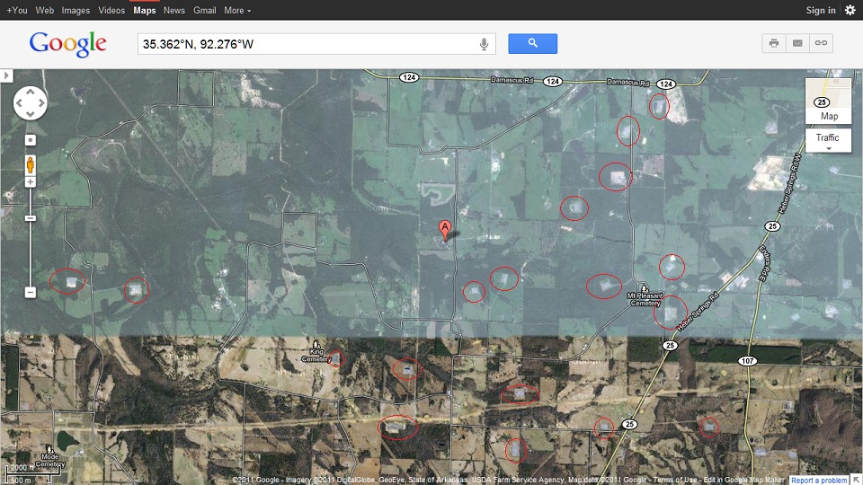
Now, not all the indicated areas of interest are frak pads, many of them are, you can even see the evaporation ponds next to several of the spots I have indicated.
You are right to focus on the small things. It is often those that make the biggest difference in the long run. Just ask anyone who understands navigation, a small change in heading will produce an enormous change in where one ends up.
And then there is the whole butterfly effect in which small changes to the initial conditions of a system produce widely variable effects the longer the system is in operation. All of the small quakes are changing initial conditions all the time. To think that they have no effect on the overall system they are embedded within (the NMSZ) is folly of the highest order.
New Mexico is rocking:
Source: USGS
This one is pretty shallow.
Be Well.
Magnitude
3.8
Date-Time
Monday, October 17, 2011 at 16:38:50 UTC
Monday, October 17, 2011 at 10:38:50 AM at epicenter
Location
35.828°N, 105.951°W
Depth
1.1 km (~0.7 mile) (poorly constrained)
Region
NEW MEXICO
Distances
16 km (9 miles) N of SANTA FE, New Mexico
32 km (19 miles) ESE of Los Alamos, New Mexico
68 km (42 miles) WNW of Las Vegas, New Mexico
72 km (44 miles) SSW of Taos, New Mexico
Location Uncertainty
horizontal +/- 12.1 km (7.5 miles); depth +/- 10.3 km (6.4 miles)
Parameters
NST= 24, Nph= 29, Dmin=108 km, Rmss=0.71 sec, Gp= 61°,
M-type=centroid moment magnitude (Mw), Version=6
Source
Magnitude: USGS NEIC (WDCS-D)
Location: USGS NEIC (WDCS-D)
Event ID
usc0006ap0
Source: USGS
This one is pretty shallow.
Be Well.
edit on 10/17/2011 by Bishop2199 because: (no reason given)
reply to post by Robin Marks
Thanks Robin, I didn't have that seismo link yet. Is that the closest one to Quitman?
There was just an article in our paper last week where the school board is wondering whether to let 'them' do seismic testing on the elementary school property in the next town. They don't know if they would go ahead with drilling or not if they did find something, so why even test? A couple of the members thought it would be great if they did find something, then they could pay for a new roof....etc. I think they said they have two parcels. A three acre one & an eleven acre one. The school is bounded on the front by the highway & on the back by a mountain. How would they even be able to have classes? Assuming it started up in the summer during school break, there's still all the traffic & dust! Not to mention the dangers. What are they thinking doing it that close to a school?
Have any of the school board members even taken a drive to see what a drilling operation looks like? All they can see is dollar signs! A lot of people here think it's great. We know someone who works for a drilling company. They are gone for two weeks, then home for two weeks. They make $5,000 / paycheck. Dollar signs! There has already been an explosion & a death in our state. Plus they don't even know the health hazards yet!
I'm afraid it will take something really bad to shake their blinders off! If an explosion & death, (and earthquakes), don't do it, what will it take???!!!
Years ago they stripped the mountains bare here. We had huge forests of hemlock trees that they used for lumber & tanning. People now, shake their heads & wonder, how could they have done something like that! How could they have been so clueless? It's the same thing all over again, only a different century & another commodity!
reply to post by Bishop2199
Yikes this one is only 19 miles ESE of Los Alamos laboratory that makes me feel uneasy. Hopefully it's the only one..... Really shallow too! Is this normal for this area the others were north in Colorado.
Yikes this one is only 19 miles ESE of Los Alamos laboratory that makes me feel uneasy. Hopefully it's the only one..... Really shallow too! Is this normal for this area the others were north in Colorado.
reply to post by LorraineRKO
According to the USGS, there wasn't any activity in this area between 1990 and 2006. As a result, it is somewhat of an anomaly and, as such, whether the shallow depth is normal for the area is unknown.
New Mexico as a state has had a few good size quakes, just not in this specific location.
Source: USGS
Be Well.
According to the USGS, there wasn't any activity in this area between 1990 and 2006. As a result, it is somewhat of an anomaly and, as such, whether the shallow depth is normal for the area is unknown.
New Mexico as a state has had a few good size quakes, just not in this specific location.
An earthquake, measured at 3.8, on November 28, 1970, awakened thousands at Albuquerque...On January 22, 1966, a magnitude 5.5 earthquake centered near Dulce affected about 39,000 square kilometers of northwestern New Mexico and southwestern Colorado.
Source: USGS
Be Well.
edit on 10/17/2011 by Bishop2199 because: (no reason given)
reply to post by Bishop2199
Thanks for that info I also saw that people reported feeling it in Mesa AZ. I know there is also a history of volcanic earthquakes near Socorro NM.
Please read full article
vulcan.wr.usgs.gov...
Thanks for that info I also saw that people reported feeling it in Mesa AZ. I know there is also a history of volcanic earthquakes near Socorro NM.
. New Mexico has one of only three large mid-crustal active magma bodies (Socorro) in the continent. (The others are Long Valley, California and Yellowstone, Wyoming.) The Socorro area is one of the few areas where there is a dearth of young volcanoes, so perhaps the Rift is working on filling out its volcano landscaping.
Please read full article
vulcan.wr.usgs.gov...
earthquake.usgs.gov...
Southern California had a 3.1 then a 4.0 has followed. Bigger coming? HOPE NOT!!!!!
Magnitude
4.0
Date-Time
Monday, October 17, 2011 at 20:05:57 UTC
Monday, October 17, 2011 at 01:05:57 PM at epicenter
Time of Earthquake in other Time Zones
Location
34.697°N, 116.294°W
Depth
1.8 km (1.1 miles)
Region
SOUTHERN CALIFORNIA
Distances
13 km (8 miles) WSW (257°) from Ludlow, CA
40 km (25 miles) WNW (288°) from Bagdad, CA
53 km (33 miles) NNW (340°) from Twentynine Palms Base, CA
65 km (41 miles) NNW (342°) from Twentynine Palms, CA
193 km (120 miles) ENE (68°) from Los Angeles Civic Center, CA
Location Uncertainty
horizontal +/- 0.2 km (0.1 miles); depth +/- 0.5 km (0.3 miles)
Parameters
Nph= 62, Dmin=13 km, Rmss=0.22 sec, Gp= 36°,
M-type=local magnitude (ML), Version=1
Source
California Integrated Seismic Net:
USGS Caltech CGS UCB UCSD UNR
Event ID
ci15064556
aftershock
earthquake.usgs.gov...
Magnitude
2.0
Date-Time
Monday, October 17, 2011 at 20:14:44 UTC
Monday, October 17, 2011 at 01:14:44 PM at epicenter
Time of Earthquake in other Time Zones
Location
34.697°N, 116.289°W
Depth
3.2 km (2.0 miles)
Region
SOUTHERN CALIFORNIA
Distances
12 km (8 miles) WSW (257°) from Ludlow, CA
40 km (25 miles) WNW (289°) from Bagdad, CA
53 km (33 miles) NNW (340°) from Twentynine Palms Base, CA
65 km (40 miles) N (10°) from Yucca Valley, CA
65 km (40 miles) NNW (342°) from Twentynine Palms, CA
192 km (120 miles) SSW (210°) from Las Vegas, NV
Location Uncertainty
horizontal +/- 0.3 km (0.2 miles); depth +/- 0.6 km (0.4 miles)
Parameters
Nph= 29, Dmin=13 km, Rmss=0.2 sec, Gp= 54°,
M-type=local magnitude (ML), Version=0
Source
California Integrated Seismic Net:
USGS Caltech CGS UCB UCSD UNR
Event ID
ci15064564
earthquake.usgs.gov...
Hello people,
just a general query: I'm having trouble getting GEE to load the real-time map seismo station locations today. Is anyone else having the same problem?
EDIT (about an hour later, I guess): Okay, finally got GEE to load but it was very slow to get there and is still very glitchy. Not had this problem before in a lonnnng while so if others are having issues I'd like to know. Otherwise I might have to unistall and reinstall.
Thanks,
Mike
edit on 17/10/11 by JustMike because: I added an edit thing.
reply to post by MamaJ
Both the CA quake and the NM quake are at the same depth?
It also seems like a NM/CO quake precede larger quakes elsewhere in the US.
Sorry, just thinking out loud. I'm also still too new to ATS I have no idea how to link or paste correctly yet. The regulars on this thread are awesome keep up the great work and info!
reply to post by LorraineRKO
Hi Lorraine,
I haven't been following CO and NM quakes closely enough lately to know if they indicate larger quakes elsewhere, but hopefuly someone will have some data or observations to add. In any case, nothing wrong with thinking out loud.
Regarding how to post and what coding to use, have a look at the Guide to BBCode on ATS thread. Lots of useful tips there!
About copying and pasting material: if you want to quote something from another post on ATS, use the "quote" coding tags, but if you want to post text that is from an external source, then use the "ex" tags:
[ex]The text pasted from the external source goes here.[/ex]
This gives you:
By using the "ex" tags, it's immediately clear to moderators and others that you are quoting from an external source. Besides that useful benefit, it's also required: we need to use the right tags to comply with the ATS rules on posting intellectual property. (Due to copyright laws etc.)
We'll be happy to help you with anything you need to know about all this, so feel free to ask.
EDIT to add: In fact, the ATS Freshman's Forum is excellent as a general resource. Just about everything is covered there.
Best regards,
Mike
Hi Lorraine,
I haven't been following CO and NM quakes closely enough lately to know if they indicate larger quakes elsewhere, but hopefuly someone will have some data or observations to add. In any case, nothing wrong with thinking out loud.
Regarding how to post and what coding to use, have a look at the Guide to BBCode on ATS thread. Lots of useful tips there!
About copying and pasting material: if you want to quote something from another post on ATS, use the "quote" coding tags, but if you want to post text that is from an external source, then use the "ex" tags:
[ex]The text pasted from the external source goes here.[/ex]
This gives you:
The text pasted from the external source goes here.
By using the "ex" tags, it's immediately clear to moderators and others that you are quoting from an external source. Besides that useful benefit, it's also required: we need to use the right tags to comply with the ATS rules on posting intellectual property. (Due to copyright laws etc.)
We'll be happy to help you with anything you need to know about all this, so feel free to ask.
EDIT to add: In fact, the ATS Freshman's Forum is excellent as a general resource. Just about everything is covered there.
Best regards,
Mike
edit on 17/10/11 by JustMike because: Shpellink erra and an ETA.
There's a glitch on the LA quake cam again! What the heck!!! The drum is not moving, the needle is stuck off the bottom of the drum & options for
video links are blocking the screen! You can just see a little bit of the drum on the right hand side!
Time to put in a call for someone....how do I say this.....more knowledgeable !!! Two times in less than 24 hours?
Time to put in a call for someone....how do I say this.....more knowledgeable !!! Two times in less than 24 hours?
reply to post by JustMike
Thank you Mike! Just wanted to post a link to this article to make sure I followed your instructions correctly.
Maybe my dad wasn't kidding when he teased me about Los Alamos causing the 3.8 today!
www.santafenewmexican.com...
Thanks again Mike
Thank you Mike! Just wanted to post a link to this article to make sure I followed your instructions correctly.
Maybe my dad wasn't kidding when he teased me about Los Alamos causing the 3.8 today!
www.santafenewmexican.com...
“We hear experimental explosions from the lab,” Romero said of the Los Alamos National Laboratory. “We hear sonic booms and crashes on (State Route) 503.
Thanks again Mike
Scattered about the Vanuatu Islands today
earthquake.usgs.gov...
[color=38ACEC] 4.9 2011/10/17 12:24:31 -19.276 167.910 25.7 VANUATU REGION
4.7 2011/10/17 04:06:11 -17.735 168.681 215.5 VANUATU
4.7 2011/10/17 01:46:34 -18.550 168.618 69.4 VANUATU
4.6 2011/10/17 00:19:02 -15.084 167.341 135.4 VANUATU
earthquake.usgs.gov...
Swarm of 700-plus quakes in Sierra 30 miles west of Reno, but no one's feeling them
A swarm of more than 700 earthquakes have struck near the small Sierra County, Calif., community of Sierraville since August, although there’s a good chance few if any of the quakes have been felt.
There have been more than 30 quakes of a magnitude 1 or more in the last week, the largest being about 1.8, said Ken Smith, seismic network manager for the Nevada Seismological Lab.
But the quakes are so deep — most are 18 miles below the surface or more — and so minor Smith thinks they have little chance of being felt at the surface. They are centered about 2 miles west of Sierraville and 31 miles west of Reno.
Seismologists can’t say with certainty yet what is happening, but appears the quakes are being caused by moving magma. The earth is basically divided into layers of the crust, the mantle and the core with the temperature getting hotter the deeper the depth. Smith said the ground in this area is constantly in motion, moving about 14 millimeters a year. Because of that motion, it appears magma found a way to flow from the mantle, the middle area, to the crust, the upper area.
“The upper mantle in this region has a lot of magma in it,” Smith said. “Sometimes it finds a way to work its way into the lower crust or the crustal-mantle plate. ... As everything is moving around, they have an opportunity to inject magma into places where it can.”
These quakes appear similar to the swarm of quakes that struck under Lake Tahoe in 2003, which were later determined likely to be deep magma injection, Smith said.
This magma — called lava as soon as it reaches the earth’s surface — is not associated with the Lassen Volcano to the north, he said. While it’s not going to end up as a volcanic eruption, it could deform the earth’s crust and set the stage for an earthquake — but not any time soon.
The first quake in this swarm happened Aug. 9. The lab put extra equipment out there to monitor it in the middle of September. The number of quakes increased significantly in the past two weeks, Smith said.
“The observations we have now are the result of better observation and better monitoring of these processes,” Smith said. Seismologists may not have been able to detect this swarm as recently as 15 years to 20 years ago, but the equipment is better now, he said.
Area of quakes
View Larger Map
www.rgj.com...
Originally posted by JustMike
Hello people,
just a general query: I'm having trouble getting GEE to load the real-time map seismo station locations today. Is anyone else having the same problem?
EDIT (about an hour later, I guess): Okay, finally got GEE to load but it was very slow to get there and is still very glitchy. Not had this problem before in a lonnnng while so if others are having issues I'd like to know. Otherwise I might have to unistall and reinstall.
Thanks,
Mike
edit on 17/10/11 by JustMike because: I added an edit thing.
Yeah, I had to email the guys at USC again about the GEE servers. If done during the week, man they are on it fast. Usually within a couple hours I get a reply, always thanking me for letting them know. And like magic things are fixed. They have one particular server that gives them trouble, so I am told.
While still trying to lear I found the following and wondered if and how much of such is agreed here;
www.jonfr.com...
www.jonfr.com...
Magnitude 6.3 - NEW BRITAIN REGION, PAPUA NEW GUINEA
earthquake.usgs.gov/earthquakes/recenteqsww/Quakes/usc0006azz.php
Down to 6, depth increase
earthquake.usgs.gov/earthquakes/recenteqsww/Quakes/usc0006azz.php
* This event has been reviewed by a seismologist.
Magnitude 6.3
Date-Time
* Tuesday, October 18, 2011 at 05:05:04 UTC
* Tuesday, October 18, 2011 at 03:05:04 PM at epicenter
* Time of Earthquake in other Time Zones
Location 5.886°S, 150.994°E
Depth 9.9 km (6.2 miles)
Region NEW BRITAIN REGION, PAPUA NEW GUINEA
Distances 100 km (62 miles) ESE of Kimbe, New Britain, PNG
163 km (101 miles) ENE of Kandrian, New Britain, PNG
576 km (357 miles) NE of PORT MORESBY, Papua New Guinea
2401 km (1491 miles) N of BRISBANE, Queensland, Australia
Location Uncertainty horizontal +/- 15.6 km (9.7 miles); depth +/- 2.9 km (1.8 miles)
Parameters NST= 73, Nph= 80, Dmin=228.2 km, Rmss=1.42 sec, Gp= 36°,
M-type=regional moment magnitude (Mw), Version=5
Source
* Magnitude: USGS NEIC (WDCS-D)
Location: USGS NEIC (WDCS-D)
Event ID usc0006azz
Down to 6, depth increase
* This event has been reviewed by a seismologist.
Magnitude 6.0
Date-Time
* Tuesday, October 18, 2011 at 05:05:05 UTC
* Tuesday, October 18, 2011 at 03:05:05 PM at epicenter
* Time of Earthquake in other Time Zones
Location 5.872°S, 151.001°E
Depth 21 km (13.0 miles)
Region NEW BRITAIN REGION, PAPUA NEW GUINEA
Distances 100 km (62 miles) ESE of Kimbe, New Britain, PNG
163 km (101 miles) ENE of Kandrian, New Britain, PNG
576 km (357 miles) NE of PORT MORESBY, Papua New Guinea
2401 km (1491 miles) N of BRISBANE, Queensland, Australia
Location Uncertainty horizontal +/- 15 km (9.3 miles); depth +/- 5.2 km (3.2 miles)
Parameters NST=342, Nph=347, Dmin=226 km, Rmss=0.99 sec, Gp= 29°,
M-type="moment" magnitude from initial P wave (tsuboi method) (Mi/Mwp), Version=A
Source
* Magnitude: USGS NEIC (WDCS-D)
Location: USGS NEIC (WDCS-D)
Event ID usc0006azz
edit on 18-10-2011 by jjjtir because: (no reason given)
reply to post by SusanFrey
Interesting
too bad they don't feel inclined to publish the details at the Nevada Seismological Laboratory
this is best I could find, from his employer
Nevada Broadcast of Earthquakes
of those 823 events (last 90 days) only 12 are at the location .... SW of Loyalton-CA ........... mentioned in the article
edit on 18-10-2011
by muzzy because: (no reason given)
reply to post by jjjtir
probably won't stick @ above 6, its down to 6.0 already
only 3 stations used and they vary greatly
neic.usgs.gov...
GFZ-5.9Mw (and offshore)
RAS-5.9mb
probably won't stick @ above 6, its down to 6.0 already
only 3 stations used and they vary greatly
[color=F75D59] sta arrival mag
RABL, 05:05:40.27, 6.1
PMG, 05:06:25.09, 5.0
HNR, 05:07:20.38, 4.8
neic.usgs.gov...
GFZ-5.9Mw (and offshore)
RAS-5.9mb
edit on 18-10-2011 by muzzy because: (no reason
given)
new topics
-
Cats Used as Live Bait to Train Ferocious Pitbulls in Illegal NYC Dogfighting
Social Issues and Civil Unrest: 55 minutes ago -
The Good News According to Jesus - Episode 1
Religion, Faith, And Theology: 2 hours ago -
HORRIBLE !! Russian Soldier Drinking Own Urine To Survive In Battle
World War Three: 4 hours ago -
Bobiverse
Fantasy & Science Fiction: 7 hours ago -
Florida man's trip overseas ends in shock over $143,000 T-Mobile phone bill
Social Issues and Civil Unrest: 7 hours ago -
Former Labour minister Frank Field dies aged 81
People: 10 hours ago -
SETI chief says US has no evidence for alien technology. 'And we never have'
Aliens and UFOs: 11 hours ago
top topics
-
President BIDEN Vows to Make Americans Pay More Federal Taxes in 2025 - Political Suicide.
2024 Elections: 16 hours ago, 19 flags -
Florida man's trip overseas ends in shock over $143,000 T-Mobile phone bill
Social Issues and Civil Unrest: 7 hours ago, 8 flags -
SETI chief says US has no evidence for alien technology. 'And we never have'
Aliens and UFOs: 11 hours ago, 7 flags -
Former Labour minister Frank Field dies aged 81
People: 10 hours ago, 4 flags -
Bobiverse
Fantasy & Science Fiction: 7 hours ago, 3 flags -
Ode to Artemis
General Chit Chat: 17 hours ago, 3 flags -
This is our Story
General Entertainment: 14 hours ago, 3 flags -
Cats Used as Live Bait to Train Ferocious Pitbulls in Illegal NYC Dogfighting
Social Issues and Civil Unrest: 55 minutes ago, 3 flags -
HORRIBLE !! Russian Soldier Drinking Own Urine To Survive In Battle
World War Three: 4 hours ago, 2 flags -
The Good News According to Jesus - Episode 1
Religion, Faith, And Theology: 2 hours ago, 0 flags
active topics
-
Mood Music Part VI
Music • 3098 • : BrucellaOrchitis -
-@TH3WH17ERABB17- -Q- ---TIME TO SHOW THE WORLD--- -Part- --44--
Dissecting Disinformation • 648 • : RookQueen2 -
HORRIBLE !! Russian Soldier Drinking Own Urine To Survive In Battle
World War Three • 19 • : KnowItAllKnowNothin -
Florida man's trip overseas ends in shock over $143,000 T-Mobile phone bill
Social Issues and Civil Unrest • 14 • : Raptured -
DerBeobachter - Electric Boogaloo 2
Introductions • 14 • : ElitePlebeian2 -
LaBTop is back at last.
Introductions • 16 • : ElitePlebeian2 -
VirginOfGrand says hello
Introductions • 4 • : ElitePlebeian2 -
TLDR post about ATS and why I love it and hope we all stay together somewhere
General Chit Chat • 9 • : ElitePlebeian2 -
SETI chief says US has no evidence for alien technology. 'And we never have'
Aliens and UFOs • 32 • : bhtaylor53 -
Breaking Baltimore, ship brings down bridge, mass casualties
Other Current Events • 480 • : IndieA