It looks like you're using an Ad Blocker.
Please white-list or disable AboveTopSecret.com in your ad-blocking tool.
Thank you.
Some features of ATS will be disabled while you continue to use an ad-blocker.

Origins of Atlantis/Lemuria Myths Part-1
page: 7share:
I am surprised with the technology we have today, that we can not map in detail the landmass of Earth both above and below the oceans.
We have digital 3D scanners that can render objects in detail in a virtual 3D environment, down to the fingerprint on a hand if needed, so why can’t this same technology be used for doing the same to the earth, I am sure there is a way to set the laser readings to differentiate between solid earth and liquid oceans the same way in which the laser cuts through the air, after all water is only the liquid form of air even though the consistency is different.
It is my belief that if we had access to this, we would be able to look at these highest points of submerged lands in 3d detail, without having to dive first and it would enable the researchers to differentiate between what is and what are not manmade structures more easily.
Originally posted by SLAYER69
reply to post by mblahnikluver
Great eye...
I'm looking at that. They had some of the earliest foundations of civilizations yet there is not a great deal portrait or mentioned in the text books.
Sad really.
I think we may need to throw out our scholastic rendering....
[edit on 24-9-2009 by SLAYER69]
Thanks I have always wondered about this. I am looking online now for further information on this. I personally believe our history books are written the way they want us to see history. I have argued that fact with many people who just say I am nuts I sure would love a time machine
reply to post by mblahnikluver
I have found some rather interesting "Tidbit's" regarding Egypt/Sumeria that many may have over looked. I'll be posting that in part-2
[edit on 24-9-2009 by SLAYER69]
I have found some rather interesting "Tidbit's" regarding Egypt/Sumeria that many may have over looked. I'll be posting that in part-2
[edit on 24-9-2009 by SLAYER69]
Originally posted by AlienCarnage
I am surprised with the technology we have today, that we can not map in detail the landmass of Earth both above and below the oceans.
It has...
spending some of my ATS points
reply to post by SLAYER69
Oh that sounds good. I am reading a site right now that has some tidbits I didnt know about Egypt/Sumeria...Its quite interesting and something I have never come across before. I only found it looking for Atlantis-Mesopotamia relations..lol Looking forward to part 2~
Oh that sounds good. I am reading a site right now that has some tidbits I didnt know about Egypt/Sumeria...Its quite interesting and something I have never come across before. I only found it looking for Atlantis-Mesopotamia relations..lol Looking forward to part 2~
reply to post by SLAYER69
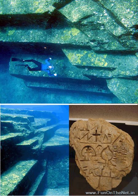
Do you know of any sites that have these types of images available?
I am talking about 3D rendered images from scans of the Earth so we can take a look at some of the highest points of submerged landmasses. I think it would be interesting to see and examine such things from actual 3D scans to consider what might be natural formations and what may be man made structures
I have found 3D rendered images, but the ones I have found have disclaimers about being an artists rendition, or such things.
< - - - edit to add - - - >
This is the closest I could find.
abcnews.go.com...
The article states the radar was able to penetrate clouds, but did not say whether or not it penetrated the oceans to map the ocean floor as well.
[edit on 9/24/2009 by AlienCarnage]
Originally posted by AlienCarnage
Do you know of any sites that have these types of images available?
I am talking about 3D rendered images from scans of the Earth so we can take a look at some of the highest points of submerged landmasses. I think it would be interesting to see and examine such things from actual 3D scans to consider what might be natural formations and what may be man made structures
Here's the problem: (changed to external image link, as image too big)
We haven't used this technique, the only way I know of to produce the type of images you are talking about, on more than a tiny fraction of the sea-bed. Remember that the oceans cover 70% of the planet's surface and you can see the difficulty. It takes serious money to run one of these deep-sea sonar capable research vessels, and nobody is going to be using one to look for man-made structures, it being a fringe area of study.
[edit on 24-9-2009 by Karilla]
reply to post by Karilla
There are so many other reasons for doing so, besides the fringe study of looking for manmade structures. Geological study would be the main reason. If you happen to be able to look at the images for other things, fringe things, would be a bonus but not the main reason.
There are so many other reasons for doing so, besides the fringe study of looking for manmade structures. Geological study would be the main reason. If you happen to be able to look at the images for other things, fringe things, would be a bonus but not the main reason.
reply to post by AlienCarnage
True, but the problem is that most of the coastal mapping, the areas we would be interested in, is still carried out by pin-point depth measurement, it being so much cheaper, and, particularly around the UK coast and I'm sure major portions of the sandy coastal areas of the US, subject to change on a short-term basis.
The USGS is heavily involved in mapping the sea-floor. Whether the resolutions they are working at are fine enough to detect small-scale structures, I don't know.
pubs.usgs.gov...
There is contact information for a couple of guys at the USGS in the above link. They may be able/willing to provide large resolution images of the scans they have made. It should all be public domain after all.
I'm sending an e-mail to him now. I'll let you know what he says.
[edit on 24-9-2009 by Karilla]
[edit on 24-9-2009 by Karilla]
reply to post by Karilla
OMG you have pinpointed in an accurate way in which the whole point of this thread is
hreadin in part=2
[edit on 24-9-2009 by SLAYER69]
OMG you have pinpointed in an accurate way in which the whole point of this thread is
hreadin in part=2
[edit on 24-9-2009 by SLAYER69]
Originally posted by SLAYER69
reply to post by Karilla
OMG you have pinpointed in an accurate way the whole point og this thread
I hope I haven't spoiled any of what's to come in part 2! I may be ok at finding this sort of stuff (I've been interested in it for a long time), but have no hope of laying out the info in any kind of readable form. Anything I can do to help in your endeavours? I have all the time in the world and would be glad to contribute.
reply to post by Karilla
I don’t know if you saw the ABC news link in my earlier edited post, but NASA was working to use Radar to map the land mass,, they did not mention the ocean floor, so I am guessing that it could not penetrate the oceans. If they were able to develop the technology better to be able to not only go through the clouds but the Oceans as well, than we would be able to get the kind of detail I am talking about I think.
My apologies for this slight off topic discussion.
reply to post by AlienCarnage
As far as I understand it, space-based radar can only measure down to the sea's surface. Radar waves are scattered by water, whereas acoustic waves (sonar) perform in a similar way below the water to the way radar operates in air.
I already have an ocean-going boat. If anybody wants to set up a consortium to purchase some side-scan sonar equipment and contribute to fuel costs, we could do our own surveys anywhere we pleased.
The area off the West coast of Ireland is the supposed location of an island/sea-mount that was one of the proposed candidates for the inspiration for the story of Atlantis, Hy-Brasil. I don't know of anyone who has conducted a survey of the area.
Well, they don't hang around at the USGS. I already got a reply!
What a nice bloke!
[edit on 24-9-2009 by Karilla]
As far as I understand it, space-based radar can only measure down to the sea's surface. Radar waves are scattered by water, whereas acoustic waves (sonar) perform in a similar way below the water to the way radar operates in air.
I already have an ocean-going boat. If anybody wants to set up a consortium to purchase some side-scan sonar equipment and contribute to fuel costs, we could do our own surveys anywhere we pleased.
The area off the West coast of Ireland is the supposed location of an island/sea-mount that was one of the proposed candidates for the inspiration for the story of Atlantis, Hy-Brasil. I don't know of anyone who has conducted a survey of the area.
Well, they don't hang around at the USGS. I already got a reply!
Hi Gerry,
Take a look at the following web site:
woodshole.er.usgs.gov...
If you do not find the areas that you might be interested in here, let me know. There may be additional imagery available.
bye, BILL
What a nice bloke!
[edit on 24-9-2009 by Karilla]
reply to post by SLAYER69
Wow have you done your research Slayer, truly a dizzying amount of info to ponder here.
Human writing only goes back so far but our history goes back hundreds of thousands of years, who knows all the struggles and triumphs our species underwent as we made the trek from Africa and explored our planet.
The thing that the flood and Atlantis have in common is that they tell of a time when human civilization was reaching a prime only to have nature bury that civilization and scatter the survivors. I firmly believe that this happened all over the world, advanced cultures were driven from their homes by rising water and much of their culture was left behind only to be told and retold in Deluge myths and stories of lost worlds beneath the waves. I think that if scientists actually started looking at these myths closer and took them not as fantastic fiction but as memories locked in our collective unconscious that have just be retold and altered by time then we would grow much closer to the true origins of civilization and language.
Here you have it very well explained, Atlantis near Greece and Lemuria near India.
All these countless ages of human history really put it in perspective and make you realize how petty our differences truly are when in all honesty we are the same people who made our way out of Africa to cover this big blue planet of ours. One things for sure though, there are more questions then answers
Starred and Flagged
reply to post by Titen-Sxull
I think of Humanity and its religions kind of like siblings arguing over family land after the parents have passed. The fight starts over who gets what between the siblings, animosity arises and is handed down to the next generation, and each generation thereafter only has heard the story as told from their direct lineage. Anything that deviates from the story as told is destroyed by the ones who believe that this is disinformation to disrupt what they were told as true by their ancestors.
If you put this same spin on the way the early world and the places religious wars are fought over, and were able to look at the start of such things, you might see a very similar story to the beginning of the story I stated above.
On place you see this is in Egypt, where Hatshepsut, a female who ruled as king that had her history basically erased from Egyptian records. If this happened here, how many other places erased their history because of things that did not conform; there was a horrific thing that they did not want to be reminded of, etc.
All these countless ages of human history really put it in perspective and make you realize how petty our differences truly are when in all honesty we are the same people who made our way out of Africa to cover this big blue planet of ours. One things for sure though, there are more questions then answers
I think of Humanity and its religions kind of like siblings arguing over family land after the parents have passed. The fight starts over who gets what between the siblings, animosity arises and is handed down to the next generation, and each generation thereafter only has heard the story as told from their direct lineage. Anything that deviates from the story as told is destroyed by the ones who believe that this is disinformation to disrupt what they were told as true by their ancestors.
If you put this same spin on the way the early world and the places religious wars are fought over, and were able to look at the start of such things, you might see a very similar story to the beginning of the story I stated above.
On place you see this is in Egypt, where Hatshepsut, a female who ruled as king that had her history basically erased from Egyptian records. If this happened here, how many other places erased their history because of things that did not conform; there was a horrific thing that they did not want to be reminded of, etc.
reply to post by Karilla
Thanks for sharing the info; I will have to take a look at that site, from my home computer later this evening.
I was surprised by the fast response. That was very cool of him indeed.
Thanks for sharing the info; I will have to take a look at that site, from my home computer later this evening.
I was surprised by the fast response. That was very cool of him indeed.
Originally posted by Karilla
Originally posted by demongoat
the problem with your idea is this, our only source for atlantis is plato and no stories of atlantis are found within egyptian beliefs or texts, there are no myths about cities sinking beneath the waves that i've heard.
Whoever built this lot certainly had some pretty useful building techniques, not replicated anywhere on dry land that we know about. These are solid rock, not built from blocks.
[edit on 24-9-2009 by Karilla]

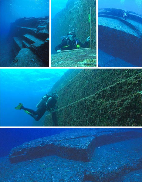
I know about the structures off the japanese coast, some skeptics say it's a natural phenomenon, but thats BS big time. Nature, believe it or not doesn't like making 90 degree corners or straight edges without some help. Those things look like it was terraced for some japanese or their early civilization pagoda. They made reference on the History channel that on land that some japanese castles where put up on rock mounts and then built.
Also I have a link to an author on graham hancocks website that explains as I have already known the process of a people forgetting.
www.grahamhancock.com...
Being able to find sea shells on the top peaks of the Rocky Mountains makes this thread a no-brainer.
There are lost cities under the sea. To state there aren't any known sites, is the biggest hoax going.
As to the information lost in Alexandra's library.... I have seen accounts by the Tibetans where they claim their library has that information and much more, in safe keeping.
I believe much of it is kept in Northern India, away from the Chinese Govt.
As to the thumpers, they will never quit. I guess it does keep a reign on how much of history TPTB can alter to suit their agenda. The problem is that TPTB in most religions also have an agenda.
reply to post by SLAYER69
An outstanding thread!
While I do think putting the myths to the test of the child's game of whisper does not do justice to how the ancients learned by rote, I do think your theory is quite good.
I also do not think they had iPods or cellphones like we do now. I think they were more spiritually developed and had much knowledge in the arts and sciences, especially math.
I look forward to reading your other parts of the theory and from reading what the others have to say.
Originally posted by SLAYER69
Originally posted by Hanslune
Please explain Slayer, the comments you've made are not particularly new nor outrageous. Similar comments can be found within this forum and on a half dozen other ones. What is this 'heat'?
Two words.
Bible Thumpers!
Not worth worrying about then
new topics
-
US food sources declining becoming non edible .
Social Issues and Civil Unrest: 1 hours ago -
Journalism Against Judaism
Middle East Issues: 7 hours ago -
Bibi’s Dilemma
Middle East Issues: 11 hours ago
top topics
-
Bibi’s Dilemma
Middle East Issues: 11 hours ago, 11 flags -
Proof of Cleptocracy
US Political Madness: 15 hours ago, 10 flags -
Journalism Against Judaism
Middle East Issues: 7 hours ago, 4 flags -
US food sources declining becoming non edible .
Social Issues and Civil Unrest: 1 hours ago, 1 flags
active topics
-
President Biden Tells America He is Not Senile and He Knows What The Hell He is Doing.
2024 Elections • 38 • : charlyv -
Murder Suicide Investigation Still Active 4 months later?
Other Current Events • 3 • : worldstarcountry -
Israeli strikes on southern Gaza city of Rafah kill 22, mostly children, as US advances aid package
Middle East Issues • 202 • : AlongCameaSpider -
New House GOP Bill To Send Pro Hamas College Law Breakers to Gaza for 6 Months
Social Issues and Civil Unrest • 124 • : CriticalStinker -
US food sources declining becoming non edible .
Social Issues and Civil Unrest • 12 • : Irishhaf -
Boy Scouts to be renamed next year
Other Current Events • 185 • : AlongCameaSpider -
Time Traveler Caught on Camera?
Paranormal Studies • 39 • : AlongCameaSpider -
-@TH3WH17ERABB17- -Q- ---TIME TO SHOW THE WORLD--- -Part- --44--
Dissecting Disinformation • 912 • : daskakik -
Marjorie Taylor Greene Files Motion to Vacate Speaker Mike Johnson
US Political Madness • 77 • : Zanti Misfit -
Gov Kristi Noem Shot and Killed "Less Than Worthless Dog" and a 'Smelly Goat
2024 Elections • 179 • : AlongCameaSpider