It looks like you're using an Ad Blocker.
Please white-list or disable AboveTopSecret.com in your ad-blocking tool.
Thank you.
Some features of ATS will be disabled while you continue to use an ad-blocker.

Atlantis has been discovered?!
page: 12share:
originally posted by: All Seeing Eye
Occult Magic, is real. They manipulate the mind into believing what isn't real.
"I know magick is real, science is catching up", by ManyMasks
Well since we have two fine fellows who believe in magic. I will place a curse on you then.
If you look at the above it will curse you - the curse will cause you to speak and believe nonsense for thirty-two years.
Enjoy!
(Oh, other folks it's directed at these two folks only everyone else will not un-affected)
edit on 30/6/19 by Hanslune because: Corrected image
originally posted by: Hanslune
originally posted by: All Seeing Eye
Occult Magic, is real. They manipulate the mind into believing what isn't real.
"I know magick is real, science is catching up", by ManyMasks
Well since we have two fine fellows who believe in magic. I will place a curse on you then.
If you look at the above it will curse you - the curse will cause you to speak and believe nonsense for thirty-two years.
Enjoy!
(Oh, other folks it's directed at these two folks only everyone else will not un-affected)
What? All I have left, is 32 years? LOL LOL
originally posted by: All Seeing Eye
originally posted by: Hanslune
originally posted by: All Seeing Eye
Occult Magic, is real. They manipulate the mind into believing what isn't real.
"I know magick is real, science is catching up", by ManyMasks
Well since we have two fine fellows who believe in magic. I will place a curse on you then.
If you look at the above it will curse you - the curse will cause you to speak and believe nonsense for thirty-two years.
Enjoy!
(Oh, other folks it's directed at these two folks only everyone else will not un-affected)
What? All I have left, is 32 years? LOL LOL
Hans figures you'll look at it again, eventually.
Harte
First Ring
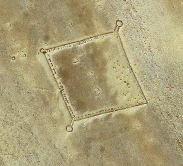
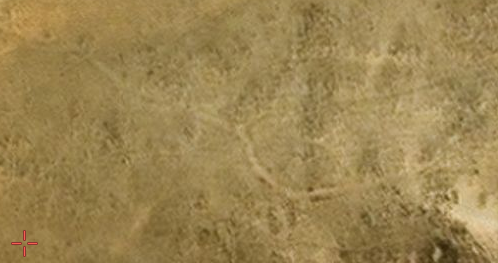
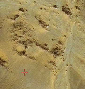
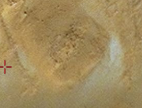
Not much remains of the first ring. There are some rock formations at the south, but I suspect it to be one of those clown cars by one of those secret societies having fun while out chasing goats.
There is this Post on the east side of ring one, but again, I have my doubts if its Pre Flood. 233 X 245 Ft. 4.2 miles from Center.
21° 5'25.85"N 11°27'12.47"W
ADDED:
Just noticed a segment of road that leads to the post. It makes me reconsider if its Pre or Post Flood. It may have been that the post itself blocked the water from washing away that section of road. One of those Hmmm moments.
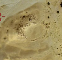
Same location as above.
Not much remains of the first ring. There are some rock formations at the south, but I suspect it to be one of those clown cars by one of those secret societies having fun while out chasing goats.
There is this Post on the east side of ring one, but again, I have my doubts if its Pre Flood. 233 X 245 Ft. 4.2 miles from Center.
21° 5'25.85"N 11°27'12.47"W
ADDED:
Just noticed a segment of road that leads to the post. It makes me reconsider if its Pre or Post Flood. It may have been that the post itself blocked the water from washing away that section of road. One of those Hmmm moments.
Same location as above.
edit on PMMondayMonday stAmerica/ChicagoAmerica/Chicago09712 by All Seeing Eye because: (no reason given)
originally posted by: All Seeing Eye
First Ring
Not much remains of the first ring. There are some rock formations at the south, but I suspect it to be one of those clown cars by one of those secret societies having fun while out chasing goats.
There is this Post on the east side of ring one, but again, I have my doubts if its Pre Flood. 233 X 245 Ft. 4.2 miles from Center.
21° 5'25.85"N 11°27'12.47"W
ADDED:
Just noticed a segment of road that leads to the post. It makes me reconsider if its Pre or Post Flood. It may have been that the post itself blocked the water from washing away that section of road. One of those Hmmm moments.
Same location as above.
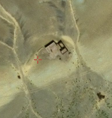
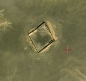
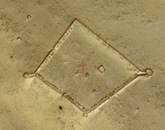
Typical desert fortress, French foreign legion style.
Please supply the location so we can compare.
originally posted by: merka
originally posted by: All Seeing Eye
First Ring
Not much remains of the first ring. There are some rock formations at the south, but I suspect it to be one of those clown cars by one of those secret societies having fun while out chasing goats.
There is this Post on the east side of ring one, but again, I have my doubts if its Pre Flood. 233 X 245 Ft. 4.2 miles from Center.
21° 5'25.85"N 11°27'12.47"W
ADDED:
Just noticed a segment of road that leads to the post. It makes me reconsider if its Pre or Post Flood. It may have been that the post itself blocked the water from washing away that section of road. One of those Hmmm moments.
Same location as above.
Typical desert fortress, French foreign legion style.
Thank you for your input.
a reply to: merka
There are these which are too young to even be considered. But you may be correct in the French guarding the area, for a unknown reason. Or, maybe known to a select few Legionaries.
Defiantly post Flood.
21° 0'43.97"N 11°22'55.80"W
21° 1'31.03"N 11°21'13.92"W
They may very well be, French...
There are these which are too young to even be considered. But you may be correct in the French guarding the area, for a unknown reason. Or, maybe known to a select few Legionaries.
Defiantly post Flood.
21° 0'43.97"N 11°22'55.80"W
21° 1'31.03"N 11°21'13.92"W
They may very well be, French...
First ring cont:
Just found an additional post, and segment of roadway.
Road Section 21° 4'6.45"N 11°22'21.48"W
Post 21° 3'34.26"N 11°26'29.41"W
Just found an additional post, and segment of roadway.
Road Section 21° 4'6.45"N 11°22'21.48"W
Post 21° 3'34.26"N 11°26'29.41"W
originally posted by: merka
originally posted by: All Seeing Eye
First Ring
Not much remains of the first ring. There are some rock formations at the south, but I suspect it to be one of those clown cars by one of those secret societies having fun while out chasing goats.
There is this Post on the east side of ring one, but again, I have my doubts if its Pre Flood. 233 X 245 Ft. 4.2 miles from Center.
21° 5'25.85"N 11°27'12.47"W
ADDED:
Just noticed a segment of road that leads to the post. It makes me reconsider if its Pre or Post Flood. It may have been that the post itself blocked the water from washing away that section of road. One of those Hmmm moments.
Same location as above.
Typical desert fortress, French foreign legion style.
Most probably
www.world-archaeology.com...
www.pinterest.com...
a reply to: Hanslune
Now that you have decided to adjust your approach on the subject Ill respond.
I have not found anything that appears to be a French Fort, other than what I have posted in a previous post, in or around the Eye.
But I did find, 310 miles away, in the Western Sahara, what might be a "French Fort". But that is debatable. Anyone who has a data base of French Forts, and their locations, please share. The French must have records somewhere.
23°36'29.59"N 15°41'50.51"W
If the above is a French Fort then you can see how primitive the ones found in the "Eye" are. To note, if this is a French Fort, it sits just 2 miles away from, you guessed, ancient ruins that have been excavated. 23°35'44.40"N 15°43'15.37"W
In fact the present boarder dispute between Morocco and Western Sahara, very interestingly, are right on top of a ancient boarder that has been reinforced in places. The whole of the Western Sahara is filled with ancient sites that are being claimed by Morocco. The sites Morocco is occupying are cataloged with Archeology catalog numbers that are clearly viewed from the Air.
As always, my Opinion.
Note: having issues posting.
edit on PMWednesdayWednesday rdAmerica/ChicagoAmerica/Chicago0471 by All Seeing Eye because: (no reason
given)
Double Post. Issues with Server, grrrr
edit on PMWednesdayWednesday rdAmerica/ChicagoAmerica/Chicago0571 by All Seeing Eye because: (no reason given)
a reply to: All Seeing Eye
I have a couple of friends that are FFL (French Foreign Legionnaires), they might have the locations written down, but it will be in the field in a commanders book, and not anywhere searchable by you and me. They'll set up an encampment list it's location, and if it gets compromised they'll just do it again somewhere else. The HQ in Lyons won't know where they are at unless they get told. Lyons Fr will trust that their guys will not embarrass the FFL as a whole, and in exchange for that, they give their men a sense of freedom that you wouldn't believe.
All those pictures that you are showing could very well be FFL encampments. We wouldn't know unless we were on the ground there searching those site.
But I did find, 310 miles away, in the Western Sahara, what might be a "French Fort". But that is debatable. Anyone who has a data base of French Forts, and their locations, please share. The French must have records somewhere.
I have a couple of friends that are FFL (French Foreign Legionnaires), they might have the locations written down, but it will be in the field in a commanders book, and not anywhere searchable by you and me. They'll set up an encampment list it's location, and if it gets compromised they'll just do it again somewhere else. The HQ in Lyons won't know where they are at unless they get told. Lyons Fr will trust that their guys will not embarrass the FFL as a whole, and in exchange for that, they give their men a sense of freedom that you wouldn't believe.
All those pictures that you are showing could very well be FFL encampments. We wouldn't know unless we were on the ground there searching those site.
a reply to: Guyfriday
You are absolutly correct. I believe I stated that in the opening post.
Just found this today.
Video: Mauritanian Sahara delights tourists again after years blighted by terror
This change may be in part, or wholly the efforts of the FFL
So, it may be in the near future we get those boots on the ground.
In as far as those "posts" are concerned, I'm still leaning that they are over 8000 years old. And because of the excavations that have been done, (Not publicly released) there is little doubt in my mind that this site is a very ancient site.
Thank you for your input, and interest.
All those pictures that you are showing could very well be FFL encampments. We wouldn't know unless we were on the ground there searching those site.
You are absolutly correct. I believe I stated that in the opening post.
Just found this today.
After years blighted by terror attacks, tourists are beginning to return to Mauritania. Charter flights between Paris and the Mauritanian Sahara resumed in December 2017. Tourists can now re-discover the country’s vast sand dunes and rich cultural heritage, such as Chinguetti, seen as the seventh holy city of Islam. The revival is an economic windfall but also a test for Mauritania, which is keen to stand out from its terror-hit neighbours. FRANCE 24’s Mehdi Meddeb and Stéphane Kenech report.
Video: Mauritanian Sahara delights tourists again after years blighted by terror
This change may be in part, or wholly the efforts of the FFL
So, it may be in the near future we get those boots on the ground.
In as far as those "posts" are concerned, I'm still leaning that they are over 8000 years old. And because of the excavations that have been done, (Not publicly released) there is little doubt in my mind that this site is a very ancient site.
Thank you for your input, and interest.
edit on PMWednesdayWednesday rdAmerica/ChicagoAmerica/Chicago2575 by All Seeing Eye because: (no reason
given)
Dbl post.
edit on PMWednesdayWednesday rdAmerica/ChicagoAmerica/Chicago3675 by All Seeing Eye because: (no reason given)
Center Island.
As mentioned by Plato, if, this site is as old as 11,000, give or take, then that puts in the time of a much more wet weather. During the time when Northwest Africa had running rivers and large lakes.
Its the nature of the Catastrophic water event that keeps us confused. It wasn't a "regular" flood that destroyed the quite large temples and washed away the very modest buildings. Large building stones were used in the construction of the large temples, palace, but not one of them are still in place(unknown presently), and most of them that survived the "Event" were washed out (blown out) the Southern entrance. Well, that is until someone gets in there and starts digging, publicly.
There is no direct evidence to prove this is the "Lost City" of Atlantis, but their is circumstantial evidence, in abundance, to support further investigation in that direction.
Again, someone felt it necessary to erect very large fenced off areas to the south west and south east of the eye in what appears to be flood runoff areas. There is even a preserved village in that area that escaped the brunt force of the flood waters, miraculously.
The large ruins in the Center of the Eye, in my humble opinion.
The first, at the center are what appear to be building blocks or the remnants of the pillar of laws( pillar of orichalcum ). There may be a storage shed also.
21° 7'32.45"N 11°23'55.48"W
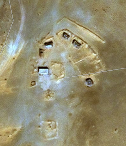
General Area. You will note, and not very visible a line that runs NW by SE. This line appears to be something embedded in the soil. It is to the right of center.
It is not consistent with the bedrock.
Poseidon Temple. 900 ft X 450 ft.
21° 8'22.49"N 11°24'35.41"W
2 large Buildings
21° 8'2.35"N 11°23'10.35"W
U shaped Building. Note the 90 deg corner.
21° 8'26.82"N 11°23'31.21"W
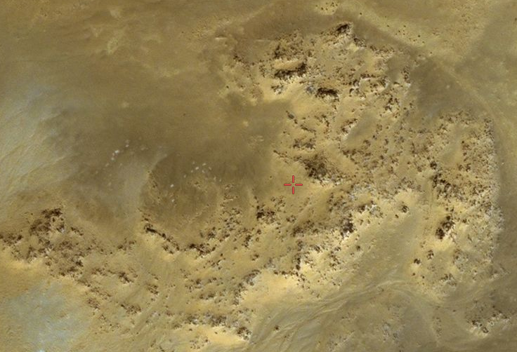
Right next to, to the right is a section of ally ways similar to the ally ways in the "Suburb" 21° 0'19.61"N 11°34'36.89"W
21° 8'28.28"N 11°23'20.74"W
Temple 140ft X 220ft.
21° 7'44.44"N 11°24'54.31"W
Other large Building 450ft X 200ft
21° 7'30.23"N 11°25'7.29"W
Small Circular area. 80ft X 80ft
21° 7'49.51"N 11°25'14.43"W
Circular area at East Entrance 280ft X 200ft
21° 7'28.34"N 11°22'48.45"W
I suspect these are the foundations which other rubble washed up on, maybe even protecting the foundation stones. In reality, it is only a list to start the dig...
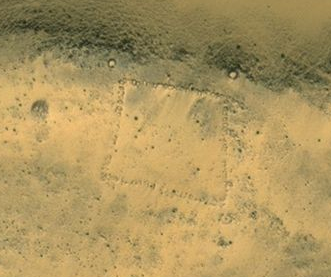
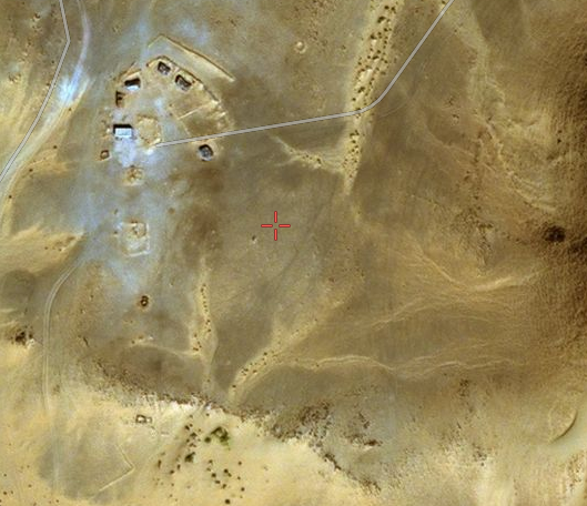
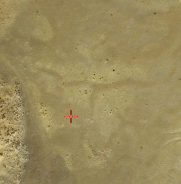
It may be possible, upon reconsidering, this is a original post. I noticed that their is a ridge that could have diverted the water, over this post, generally leaving it untouched. 240ft X 213ft.
21° 7'22.28"N 11°22'23.20"W
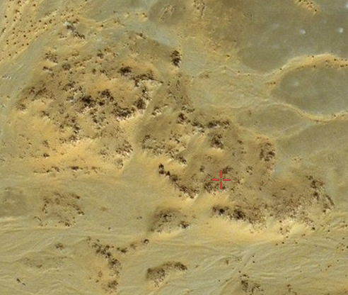
For those who insist this can not be "Atlantis" because it isn't under water, it is very obvious, it was under water! It just didn't stay that way.
For a hint at the type of flood this was, notice the bedrock has been stripped of all of its millions of years of Patina, exposing the layers of bedrock, like new. Yes, scoured..
21° 8'33.76"N 11°24'52.23"W
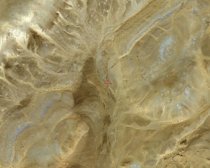
The Southwest quadrant of the Island has been stripped clean of any signs.
As mentioned by Plato, if, this site is as old as 11,000, give or take, then that puts in the time of a much more wet weather. During the time when Northwest Africa had running rivers and large lakes.
Its the nature of the Catastrophic water event that keeps us confused. It wasn't a "regular" flood that destroyed the quite large temples and washed away the very modest buildings. Large building stones were used in the construction of the large temples, palace, but not one of them are still in place(unknown presently), and most of them that survived the "Event" were washed out (blown out) the Southern entrance. Well, that is until someone gets in there and starts digging, publicly.
There is no direct evidence to prove this is the "Lost City" of Atlantis, but their is circumstantial evidence, in abundance, to support further investigation in that direction.
Again, someone felt it necessary to erect very large fenced off areas to the south west and south east of the eye in what appears to be flood runoff areas. There is even a preserved village in that area that escaped the brunt force of the flood waters, miraculously.
The large ruins in the Center of the Eye, in my humble opinion.
The first, at the center are what appear to be building blocks or the remnants of the pillar of laws( pillar of orichalcum ). There may be a storage shed also.
21° 7'32.45"N 11°23'55.48"W
General Area. You will note, and not very visible a line that runs NW by SE. This line appears to be something embedded in the soil. It is to the right of center.
It is not consistent with the bedrock.
Poseidon Temple. 900 ft X 450 ft.
21° 8'22.49"N 11°24'35.41"W
2 large Buildings
21° 8'2.35"N 11°23'10.35"W
U shaped Building. Note the 90 deg corner.
21° 8'26.82"N 11°23'31.21"W
Right next to, to the right is a section of ally ways similar to the ally ways in the "Suburb" 21° 0'19.61"N 11°34'36.89"W
21° 8'28.28"N 11°23'20.74"W
Temple 140ft X 220ft.
21° 7'44.44"N 11°24'54.31"W
Other large Building 450ft X 200ft
21° 7'30.23"N 11°25'7.29"W
Small Circular area. 80ft X 80ft
21° 7'49.51"N 11°25'14.43"W
Circular area at East Entrance 280ft X 200ft
21° 7'28.34"N 11°22'48.45"W
I suspect these are the foundations which other rubble washed up on, maybe even protecting the foundation stones. In reality, it is only a list to start the dig...
It may be possible, upon reconsidering, this is a original post. I noticed that their is a ridge that could have diverted the water, over this post, generally leaving it untouched. 240ft X 213ft.
21° 7'22.28"N 11°22'23.20"W
For those who insist this can not be "Atlantis" because it isn't under water, it is very obvious, it was under water! It just didn't stay that way.
For a hint at the type of flood this was, notice the bedrock has been stripped of all of its millions of years of Patina, exposing the layers of bedrock, like new. Yes, scoured..
21° 8'33.76"N 11°24'52.23"W
The Southwest quadrant of the Island has been stripped clean of any signs.
Dbl post
edit on PMWednesdayWednesday rdAmerica/ChicagoAmerica/Chicago0478 by All Seeing Eye because: (no reason given)
originally posted by: All Seeing Eye
a reply to: Hanslune
Now that you have decided to adjust your approach on the subject Ill respond.
Sorry I was posting info for the other fellow - you're under a curse to post nonsense for the next 32 years - and it appears you are doing so!
originally posted by: Hanslune
originally posted by: All Seeing Eye
a reply to: Hanslune
Now that you have decided to adjust your approach on the subject Ill respond.
Sorry I was posting info for the other fellow - you're under a curse to post nonsense for the next 32 years - and it appears you are doing so!
In a perverted sort of way, I take that as a compliment. But then again, you know nothing of my commitment, and why. Well, maybe you do, but that defiantly belongs in the "Twilight Zone" LOL LOL.
But to be honest, in order to "honestly" understand the "insane" you must enter their world. And if a person refuses to do that, they just are not being honest to themselves. Enough of philosophy.
I want you to stare at the pile of rocks depicted at "Other large Building 450ft X 200ft 21° 7'30.23"N 11°25'7.29"W "
To the left is a large square, and in the upper right, is a 90 deg angle. Do you suppose that is the corner of the building, where the building blocks are visable? No, I suppose not, that would require you to look past your own programing. Sorry, it was too much to ask. It would only take two feet of sand to be removed, to change the world.
Ya know, I used to be a normy like you, till, I saw the light....
Maybe one day, everyone, will see the light.
Sincerly, thank you for, your "Curse", and your reply.
Some of us work weekends, and holidays, not for the pay, but for the love.
Now go light a firecracker............ Do one for me too......
As stated in the opening post, there must have been a network of suppliers for the Island City. Venturing to Cape Verde did not leave me guessing!
I will be posting ancient ruins on these Islands, but first some research time
Cape Verde Islands
THE GORGADES
History of Cape Verde
I will be posting ancient ruins on these Islands, but first some research time
In 1949, Capt. H.P.C. Andersen, who worked for a Danish salvage company, wrote a very brief letter to Egerton Sykes‘ Atlantis Research journal with the self-explanatory title of Atlantean Traces in the Cape Verde Islands(a). In it, he recounts coming across a harbour in Boavista Island, the bottom of which was completely covered in sheets of concrete about a yard square, reminiscent of a market place.
Cape Verde Islands
THE GORGADES were a tribe inhabiting certain islands off the Atlantic coast of Africa whose womanfolk were entirely covered in hair.
The tribe perhaps derives from ancient traveller's accounts of some species of monkey or ape. They are perhaps the same as the Satyroi of the Satyrides Isles.
THE GORGADES
According to Pliny the Elder, the Greek Xenophon of Lampsacus states that the Gorgades (Cape Verde) are situated two days from "Hesperu Ceras" - today called Cap-Vert, the westernmost part of the African continent. According to Pliny the Elder and his citation by Gaius Julius Solinus, the sea voyage time from Atlantis crossing the Gorgades to the islands of the Ladies of the West (Hesperides) is around 40 days.
History of Cape Verde
new topics
-
Chris Cuomo, who pushed vaccine shots on CNN, admits Moderna vaccine destroyed his health
Mainstream News: 1 hours ago -
History Shows; Many Crisis Are Artificial I'm Order To Enslave People
Political Conspiracies: 1 hours ago -
StormyD Accused of Falsification of Business Records to Hide Money From Trump
US Political Madness: 11 hours ago
top topics
-
Judge Postpones Trump Classified Docs Trial INDEFINITELY
US Political Madness: 14 hours ago, 33 flags -
StormyD Accused of Falsification of Business Records to Hide Money From Trump
US Political Madness: 11 hours ago, 21 flags -
To all ATS members of Faith - Prayer request
Religion, Faith, And Theology: 17 hours ago, 13 flags -
Chris Cuomo, who pushed vaccine shots on CNN, admits Moderna vaccine destroyed his health
Mainstream News: 1 hours ago, 3 flags -
History Shows; Many Crisis Are Artificial I'm Order To Enslave People
Political Conspiracies: 1 hours ago, 1 flags
active topics
-
Judge Postpones Trump Classified Docs Trial INDEFINITELY
US Political Madness • 45 • : CarlLaFong -
StormyD Accused of Falsification of Business Records to Hide Money From Trump
US Political Madness • 35 • : network dude -
The Acronym Game .. Pt.3
General Chit Chat • 7810 • : bally001 -
Shocking moment four men 'try to force Jewish pedestrian into car boot' in North London
Breaking Alternative News • 97 • : AllisVibration -
Chris Cuomo, who pushed vaccine shots on CNN, admits Moderna vaccine destroyed his health
Mainstream News • 5 • : network dude -
Russia Ukraine Update Thread - part 3
World War Three • 5764 • : gortex -
Russia police launch major manhunt after troops massacred by comrade in occupied Ukraine
Other Current Events • 18 • : andy06shake -
Candidate TRUMP Now Has Crazy Judge JUAN MERCHAN After Him - The Stormy Daniels Hush-Money Case.
Political Conspiracies • 1410 • : Lazy88 -
History Shows; Many Crisis Are Artificial I'm Order To Enslave People
Political Conspiracies • 0 • : ADVISOR -
"We're All Hamas" Heard at Columbia University Protests
Social Issues and Civil Unrest • 320 • : FlyersFan