It looks like you're using an Ad Blocker.
Please white-list or disable AboveTopSecret.com in your ad-blocking tool.
Thank you.
Some features of ATS will be disabled while you continue to use an ad-blocker.

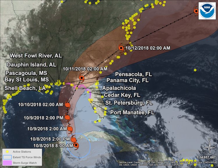
Hurricane Michael May Hit Pan Handle
page: 3share:
originally posted by: Sabrechucker
a reply to: roadgravel
That's good to hear. what's a cold front there 70
first of the fall. Won't be much. It will keep it out of the 90s.
edit on 10/9/2018 by roadgravel because: (no reason given)
a reply to: Sabrechucker
I'm still new to this area , most roads around here are only a few feet above SL, and flood almost monthly. The temp seems cooler than normal, at79, I'll check back tomorrow.
I'm still new to this area , most roads around here are only a few feet above SL, and flood almost monthly. The temp seems cooler than normal, at79, I'll check back tomorrow.
The NOAA hurricane hunter is out there now...they found lower pressure ~949mb and winds close to 130mph. This storm is on the verge of becoming a cat
4.
edit on 9-10-2018 by jrod because: Y
originally posted by: jrod
The NOAA hurricane hunter is out there now...the found lower pressure ~949mb and winds close to 130mph. This storm is on the verge of becoming a cat 4.
I figured after it goes through the night it was going to intensify quite a bit. Looks like it will happen.
I hope the people on the coast did leave.
It is a cat 4 now. Tommorow will be a rough day for the panhandle.
a reply to: Sabrechucker
Damn, 150 mph sustained winds now. Whats the cat 5 designation?
Thanks for all the updates Saber.
Here is the feed I got that info from.
Damn, 150 mph sustained winds now. Whats the cat 5 designation?
Thanks for all the updates Saber.
Here is the feed I got that info from.
a reply to: stosh64
I just looked it up.
NHC
Stay safe everyone
I just looked it up.
NHC
4 (major) 130-156 mph 113-136 kt 209-251 km/h
Catastrophic damage will occur: Well-built framed homes can sustain severe damage with loss of most of the roof structure and/or some exterior walls. Most trees will be snapped or uprooted and power poles downed. Fallen trees and power poles will isolate residential areas. Power outages will last weeks to possibly months. Most of the area will be uninhabitable for weeks or months.
5 (major) 157 mph or higher 137 kt or higher 252 km/h or higher
Catastrophic damage will occur: A high percentage of framed homes will be destroyed, with total roof failure and wall collapse. Fallen trees and power poles will isolate residential areas. Power outages will last for weeks to possibly months. Most of the area will be uninhabitable for weeks or months.
Stay safe everyone
originally posted by: stosh64
a reply to: stosh64
I just looked it up.
NHC
4 (major) 130-156 mph 113-136 kt 209-251 km/h
Catastrophic damage will occur: Well-built framed homes can sustain severe damage with loss of most of the roof structure and/or some exterior walls. Most trees will be snapped or uprooted and power poles downed. Fallen trees and power poles will isolate residential areas. Power outages will last weeks to possibly months. Most of the area will be uninhabitable for weeks or months.
5 (major) 157 mph or higher 137 kt or higher 252 km/h or higher
Catastrophic damage will occur: A high percentage of framed homes will be destroyed, with total roof failure and wall collapse. Fallen trees and power poles will isolate residential areas. Power outages will last for weeks to possibly months. Most of the area will be uninhabitable for weeks or months.
Stay safe everyone
I don't know that area too well but, I don't think that area is built up quite the same as some east coast Florida cities.
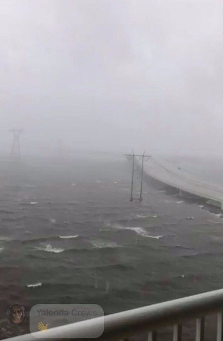
May Have lost the Live stream above, getting very nasty there.
Here's another
God Bless
Here's another
God Bless
NOAA Satellites
Verified account
@NOAASatellites
24m24 minutes ago
More
The core of #HurricaneMichael, seen in this #GOESEast imagery, is nearing the coast of the Florida Panhandle between St. Vincent Island and Panama City. An extreme wind warning has been issued for the eyewall. Latest: go.usa.gov...
twitter.com...
a reply to: Sabrechucker
Incredible how this continued to strengthen up until landfall. This is almost on par with Camille or Andrew.
Hopefully those in the eyewall will stay safe.
Incredible how this continued to strengthen up until landfall. This is almost on par with Camille or Andrew.
Hopefully those in the eyewall will stay safe.
a reply to: Sabrechucker
"Michael no has a deeper Pressure than Andrew at landfall." Andrew looked like a F5 tornado about 50 miles wide went through, my God.
Damn, looks like Mexico Beach is about to get leveled.
Thoughts and prayers to all in the path of this beast.
"Michael no has a deeper Pressure than Andrew at landfall." Andrew looked like a F5 tornado about 50 miles wide went through, my God.
Damn, looks like Mexico Beach is about to get leveled.
Thoughts and prayers to all in the path of this beast.
edit on 10 10 2018 by stosh64 because: (no reason given)
new topics
-
What is the white pill?
Philosophy and Metaphysics: 20 minutes ago -
Mike Pinder The Moody Blues R.I.P.
Music: 1 hours ago -
Putin, Russia and the Great Architects of the Universe
ATS Skunk Works: 4 hours ago -
A Warning to America: 25 Ways the US is Being Destroyed
New World Order: 8 hours ago
top topics
-
President BIDEN's FBI Raided Donald Trump's Florida Home for OBAMA-NORTH KOREA Documents.
Political Conspiracies: 14 hours ago, 31 flags -
A Warning to America: 25 Ways the US is Being Destroyed
New World Order: 8 hours ago, 14 flags -
Is AI Better Than the Hollywood Elite?
Movies: 16 hours ago, 4 flags -
Mike Pinder The Moody Blues R.I.P.
Music: 1 hours ago, 2 flags -
Maestro Benedetto
Literature: 15 hours ago, 1 flags -
Putin, Russia and the Great Architects of the Universe
ATS Skunk Works: 4 hours ago, 1 flags -
What is the white pill?
Philosophy and Metaphysics: 20 minutes ago, 1 flags
active topics
-
A Warning to America: 25 Ways the US is Being Destroyed
New World Order • 20 • : jidnum2 -
President BIDEN's FBI Raided Donald Trump's Florida Home for OBAMA-NORTH KOREA Documents.
Political Conspiracies • 23 • : xuenchen -
Gaza Terrorists Attack US Humanitarian Pier During Construction
Middle East Issues • 62 • : CarlLaFong -
Meadows, Giuliani Among 11 Indicted in Arizona in Latest 2020 Election Subversion Case
Mainstream News • 17 • : network dude -
New whistleblower Jason Sands speaks on Twitter Spaces last night.
Aliens and UFOs • 69 • : Ophiuchus1 -
Putin, Russia and the Great Architects of the Universe
ATS Skunk Works • 16 • : CristianVictoria -
Alternate Electors vs Fake Electors - What is the Difference.
2024 Elections • 123 • : frogs453 -
Massachusetts Drag Queen Leads Young Kids in Free Palestine Chant
Social Issues and Civil Unrest • 17 • : ToneD -
Hate makes for strange bedfellows
US Political Madness • 51 • : network dude -
The Acronym Game .. Pt.3
General Chit Chat • 7755 • : F2d5thCavv2