It looks like you're using an Ad Blocker.
Please white-list or disable AboveTopSecret.com in your ad-blocking tool.
Thank you.
Some features of ATS will be disabled while you continue to use an ad-blocker.

Hurricane Michael May Hit Pan Handle
page: 2share:
The water is up 13 inches here in Biloxi, CederLake rd( 100yrds north of I10 closed because of high water. I hope everyone is safe. This storm could
get bad.
Up to 120mph as of 4pm CDT and the pressure is down to 957mb.
Most of the pro meteorologists agree that further strengthening is likely, as do the computer models. This could be a cat 4 at landfall.
Those in the warning areas need to be ready and if they have not evacuated from an evacuation do so ASAP.
The storm surge alone could be catastrophic on the east side of the storm on top of the 130mph+ wind that are becoming more likely.
edit on
9-10-2018 by jrod because: (no reason given)
edit on 9-10-2018 by jrod because: Aff
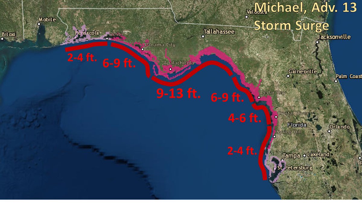
National Hurricane Center Verified account @NHC_Atlantic Follow Follow @NHC_Atlantic More #Michael is expected to produce a destructive & life-threatening storm surge along portions of the Florida Panhandle, Big Bend & Nature Coast on Wednesday & Wed night. The worst storm surge is expected to be between Mexico Beach & Keaton Beach with 9-13' of inundation possible.
Here is a live stream
edit on 9-10-2018 by Sabrechucker because: edit
a reply to: Sabrechucker
Katrina was a cat 5 before landfall, but weakened to a cat 3 before landfall. The surge levels were on cat 5 levels because of how strong it was prior to landfall.
Katrina was a cat 5 before landfall, but weakened to a cat 3 before landfall. The surge levels were on cat 5 levels because of how strong it was prior to landfall.
I was just looking at data from the hurricane hunters, tge pressure is down to 952mb. This means Michael is still strengthening.
a reply to: Sabrechucker
Not really...if anything it could help weaken the storm with upwelling however Michael will moving fast enough to make this a non issue.
There is already coastal flooding from the storm. We had some minor flooding in Key West and it appears almost all of the west coast of Florida is experience some minor surge...some places worse that others.
a reply to: Sabrechucker
Biloxi should be on the west side and will not have the strong onshore winds to drive in the surge...they will have offshore winds and may even see receding water levels when the offshores start blowing.
Biloxi should be on the west side and will not have the strong onshore winds to drive in the surge...they will have offshore winds and may even see receding water levels when the offshores start blowing.
edit on 9-10-2018 by jrod because: D
a reply to: Sabrechucker
The are getting an onshore/sideshow flow plus the swells. As the storm approaches they will get a northesterly wind that should stop the surge.
Right now they are experiencing an east wind which is mostly side shore and enough on top of the swells to cause a small surge.
The are getting an onshore/sideshow flow plus the swells. As the storm approaches they will get a northesterly wind that should stop the surge.
Right now they are experiencing an east wind which is mostly side shore and enough on top of the swells to cause a small surge.
a reply to: Sabrechucker
I might have quick to say that...the offshore winds will help but the high swell/surf could still keep water levels high.
Unlike Irma in the Tampa/ west coast of Florida, Michael has had plenty of time to stir up the gulf and has massive waves as well as very strong winds in all quadrants which will send those swells in all directions...Irma was a lopsided storm when it made landfall around Fort Myers last year.
originally posted by: Sabrechucker
a reply to: jrod
... I was looking at some news in Texas and they seem a little concerned about flooding.
A cold front has been pushing through the state causing lots of rain. Helping to keep the storm out to the east.
new topics
-
VP's Secret Service agent brawls with other agents at Andrews
Mainstream News: 3 minutes ago -
Sunak spinning the sickness figures
Other Current Events: 44 minutes ago -
Nearly 70% Of Americans Want Talks To End War In Ukraine
Political Issues: 55 minutes ago -
Late Night with the Devil - a really good unusual modern horror film.
Movies: 2 hours ago -
Cats Used as Live Bait to Train Ferocious Pitbulls in Illegal NYC Dogfighting
Social Issues and Civil Unrest: 4 hours ago -
The Good News According to Jesus - Episode 1
Religion, Faith, And Theology: 6 hours ago -
HORRIBLE !! Russian Soldier Drinking Own Urine To Survive In Battle
World War Three: 8 hours ago -
Bobiverse
Fantasy & Science Fiction: 10 hours ago -
Florida man's trip overseas ends in shock over $143,000 T-Mobile phone bill
Social Issues and Civil Unrest: 11 hours ago
top topics
-
Florida man's trip overseas ends in shock over $143,000 T-Mobile phone bill
Social Issues and Civil Unrest: 11 hours ago, 8 flags -
SETI chief says US has no evidence for alien technology. 'And we never have'
Aliens and UFOs: 14 hours ago, 7 flags -
Cats Used as Live Bait to Train Ferocious Pitbulls in Illegal NYC Dogfighting
Social Issues and Civil Unrest: 4 hours ago, 7 flags -
This is our Story
General Entertainment: 17 hours ago, 4 flags -
Former Labour minister Frank Field dies aged 81
People: 13 hours ago, 4 flags -
Bobiverse
Fantasy & Science Fiction: 10 hours ago, 3 flags -
Late Night with the Devil - a really good unusual modern horror film.
Movies: 2 hours ago, 2 flags -
HORRIBLE !! Russian Soldier Drinking Own Urine To Survive In Battle
World War Three: 8 hours ago, 2 flags -
Nearly 70% Of Americans Want Talks To End War In Ukraine
Political Issues: 55 minutes ago, 1 flags -
Sunak spinning the sickness figures
Other Current Events: 44 minutes ago, 0 flags
active topics
-
President BIDEN Vows to Make Americans Pay More Federal Taxes in 2025 - Political Suicide.
2024 Elections • 115 • : budzprime69 -
VP's Secret Service agent brawls with other agents at Andrews
Mainstream News • 0 • : SchrodingersRat -
HORRIBLE !! Russian Soldier Drinking Own Urine To Survive In Battle
World War Three • 25 • : Freeborn -
Definitive 9.11 Pentagon EVIDENCE.
9/11 Conspiracies • 422 • : Zanti Misfit -
Nearly 70% Of Americans Want Talks To End War In Ukraine
Political Issues • 4 • : budzprime69 -
Breaking Baltimore, ship brings down bridge, mass casualties
Other Current Events • 482 • : IndieA -
How ageing is" immune deficiency"
Medical Issues & Conspiracies • 30 • : annonentity -
Remember These Attacks When President Trump 2.0 Retribution-Justice Commences.
2024 Elections • 55 • : Zanti Misfit -
SETI chief says US has no evidence for alien technology. 'And we never have'
Aliens and UFOs • 36 • : anthelion -
Truth Social goes public, be careful not to lose your money
Mainstream News • 124 • : lilzazz