It looks like you're using an Ad Blocker.
Please white-list or disable AboveTopSecret.com in your ad-blocking tool.
Thank you.
Some features of ATS will be disabled while you continue to use an ad-blocker.

Looks Like Hurricane MARIA Will Soon Be a Threat.
page: 6share:
a reply to: EchoesInTime
Lee is trying to re-energize itself as well . It died down but has a low chance of perking back up. Hopefully it stays ckear of the mainland.
www.nhc.noaa.gov...
Lee is trying to re-energize itself as well . It died down but has a low chance of perking back up. Hopefully it stays ckear of the mainland.
As of 2:00 pm EDT Tue Sep 19 2017 ...
A small low pressure area, the remnants of Lee, is producing
disorganized shower activity about midway between the Cabo Verde
Islands and the Leeward Islands. Environmental conditions could
become marginally conducive for redevelopment of a tropical cyclone
by the weekend while the system moves northwestward to northward
over the central Atlantic Ocean.
* Formation chance through 48 hours...low...10 percent.
* Formation chance through 5 days...low...20 percent.
www.nhc.noaa.gov...
Maria's track still appears to want to stay ckear of Florida. I imagine it will find its way over to northeastern US later in the week.
Still cat 5
www.nhc.noaa.gov...
Still cat 5
www.nhc.noaa.gov...
edit on 19-9-2017 by violet because: (no reason
given)
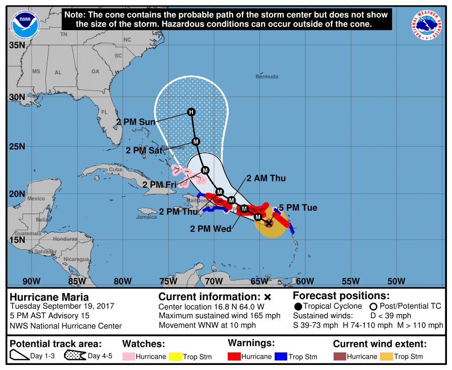
Hurricane MARIA
As of 0500 PM AST Tue Sep 19 (Advisory # 15)
Saffir-Simpson Wind Scale: Category 5
Maximum Sustained Winds: 145 knots; 165 mph
Minimum Central Pressure: 916 mb
Located at: 16.8N 64.0W
Movement: west-northwest at 9 knots; 10 mph
edit on 19-9-2017 by violet because: (no reason given)
edit on 19-9-2017 by violet because: (no reason given)
a reply to: violet
Thank-you for that updated map. Hopefully Maria won't stay on the left side of the cone like Irma did. Staying left helped the U.S. when Irma interacted with Cuba. If Maria gets too wound up, she too could stay left/west and head towards North Carolina.
Thank-you for that updated map. Hopefully Maria won't stay on the left side of the cone like Irma did. Staying left helped the U.S. when Irma interacted with Cuba. If Maria gets too wound up, she too could stay left/west and head towards North Carolina.
I think it depends which side of Puerto rico it hits. Further southwest it hits the more west the track gets moved. If it then moves to west side of
Haiti...watch out.
originally posted by: Guardian10
a reply to: carewemust
They do don't they. It's been quite the month for disasters this year.
I started this thread to poke fun at Anna Navarro, www.abovetopsecret.com... , but she might be on to something!
originally posted by: sligtlyskeptical
I think it depends which side of Puerto rico it hits. Further southwest it hits the more west the track gets moved. If it then moves to west side of Haiti...watch out.
I've never been to Puerto Rico. Out of curiosity, I just did a Google search to see what the landscape and homes are like. What I found, blew me away.
Photo of San Juan: c8.alamy.com...
I mistakenly believed that Puerto Rico was like Barbuda...filled with old slab homes and raggedy roads. A CAT-5 to San Juan will be devastating. It looks like Miami. Hopefully, San Juan will dodge-the-bullet like Miami did!
a reply to: carewemust
They were saying the US model has it more left. Hopefully not.
Maria is showing no signs of weakening as it approaches Puerto Rico. That the more populated areas in the northeast are gonna get the northeast eye wall.
Prayers to them and the other islands in its path
They were saying the US model has it more left. Hopefully not.
Maria is showing no signs of weakening as it approaches Puerto Rico. That the more populated areas in the northeast are gonna get the northeast eye wall.
Prayers to them and the other islands in its path
edit on 19-9-2017 by violet because: (no reason given)
It's strengthening. Pressure has dropped, winds intensified
www.nhc.noaa.gov...
...EYE OF CATEGORY 5 HURRICANE MARIA MOVING CLOSER TO ST CROIX IN THE U.S. VIRGIN ISLANDS
8:00 PM AST Tue Sep 19
Location: 17.0°N 64.2°W
Moving: WNW at 10 mph
Min pressure: 909 mb
Max sustained: 175 mph
www.nhc.noaa.gov...
NHC has forecast winds at Arecibo, Puerto Rico to be 156 MPH. I wonder if the array can take that kind of wind.
Prayers for everyone on Puerto Rico tonight as Maria wind forecast has majority of island getting 150+ MPH winds with higher elevations getting nearer 185 mph.
Very few structures are designed for this and I fear for peoples safety.
Prayers for everyone on Puerto Rico tonight as Maria wind forecast has majority of island getting 150+ MPH winds with higher elevations getting nearer 185 mph.
Very few structures are designed for this and I fear for peoples safety.
Loooks like Puerto Rico will suffer some landslides as well.
Wunderground
Thanks to DTOM
Maria will likely be a catastrophic Category 5 or high-end Category 4 storm when it hits the U.S. Virgin Islands and Puerto Rico on Wednesday morning. Preliminary reports out of Dominica indicate that Maria likely did catastrophic damage there. The northern eyewall of Maria also grazed the southwest corner of Guadaloupe Island on Monday night, and heavy damage was reported there. The core of the hurricane missed Montserrat, Saba, and St. Kitts and Nevis, but these islands have been experiencing sustained tropical storm-force winds and heavy rain squalls.....
......A track crossing Puerto Rico from southeast to northwest will bring torrential rainfall and the risk of landslides to both northern- and southern-facing mountainsides.
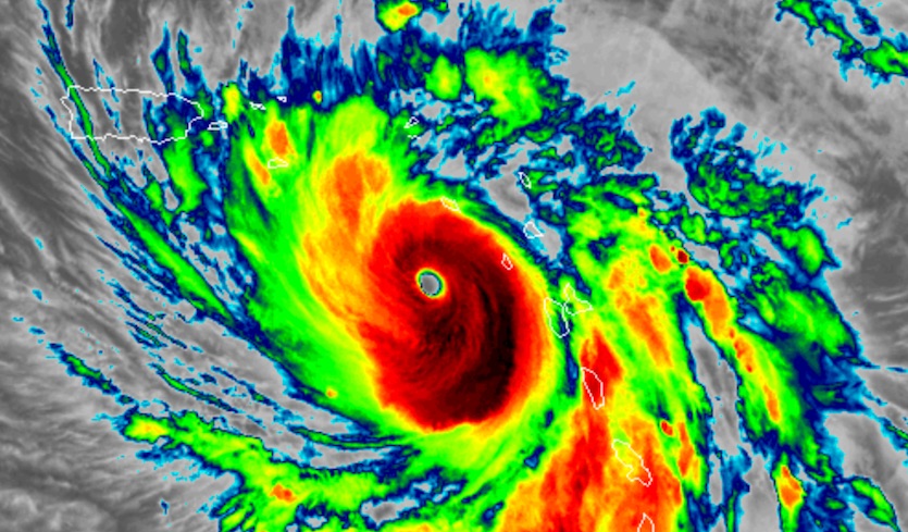
The dreaded "pinhole" eye
Maria developed a tiny “pinhole” eye during its rapid intensification burst on Monday, with a diameter of 8 nautical miles (nm). The hurricane has maintained a small eye so far on Tuesday, with the diameter fluctuating between 7 nm and 10 nm (10 nm = 11.5 miles). Hurricanes that develop pinhole eyes often intensify into some of the strongest storms we observe, since they concentrate their wind energy around a narrow ring surrounding the tiny eye. These small eyes tend to be unstable, resulting in an eyewall replacement cycle (ERC) shortly after the pinhole eye is observed. Some other examples of tropical cyclones with pinhole eyes with a diameter less than 10 nm (thanks go to Michael Cavaliere, Howard Diamond, and Boris Konon):
Wunderground
Thanks to DTOM
edit on 19-9-2017 by violet because: (no reason given)
originally posted by: opethPA
originally posted by: Flanker86
Hurrican Maria was manufactured by Germany and The Netherlands, to destroy the Caribbean as much as possible and to create migration crises in the US, especially in Florida. It looks like all the EU can do is to foment illegal mass immigration anywhere in the world. The Vatican and the UK are fully involved in this as well.
Got it so now any country can create weather and not just any weather but hurricane level weather..
Damn it, I thought we were the only ones who had this technology. Thanks Obama.
a reply to: carewemust
Are you talkin about all those little islands it passes over in like 10 minutes and take up a fraction of a percent of the storm's area? That doesn't seem surprising to me.
Are you talkin about all those little islands it passes over in like 10 minutes and take up a fraction of a percent of the storm's area? That doesn't seem surprising to me.
Having experienced Irma living in Central Florida, I was impressed
byt the 100 mile per hour winds that were whipping over my eaves,
threatening to rip the roof off. I t was unusually intense and long
lasting, like an earthquake that lasts for hours. It wasn't even slowed
by tracking up from Miami, and was wider than the state is.
My first superstorm and man was it scary.
a reply to: carewemust
Latest on Maria
Windfield has grown in size. Hurricane force winds will cover a greater area
www.nhc.noaa.gov...
BULLETIN
Hurricane Maria Advisory Number 16
NWS National Hurricane Center Miami FL AL152017
1100 PM AST Tue Sep 19 2017
...EYE OF POTENTIALLY CATASTROPHIC CATEGORY 5 HURRICANE MARIA
NEARING ST. CROIX...
...CORE EXPECTED TO REACH SOUTHEASTERN PUERTO RICO WEDNESDAY
MORNING...
Windfield has grown in size. Hurricane force winds will cover a greater area
ION AND 48-HOUR OUTLOOK
------------------------------
At 1100 PM AST (0300 UTC), the center of Hurricane Maria was located
near latitude 17.3 North, longitude 64.7 West. Maria is moving
toward the west-northwest near 10 mph (17 km/h). A west-northwest
to northwest motion is expected to continue through Wednesday
night, followed by a northwestward motion on Thursday. On the
forecast track, the eye of Maria will move near or over St. Croix
in the U.S. Virgin Islands within the next couple of hours, then
cross Puerto Rico on Wednesday, and pass just north of the
northeast coast of the Dominican Republic Wednesday night and
Thursday.
Maximum sustained winds are near 175 mph (280 km/h) with higher
gusts. Maria is a potentially catastrophic category 5 hurricane on
the Saffir-Simpson Hurricane Wind Scale. Some fluctuations in
intensity could occur before the hurricane reaches Puerto Rico, but
Maria is forecast to remain an extremely dangerous category 4 or 5
hurricane as it moves near or over the Virgin Islands and Puerto
Rico. Slow weakening is expected after the hurricane emerges over
the Atlantic north of Puerto Rico and the Dominican Republic.
Reports from reconnaissance aircraft indicate that the area of
hurricane-force winds has increased in size. Hurricane-force winds
now extend outward up to 60 miles (95 km) from the center and
tropical-storm-force winds extend outward up to 150 miles (240 km).
The estimated minimum central pressure is 909 mb (26.85 inches).
www.nhc.noaa.gov...
originally posted by: face23785
a reply to: carewemust
Are you talkin about all those little islands it passes over in like 10 minutes and take up a fraction of a percent of the storm's area? That doesn't seem surprising to me.
Just like the projections we're seeing for Maria, the projections for Irma showed her weakening to the west of Puerto Rico. Didn't happen. But, hopefully the strength reduction projection for Irma proves to be correct.
Latest Strength Projection Map: www.wfmynews2.com...
a reply to: carewemust
Hurricanes enemies are the mountains of the big Antilles when they are in the Caribbean.
Usually PR is the first Island with mountains that will start weakening the Hurricanes.
Today I was able to talk to my parents in Rio Grande, that is where el Yunque is located, but so far cannot communicate with My brother where Maria eye was to come in.
edit on 20-9-2017 by marg6043 because: (no reason given)
new topics
-
Where should Trump hold his next rally
Politicians & People: 36 minutes ago -
Shocking Number of Voters are Open to Committing Election Fraud
US Political Madness: 1 hours ago -
Gov Kristi Noem Shot and Killed "Less Than Worthless Dog" and a 'Smelly Goat
2024 Elections: 2 hours ago -
Falkville Robot-Man
Aliens and UFOs: 2 hours ago -
James O’Keefe: I have evidence that exposes the CIA, and it’s on camera.
Whistle Blowers and Leaked Documents: 3 hours ago -
Australian PM says the quiet part out loud - "free speech is a threat to democratic dicourse"...?!
New World Order: 3 hours ago -
Ireland VS Globalists
Social Issues and Civil Unrest: 4 hours ago -
Biden "Happy To Debate Trump"
2024 Elections: 4 hours ago -
RAAF airbase in Roswell, New Mexico is on fire
Aliens and UFOs: 4 hours ago -
What is the white pill?
Philosophy and Metaphysics: 6 hours ago
top topics
-
A Warning to America: 25 Ways the US is Being Destroyed
New World Order: 14 hours ago, 21 flags -
Blast from the past: ATS Review Podcast, 2006: With All Three Amigos
Member PODcasts: 7 hours ago, 11 flags -
Mike Pinder The Moody Blues R.I.P.
Music: 7 hours ago, 8 flags -
Biden "Happy To Debate Trump"
2024 Elections: 4 hours ago, 8 flags -
Australian PM says the quiet part out loud - "free speech is a threat to democratic dicourse"...?!
New World Order: 3 hours ago, 7 flags -
James O’Keefe: I have evidence that exposes the CIA, and it’s on camera.
Whistle Blowers and Leaked Documents: 3 hours ago, 6 flags -
What is the white pill?
Philosophy and Metaphysics: 6 hours ago, 5 flags -
Ireland VS Globalists
Social Issues and Civil Unrest: 4 hours ago, 4 flags -
RAAF airbase in Roswell, New Mexico is on fire
Aliens and UFOs: 4 hours ago, 4 flags -
Putin, Russia and the Great Architects of the Universe
ATS Skunk Works: 10 hours ago, 3 flags
active topics
-
University of Texas Instantly Shuts Down Anti Israel Protests
Education and Media • 305 • : Xtrozero -
Biden "Happy To Debate Trump"
2024 Elections • 38 • : JadedGhost -
Russia Ukraine Update Thread - part 3
World War Three • 5737 • : Arbitrageur -
Gov Kristi Noem Shot and Killed "Less Than Worthless Dog" and a 'Smelly Goat
2024 Elections • 26 • : CarlLaFong -
James O’Keefe: I have evidence that exposes the CIA, and it’s on camera.
Whistle Blowers and Leaked Documents • 8 • : Athetos -
Weinstein's conviction overturned
Mainstream News • 29 • : Xtrozero -
Shocking Number of Voters are Open to Committing Election Fraud
US Political Madness • 2 • : xuenchen -
Candidate TRUMP Now Has Crazy Judge JUAN MERCHAN After Him - The Stormy Daniels Hush-Money Case.
Political Conspiracies • 810 • : Annee -
Where should Trump hold his next rally
Politicians & People • 3 • : theatreboy -
Do you ever just get "bored" of everything?
Rant • 22 • : JonnyC555