It looks like you're using an Ad Blocker.
Please white-list or disable AboveTopSecret.com in your ad-blocking tool.
Thank you.
Some features of ATS will be disabled while you continue to use an ad-blocker.

Quake Watch 2017
page: 17share:
a reply to: generik
well maybe there was, but they are not showing them on their web page
www.phivolcs.dost.gov.ph...
I only get 83.
A tough web site to use, the list is a table and when you copy and paste it the date sets itself on a separate line from the rest of the line.
Just as well there wasn't 500 on the list or I wouldn't have bothered processing it into a map.
heres the KMZ file for Google Earth
I will decide whether to do a page on it or not later, quakes with just 83 aftershocks don't fit into my criteria for EQ Archives
The Philippine Institute of Volcanology and Seismology (Phivolcs) has already recorded more than 500 aftershocks following the magnitude 5.5 earthquake
well maybe there was, but they are not showing them on their web page
www.phivolcs.dost.gov.ph...
I only get 83.
A tough web site to use, the list is a table and when you copy and paste it the date sets itself on a separate line from the rest of the line.
Just as well there wasn't 500 on the list or I wouldn't have bothered processing it into a map.
heres the KMZ file for Google Earth
I will decide whether to do a page on it or not later, quakes with just 83 aftershocks don't fit into my criteria for EQ Archives
MANILA, Philippines — The state volcanology agency warned the public against sharing false information linking the 5.5 magnitude Batangas quake to a
predicted looming eruption of Mt. Banahaw
m.philstar.com...
m.philstar.com...
Clifford Bay M4.9933
Public ID 2017p257850
Intensity strong
Universal Time April 6 2017, 9:42:49
NZ Standard Time Thu, Apr 6 2017, 9:42:49 pm
Depth 11 km
Magnitude 5.0
Location 10 km east of Seddon
Latitude, Longitude -41.69, 174.21
www.geonet.org.nz...
2428 Felt reports
I didn't feel it
GNS Science duty seismologist Caroline Little classified the shake, which was 11km deep, as an aftershock following last November's magnitude-7.8 Kaikoura earthquake.
i.stuff.co.nz...
Interestingly, but probably of no connection
the number of quakes in the Culverden-Cook Strait area took a dive in the 24hrs before this, to just 12 x M2's. Had been hovering at around 29-30 for the last week
already half way through the 6th Apr UTC there have been 24 quakes in the area
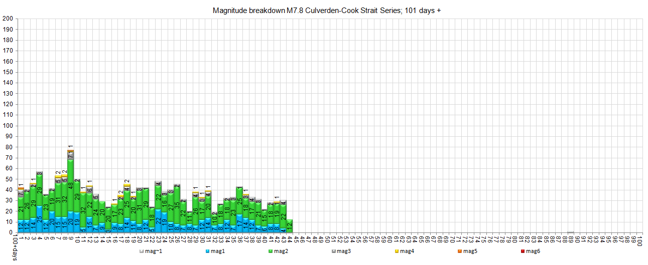
It had been 13 days since I last updated the page, I changed the scale on the 100days+ count graphs as it was getting hard to read the numbers
nzeq2017.blogspot.co.nz...
Summary Whole Series: mag~1= 3 , mag1= 2,312 , mag2= 9,461 , mag3= 2,664 , mag4= 488 , mag5= 56 , mag6= 2 ,mag7= 1 , total= 14,987 , total energy released= 8,349,881 TTNT
Public ID 2017p257850
Intensity strong
Universal Time April 6 2017, 9:42:49
NZ Standard Time Thu, Apr 6 2017, 9:42:49 pm
Depth 11 km
Magnitude 5.0
Location 10 km east of Seddon
Latitude, Longitude -41.69, 174.21
www.geonet.org.nz...
2428 Felt reports
I didn't feel it
GNS Science duty seismologist Caroline Little classified the shake, which was 11km deep, as an aftershock following last November's magnitude-7.8 Kaikoura earthquake.
i.stuff.co.nz...
Interestingly, but probably of no connection
the number of quakes in the Culverden-Cook Strait area took a dive in the 24hrs before this, to just 12 x M2's. Had been hovering at around 29-30 for the last week
already half way through the 6th Apr UTC there have been 24 quakes in the area
It had been 13 days since I last updated the page, I changed the scale on the 100days+ count graphs as it was getting hard to read the numbers
nzeq2017.blogspot.co.nz...
Summary Whole Series: mag~1= 3 , mag1= 2,312 , mag2= 9,461 , mag3= 2,664 , mag4= 488 , mag5= 56 , mag6= 2 ,mag7= 1 , total= 14,987 , total energy released= 8,349,881 TTNT
edit on 04000000959517 by muzzy because: (no reason given)
another one, to the SW this time
Public ID 2017p260291
Intensity strong
Universal Time April 7 2017, 7:23:23
NZ Standard Time Fri, Apr 7 2017, 7:23:23 pm
Depth 10 km
Magnitude 4.6
Location 40 km south-west of Seddon
Latitude, Longitude -41.98, 173.87
www.geonet.org.nz...
strangely USGS are showing them both at the same magnitude 4.5mb
at least they are showing them!
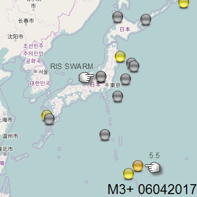
Not sure about this one from JMA-NIED
how could the main networks miss a 5.5???
even if it was converted to mb or Mw its still around a high 4 or 5.0ish
the 0km depth is a bit of a clue that it might be a mistake, it was on the Pacific Plate
NIED are usually pretty reliable
Lat/Long: 23.108, 145.258;
JST: 06/04/2017 20:18:47;
UTC: 06/04/2017 11:18:47;
Depth: 0;
Mag: 5.5 ML;
Location: FAR E OFF OGASAWARA;
Energy Released: 2681.6885 tonnes of TNT;
Source: JMA Status: reviewed
japanquakes.blogspot.co.nz...
Also NW of Tokyo, a small swarm, possibly another case of (RIS) Reservoir Induced Seismicity?
only 3-4km from 2 large hydro dam reservoirs
PREF= MID NIIGATA PREF
NO=46
M~1=26
M1=12
M2=6
M3=3
you can even see this on the animated thumbs possibly only because it is away on its own from the rest of the icons, but you can see the darker base on both the M2 and the M3 images.So that's good, it achieves what I set out to do with the animations.
I actually noticed this before I made the maps, the Pref Name jumped out at me me on the Excel file, I still run the Pref Count table, although I don't publish it, MID NIIGATA PREF pushed E OFF FUKUSHIMA PREF down off its No2 spot where it has been for months behind NORTHERN IBARAKI PREF.
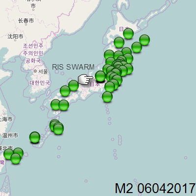
Nothing much in the last 18 months in Mid Niigata Prefecture, I did a 2016 and 2017 timeline graph, the biggest previous was just a 3.7 on 31/10/2016 about 16km to the NW, it just had 16 aftershocks
how could the main networks miss a 5.5???
even if it was converted to mb or Mw its still around a high 4 or 5.0ish
the 0km depth is a bit of a clue that it might be a mistake, it was on the Pacific Plate
NIED are usually pretty reliable
Lat/Long: 23.108, 145.258;
JST: 06/04/2017 20:18:47;
UTC: 06/04/2017 11:18:47;
Depth: 0;
Mag: 5.5 ML;
Location: FAR E OFF OGASAWARA;
Energy Released: 2681.6885 tonnes of TNT;
Source: JMA Status: reviewed
japanquakes.blogspot.co.nz...
Also NW of Tokyo, a small swarm, possibly another case of (RIS) Reservoir Induced Seismicity?
only 3-4km from 2 large hydro dam reservoirs
PREF= MID NIIGATA PREF
NO=46
M~1=26
M1=12
M2=6
M3=3
you can even see this on the animated thumbs possibly only because it is away on its own from the rest of the icons, but you can see the darker base on both the M2 and the M3 images.So that's good, it achieves what I set out to do with the animations.
I actually noticed this before I made the maps, the Pref Name jumped out at me me on the Excel file, I still run the Pref Count table, although I don't publish it, MID NIIGATA PREF pushed E OFF FUKUSHIMA PREF down off its No2 spot where it has been for months behind NORTHERN IBARAKI PREF.
edit on 04000000969617 by muzzy because: (no reason given)
Nothing much in the last 18 months in Mid Niigata Prefecture, I did a 2016 and 2017 timeline graph, the biggest previous was just a 3.7 on 31/10/2016 about 16km to the NW, it just had 16 aftershocks
edit on 04000000969617 by muzzy because: (no reason given)
looks like another earthquake just south of Manila this afternoon.
are we getting ready for the big one, that they have been going on about the last couple or so years? they even held simultaneous earthquake drills at one of the two biggest mall chains a couple weeks ago.
Updated February 14, 2017
www.philstar.com...
MANILA, Philippines (First published 4:10 p.m.) - A 5.6-magnitude earthquake shook Batangas and nearby provinces, seismologists said Saturday afternoon. Philippine Institute of Volcanology and Seismology traced the epicenter of the tremor at 2 kilometers northwest of Mabini, Batangas. The tremor, which occurred at 3:07 p.m in Mabini, Batangas, was felt at various intensities in nearby provinces and even in Metro Manila. It had a depth of 4 kilometers and was tectonic in origin. The quake was felt strongest in Mabini, Batangas, where Intensity VII was reported.
This was followed by a 5.9-magnitude quake south southwest of Tanauan, Batangas, the US Geological Survey reported.
are we getting ready for the big one, that they have been going on about the last couple or so years? they even held simultaneous earthquake drills at one of the two biggest mall chains a couple weeks ago.
Updated February 14, 2017
www.philstar.com...
Phivolcs warns Valley Fault residents MANILA, Philippines - Residents of Metro Manila and nearby provinces should prepare for the “Big One,” a magnitude 7.2 earthquake to be generated by the West Valley Fault, which is ripe for movement. Amid the devastation caused by the magnitude 6.7 earthquake in Surigao, the Philippine Institute of Volcanology and Seismology (Phivolcs) yesterday appealed to residents of Metro Manila and nearby provinces to prepare for a powerful earthquake that could kill thousands. “Everyone must learn from the recent effects of the magnitude 6.7 earthquake in Surigao del Norte. If a similar event happens in a highly urbanized area, the effects can be more devastating,” Phivolcs director Renato Solidum warned. State seismologists have repeatedly warned the public that the West Valley Fault is ripe for movement. Are you in a Metro Manila earthquake zone? The West Valley Fault, Solidum said, moves roughly every 400 years. The last major earthquake generated by this fault was in 1658 or 357 years ago. The 100-kilometer fault traverses parts of Bulacan through Quezon City, Marikina, Makati, Pasig, Taguig and Muntinlupa in Metro Manila; San Pedro, Biñan, Sta. Rosa, Cabuyao and Calamba in Laguna; and Carmona, General Mariano Alvarez and Silang in Cavite. A 2004 study funded by the Japan International Cooperation Agency for Phivolcs and the Metropolitan Manila Development Authority showed that the magnitude 7.2 quake could kill up to 34,000 people and injure 100,000 others due to collapsed buildings.

a reply to: muzzy
the Philippines has started to try to be really proactive when it comes to disasters. especially after the Yolanda typhoon which was in an area that normally doesn't suffer from typhoons. which was made even worse in some areas due to a major earthquake hitting them two weeks before the typhoon. (and they are still working to deal with the fallout from that. a friend just finally had their house rebuilt a couple months ago, after what 4 or 5 years). then after the last big typhoon that hit manila a couple years ago, they started to discuss remedying one of the big damage causers in typhoons. that being non-native trees, that can not withstand the winds and and crash over which did most of the damage (as i saw for myself). most trees like palms and bamboo which are native are much more stable in high winds being able to bend quite well with the wind while not breaking. or "trees" like the banana plant, which being pretty much a grass like structure can bend well, but when they do break they don't cause much damage. and with banana plants, they will easily regrow when destroyed due to them mainly not using seed to reproduce. the stump an other parts will start new growth.
the Philippines has also been proactive in stopping people from living in areas more at risk. such too close to the water and on rivers. as well as too close to active volcanoes. as well as evacuating people from areas at risk from incoming storms and possible volcano eruptions. all this has resulted in far less loss of life in typhoons, and should keep it down for eruptions they suspect may be eminent. another interesting preparedness is "life boats" on some buildings near streams and rivers (i kid you not, i know one building beside a small creek, with about 20 foot high banks, that has a lifeboat on a davits on the roof of the carport). as well as LTO (land transportation office) trucks are normally equipped with small plastic boats and even some amphibious DUK W type trucks, as flash flooding and flooding is common during rainy days and especially typhoons. i know one area where the small "creek" (seriously little more than a trickle of water) overflowed it's deep banks and had a flash flood that was over 1 story deep during typhoon rains years back. and in the last big typhoon that hit Manila rivers rose well over 20 meters in some places.
i have also noticed a lot of earthquake preparedness things being passed around facebook the last couple weeks, as they build up the hype for a possible big one, earthquake they are worried about hitting the Manila area. the official city of Manila (NCR, national capital region) has an area of 619.5 km2, with a population of 12,877,253 (as of 2015, likely far more since i don't know how accurate it is with the millions of squatters). but the reality is the city has expanded into neighboring provinces, and puts the population over 30.4 million (2015). and my honest opinion is that should a big quake happen, there are a lot of tall, narrow buildings. and densely packed poorly built homes (a single fire can render hundreds of families homeless), would be catastrophic, with a very high loss of life, depending on where exactly it hits.
(post by ericblair4891 removed for a serious terms and conditions violation)
a reply to: generik
That sounds progressive and hopefully will save lives.
Just following earthquakes, volcanoes and typhoons over the years I always noted that the Philippines got way more than their share of all three, and as you mentioned sometimes all at the same time.
I wish NZ would get their act together in the same manner, we seem to be getting a lot of natural disasters one after the other here, mainly earthquakes and floods, by the time they clean up one area another area gets whacked, yet we still don't have things like a tsunami warning system or even evacuation plans that are specific enough that you know where to head when the event happens.
Our local Council is wasting time arguing about a big hedge that is encroaching on a road by 1ft rather than working on erosion mitigation or disaster management
edit on 04000000989817 by muzzy because: (no reason given)
And.....
____________________________
Nuclear fission powers the movement of Earth's continents and crust,
blogs.scientificamerican.com...
____________________________
Nuclear fission powers the movement of Earth's continents and crust,
blogs.scientificamerican.com...
new topics
-
President BIDEN's FBI Raided Donald Trump's Florida Home for OBAMA-NORTH KOREA Documents.
Political Conspiracies: 3 hours ago -
Maestro Benedetto
Literature: 5 hours ago -
Is AI Better Than the Hollywood Elite?
Movies: 5 hours ago -
Las Vegas UFO Spotting Teen Traumatized by Demon Creature in Backyard
Aliens and UFOs: 9 hours ago -
2024 Pigeon Forge Rod Run - On the Strip (Video made for you)
Automotive Discussion: 9 hours ago -
Gaza Terrorists Attack US Humanitarian Pier During Construction
Middle East Issues: 10 hours ago -
The functionality of boldening and italics is clunky and no post char limit warning?
ATS Freshman's Forum: 11 hours ago -
Meadows, Giuliani Among 11 Indicted in Arizona in Latest 2020 Election Subversion Case
Mainstream News: 11 hours ago
top topics
-
President BIDEN's FBI Raided Donald Trump's Florida Home for OBAMA-NORTH KOREA Documents.
Political Conspiracies: 3 hours ago, 25 flags -
Krystalnacht on today's most elite Universities?
Social Issues and Civil Unrest: 15 hours ago, 9 flags -
University of Texas Instantly Shuts Down Anti Israel Protests
Education and Media: 17 hours ago, 8 flags -
Weinstein's conviction overturned
Mainstream News: 13 hours ago, 8 flags -
Supreme Court Oral Arguments 4.25.2024 - Are PRESIDENTS IMMUNE From Later Being Prosecuted.
Above Politics: 15 hours ago, 8 flags -
Massachusetts Drag Queen Leads Young Kids in Free Palestine Chant
Social Issues and Civil Unrest: 12 hours ago, 7 flags -
Gaza Terrorists Attack US Humanitarian Pier During Construction
Middle East Issues: 10 hours ago, 7 flags -
Las Vegas UFO Spotting Teen Traumatized by Demon Creature in Backyard
Aliens and UFOs: 9 hours ago, 6 flags -
Meadows, Giuliani Among 11 Indicted in Arizona in Latest 2020 Election Subversion Case
Mainstream News: 11 hours ago, 5 flags -
2024 Pigeon Forge Rod Run - On the Strip (Video made for you)
Automotive Discussion: 9 hours ago, 4 flags
active topics
-
Las Vegas UFO Spotting Teen Traumatized by Demon Creature in Backyard
Aliens and UFOs • 11 • : AwakeNotWoke -
President BIDEN's FBI Raided Donald Trump's Florida Home for OBAMA-NORTH KOREA Documents.
Political Conspiracies • 15 • : AwakeNotWoke -
Is AI Better Than the Hollywood Elite?
Movies • 13 • : Justoneman -
Hate makes for strange bedfellows
US Political Madness • 47 • : 19Bones79 -
-@TH3WH17ERABB17- -Q- ---TIME TO SHOW THE WORLD--- -Part- --44--
Dissecting Disinformation • 689 • : daskakik -
University of Texas Instantly Shuts Down Anti Israel Protests
Education and Media • 265 • : Astrocometus -
Gaza Terrorists Attack US Humanitarian Pier During Construction
Middle East Issues • 27 • : ToneD -
Reason of the Existence
The Gray Area • 21 • : BingoMcGoof -
Supreme Court Oral Arguments 4.25.2024 - Are PRESIDENTS IMMUNE From Later Being Prosecuted.
Above Politics • 85 • : Sookiechacha -
Chris Christie Wishes Death Upon Trump and Ramaswamy
Politicians & People • 24 • : nugget1