It looks like you're using an Ad Blocker.
Please white-list or disable AboveTopSecret.com in your ad-blocking tool.
Thank you.
Some features of ATS will be disabled while you continue to use an ad-blocker.

Quake Watch 2017
page: 16share:
further to: muzzy
you can see what I mean about the animation being lumpy using Google Terrain on this one
24 hr animation 29th March 2017 (the hours are UTC, so 00 is actually lunch time 29th NZST. And the last quake in the animation, the 4.5, hit just before lunch on the 30th NZST)
So the animation was made from 24 screenshots, its only a minor flaw but the roads don't show in some of them (the white line, mainly Hwys41 and 32)
edit on 04000000919117 by muzzy because: (no reason given)
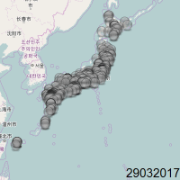
Been experimenting with small animations for the thumbnails on japanearthquakes this morning.
for the last few months I have been doing a map showing quakes above M2, as putting them all on its just a mass of multicoloured orbs, and pretty useless to show whats going on that day.
But the other ~M2 magnitudes are important too, there are always swarms going on in japan.
First I tried just M3+, but the map was a bit sparce, the opposite of showing them all.
then I thought, why not split it into each magnitude, and make an animation.
They are quite small when done, only 40kb, and I could probably reduce that by 30-50% using GIF Optimizer, to save space on the storage at Picasa
See what you think
do you think it is too fast, too slow, or just right?
here is an example
edit on 04000000919117 by muzzy because: (no reason given)
www.fourmilab.ch...
New moon and lunar perigee occur nearly the same day in April and May. April 27 and May 26 give or take a week. Those gravitational forces lining up on the same day is bad news. If we get any solar flares that are earth directed like the one that hit before the Fukushima thing, its even worse. All that energy absorbed by the core causes slight expansion of the crust.
Any stressed fault lines that are ready to slip...
Earth directed flare on March 9, 2011. Two days before Fukushima.
Magnitude 6.5 - Botswana
Location in IRIS Earthquake Browser
- Date-Time: Monday, April 03, 2017 @ 17:40:15 UTC
- Earthquake location: 22.621°S, 25.153°E,
- Earthquake depth: 11.6 km
- Event ID: us10008e3k
Derived from Event Data Source: USGS
Powered by QVSData
Now if it was April !st I would have said April Fool. How often to we get earthquakes this size in Botswana?
a reply to: PuterMan
Not ever that I recall
However there was this 14 hrs prior in that general area
F-E Region: South Africa
Time: 2017-04-03 03:08:52.8 UTC
Magnitude: 5.1 (mb)
Epicenter: 26.75°E 26.93°S
Depth: 10 km
geofon.gfz-potsdam.de...
Not ever that I recall
However there was this 14 hrs prior in that general area
F-E Region: South Africa
Time: 2017-04-03 03:08:52.8 UTC
Magnitude: 5.1 (mb)
Epicenter: 26.75°E 26.93°S
Depth: 10 km
geofon.gfz-potsdam.de...
a reply to: CantStandIt
Yeah it's set at 100 centiseconds which is 1 sec.
Thanks for the feedback
I might do the same for New Zealand as often you can't see the M4's, especially in the Marlborough-Cook Strait series started in Nov 2016, where they get covered by smaller icons
the whole idea of using the thumbnail version of Blogger was so you could see at a glance over the 20 or so days that you can see on the front page which days had something big or interesting (swarms) going on
it wasn't really working showing all the icons as one
edit on 04000000939317 by muzzy because: (no reason given)
a reply to: Miracula2
The different amounts of oil on the dip stick at pre and post start up are because there is oil all over the engine,due to a massive crank and huge pistons throwing oil through a big bit of iron,oil galleries,lower bore,trapped in the rocker gear. I could have said it was just a bad analogy but
The different amounts of oil on the dip stick at pre and post start up are because there is oil all over the engine,due to a massive crank and huge pistons throwing oil through a big bit of iron,oil galleries,lower bore,trapped in the rocker gear. I could have said it was just a bad analogy but
a reply to: muzzy
Hey Muzzy,
Sounding off from South Africa here. I didn't feel the one yesterday morning (03 April 2017) of 03h08 UTC (05h08 local time), but there was a fairly large one 14 hours later, 17h45 UTC (19h45 local) that was quite apparent. continued for around 30-45 seconds before subsiding.
It wasn't bad in my location (curtains swung around a bit, windows rattled a spot, and the tremor was audible), but a friend staying approx. 10km to the East noted that he had picture frames and pans falling off of wall mounts.
I think it might be my geographic location (Living in a small fold-depression, and he's on the cusp of one of the folds).
Hope that adds some useful info!
further to: muzzy
Here is the first one for NZ
I put the M# on each one as well, just for the new readers that might come along and don't know the muzzy colour/magnitude key
on images text is cheap, colour is expensive when it comes to file size, this one was 27.5kb when I made it, and reduced to 20.93KiB when I ran it through ezigif optomizer, a saving of 18.57%.
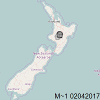
most of the ~1's in NZ are generally around Taupo/Ruapehu area, sometimes near Wairarapa, but generally not in otherparts of the country.
I'll bet it is due to the settings of the SeisComp3 program, rather than that there aren't any elsewhere.
Here is the first one for NZ
I put the M# on each one as well, just for the new readers that might come along and don't know the muzzy colour/magnitude key
on images text is cheap, colour is expensive when it comes to file size, this one was 27.5kb when I made it, and reduced to 20.93KiB when I ran it through ezigif optomizer, a saving of 18.57%.
edit on 04000000939317 by muzzy because: (no reason given)
most of the ~1's in NZ are generally around Taupo/Ruapehu area, sometimes near Wairarapa, but generally not in otherparts of the country.
I'll bet it is due to the settings of the SeisComp3 program, rather than that there aren't any elsewhere.
edit on 04000000939317 by muzzy
because: (no reason given)
further to: muzzy
Ha, there were no recorded M~1 quakes in NZ on the 4th April, I made a 3 image animation but then had to make a blank map to fill in to make it up to 4 images otherwise it was out of synch with the other maps on the home page.
edit: just did a 5 day update for Japan also (raining heavily here, day off), it looks like the sync is lost once 4 or more animations are on the page, or its just random as to how the page loads
I don't really know, first time I've done this
in fact it might be the first time anyone has done this.
edit on 04000000949417 by muzzy because: (no reason given)
a reply to: PuterMan
Aftershocks
2017-04-05 00:55:49 5.1 22.79°S 25.27°E 10 C Botswana
2017-04-03 18:38:20 4.1 23.17°S 24.42°E 19 M Botswana
2017-04-03 18:11:27 4.6 22.71°S 25.12°E 19 M Botswana
geofon.gfz-potsdam.de...
USGS only showing one aftershock
M 5.0 - 141km SSW of Letlhakane, Botswana
2017-04-05 00:55:50 UTC
22.596°S 25.049°E 10.0 km depth
earthquake.usgs.gov...
edit on 04000000939317 by muzzy because: (no reason given)
Khorasan(center) Province, 51 km North-East of Fariman, Iran
5/04/2017 6:09 35.832 60.39 15 ML:6
aftershocks
Khorasan(center) Province, 43-49 km East of Fariman
Time(UTC), Lat., Lon., Depth, Mag.
5/04/2017 6:19, 35.727, 60.385, 15, ML:4.5
5/04/2017 6:24, 35.743, 60.366, 15, ML:4.3
5/04/2017 6:30, 35.732, 60.377, 15, ML:3.6
5/04/2017 6:38, 35.711, 60.394, 15, ML:4.5
5/04/2017 6:43, 35.763, 60.32, 15, ML:4.2
5/04/2017 6:56, 35.746, 60.39, 14, ML:3.5
5/04/2017 7:07, 35.723, 60.384, 15, ML:3.5
5/04/2017 7:32, 35.74, 60.354, 15, ML:3.7
5/04/2017 7:47, 35.707, 60.374, 15, ML:4.9
5/04/2017 7:56, 35.749, 60.366, 15, ML:4.1
www.iiees.ac.ir...
edit on 04000000949417 by muzzy because: (no reason given)
a reply to: muzzy
Some details....
Location in IRIS Earthquake Browser
Derived from Event Data Source: USGS
Powered by QVSData
Further details on my QuakeWatch page
Some details....
Magnitude 6.1 - Northern And Central Iran
Location in IRIS Earthquake Browser
- Date-Time: Wednesday, April 05, 2017 @ 06:09:12 UTC
- Earthquake location: 35.800°N, 60.436°E,
- Earthquake depth: 13.0 km
- Event ID: us10008ei0
Derived from Event Data Source: USGS
Powered by QVSData
Further details on my QuakeWatch page
edit on 5/4/2017 by PuterMan because: To add another link
there was a magnitude 5.5 tectonic earthquake in the Philippines, on Luzon at 8:58 p.m. on Tuesday night, with its epicenter located six kilometers
northeast of Tingloy, Batangas, and was five kilometers deep. so far over 500 aftershocks have been recorded.
i will say i did not feel anything myself either the main earthquake, or any of the aftershocks. although my outside light flickered and flared at about the time of the bigger aftershock. and i am in Quezon City. and i was awake at those times.
newsinfo.inquirer.net...
A 5.4-magnitude earthquake hit Luzon on Tuesday evening, according to the Philippine Institute of Volcanology and Seismology (Phivolcs). An earthquake bulletin issued by the agency said the quake, with an epicenter 7 kilometers northwest of Batangas, was felt in different parts of Luzon at 8:58 p.m. The quake, which was tectonic in origin, was felt at Intensity IV in Makati City and Obando, Bulacan. It was felt at Intensity III in Mandaluyong City, Quezon City, Santa Ana in Manila, General Trias and Dasmariñas in Cavite. Meanwhile, Pasig City and Talisay, Batangas felt the quake at Intensity II. The Phivolcs report said it is not expecting damage although aftershocks may be felt. Minutes before the Phivolcs issued its bulletin, netizens posted on social media that they felt a strong earthquake, which lasted for several seconds.
newsinfo.inquirer.net...
The Philippine Institute of Volcanology and Seismology (Phivolcs) has already recorded more than 500 aftershocks following the magnitude 5.5 earthquake that rocked Batangas province on Tuesday evening, although of this number only less than 10 have been felt. According to Phivolcs research assistant Roschelle Ablan, as of 3 p.m. on Wednesday, 503 aftershocks were recorded, of which 63 were plotted and nine actually felt. The highest of the aftershocks was at magnitude 4.9 at 12:49 a.m. on Wednesday, causing Intensity III shaking in Tagaytay City, Quezon City and Pasig City. The magnitude 5.5 tectonic earthquake struck at 8:58 p.m. on Tuesday night, with its epicenter located six kilometers northeast of Tingloy, Batangas, and was five kilometers deep.
i will say i did not feel anything myself either the main earthquake, or any of the aftershocks. although my outside light flickered and flared at about the time of the bigger aftershock. and i am in Quezon City. and i was awake at those times.
new topics
-
Las Vegas UFO Spotting Teen Traumatized by Demon Creature in Backyard
Aliens and UFOs: 2 hours ago -
2024 Pigeon Forge Rod Run - On the Strip (Video made for you)
Automotive Discussion: 2 hours ago -
Gaza Terrorists Attack US Humanitarian Pier During Construction
Middle East Issues: 3 hours ago -
The functionality of boldening and italics is clunky and no post char limit warning?
ATS Freshman's Forum: 4 hours ago -
Meadows, Giuliani Among 11 Indicted in Arizona in Latest 2020 Election Subversion Case
Mainstream News: 5 hours ago -
Massachusetts Drag Queen Leads Young Kids in Free Palestine Chant
Social Issues and Civil Unrest: 5 hours ago -
Weinstein's conviction overturned
Mainstream News: 6 hours ago -
Supreme Court Oral Arguments 4.25.2024 - Are PRESIDENTS IMMUNE From Later Being Prosecuted.
Above Politics: 8 hours ago -
Krystalnacht on today's most elite Universities?
Social Issues and Civil Unrest: 8 hours ago -
Chris Christie Wishes Death Upon Trump and Ramaswamy
Politicians & People: 8 hours ago
top topics
-
Krystalnacht on today's most elite Universities?
Social Issues and Civil Unrest: 8 hours ago, 9 flags -
Weinstein's conviction overturned
Mainstream News: 6 hours ago, 7 flags -
Supreme Court Oral Arguments 4.25.2024 - Are PRESIDENTS IMMUNE From Later Being Prosecuted.
Above Politics: 8 hours ago, 6 flags -
University of Texas Instantly Shuts Down Anti Israel Protests
Education and Media: 10 hours ago, 6 flags -
Massachusetts Drag Queen Leads Young Kids in Free Palestine Chant
Social Issues and Civil Unrest: 5 hours ago, 4 flags -
Meadows, Giuliani Among 11 Indicted in Arizona in Latest 2020 Election Subversion Case
Mainstream News: 5 hours ago, 4 flags -
Gaza Terrorists Attack US Humanitarian Pier During Construction
Middle East Issues: 3 hours ago, 3 flags -
Chris Christie Wishes Death Upon Trump and Ramaswamy
Politicians & People: 8 hours ago, 2 flags -
Any one suspicious of fever promotions events, major investor Goldman Sachs card only.
The Gray Area: 13 hours ago, 2 flags -
2024 Pigeon Forge Rod Run - On the Strip (Video made for you)
Automotive Discussion: 2 hours ago, 1 flags
active topics
-
Supreme Court Oral Arguments 4.25.2024 - Are PRESIDENTS IMMUNE From Later Being Prosecuted.
Above Politics • 74 • : Threadbarer -
Meadows, Giuliani Among 11 Indicted in Arizona in Latest 2020 Election Subversion Case
Mainstream News • 9 • : Oldcarpy2 -
University student disciplined after saying veganism is wrong and gender fluidity is stupid
Education and Media • 50 • : watchitburn -
VP's Secret Service agent brawls with other agents at Andrews
Mainstream News • 55 • : CarlLaFong -
Cats Used as Live Bait to Train Ferocious Pitbulls in Illegal NYC Dogfighting
Social Issues and Civil Unrest • 23 • : Ravenwatcher -
-@TH3WH17ERABB17- -Q- ---TIME TO SHOW THE WORLD--- -Part- --44--
Dissecting Disinformation • 680 • : 777Vader -
Is there a hole at the North Pole?
ATS Skunk Works • 40 • : Oldcarpy2 -
Fossils in Greece Suggest Human Ancestors Evolved in Europe, Not Africa
Origins and Creationism • 89 • : whereislogic -
University of Texas Instantly Shuts Down Anti Israel Protests
Education and Media • 197 • : NorthOS -
Candidate TRUMP Now Has Crazy Judge JUAN MERCHAN After Him - The Stormy Daniels Hush-Money Case.
Political Conspiracies • 790 • : Oldcarpy2