It looks like you're using an Ad Blocker.
Please white-list or disable AboveTopSecret.com in your ad-blocking tool.
Thank you.
Some features of ATS will be disabled while you continue to use an ad-blocker.

Unknown orange/red glow over Pacific Ocean
page: 13share:
originally posted by: cdesigns

Hahahahahahaha. Oh man, you really don't understand the math and geometry of this AT ALL!
That airplane appears to be on FINAL APPROACH at an altitude of no more than a few thousand feet, IF THAT.....
On top of that, you are looking LATERALLY out of the airplane!!!!
Street signs out the side windows whizz past, while billboards on the horizon out the WINDSHIELD appear to barely move. You are approaching BOTH with the exact SAME velocity, the difference is PERSPECTIVE.
According to you taking ANY photograph is IMPOSSIBLE because the surface of the earth moves at 1675km/h !!!!
originally posted by: SonOfTheLawOfOne
originally posted by: VoidHawk
a reply to: smurfy
Hi smurfy.
As I said earlier, I'll not comment on whether the pics are genuine. My gripe is those stating that they cant be faked, or would be very difficult and require a lot of time, and thinking thats cause to laugh at another member who had doubts about whether the pics are real.
Here's another, took me longer to find the pics than it did to create, imagine what could be done if I spent a couple of hours on it!
While I will applaud your examples of how pictures and EXIF data can be spoofed, it would be presumptuous to say that there is a reason for this guy to fake any of this when all he wants is the island to be named after him.
With that said, are you taking an unbiased approach with all of the circumstances given?
- Skilled photographer with a history of similar photos
- Excellent, very expensive camera (doesn't include lenses)
- A fisheye lens, with knowledge of its application in high exposure shots
- A knowledge of how to use all of these in a plane (demonstrated history)
- A flight over the ring of fire
- The fact that 75% of the Earth's magma output is underwater
- Gasses being released could create either an electric discharge (ionized from the salt?) or an explosion
If I were a betting man... I would say it's a volcano that is about to surface.
I also don't see a reason for this person to have motive to fake this when he has plenty of other outstanding photos of better quality. He isn't claiming something paranormal, just that he saw it and took a picture of it and thought it was worth reporting to others.
It's ok to be skeptical, but there is a point where it becomes a fault.
~Namaste
Hi SonOfTheLawOfOne
I thought I'd made it clear, but I'll repeat it anyway.
As I said earlier, I'll not comment on whether the pics are genuine.
My gripe is those stating that they cant be faked
A member thought the pics (at least one of them) were fake. Other members offered the exif data as evidence for them being genuine, and also suggested the pictures would be too difficult to fake.
Exif data is totally meaningless because its so simple to alter, therefore in no way should be taken as evidence of a picture being genuine.
Also, the pictures were easy to fake, as I proved.
I made it clear I offered no judgment on whether the pics were real!!!
originally posted by: SonOfTheLawOfOne
It's ok to be skeptical, but there is a point where it becomes a fault
When did telling the truth become a fault?
Cdesigns ! might of been better off going down the strip in Vegas at 100 mph !
a reply to: 8675309jenny
I understand what you are saying, everything on that altitude and angle looks slower, but on a 8sec long exposure picture, you will see some of trails on the ground no matter how slow you go or the angle/altitude you are, even me shooting the starts on a tripod from the ground I will see some trails in the stars and they are farther away than what the airplane was from the ground, plus the airplane was traveling a few hundred miles per hour, that will multiply the movement on the ground maybe not on your eyes but it will on a 8sec long exposure picture.
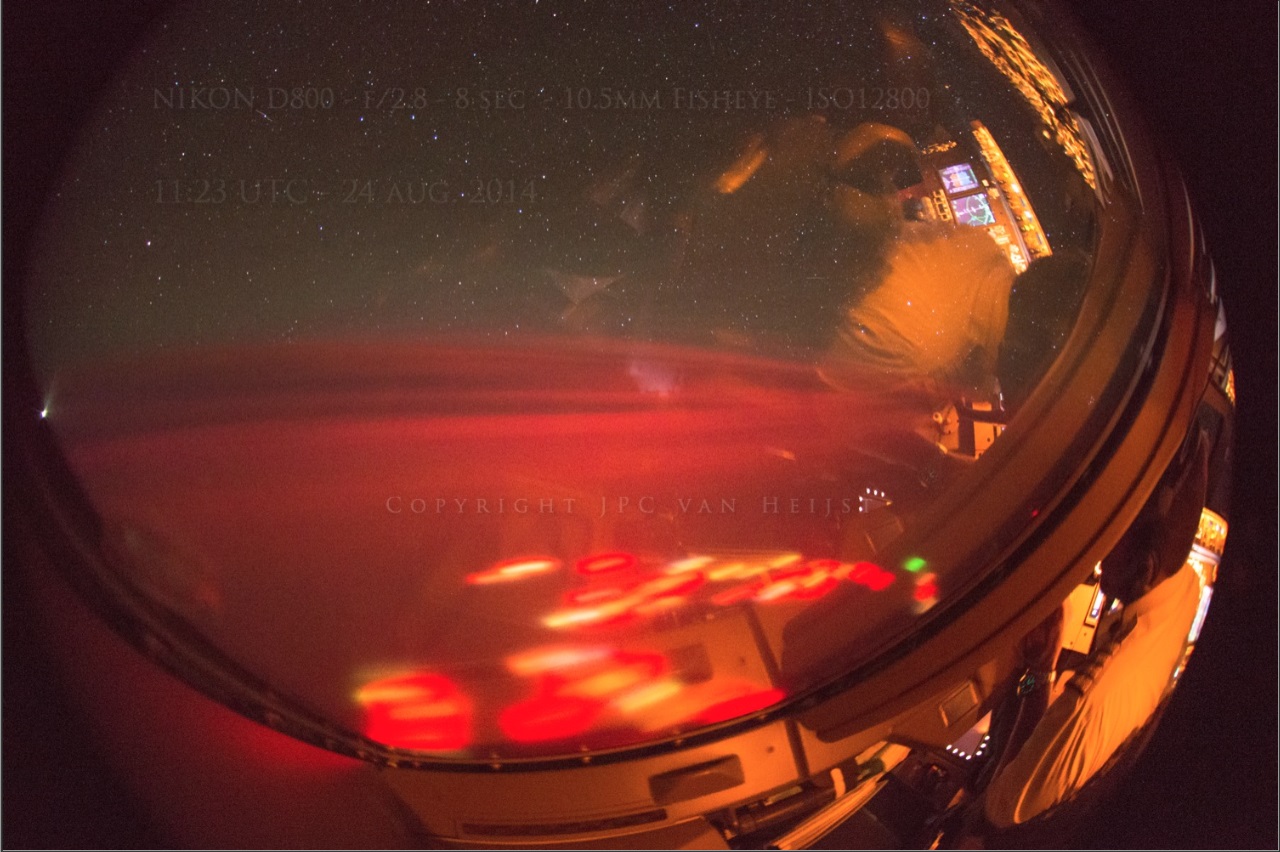
Plus the picture that shows the control panel of the plane on the right corner means the picture was taken on a side/front window.
Is there any video of those lights? I saw a landing video but I haven't seen any video of those lights? he had time to take some perfect pictures on a moving plane but no video of the lights? hmmm
I understand what you are saying, everything on that altitude and angle looks slower, but on a 8sec long exposure picture, you will see some of trails on the ground no matter how slow you go or the angle/altitude you are, even me shooting the starts on a tripod from the ground I will see some trails in the stars and they are farther away than what the airplane was from the ground, plus the airplane was traveling a few hundred miles per hour, that will multiply the movement on the ground maybe not on your eyes but it will on a 8sec long exposure picture.
Plus the picture that shows the control panel of the plane on the right corner means the picture was taken on a side/front window.
Is there any video of those lights? I saw a landing video but I haven't seen any video of those lights? he had time to take some perfect pictures on a moving plane but no video of the lights? hmmm
a reply to: 8675309jenny
The picture was an example, the motion will be less from 34k high but you will see motion blur on the ground on a 8sec. picture. if he was on a steady hot air balloon would be more credible.
The picture was an example, the motion will be less from 34k high but you will see motion blur on the ground on a 8sec. picture. if he was on a steady hot air balloon would be more credible.
originally posted by: lindalinda
Are you really just trying to prove to us that photographs can easily be faked? OK, we get it. Now prove that this photographer faked these photos or move along to curmudgeon another post.
a reply to: VoidHawk
Please read THIS post.
a reply to: cdesigns
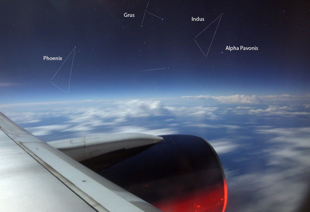
Notice anything about those clouds far in the background? This is 25-second exposure. So why aren't those clouds blurred?
View out the plane window over the Pacific Ocean en route to Hawaii. Above the moonlit clouds “new” southern constellations like Phoenix, Grus and Indus came into view. Details: 16mm , f/2.8, ISO 800 and 25-second exposure. Credit: Bob King - See more at: astrobob.areavoices.com...
Notice anything about those clouds far in the background? This is 25-second exposure. So why aren't those clouds blurred?
originally posted by: smurfy
Hi Void,
Looking back at my post I see there is room for confusion. I was making the point that the pilot had no need to do any photoshop, (in fact I'm still not sure if photoshop can handle the Nikon raw files because they are so big) since they more than likely flew over the new island, Niijima after leaving Hong Kong, and that island is doing everything that is in the picture for free, no need to photoshop at all. If he wanted to fake all he needed do was to say his sighting was somewhere else, like as he did say, somewhere south of Kamchatka. I've no doubt either that just about anything nowadays can be photoshopped, but why spend time on it when there was no need?
Hi smurfy.
Confusion all around on this one
As I said, my gripe wasn't about whether the pics were fake, it was about people using the exif data as if it was evidence they were genuine, and also saying the pics would be very difficult to fake.
Both are untrue.
Exif data is no proof of anything, its only purpose really is for photographers to have a record of the camera and the settings used. Anyone who knows how to edit a file can write into it anything they want.
Could photoshop handle those pictures? Easily! I've loaded 150meg files into it, so long as you have enough memory its not a problem.
The very passage you quote says that the growth rate was highly unusual. Your math depends on a highly accelerated rate being maintained consistently for an extended period of time. And it neglects an important factor, that the growth of a conical structure requires an exponential increase in the amount of material. It's simply not feasible that such a rate could be maintained. You're talking about a rate that would form the Big Island of Hawaii in about 25 years. Nothing of that scale has ever been observed. As the article you quote says, the process is pulsating in nature. There may be sudden small changes, but they'll be punctuated by much longer periods of relative inactivity. I'm confident in saying there has never been a volcanic change in terrain of 10,000 feet in altitude over a period as short as 6 years observed by humans.
originally posted by: SonOfTheLawOfOne
The collapse and growth rates implied by our data are extremely high, compared with measured long-term growth rates of the volcano, demonstrating the pulsating nature of submarine volcanism and highlighting the dynamic nature of the sea floor.
Source
So... let's take 365 days in a year, and divide that by 14 days in their sampling. That gives us roughly 26.
That's how many samplings could be done in a year. Then let's assume that the growth is constant in every sampling of 18.8 meters. That would give us an annual growth of 488.8 meters per year.
You said the last sampling was 2008, so that is 6 years ago.
488.8 meters a year x 6 years = 2,932 meters.
2,932 meters x 3.28 to convert to feet = 9,619 feet.
I would say that's damn close enough to demonstrate that you are wrong.
Even if we don't assume the growth is constant, there is not active monitoring of the volcanic seafloor, and 6 years ago, lava flows from that volcano would not be visible. Give it 6 years to be active, and at a rate equivalent to what has been OBSERVED in other submarine volcanoes, and it is very easy to see how this could be a volcano.
You might want to rethink your hypothesis.
~Namaste
edit on 26-8-2014 by
nataylor because: (no reason given)
originally posted by: theabsolutetruth
a reply to: ElectricUniverse
I suggested TLE or Terrestrial Gamma Ray Flash a few pages back in the thread, IMO it is an obvious possibility and seeing as such things are a recent found phenomena, there is likely much that is not yet known by science about them.
Anti matter explosions, Terrestrial Gamma ray flash map
How would that explain the other red circles in the water and all?
originally posted by: SonOfTheLawOfOne
originally posted by: nataylor
originally posted by: SonOfTheLawOfOne
originally posted by: nataylor
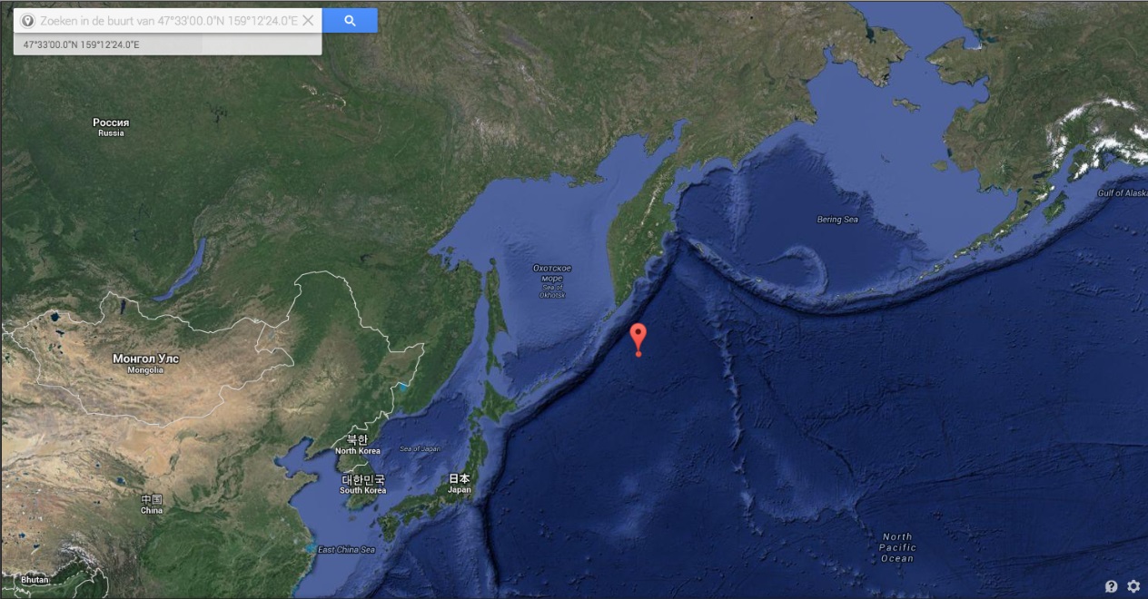
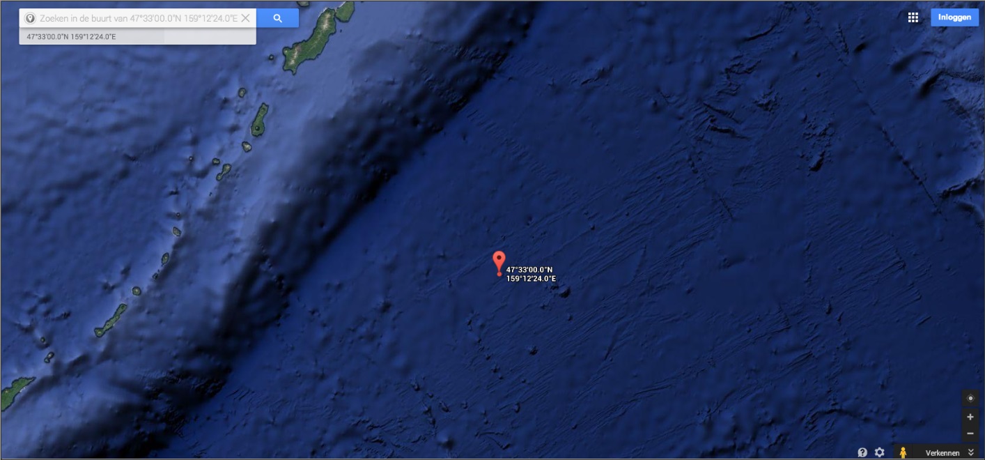
The ocean depth in the area is around 16,000 feet. There's no way you're going to see the light from lava through 3 miles of water.
The lights are from boats. It looks just like a fishing fleet. The only unusual thing is that they're using red lights (although you can see some of them are using the more common whiteish/greenish/yellowish lights you usually see from fishing fleets).
If you look at the mounds that are there in the Google Earth photo based on their approximate location, and consider that it is in an area where lots of volcanos are known to be (both active and inactive), how do you know how high that particular volcano is? That is pure speculation on your part, unless you have a source that can identify the height of that particular volcano. Based on the scale on Google, and it being roughly seven miles wide, it could easily be close enough to the surface and be ejecting lava with enough force to light up the water. Not only that, but with a long exposure, the color of lava rising through the water is going to transition as it heats, expands, cools, bursts, etc., all of which are going to show as different colors in the exposure.
Yeah, that "volcano" (we don't even know if it's a volcano or an extinct cinder cone) peaks at a depth of of about 10,500 feet. Still far too deep for any lava to be visible on the surface.
If we don't know if it's a volcano or an extinct cylinder cone, than how on earth can you know that it peaks at a depth of 10,500 feet?
Please provide a source for this otherwise it is just hearsay on your part. I put the latitude and longitude into several sites that track volcanos and could not find an identification or any data.
You should encourage others to do the research by providing links, otherwise the debate will be against you and not the facts you claim.
~Namaste
Here you go:
maps.ngdc.noaa.gov...
Under Options on the map, turn on bathymetry contours to show the topographic depth contours. The particular cone mentioned before peaks at a depth of 2986 meters (the previous figure I gave was an estimate based on Google Earth).
a reply to: Char-Lee
He mentioned upside down lightning. He was looking out the window and saw the lightning coming from the ocean upwards into the sky. A streak, as in a small comet or meteor is much different than lightning, more so when it is upside down.
He mentioned upside down lightning. He was looking out the window and saw the lightning coming from the ocean upwards into the sky. A streak, as in a small comet or meteor is much different than lightning, more so when it is upside down.
edit on 26-8-2014 by ElectricUniverse because: add comment.
a reply to: Char-Lee
Sprites, elves and a plasma halo are also possible.
www.human-resonance.org...
Sprites, elves and a plasma halo are also possible.
www.human-resonance.org...
Red Sprites and the Pyramid of Fire
by Alex Putney for Human-Resonance.org
September 1, 2011
The latest photographs of high-atmospheric plasma discharges, in various forms called blue jets, sprites and elves, reveal higher quantum states of our atmosphere now manifesting in interesting new ways. The interface of Earth's atmosphere with the vacuum of space is being constantly bombarded by cosmic rays which dissociate water molecules into monatomic gases that become ionized to form luminous plasma, known as auroras.
Auroras are seen in various hues depending on the intensity of the energetic reaction occurring. The lower-intensity plasma formations appear in a range of light greens, whereas high-intensity auroral formations glow a bright pink/red hue.
Security camera surveillance of the skies has captured many examples of the phenomenon of red sprites briefly illuminating the high atmosphere, as observed in these beautiful and haunting images taken in Sant Vilcenç de Castellet, Spain by Oscar van der Velde, seen throughout this page. The brevity of these plasma discharge events prevents thorough documentation of the phenonmenon, but other recent manifestations of red sprites have occurred for over an hour in Xiamen, China.
The flashing eruptions of red sprites commonly occur above intense thunderstorm activity, cooinciding with lightning strikes below the storm cell. The long pink/red vertical plumes rise miles into space, and can be surrounded by a circular plasma halo, refered to by scientists as 'elves'.
The giant vertical plumes often display branched structures that are highly reminiscent of tree branch formations, and for this reason were associated with the sacred life-force of the planet, for all atmospheric lightning and plasma formations cleanse the atmosphere by producing ozone. These tall branching tree-like aerial plasma formations were depicted in several ancient traditions that have not been previously identified.
During two separate flare-ups in Longview, Texas these radiant, arching plumes of plasma appear to have spontaneously ignited at about 6 feet above ground level (above). The colors of the plasma appear to closely resemble those pink/red hues of the high-altitude sprites, which correspond to the known emissions of HHO plasma, formed by the ignition of water vapor as defined by Dr. R. Mills of Blacklight Power.
originally posted by: nataylor
a reply to: smurfy
Except, there's no way a volcano could go from 10,000 feet deep to breaking through the surface in a mater of years (the last major bathymetric survey in the area was in 2008). You don't see 10,000 foot volcanic mountains popping up overnight.
I would guess that everything is not at 10,000ft below the surface of water and for instance Tamu Massif is certainly not, it's very low tip is 6,500ft below the surface, and even so the pacific ocean itself is variable in depth at times..it heaves.
Tamu Massif is the greater part of the Shatsky Rise anyway, and that area corresponds to where the pictures were taken. Also funnily enough, that area is the subject of other research that appears to show that the Shatsky Rise moved considerably laterally in previous pole shifts. I'm looking into that stuff now.
Yes, the depth of the ocean is variable. However, in the area of the sighting, the abyssal plain is roughly at a depth of 5000 meters, and the particular volcanic cone that was being discussed peaks at a depth of 2986 meters. Tamu Massif is about 1,000 miles south of this area.
originally posted by: smurfy
originally posted by: nataylor
a reply to: smurfy
Except, there's no way a volcano could go from 10,000 feet deep to breaking through the surface in a mater of years (the last major bathymetric survey in the area was in 2008). You don't see 10,000 foot volcanic mountains popping up overnight.
I would guess that everything is not at 10,000ft below the surface of water and for instance Tamu Massif is certainly not, it's very low tip is 6,500ft below the surface, and even so the pacific ocean itself is variable in depth at times..it heaves.
Tamu Massif is the greater part of the Shatsky Rise anyway, and that area corresponds to where the pictures were taken. Also funnily enough, that area is the subject of other research that appears to show that the Shatsky Rise moved considerably laterally in previous pole shifts. I'm looking into that stuff now.
edit on 26-8-2014 by nataylor because: (no reason given)
originally posted by: ElectricUniverse
a reply to: Char-Lee
He mentioned upside down lightning. He was looking out the window and saw the lightning coming from the ocean upwards into the sky. A streak, as in a small comet or meteor is much different than lightning, more so when it is upside down.
True and it would have to be a large object to look like that going into the water i would assume.
a reply to: VoidHawk
No offense intended... I agreed with you about the EXIF data... I was just critical of what appeared to be a biased point of view without consideration for the other facts.
To your point, truth is relative.
A wise man once said - "Everything we hear is an opinion, not a fact. Everything we see is a perspective, not the truth."
I agree with your perspective, but the truth is for each of us to find ourselves.
~Namaste
originally posted by: theabsolutetruth
a reply to: ElectricUniverse
I suggested TLE or Terrestrial Gamma Ray Flash a few pages back in the thread, IMO it is an obvious possibility and seeing as such things are a recent found phenomena, there is likely much that is not yet known by science about them.
Anti matter explosions, Terrestrial Gamma ray flash map
Yes, it is probable that if this account is true that it was something similar to what happened in 2004 south of Madagascar.
And they do seem to be recent phenomenon. IMO, the way this person is describing it, it seems that they saw and captured an event in which a section of the Earth's core was interacting with Earth's atmosphere in that area. We should be seeing these events more often if Earth's magnetic field continues to weaken rapidly in most areas, and strengthens in others.
Think of it as a plasma globe, with the earth's mantle and core being the high voltage electrode and the atmosphere being the crystal. I could be wrong of course, but that's what comes to mind.
UPDATE:
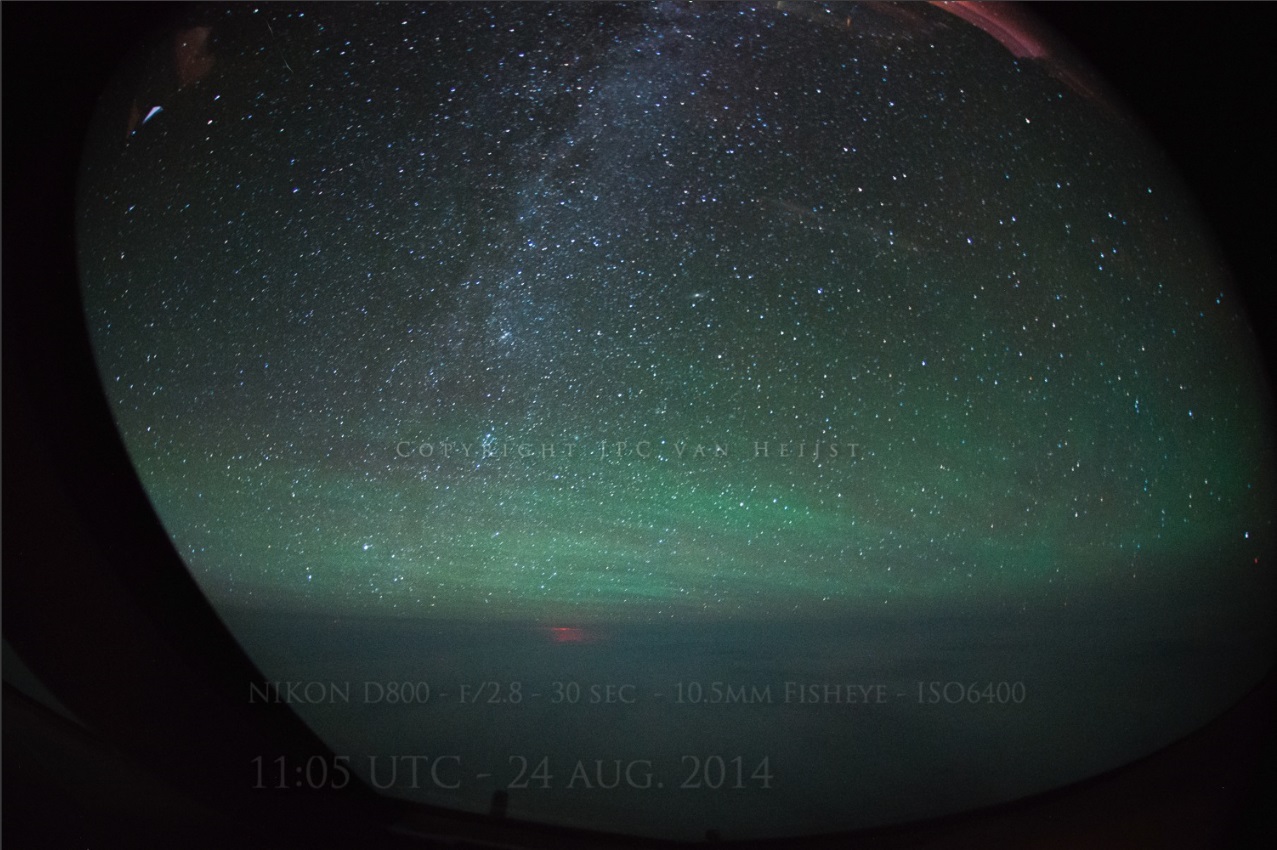
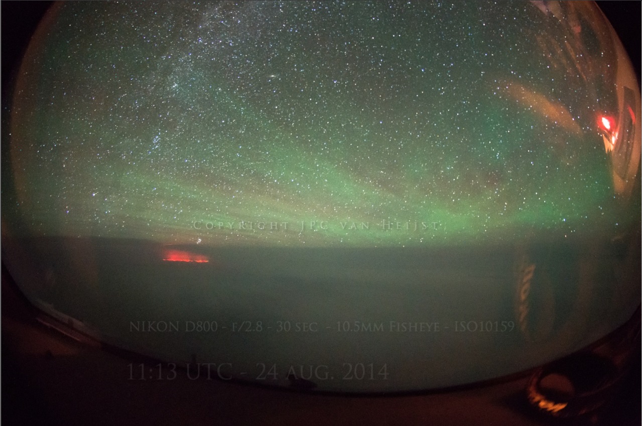
The photos can be viewed in higher resolution on the photographer's website (click)
Added 4 new photos and google-earth map with underwater geography
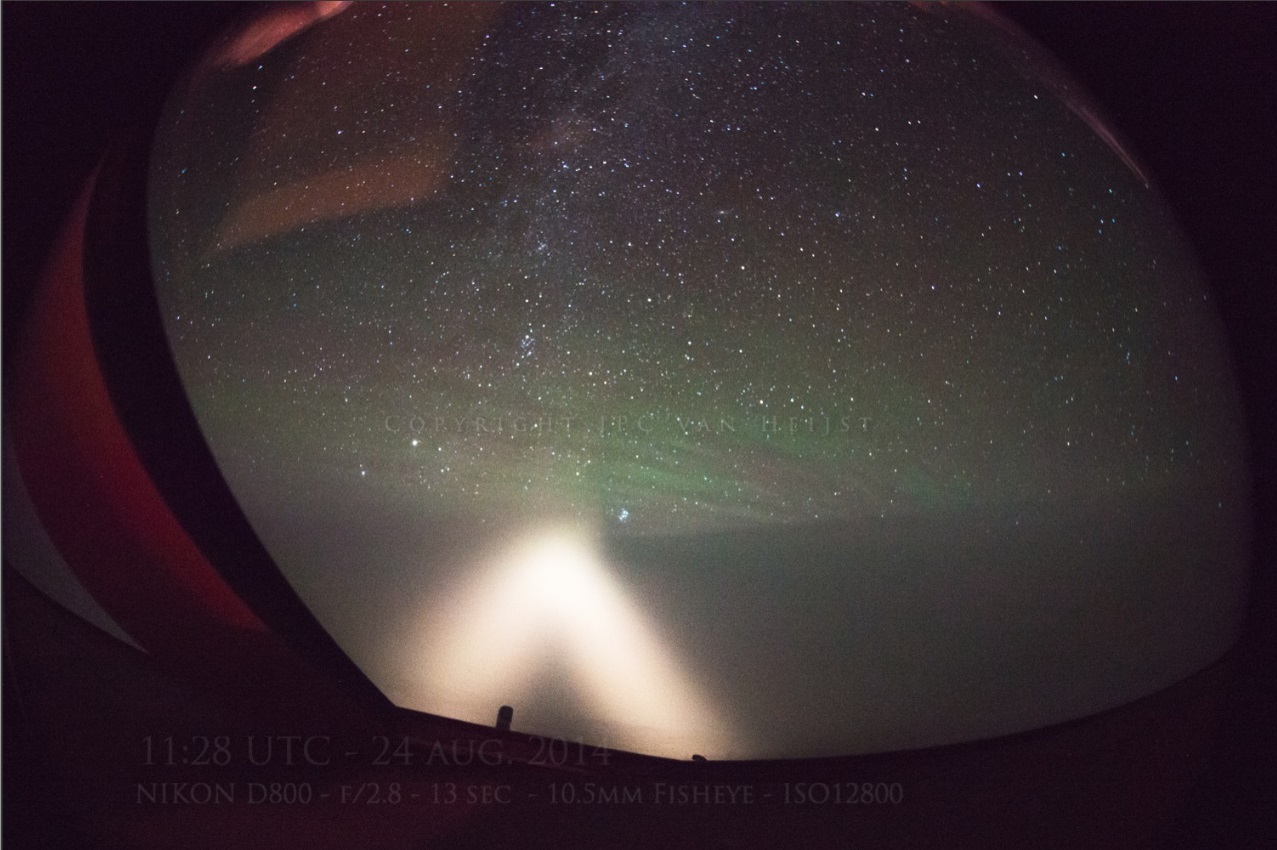
One of the photos shows our landing lights illuminating the sky ahead since we were afraid we might be encountering an ashcloud. We entered a thin layer of clouds 5 minutes after passing the red glow, but no ash was detected or encountered.
The photos can be viewed in higher resolution on the photographer's website (click)
edit on 26-8-2014 by AnonymousWitness because: (no reason given)
new topics
-
Australian PM says the quiet part out loud - "free speech is a threat to democratic dicourse"...?!
New World Order: 42 minutes ago -
Ireland VS Globalists
Social Issues and Civil Unrest: 1 hours ago -
Biden "Happy To Debate Trump"
Mainstream News: 1 hours ago -
RAAF airbase in Roswell, New Mexico is on fire
Aliens and UFOs: 1 hours ago -
What is the white pill?
Philosophy and Metaphysics: 3 hours ago -
Mike Pinder The Moody Blues R.I.P.
Music: 4 hours ago -
Putin, Russia and the Great Architects of the Universe
ATS Skunk Works: 7 hours ago -
A Warning to America: 25 Ways the US is Being Destroyed
New World Order: 11 hours ago
top topics
-
President BIDEN's FBI Raided Donald Trump's Florida Home for OBAMA-NORTH KOREA Documents.
Political Conspiracies: 17 hours ago, 35 flags -
A Warning to America: 25 Ways the US is Being Destroyed
New World Order: 11 hours ago, 20 flags -
Mike Pinder The Moody Blues R.I.P.
Music: 4 hours ago, 7 flags -
What is the white pill?
Philosophy and Metaphysics: 3 hours ago, 5 flags -
Biden "Happy To Debate Trump"
Mainstream News: 1 hours ago, 5 flags -
RAAF airbase in Roswell, New Mexico is on fire
Aliens and UFOs: 1 hours ago, 4 flags -
Australian PM says the quiet part out loud - "free speech is a threat to democratic dicourse"...?!
New World Order: 42 minutes ago, 4 flags -
Putin, Russia and the Great Architects of the Universe
ATS Skunk Works: 7 hours ago, 3 flags -
Ireland VS Globalists
Social Issues and Civil Unrest: 1 hours ago, 2 flags
active topics
-
Biden "Happy To Debate Trump"
Mainstream News • 25 • : LSU2018 -
Supreme Court Oral Arguments 4.25.2024 - Are PRESIDENTS IMMUNE From Later Being Prosecuted.
Above Politics • 96 • : xuenchen -
Ireland VS Globalists
Social Issues and Civil Unrest • 6 • : TimBurr -
-@TH3WH17ERABB17- -Q- ---TIME TO SHOW THE WORLD--- -Part- --44--
Dissecting Disinformation • 695 • : Thoughtful3 -
President BIDEN's FBI Raided Donald Trump's Florida Home for OBAMA-NORTH KOREA Documents.
Political Conspiracies • 32 • : network dude -
Massachusetts Drag Queen Leads Young Kids in Free Palestine Chant
Social Issues and Civil Unrest • 20 • : Oldcarpy2 -
Australian PM says the quiet part out loud - "free speech is a threat to democratic dicourse"...?!
New World Order • 2 • : ColeYounger2 -
Starburst galaxy M82 - Webb Vs Hubble
Space Exploration • 10 • : LSU2018 -
Putin, Russia and the Great Architects of the Universe
ATS Skunk Works • 24 • : Oldcarpy2 -
Gaza Terrorists Attack US Humanitarian Pier During Construction
Middle East Issues • 81 • : KrustyKrab