It looks like you're using an Ad Blocker.
Please white-list or disable AboveTopSecret.com in your ad-blocking tool.
Thank you.
Some features of ATS will be disabled while you continue to use an ad-blocker.

Unknown orange/red glow over Pacific Ocean
page: 14share:
I'm gonna say that I think an alien craft has crashed into the ocean.
This is such an interesting thread! I've been following it for a couple days now. I don't really have anything to add since I don't know what's
going on, but I just wanted to say that I'm enjoying the discussion. Nice find, OP!
a reply to: AnonymousWitness
That is so awesome! Thanks! And thank him for us!
You can ask a mod to include some of your posts in the OP.
That is so awesome! Thanks! And thank him for us!
You can ask a mod to include some of your posts in the OP.
a reply to: Deaf Alien
He is checking here regularly, so he knows .
About editing the OP, I wanted to do that before, then saw the 4 hour limit.. If a mod can do that, that would be cool, thanks! I will have to collect the information, and FAQ, with the answers given and hopefully a mod can add that to the OP.
He is checking here regularly, so he knows .
About editing the OP, I wanted to do that before, then saw the 4 hour limit.. If a mod can do that, that would be cool, thanks! I will have to collect the information, and FAQ, with the answers given and hopefully a mod can add that to the OP.
a reply to: AnonymousWitness
That's awesome that he is checking in regularly.
Just PM one of the mods and they will do it. It has been done many times.
That's awesome that he is checking in regularly.
Just PM one of the mods and they will do it. It has been done many times.
originally posted by: nataylor
The very passage you quote says that the growth rate was highly unusual. Your math depends on a highly accelerated rate being maintained consistently for an extended period of time. And it neglects an important factor, that the growth of a conical structure requires an exponential increase in the amount of material. It's simply not feasible that such a rate could be maintained. You're talking about a rate that would form the Big Island of Hawaii in about 25 years. Nothing of that scale has ever been observed. As the article you quote says, the process is pulsating in nature. There may be sudden small changes, but they'll be punctuated by much longer periods of relative inactivity. I'm confident in saying there has never been a volcanic change in terrain of 10,000 feet in altitude over a period as short as 6 years observed by humans.
originally posted by: SonOfTheLawOfOne
The collapse and growth rates implied by our data are extremely high, compared with measured long-term growth rates of the volcano, demonstrating the pulsating nature of submarine volcanism and highlighting the dynamic nature of the sea floor.
Source
So... let's take 365 days in a year, and divide that by 14 days in their sampling. That gives us roughly 26.
That's how many samplings could be done in a year. Then let's assume that the growth is constant in every sampling of 18.8 meters. That would give us an annual growth of 488.8 meters per year.
You said the last sampling was 2008, so that is 6 years ago.
488.8 meters a year x 6 years = 2,932 meters.
2,932 meters x 3.28 to convert to feet = 9,619 feet.
I would say that's damn close enough to demonstrate that you are wrong.
Even if we don't assume the growth is constant, there is not active monitoring of the volcanic seafloor, and 6 years ago, lava flows from that volcano would not be visible. Give it 6 years to be active, and at a rate equivalent to what has been OBSERVED in other submarine volcanoes, and it is very easy to see how this could be a volcano.
You might want to rethink your hypothesis.
~Namaste
Can you please point out where the paper says the growth rate was highly unusual?
If you are referring to this sentence, you may want to re-read the specific details:
Hydroacoustic T-wave data reveal a 5-day-long swarm of seismic events with unusually high amplitude between the surveys, which directly link the depth changes to explosive activity at the volcano. The collapse and growth rates implied by our data are extremely high, compared with measured long-term growth rates of the volcano, demonstrating the pulsating nature of submarine volcanism and highlighting the dynamic nature of the sea floor.
The only mention of unusual are the strong seismic events in between the surveys, which they correlated to explosive activity in the volcano. They did not say that the activity of the volcano itself was unusual in any way.
They go on to refer to the difference in the long-term growth versus the burst in growth from explosive activity.
My point was that a volcano can grow in size much faster than you claimed. You say it is not feasible, yet the paper I provided to you shows that in 3 weeks, a single volcano can grow by 8.5 million cubic meters of lava and debris. Since grater than 75% of the planet's volcanoes are underwater, I think it's a bit presumptuous of you to say that it is infeasible, considering that almost all observed volcanic data being gathered is from terrestrial volcanoes, which behave completely differently than those in water or under extreme pressure and depth.
You say there may be sudden small changes with longer periods of inactivity? Why not the opposite? Why couldn't a volcano be active for an extended period of time with short periods of inactivity?
Kīlauea has been active for over 40 years. All it would take is for this one spot to be a far more active vent.
Just because we haven't observed a volcano with that kind of growth doesn't mean it isn't possible or feasible. That's a very broad assumption that you would have a hard time proving since the very large majority (more than 40,000) of known volcanoes are underwater.
You may be confident, or it could be mistaken as arrogance, but either way, we will have to agree to disagree.
~Namaste
edit on 26-8-2014 by SonOfTheLawOfOne because: (no reason given)
There are many things that you just do not do when flying an airplane if you do not want to die. Flying into a volcanic ash cloud is one of those
things. I can assure you that ATC, the FAA, and pilots take the discovery/tracking of such clouds very seriously. If he did actually report this
I'm sure there will be a big investigation and if it is found that he hoaxed this in any way, not only would his career be over but he could be
looking at jail time.
I just don't see why he would risk his career over this.
I guess we will just have to wait and see if an investigation is started and what they find.
However, if they find an underwater alien base or something, don't expect to hear a peep about it!!!
I just don't see why he would risk his career over this.
I guess we will just have to wait and see if an investigation is started and what they find.
However, if they find an underwater alien base or something, don't expect to hear a peep about it!!!
originally posted by: nataylor
originally posted by: SonOfTheLawOfOne
originally posted by: nataylor
originally posted by: SonOfTheLawOfOne
originally posted by: nataylor
The ocean depth in the area is around 16,000 feet. There's no way you're going to see the light from lava through 3 miles of water.
The lights are from boats. It looks just like a fishing fleet. The only unusual thing is that they're using red lights (although you can see some of them are using the more common whiteish/greenish/yellowish lights you usually see from fishing fleets).
If you look at the mounds that are there in the Google Earth photo based on their approximate location, and consider that it is in an area where lots of volcanos are known to be (both active and inactive), how do you know how high that particular volcano is? That is pure speculation on your part, unless you have a source that can identify the height of that particular volcano. Based on the scale on Google, and it being roughly seven miles wide, it could easily be close enough to the surface and be ejecting lava with enough force to light up the water. Not only that, but with a long exposure, the color of lava rising through the water is going to transition as it heats, expands, cools, bursts, etc., all of which are going to show as different colors in the exposure.
Yeah, that "volcano" (we don't even know if it's a volcano or an extinct cinder cone) peaks at a depth of of about 10,500 feet. Still far too deep for any lava to be visible on the surface.
If we don't know if it's a volcano or an extinct cylinder cone, than how on earth can you know that it peaks at a depth of 10,500 feet?
Please provide a source for this otherwise it is just hearsay on your part. I put the latitude and longitude into several sites that track volcanos and could not find an identification or any data.
You should encourage others to do the research by providing links, otherwise the debate will be against you and not the facts you claim.
~Namaste
Here you go:
maps.ngdc.noaa.gov...
Under Options on the map, turn on bathymetry contours to show the topographic depth contours. The particular cone mentioned before peaks at a depth of 2986 meters (the previous figure I gave was an estimate based on Google Earth).
Much appreciated.
Also, given that link, there have only been two bathymetric surveys of that specific region near 47N, 160E.
Neither of them surveyed the volcano directly, they were both several miles away from the peak / cone itself.
One was conducted in 1976, so that's almost 50 years for growth if you go by that survey. Here is that survey info:
Survey ID: SI343619
Survey Type: Bathymetry
Platform Name: Silas Bent
Survey Start Year: 1976
Survey End Year: 1976
Source Institution: US Navy Naval Oceanographic Office
Project: LEG 1,2.
Country: USA
Chief Scientist: NAVOCEANO CODE 3432
Date Added: 11/10/1980
Another was done in 1986, so 40 years or growth in that case:
Survey ID: PPTU11WT
Platform Name: Thomas Washington
Survey Year: 1986
Chief Scientist: Lonsdale, Peter and Smith, K.
Instrument: SeaBeam
File Count: 13
Track Length: 11543 km
Total Time: 552 hours
Bathymetry Beams: 4.581622 million
Amplitude Beams: 0 million
Sidescan: 0 million pixels
I checked every option on that map, and I'm not finding the survey from 2008 or anything close to that date.
Basically, the source you provided is showing me that the area hasn't been surveyed for 40-50 years.
I'd be happy to attach a screen shot that shows the routes the scanning vessels took through the area.
If you could please show me how you arrived at the 2008 date? Because if you're claiming that we're discussing "infeasible" growth over a 6 year period, but the scanning period is actually 40-50 years ago, you can probably see how I would arrive at a different conclusion than you are.
40-50 years of unknown growth certainly makes my perspective a bit more.... feasible.
~Namaste
EDIT: I went through the trouble of creating a screen shot and marking off the area in question, the latitude and longitude as indicated by the pilot at the time of the sighting, and the bathymetric survey routes with their respective dates and the legend for correlation.
Am I missing something or did you make an assumption that was inaccurate or incorrect?

files.abovetopsecret.com...
edit on 26-8-2014 by SonOfTheLawOfOne because: added screen shot
edit on 26-8-2014 by SonOfTheLawOfOne because: (no reason
given)
a reply to: Deaf Alien
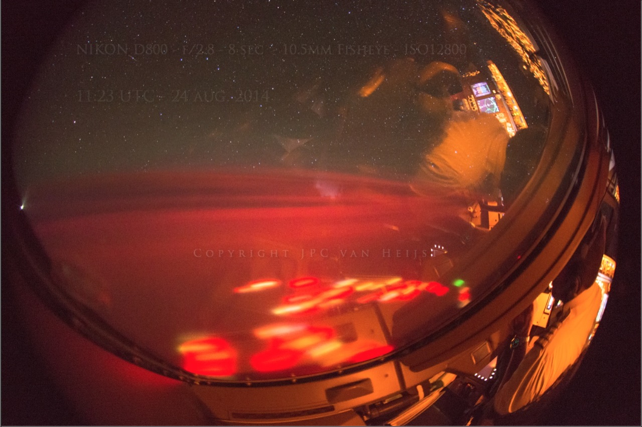
Well all I see in this picture is Startrails from the earth rotation (RED LINE) and ground blur because of foward movement (RED ARROWS)
So you have trails and blur on that picture......all I see is you are proving my point once again. a 8sec picture will show less trail or blur, but it will still show it.
edit on 26-8-2014 by cdesigns because: (no reason given)
edit on 26-8-2014 by cdesigns because: (no reason given)
a reply to: cdesigns
LOL no. I'm talking about clouds FURTHER in the background. And btw that picture is a SIDE VIEW picture.
Anyway please see the new pictures AnonymousWitness posted here:
www.abovetopsecret.com...
One of the pictures from that post:
You can clearly see the trails.
Happy now?
LOL no. I'm talking about clouds FURTHER in the background. And btw that picture is a SIDE VIEW picture.
Anyway please see the new pictures AnonymousWitness posted here:
www.abovetopsecret.com...
One of the pictures from that post:
You can clearly see the trails.
Happy now?
edit on 8/26/2014 by Deaf Alien because: (no reason given)
a reply to: SonOfTheLawOfOne
The 2008 number comes from the bathymetry contours data set (GEBCO_08). www.gebco.net...
It originated in 2008, but the current version is actually from October, 2010. So I was off there.
As it says, the data set was generated by "by combining quality-controlled ship depth soundings with interpolation between sounding points guided by satellite-derived gravity data."
originally posted by: nataylor
a reply to: SonOfTheLawOfOne
The 2008 number comes from the bathymetry contours data set (GEBCO_08). www.gebco.net...
It originated in 2008, but the current version is actually from October, 2010. So I was off there.
As it says, the data set was generated by "by combining quality-controlled ship depth soundings with interpolation between sounding points guided by satellite-derived gravity data."
I checked the option to include the GEBCO_08 data set. It is included in the screen shot.
They use the data from the other vessel scans, combined with other data sets that have an undetermined date.
Just because they compiled and released a map in 2008, does not mean that the data they used to compose it is from any time after 1976 or 1986.
If I included that data set, and all of the options available in that map from NOAA, why would it exclude scans that took place from any other vessels or not display the data set derived from GEBCO? I can see the difference with the GEBCO data in some parts of the map when it is checked and unchecked, but those changes are not shown or reflected in the area in question on the map from NOAA, which is inclusive of the GEBCO data.
Please see the screenshot in my previous post. It includes the following layers, and the bathymetry contours in the "Options" are turned on....
Bathymetry Surveys:
Multibeam Bathymetry Surveys
Single-Beam (Trackline) Bathymetry Surveys
NOS Hydrographic Surveys:
Surveys with BAGs (Bathymetric Attributed Grids)
Surveys with Digital Sounding Data
Surveys without Digital Sounding Data
BAG Color Shaded Relief Imagery
The source you provided for the GEBCO site does not mention anywhere what their sources of data are, what dates they were derived from or how the data was gathered other than the vague quote you mentioned above.
~Namaste
edit on 26-8-2014 by SonOfTheLawOfOne because: (no reason given)
I never thought I'd hear this story again! My brothers good friend that flys military cargo planes between the west coast and hawaii described this
EXACT same experience to me! The only difference was the location and get this....HE SAW IT ON A CLEAR NIGHT! We were at a club here in Vegas and I
was asking him what the strangest thing he ever saw was while flying and he described it like this "I was flying between The west coast and hawaii
doing an over night cargo flight when all of a sudden I see this bright beam of light shoot strait up in the sky from the ocean. As soon as the light
went out and I looked down I couldn't believe my eyes, right where the light came from A MASSIVE BRIGHT UFO THE SIZE OF A CITY WITH BRIGHT COLORED
LIGHTS ALL AROUND IT WAS RISING OUT OF THE WATER!! Mind you I was at cruising altitude and this thing was clearly visible and insanely massive. Then
it just rose up into the sky and disappeared in an instant!" Wow, right? I believed every word he told me because first off he is a close friend and
secondly he was adamant that I not tell the other military guys that we were with because he may lose his flying status if it got around. I could see
the fear in his eyes when he tried to explain to me how massive it was and how it changed his life seeing it. I'm going to send him the pictures of
this thing he won't believe it.
And no that is not seismic activity glowing in four or five different colors from that altitude and that size, if it was that volcano must be bigger than a large city. Plus a bright beam of light is not characteristic of lightning. Lightning branches off and algae doesn't beam light either.
And no that is not seismic activity glowing in four or five different colors from that altitude and that size, if it was that volcano must be bigger than a large city. Plus a bright beam of light is not characteristic of lightning. Lightning branches off and algae doesn't beam light either.
a reply to: SonOfTheLawOfOne
The GEBCO_08 data set is used to generate the topographical contours on the map. You can look at the user guide, which is linked to at the bottom of the GEBCO web page I linked to to see what data sets went into its creation (there's a lot of them, from a lot of different countries). The fact it's checked against gravitational satellite altimetry means any large differences between bathymetry scans conducted over a number of years would stand out like a sore thumb.
The GEBCO_08 data set is used to generate the topographical contours on the map. You can look at the user guide, which is linked to at the bottom of the GEBCO web page I linked to to see what data sets went into its creation (there's a lot of them, from a lot of different countries). The fact it's checked against gravitational satellite altimetry means any large differences between bathymetry scans conducted over a number of years would stand out like a sore thumb.
Have U2U'd an admin, send him an update for the OP, I hope it can be edited in.
originally posted by: Glassbender777
Wow, excellent pics. I wonder if this has anything to do with the Earthquakes. It is very strange. I could see where maybe Earths magnetic field is disrupted during an earthquake creating these lights. Still awesome firsthand account
I have heard of people seeing the Earth's magnetic field be disrupted before a major earthquake, like the ones in Chile and Haiti. The Iceland volcano does tie in well with the California quake, too, now that I think about it.
originally posted by: cdesigns
a reply to: 8675309jenny
I understand what you are saying, everything on that altitude and angle looks slower, but on a 8sec long exposure picture, you will see some of trails on the ground no matter how slow you go or the angle/altitude you are, even me shooting the starts on a tripod from the ground I will see some trails in the stars and they are farther away than what the airplane was from the ground, plus the airplane was traveling a few hundred miles per hour, that will multiply the movement on the ground maybe not on your eyes but it will on a 8sec long exposure picture.
Plus the picture that shows the control panel of the plane on the right corner means the picture was taken on a side/front window.
Is there any video of those lights? I saw a landing video but I haven't seen any video of those lights? he had time to take some perfect pictures on a moving plane but no video of the lights? hmmm
You're saying on the ground with a tripod you can't take an 8sec exposure without startrails?
Canon EOS 5D Mark III camera, using the Canon EF 15mm F/2.8 Fisheye lens @ F/3.5, 30 seconds, ISO 6400.

Check google for milky way images at 30sec exposure times. They are VERY possible with a wide angle lens.
As for video; Can the D800 take videos?
If not, then maybe the only video available would have been cellphone video which would have been absolute garbage in those lighting conditions.
Two things you're not factoring in with these pictures, 1: very obvious forward motion blur when he takes pictures out the SIDE windows of the cockpit,
AND 2:
The 180° fisheye lens focuses light from a much wider area onto the SAME portion of the CCD, so it really really minimizes the motion blur.
If someone were to attempt any of these pictures with even a comparable camera but a standard lens, they would be MUCH worse.
edit on 27-8-2014 by 8675309jenny because: (no reason given)
Just had a new thought.
What if one of those massive trash swirls in the ocean caught fire? The amount of Pacific ocean debris is absolutely massive after Fukushima too.
What if one of those massive trash swirls in the ocean caught fire? The amount of Pacific ocean debris is absolutely massive after Fukushima too.
new topics
-
We need less laws in the UK not more
General Chit Chat: 2 hours ago -
The Baloney aka BS Detection Kit
Social Issues and Civil Unrest: 7 hours ago -
Suspected Iranian agent working for Pentagon while U.S. coordinated defense of Israel
US Political Madness: 7 hours ago -
How does my computer know
Education and Media: 10 hours ago
top topics
-
Suspected Iranian agent working for Pentagon while U.S. coordinated defense of Israel
US Political Madness: 7 hours ago, 13 flags -
USO 10 miles west of caladesi island, Clearwater beach Florida
Aliens and UFOs: 14 hours ago, 9 flags -
The Baloney aka BS Detection Kit
Social Issues and Civil Unrest: 7 hours ago, 6 flags -
How does my computer know
Education and Media: 10 hours ago, 3 flags -
We need less laws in the UK not more
General Chit Chat: 2 hours ago, 2 flags
active topics
-
Suspected Iranian agent working for Pentagon while U.S. coordinated defense of Israel
US Political Madness • 15 • : bluesman023 -
It has begun... Iran begins attack on Israel, launches tons of drones towards the country
World War Three • 646 • : YourFaceAgain -
DWAC Trumps Truth social stock soars .
Mainstream News • 109 • : TinfoilTophat -
Running Through Idiot Protestors Who Block The Road
Rant • 59 • : DBCowboy -
The Baloney aka BS Detection Kit
Social Issues and Civil Unrest • 6 • : nugget1 -
President BIDEN Warned IRAN Not to Attack ISRAEL - Iran Responded with a Military Attack on Israel.
World War Three • 41 • : gortex -
Abortions in first 12 weeks should be legalised in Germany, commission says
Medical Issues & Conspiracies • 14 • : Consvoli -
We need less laws in the UK not more
General Chit Chat • 3 • : dothedew -
Afterlife, unknown, so prepare, or just go into the unknown (bad)!!
ATS Skunk Works • 54 • : Kennyb75 -
-@TH3WH17ERABB17- -Q- ---TIME TO SHOW THE WORLD--- -Part- --44--
Dissecting Disinformation • 478 • : cherokeetroy