It looks like you're using an Ad Blocker.
Please white-list or disable AboveTopSecret.com in your ad-blocking tool.
Thank you.
Some features of ATS will be disabled while you continue to use an ad-blocker.

Severe Weather Outbreaks 2014
page: 8share:
a reply to: Havox
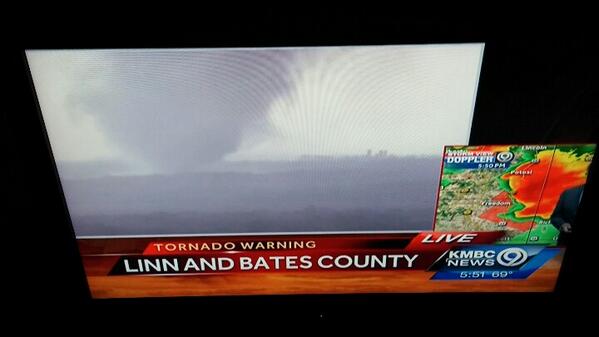
JOPLIN MO WATCH OUT
Tornado Warning
TORNADO WARNING
KSC021-MOC097-272315-
/O.NEW.KSGF.TO.W.0016.140427T2238Z-140427T2315Z/
BULLETIN - EAS ACTIVATION REQUESTED
TORNADO WARNING
NATIONAL WEATHER SERVICE SPRINGFIELD MO
538 PM CDT SUN APR 27 2014
THE NATIONAL WEATHER SERVICE IN SPRINGFIELD HAS ISSUED A
* TORNADO WARNING FOR...
SOUTHEASTERN CHEROKEE COUNTY IN SOUTHEAST KANSAS...
WESTERN JASPER COUNTY IN SOUTHWEST MISSOURI...
* UNTIL 615 PM CDT
* AT 535 PM CDT...A CONFIRMED TORNADO WAS LOCATED NEAR BAXTER
SPRINGS...AND MOVING NORTHEAST AT 45 MPH.
HAZARD...DAMAGING TORNADO. A TORNADO WAS REPORTED NEAR BAXTER
SPRINGS.
SOURCE...WEATHER SPOTTERS CONFIRMED TORNADO.
IMPACT...FLYING DEBRIS WILL BE DANGEROUS TO THOSE CAUGHT WITHOUT
SHELTER. MOBILE HOMES WILL BE DAMAGED OR DESTROYED. DAMAGE
TO ROOFS...WINDOWS AND VEHICLES WILL OCCUR. TREE DAMAGE IS
LIKELY.
* LOCATIONS IMPACTED INCLUDE...
AIRPORT DRIVE...ASBURY...BAXTER SPRINGS...CARL JUNCTION...
CRESTLINE...GALENA...IRON GATES...LAWTON...LOWELL...NEUTRAL...
RIVERTON...SOUTHERN JOPLIN AND WACO.
PRECAUTIONARY/PREPAREDNESS ACTIONS...
TO REPEAT...A TORNADO IS ON THE GROUND. TAKE COVER NOW. MOVE TO AN
INTERIOR ROOM ON THE LOWEST FLOOR OF A STURDY BUILDING. AVOID
WINDOWS. IF IN A MOBILE HOME...A VEHICLE OR OUTDOORS...MOVE TO THE
CLOSEST SUBSTANTIAL SHELTER AND PROTECT YOURSELF FROM FLYING DEBRIS.
&&
LAT...LON 3736 9459 3705 9448 3705 9456 3706 9461
3701 9462 3699 9469 3699 9482 3705 9488
TIME...MOT...LOC 2238Z 225DEG 38KT 3703 9476
TORNADO...OBSERVED
HAIL...
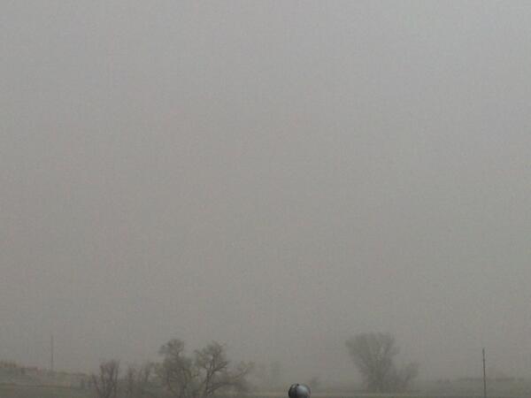
5:42 p.m. CDT Sunday: Dust storm and visbility under one mile reported near Great Bend, Barton County, Kan., reports National Weather Service spotter.
a reply to: MrLimpet
per NWS Kansas
Dust Storm Warning
--------------------------------------------------------------------------------
URGENT - WEATHER MESSAGE
NATIONAL WEATHER SERVICE GOODLAND KS
446 PM MDT SUN APR 27 2014
KSZ001-002-013-014-027-028-280700-
/O.CON.KGLD.DS.W.0002.000000T0000Z-140428T0000Z/
/O.CON.KGLD.HW.W.0006.000000T0000Z-140428T1200Z/
CHEYENNE KS-RAWLINS-SHERMAN-THOMAS-WALLACE-LOGAN-
INCLUDING THE CITIES OF...ST. FRANCIS...ATWOOD...GOODLAND...
COLBY...SHARON SPRINGS...OAKLEY
446 PM MDT SUN APR 27 2014 /546 PM CDT SUN APR 27 2014/
...DUST STORM WARNING REMAINS IN EFFECT UNTIL 6 PM MDT /7 PM CDT/
THIS EVENING...
...HIGH WIND WARNING REMAINS IN EFFECT UNTIL 6 AM MDT /7 AM CDT/
MONDAY...
* PEAK WINDS...NORTHWEST WINDS SUSTAINED AT 35 TO 50 MPH WITH
GUSTS TO 65 MPH.
* TIMING/DURATION...HIGH WINDS HAVE DEVELOPED THIS AFTERNOON AND
WILL GRADUALLY SPREAD EAST THROUGH THE EVENING AND TONIGHT.
* OTHER IMPACTS...AREAS OF BLOWING DUST WILL REDUCE VISIBILITIES
TO NEAR ZERO AT TIMES IN LOCATIONS THAT HAVE NOT RECEIVED
PRECIPITATION. THIS INCLUDES INTERSTATE 70.
PRECAUTIONARY/PREPAREDNESS ACTIONS...
THE KANSAS DEPARTMENT OF HEALTH AND ENVIRONMENT RECOMMENDS THAT
YOU TAKE PREVENTATIVE MEASURES DURING THIS BLOWING DUST EVENT...
SUCH AS STAYING INDOORS OR WEARING PROTECTIVE BREATHING MASKS IF
OUTSIDE. HIGH DUST CONCENTRATIONS CAN CAUSE RESPIRATORY
PROBLEMS...DECREASE LUNG ACTIVITY...AGGRAVATE ASTHMA...AND LEAD
TO POTENTIAL HEART-RELATED PROBLEMS...ESPECIALLY WITH CHILDREN...
ELDERLY...OR THOSE WITH PRE-EXISTING RESPIRATORY CONDITIONS.
A HIGH WIND WARNING MEANS STRONG WINDS ARE EITHER OCCURRING OR
IMMINENT WHICH COULD LEAD TO PROPERTY DAMAGE...REDUCED VISIBILITY
IN BLOWING DUST...AND LOSS OF VEHICLE CONTROL. A HIGH WIND
WARNING IS ISSUED FOR SUSTAINED WIND SPEEDS OF AT LEAST 40 MPH OR
GUSTS OF 58 MPH OR MORE.
A DUST STORM WARNING MEANS VISIBILITY WILL BE REDUCED BELOW ONE
QUARTER MILE IN BLOWING DUST. TRAVELERS ARE URGED TO USE EXTREME
CAUTION AND BE ALERT TO RAPIDLY CHANGING VISIBILITY...ESPECIALLY
NEAR OPEN FIELDS. PERSONS WITH RESPIRATORY PROBLEMS SHOULD STAY
INDOORS UNTIL THE STORM PASSES.
&&
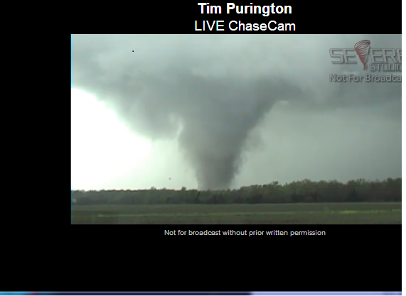
BREAKING: Tornado confirmed at 5:35pm CDT near Baxter Springs KS moving NE 45mph toward Joplin MO. Take cover!
5:41pm Large cone on the ground- Baxter springs, KS
5:41pm Large cone on the ground- Baxter springs, KS
LARGE VIOLENT TORNADO IS ON THE GROUND MOVING NE TOWARD CARL JUNCTION JUST NW OF JOPLIN RESIDENTS SEEK SHELTER ASAP!!
I'm in Illinois right now and the weather is starting to get a little bit dicey... Over the next 3-4 hours it will really get interesting. I just
hope this scary system dies down a little. Stay safe everyone. And I will report from the Chicagoland area with anything that happens.
a reply to: Havox
tonight is shaping up to be the worst outbreak of tornados in years looking at the instability and mucape available the updraft helicity this is very dangerous people please stay tuned will continue to update. I am in a debate to stay in the hotel and update as apposed to chasing.
tonight is shaping up to be the worst outbreak of tornados in years looking at the instability and mucape available the updraft helicity this is very dangerous people please stay tuned will continue to update. I am in a debate to stay in the hotel and update as apposed to chasing.
Living in tornado alley my whole life I must say that tornado systems at nighttime has to be one of the scariest things around. Kinda like swimming
in the ocean at night (you really don't know what's underneath you)...
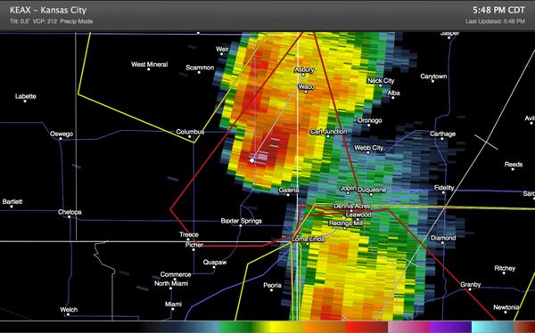
5:54pm – 70mi S of KC at KS/MO border.
Joplin is about to get hit hard as well. Hope everyone there is taking shelter.
Joplin is about to get hit hard as well. Hope everyone there is taking shelter.
a reply to: TechniXcality
I tried to have create a weather watch thread last year similar to the quake watch thread, and nobody really posted in it sadly. I love weather and would've loved to see at least a thread for it get active.
I tried to have create a weather watch thread last year similar to the quake watch thread, and nobody really posted in it sadly. I love weather and would've loved to see at least a thread for it get active.
a reply to: Havox
the problem is people only care about weather when its canceling plans or endangering lives, (not to say that's wrong however its unfortunate) Because we live a closed system and something that happens here effect what happens somewhere else. Also I believe we have made monumental steps in weather forecasting and if anyone is close to predicting the future as it accurately will happen its meteorologist. These subjects are important and frequent ATS I just wish there was a larger medium for the production of factual information and caring people
the problem is people only care about weather when its canceling plans or endangering lives, (not to say that's wrong however its unfortunate) Because we live a closed system and something that happens here effect what happens somewhere else. Also I believe we have made monumental steps in weather forecasting and if anyone is close to predicting the future as it accurately will happen its meteorologist. These subjects are important and frequent ATS I just wish there was a larger medium for the production of factual information and caring people
edit on 27-4-2014 by TechniXcality
because: (no reason given)
LARGE DAMAGING TORNADO ON THE GROUND NEAR HUME MISSOURI! Residents seek shelter NOW!
6pm CDT – Looking west from Joplin, MO at a tornado
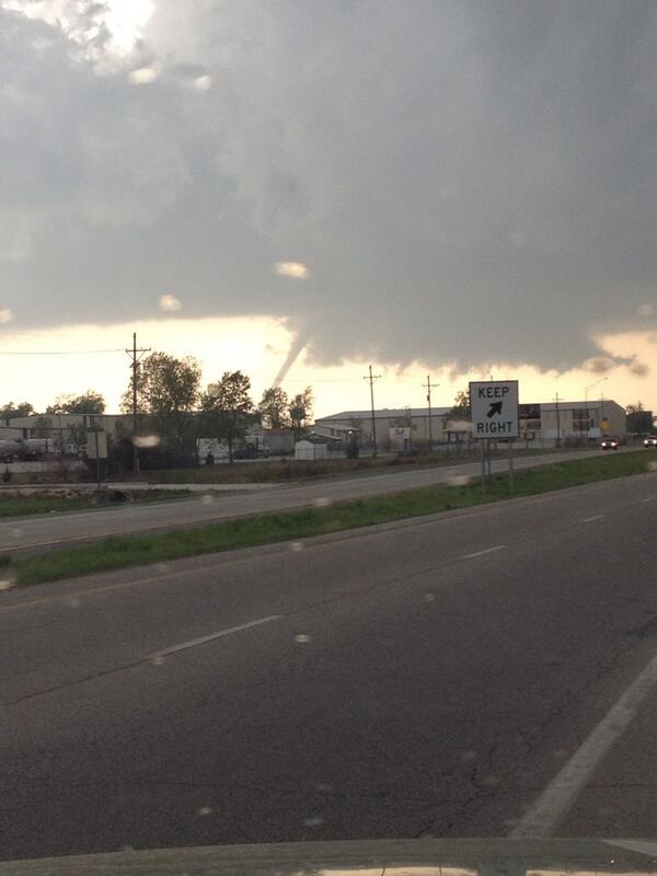
6pm CDT – Looking west from Joplin, MO at a tornado
Great job Everyone on the frequent updates!
- and thanks to the OP for the thread!
Appears it's going to be one hell of a Night;
into the Next few days. - Be alert.
---------
Tis' the season!
- and thanks to the OP for the thread!
Appears it's going to be one hell of a Night;
into the Next few days. - Be alert.
---------
Tis' the season!
TechniX - did you decide to chase tonight or stay put? Seems like things are ramping up.
a reply to: ColorLightShape
thinking im going to stay updating didn't make it far enough into Arkansas I have a few nice pics of wall clouds but I am very concerned about the safety of the larger audience of ATS and believe I can do better service by reporting. Stay safe and please send location and I will give your locations accurate updates thanks
thinking im going to stay updating didn't make it far enough into Arkansas I have a few nice pics of wall clouds but I am very concerned about the safety of the larger audience of ATS and believe I can do better service by reporting. Stay safe and please send location and I will give your locations accurate updates thanks
new topics
-
Big Storms
Fragile Earth: 5 minutes ago -
Where should Trump hold his next rally
2024 Elections: 2 hours ago -
Shocking Number of Voters are Open to Committing Election Fraud
US Political Madness: 3 hours ago -
Gov Kristi Noem Shot and Killed "Less Than Worthless Dog" and a 'Smelly Goat
2024 Elections: 4 hours ago -
Falkville Robot-Man
Aliens and UFOs: 4 hours ago -
James O’Keefe: I have evidence that exposes the CIA, and it’s on camera.
Whistle Blowers and Leaked Documents: 5 hours ago -
Australian PM says the quiet part out loud - "free speech is a threat to democratic dicourse"...?!
New World Order: 6 hours ago -
Ireland VS Globalists
Social Issues and Civil Unrest: 6 hours ago -
Biden "Happy To Debate Trump"
2024 Elections: 7 hours ago -
RAAF airbase in Roswell, New Mexico is on fire
Aliens and UFOs: 7 hours ago
top topics
-
A Warning to America: 25 Ways the US is Being Destroyed
New World Order: 16 hours ago, 21 flags -
Blast from the past: ATS Review Podcast, 2006: With All Three Amigos
Member PODcasts: 9 hours ago, 13 flags -
James O’Keefe: I have evidence that exposes the CIA, and it’s on camera.
Whistle Blowers and Leaked Documents: 5 hours ago, 12 flags -
Australian PM says the quiet part out loud - "free speech is a threat to democratic dicourse"...?!
New World Order: 6 hours ago, 11 flags -
Biden "Happy To Debate Trump"
2024 Elections: 7 hours ago, 10 flags -
Mike Pinder The Moody Blues R.I.P.
Music: 9 hours ago, 8 flags -
What is the white pill?
Philosophy and Metaphysics: 8 hours ago, 6 flags -
Ireland VS Globalists
Social Issues and Civil Unrest: 6 hours ago, 5 flags -
RAAF airbase in Roswell, New Mexico is on fire
Aliens and UFOs: 7 hours ago, 5 flags -
Putin, Russia and the Great Architects of the Universe
ATS Skunk Works: 12 hours ago, 4 flags
active topics
-
University of Texas Instantly Shuts Down Anti Israel Protests
Education and Media • 312 • : marg6043 -
Gov Kristi Noem Shot and Killed "Less Than Worthless Dog" and a 'Smelly Goat
2024 Elections • 30 • : TheMisguidedAngel -
Big Storms
Fragile Earth • 1 • : lilzazz -
Biden "Happy To Debate Trump"
2024 Elections • 46 • : Annee -
President BIDEN's FBI Raided Donald Trump's Florida Home for OBAMA-NORTH KOREA Documents.
Political Conspiracies • 36 • : BingoMcGoof -
ALERT - U.S. President JOE BIDEN Examined and Found NOT OF SOUND MIND.
2024 Elections • 64 • : WeMustCare -
What is the white pill?
Philosophy and Metaphysics • 19 • : TheDiscoKing -
Krystalnacht on today's most elite Universities?
Social Issues and Civil Unrest • 11 • : TheWoker -
Remember These Attacks When President Trump 2.0 Retribution-Justice Commences.
2024 Elections • 59 • : TzarChasm -
Salvador Dali's Moustaches
People • 29 • : GENERAL EYES