It looks like you're using an Ad Blocker.
Please white-list or disable AboveTopSecret.com in your ad-blocking tool.
Thank you.
Some features of ATS will be disabled while you continue to use an ad-blocker.

Severe Weather Outbreaks 2014
page: 9share:
originally posted by: TechniXcality
a reply to: Havox
I am in a debate to stay in the hotel and update as apposed to chasing.
I vote for the hotel and give updates.
Anyone else?
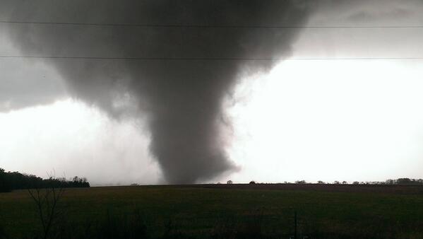
these are all super cell structures please take caution at any point these could turn tornadic the llj is increasing the main impulse is swinging the
mid west way now. Ill report as I can a lot of information to sift through seems the TTU WRF model (TEXAS TECH UNIVERSITY) handled this very well.
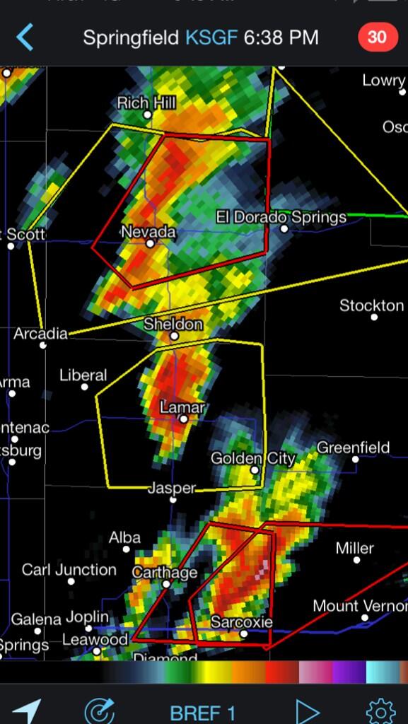
heres the current radar
radar.weather.gov...
radar.weather.gov...
edit on 27-4-2014 by TechniXcality because: (no reason given)
6:15 PM ET: Tornado sirens are sounding in Russelville, AR.
edit on 27-4-2014 by MrLimpet because: (no reason given)
a reply to: MrLimpet
wow look at these destructive storms, evenly separated sparing there own energy single cell(super cells) moving in harmony
radar.weather.gov...
wow look at these destructive storms, evenly separated sparing there own energy single cell(super cells) moving in harmony
radar.weather.gov...
CONFIRMED TORNADO just N of Batesville, MS! Moving NE at 40 mph. Another tornado warning just S of Memphis!
originally posted by: TechniXcality
a reply to: ColorLightShape
thinking im going to stay updating didn't make it far enough into Arkansas I have a few nice pics of wall clouds but I am very concerned about the safety of the larger audience of ATS and believe I can do better service by reporting. Stay safe and please send location and I will give your locations accurate updates thanks
I am on the West Coast -- just concerned about family near Kansas City, Missouri and Andover, KS. I am glad to hear you are staying put and updating from there! I am trying hard to find updates online, but as usual, ATS is the place to get information first!
It's starting to get *that* way here now. Way too dark, way too early. And the air is so still, like a sheet of glass...it's frightening.
Starting to get muggy, and I know tomorrow is going to be a bad day.
I hope all are staying safe. Remember to fill bath tubs with water for drinking or flushing toilets if you think you may be cut of from city services.
Good Luck All!!!
Des
I hope all are staying safe. Remember to fill bath tubs with water for drinking or flushing toilets if you think you may be cut of from city services.
Good Luck All!!!
Des
cautioning southern Missouri. Super cells are developing in the next 3 hours moving in from Arkansas, expect many tornado warnings, in populated
areas.
Stay safe sending love and support
will update as necessary I am focusing on Arkansas and Missouri not that a severe threat doesn't exist elsewhere but it seems Havox has it covered.
www.srh.noaa.gov...
Stay safe sending love and support
will update as necessary I am focusing on Arkansas and Missouri not that a severe threat doesn't exist elsewhere but it seems Havox has it covered.
www.srh.noaa.gov...
edit on 27-4-2014 by TechniXcality because: (no reason given)
edit on 27-4-2014 by TechniXcality
because: (no reason given)
edit on 27-4-2014 by TechniXcality because: (no reason given)
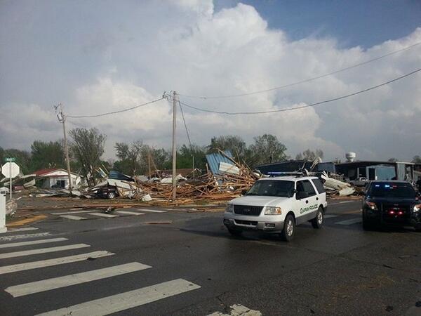
COMFIRMED TORNADO just SW of Nevada, MO!! Take cover now!
Breaking: 2 people dead after #tornado hits Quapaw, OK less than an hour ago. Damage is still being surveyed.
Breaking: 2 people dead after #tornado hits Quapaw, OK less than an hour ago. Damage is still being surveyed.
edit on 27-4-2014 by Havox
because: (no reason given)
a reply to: Havox
Springfield MO be on alert these type of super cells tend to take a eastwardly direction despite storm motion
That's you Wrabbit
radar.weather.gov...
Springfield MO be on alert these type of super cells tend to take a eastwardly direction despite storm motion
That's you Wrabbit
edit on 27-4-2014 by TechniXcality because: (no reason given)
radar.weather.gov...
edit on 27-4-2014 by TechniXcality because: (no reason
given)
a reply to: Wrabbit2000
wrabbit could you step outside and take a pic directly to you wnw? I want to see the anvil and lightning if possible great time at dusk
wrabbit could you step outside and take a pic directly to you wnw? I want to see the anvil and lightning if possible great time at dusk
a reply to: Destinyone
Stay safe Des.
It looks like it's going to be a ruff night.
Stay safe Des.
It looks like it's going to be a ruff night.
edit on 27-4-2014 by MrLimpet because: (no reason given)
Benton,AR checking in.
Muggy, sporadic rain, dark , very still.
I`m keeping an eye on things with Intellicast.com.
Muggy, sporadic rain, dark , very still.
I`m keeping an eye on things with Intellicast.com.
new topics
-
Electrical tricks for saving money
Education and Media: 43 minutes ago -
VP's Secret Service agent brawls with other agents at Andrews
Mainstream News: 2 hours ago -
Sunak spinning the sickness figures
Other Current Events: 2 hours ago -
Nearly 70% Of Americans Want Talks To End War In Ukraine
Political Issues: 2 hours ago -
Late Night with the Devil - a really good unusual modern horror film.
Movies: 4 hours ago -
Cats Used as Live Bait to Train Ferocious Pitbulls in Illegal NYC Dogfighting
Social Issues and Civil Unrest: 6 hours ago -
The Good News According to Jesus - Episode 1
Religion, Faith, And Theology: 7 hours ago -
HORRIBLE !! Russian Soldier Drinking Own Urine To Survive In Battle
World War Three: 10 hours ago
top topics
-
SETI chief says US has no evidence for alien technology. 'And we never have'
Aliens and UFOs: 16 hours ago, 8 flags -
Cats Used as Live Bait to Train Ferocious Pitbulls in Illegal NYC Dogfighting
Social Issues and Civil Unrest: 6 hours ago, 8 flags -
Florida man's trip overseas ends in shock over $143,000 T-Mobile phone bill
Social Issues and Civil Unrest: 13 hours ago, 8 flags -
VP's Secret Service agent brawls with other agents at Andrews
Mainstream News: 2 hours ago, 6 flags -
Former Labour minister Frank Field dies aged 81
People: 15 hours ago, 4 flags -
Bobiverse
Fantasy & Science Fiction: 12 hours ago, 3 flags -
HORRIBLE !! Russian Soldier Drinking Own Urine To Survive In Battle
World War Three: 10 hours ago, 3 flags -
Nearly 70% Of Americans Want Talks To End War In Ukraine
Political Issues: 2 hours ago, 3 flags -
Sunak spinning the sickness figures
Other Current Events: 2 hours ago, 3 flags -
Late Night with the Devil - a really good unusual modern horror film.
Movies: 4 hours ago, 2 flags
active topics
-
Sunak spinning the sickness figures
Other Current Events • 4 • : annonentity -
Cats Used as Live Bait to Train Ferocious Pitbulls in Illegal NYC Dogfighting
Social Issues and Civil Unrest • 12 • : Hakaiju -
HORRIBLE !! Russian Soldier Drinking Own Urine To Survive In Battle
World War Three • 28 • : budzprime69 -
Huge ancient city found in the Amazon.
Ancient & Lost Civilizations • 61 • : Therealbeverage -
The Reality of the Laser
Military Projects • 43 • : 5thHead -
VP's Secret Service agent brawls with other agents at Andrews
Mainstream News • 16 • : matafuchs -
Should Biden Replace Harris With AOC On the 2024 Democrat Ticket?
2024 Elections • 49 • : Therealbeverage -
WF Killer Patents & Secret Science Vol. 1 | Free Energy & Anti-Gravity Cover-Ups
General Conspiracies • 32 • : Arbitrageur -
Is there a hole at the North Pole?
ATS Skunk Works • 38 • : Therealbeverage -
SETI chief says US has no evidence for alien technology. 'And we never have'
Aliens and UFOs • 41 • : TheMisguidedAngel