It looks like you're using an Ad Blocker.
Please white-list or disable AboveTopSecret.com in your ad-blocking tool.
Thank you.
Some features of ATS will be disabled while you continue to use an ad-blocker.

Severe Weather Outbreaks 2014
page: 7share:
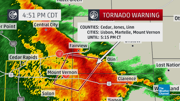
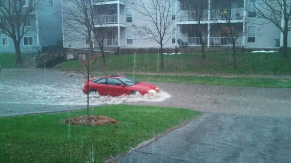
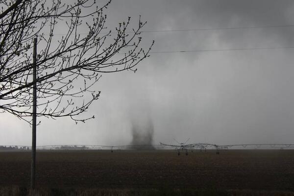
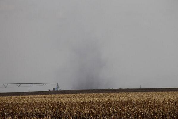
Brief tornado touchdown at 4:41pm CDT near Mt Vernon, IA within this line of storms moving NE:
a reply to: TechniXcality
Night chasing is more dangerous as well, but it sounds like you know what you're doing. Stay safe man and enjoy it, can still get some decent shots in the dark.
Night chasing is more dangerous as well, but it sounds like you know what you're doing. Stay safe man and enjoy it, can still get some decent shots in the dark.
TORNADO ON THE GROUND near MT. VERNON in eastern IOWA moving NE toward MORELY IA… SEEK TORNADO SHELTER NOW!!
They just reported grapefruit size hail in Hugo.
Severe storms approaching Kaufman County, TX area with quarter size hail, 70 MPH winds.
Severe storms approaching Kaufman County, TX area with quarter size hail, 70 MPH winds.
a reply to: Havox
super cells intensifying west central Arkansas on my way there as we speak
radar.weather.gov...
super cells intensifying west central Arkansas on my way there as we speak
radar.weather.gov...
edit on 27-4-2014 by TechniXcality because: (no reason given)
a reply to: TechniXcality
here you go interactive radar out of dallas showing intense rotation there may be a tornado any moment if not already be careful TEXAS
www.wfaa.com...
here you go interactive radar out of dallas showing intense rotation there may be a tornado any moment if not already be careful TEXAS
www.wfaa.com...
originally posted by: TechniXcality
a reply to: ColorLightShape
Wichita Kansas,? is in the clear the dry line has passed ill keep you updated
Thanks very much....! Looking forward to any photos you will be able to post.
tornado warning pope county Arkansas im almost there ill get pic asap
TORNADO WARNING
ARC071-083-115-149-272230-
/O.NEW.KLZK.TO.W.0005.140427T2200Z-140427T2230Z/
BULLETIN - EAS ACTIVATION REQUESTED
TORNADO WARNING
NATIONAL WEATHER SERVICE LITTLE ROCK AR
500 PM CDT SUN APR 27 2014
THE NATIONAL WEATHER SERVICE IN LITTLE ROCK HAS ISSUED A
* TORNADO WARNING FOR...
NORTH CENTRAL YELL COUNTY IN CENTRAL ARKANSAS...
SOUTHERN POPE COUNTY IN CENTRAL ARKANSAS...
NORTHEASTERN LOGAN COUNTY IN WESTERN ARKANSAS...
SOUTHEASTERN JOHNSON COUNTY IN WESTERN ARKANSAS...
* UNTIL 530 PM CDT
* AT 458 PM CDT...NATIONAL WEATHER SERVICE DOPPLER RADAR INDICATED A
SEVERE THUNDERSTORM CAPABLE OF PRODUCING A TORNADO. THIS SEVERE
STORM WAS LOCATED 10 MILES WEST OF MT NEBO SP...OR 12 MILES NORTH
OF DANVILLE. DOPPLER RADAR SHOWED THIS SEVERE STORM MOVING
NORTHEAST AT 45 MPH.
* LOCATIONS IN THE PATH OF THIS DANGEROUS STORM INCLUDE...
RUSSELLVILLE... TARAL... PINEY BAY REC AREA...
MT NEBO SP... LONDON...
LAKE DARDANELLE STATE PARK... LAKE DARDANELLE...
KNOXVILLE... HOLMAN... DOVER...
DARDANELLE LOCK AND DAM...
CABIN CREEK REC AREA... PINEY...
NEW BLAINE... LUTHERVILLE... GUM LOG...
DELAWARE... AUGSBURG...
THIS INCLUDES INTERSTATE 40 BETWEEN MILE MARKERS 64 AND 86.
PRECAUTIONARY/PREPAREDNESS ACTIONS...
TAKE COVER NOW. MOVE TO AN INTERIOR ROOM ON THE LOWEST FLOOR OF A
STURDY BUILDING. AVOID WINDOWS. IF IN A MOBILE HOME...A VEHICLE OR
OUTDOORS...MOVE TO THE CLOSEST SUBSTANTIAL SHELTER AND PROTECT
YOURSELF FROM FLYING DEBRIS.
&&
LAT...LON 3555 9329 3530 9292 3516 9344 3524 9351
TIME...MOT...LOC 2200Z 223DEG 39KT 3523 9342
$$
225
radar.weather.gov...
TORNADO WARNING
ARC071-083-115-149-272230-
/O.NEW.KLZK.TO.W.0005.140427T2200Z-140427T2230Z/
BULLETIN - EAS ACTIVATION REQUESTED
TORNADO WARNING
NATIONAL WEATHER SERVICE LITTLE ROCK AR
500 PM CDT SUN APR 27 2014
THE NATIONAL WEATHER SERVICE IN LITTLE ROCK HAS ISSUED A
* TORNADO WARNING FOR...
NORTH CENTRAL YELL COUNTY IN CENTRAL ARKANSAS...
SOUTHERN POPE COUNTY IN CENTRAL ARKANSAS...
NORTHEASTERN LOGAN COUNTY IN WESTERN ARKANSAS...
SOUTHEASTERN JOHNSON COUNTY IN WESTERN ARKANSAS...
* UNTIL 530 PM CDT
* AT 458 PM CDT...NATIONAL WEATHER SERVICE DOPPLER RADAR INDICATED A
SEVERE THUNDERSTORM CAPABLE OF PRODUCING A TORNADO. THIS SEVERE
STORM WAS LOCATED 10 MILES WEST OF MT NEBO SP...OR 12 MILES NORTH
OF DANVILLE. DOPPLER RADAR SHOWED THIS SEVERE STORM MOVING
NORTHEAST AT 45 MPH.
* LOCATIONS IN THE PATH OF THIS DANGEROUS STORM INCLUDE...
RUSSELLVILLE... TARAL... PINEY BAY REC AREA...
MT NEBO SP... LONDON...
LAKE DARDANELLE STATE PARK... LAKE DARDANELLE...
KNOXVILLE... HOLMAN... DOVER...
DARDANELLE LOCK AND DAM...
CABIN CREEK REC AREA... PINEY...
NEW BLAINE... LUTHERVILLE... GUM LOG...
DELAWARE... AUGSBURG...
THIS INCLUDES INTERSTATE 40 BETWEEN MILE MARKERS 64 AND 86.
PRECAUTIONARY/PREPAREDNESS ACTIONS...
TAKE COVER NOW. MOVE TO AN INTERIOR ROOM ON THE LOWEST FLOOR OF A
STURDY BUILDING. AVOID WINDOWS. IF IN A MOBILE HOME...A VEHICLE OR
OUTDOORS...MOVE TO THE CLOSEST SUBSTANTIAL SHELTER AND PROTECT
YOURSELF FROM FLYING DEBRIS.
&&
LAT...LON 3555 9329 3530 9292 3516 9344 3524 9351
TIME...MOT...LOC 2200Z 223DEG 39KT 3523 9342
$$
225
radar.weather.gov...
edit on 27-4-2014 by TechniXcality because: (no reason given)
originally posted by: Havox
a reply to: TechniXcality
My sister lives in Terrell, hope everyone's safe down there.
I have friends that live outside Terrell. Just tried to call them but no answer.
Terrell is in Kaufman County.
Both super cells have gone tornadic im seeing what looks like a wall cloud in southern pope countie.
a reply to: Havox
storm in kaufman showing very troubling sighns of being tornadic
radar.weather.gov...
storm in kaufman showing very troubling sighns of being tornadic
radar.weather.gov...
new topics
-
Mike Pinder The Moody Blues R.I.P.
Music: 29 minutes ago -
Putin, Russia and the Great Architects of the Universe
ATS Skunk Works: 3 hours ago -
A Warning to America: 25 Ways the US is Being Destroyed
New World Order: 7 hours ago
top topics
-
President BIDEN's FBI Raided Donald Trump's Florida Home for OBAMA-NORTH KOREA Documents.
Political Conspiracies: 13 hours ago, 31 flags -
A Warning to America: 25 Ways the US is Being Destroyed
New World Order: 7 hours ago, 13 flags -
Is AI Better Than the Hollywood Elite?
Movies: 15 hours ago, 4 flags -
Mike Pinder The Moody Blues R.I.P.
Music: 29 minutes ago, 2 flags -
Maestro Benedetto
Literature: 15 hours ago, 1 flags -
Putin, Russia and the Great Architects of the Universe
ATS Skunk Works: 3 hours ago, 1 flags
active topics
-
Putin, Russia and the Great Architects of the Universe
ATS Skunk Works • 12 • : RussianTroll -
Truth Social goes public, be careful not to lose your money
Mainstream News • 132 • : matafuchs -
New whistleblower Jason Sands speaks on Twitter Spaces last night.
Aliens and UFOs • 67 • : Ophiuchus1 -
Gaza Terrorists Attack US Humanitarian Pier During Construction
Middle East Issues • 57 • : ToneD -
Mike Pinder The Moody Blues R.I.P.
Music • 1 • : RussianTroll -
Mood Music Part VI
Music • 3106 • : TheWoker -
University of Texas Instantly Shuts Down Anti Israel Protests
Education and Media • 275 • : Vermilion -
President BIDEN's FBI Raided Donald Trump's Florida Home for OBAMA-NORTH KOREA Documents.
Political Conspiracies • 22 • : 320MPH -
A Warning to America: 25 Ways the US is Being Destroyed
New World Order • 19 • : Cvastar -
Alternate Electors vs Fake Electors - What is the Difference.
2024 Elections • 118 • : Threadbarer