It looks like you're using an Ad Blocker.
Please white-list or disable AboveTopSecret.com in your ad-blocking tool.
Thank you.
Some features of ATS will be disabled while you continue to use an ad-blocker.

Severe Weather Outbreaks 2014
page: 4share:
a reply to: TechniXcality
The dryline seems to still be stalled out in NW texas, most models are putting it through OKC around 10am tomorrow, I'm hoping that actually happens, but I'm starting to worry more about Tulsa and eastnortheast oklahoma. I have a feeling the bullseye might shift back west some from the original AR bullseye.
We currently have some storms just to the east and north of us, with more expected to fire near sunrise. We have the memorial marathon in the city tomorrow morning, here's hoping nothing severe breaks out! Storms out here can pack a brutal punch, even when they aren't tornadic.
a reply to: gluetrap
Yes there has been chatter about a further west initiation. However looking at the nam hi res it shows the most explosive storms over the mid west im waiting for the hhhr rapid refresh model to get into range I haven't looked at the tx tech model or tut wfr. But that certainly is something im going to look at im not near a computer right now but once I am ill report back I hope you are safe tomorrow
heres a link to the WRF model and simulated reflectivity shows initiation further west but quickly moving east these are however super cell thunderstorms be care full
www.atmo.ttu.edu...
edit on 27-4-2014 by TechniXcality because: (no reason
given)
originally posted by: liejunkie01
I'm starting to get pretty nervous.
We are having our son by c section on monday.
I hope it dies down and misses us. It is a 40 minute drive to the hospital monday morning at 5:30.
I'm scared, lj01 needs a hug and someone to tell me it will be ok.
Not in the area, in Australia in fact, but I wanted to wish you, specifically all the best! It's my due date today, so I know all the nerves associated! I hope you get to your caesarean safely, and congratulations in advance! I am sure all will work out to be fine
a reply to: liejunkie01
If you can, get a hotel near the hospital....just to take the stress and worry off and avoid the possibility of danger.
If you can, get a hotel near the hospital....just to take the stress and worry off and avoid the possibility of danger.
Looks as if the Dallas and OK City are out of the danger zone. East Texas & Arkansas under the biggest threat.
Stay safe everyone.

link
Stay safe everyone.
People from eastern Texas to central Iowa should pay close attention to Sunday's weather as storms develop and strengthen during the afternoon with damaging winds, large hail and vigorous tornadoes all possible.
The worst of the storms will develop on Sunday afternoon and into the evening hours with the greatest risk of tornadoes centered around the state of Arkansas.
Some tornadoes that develop in this area could be long-lived, tracking on the ground for many miles before the storm weakens and the twister lifts off the ground.
An added danger will accompany the storms as they continue into Sunday night with the cover of darkness making it difficult to see a storm as it approaches.
link
Thank you everybody for the well wishes.
I got to sleep in until 9 this morning for the last time in a long time.
I have to get up at 3:30 am and have the woman to the hospital.
To technixcality I live in southern Illinois.
In 2005 a tornado struck and flipped my mothers mobile home upside down onto her neighbors home with my sister in it. I personally missed it by about 3 minutes. We were the the first one's on the scene to call for assistance. My sister was ok but two of my mom's neighbors died.
It was a mess and it changed my outlook on tornadoes forever.
a reply to: liejunkie01
Illinois is not out of the danger zone however tornados are expected to a lesser extent than areas further south and west. I promise you will be fine, pay attention to the weather warnings in your area. and best of luck to you and your baby. one good thing in terms of severe threat I woke this morning to rumbles of thunder and rain. Now the atmosphere may become over worked and and loose some instability at least we can hope. However models continue to show a very serious tornado outbreak starting today and into Monday. Be safe guy and gals im gonna chase me some storms
Illinois is not out of the danger zone however tornados are expected to a lesser extent than areas further south and west. I promise you will be fine, pay attention to the weather warnings in your area. and best of luck to you and your baby. one good thing in terms of severe threat I woke this morning to rumbles of thunder and rain. Now the atmosphere may become over worked and and loose some instability at least we can hope. However models continue to show a very serious tornado outbreak starting today and into Monday. Be safe guy and gals im gonna chase me some storms
a reply to: MrLimpet
ill be driving northern Arkansas-south east Missouri. But once again there is some intense convection happening in these areas right now that the models didn't handle to well. This convection may limit this afternoons severe potential. Stay tuned this an ever changing situation
tornado watch posted for western Missouri until 7pm this evening. A tornado watch means conditions are favorable for tornado development not that a tornado has formed or is imminent. Per NWS
Tornado Watch
TORNADO WATCH OUTLINE UPDATE FOR WT 95
NWS STORM PREDICTION CENTER NORMAN OK
1125 AM CDT SUN APR 27 2014
TORNADO WATCH 95 IS IN EFFECT UNTIL 700 PM CDT FOR THE
FOLLOWING LOCATIONS
MOC001-003-009-011-013-015-021-025-029-033-037-039-041-043-047-
049-053-057-059-061-063-075-077-079-081-083-085-089-095-097-101-
107-109-115-117-119-121-129-141-145-147-159-165-167-171-175-177-
185-195-197-209-211-213-217-225-227-280000-
/O.NEW.KWNS.TO.A.0095.140427T1625Z-140428T0000Z/
MO
. MISSOURI COUNTIES INCLUDED ARE
ADAIR ANDREW BARRY
BARTON BATES BENTON
BUCHANAN CALDWELL CAMDEN
CARROLL CASS CEDAR
CHARITON CHRISTIAN CLAY
CLINTON COOPER DADE
DALLAS DAVIESS DEKALB
GENTRY GREENE GRUNDY
HARRISON HENRY HICKORY
HOWARD JACKSON JASPER
JOHNSON LAFAYETTE LAWRENCE
LINN LIVINGSTON MACON
MCDONALD MERCER MORGAN
NEWTON NODAWAY PETTIS
PLATTE POLK PUTNAM
RANDOLPH RAY SALINE
SCHUYLER ST. CLAIR STONE
SULLIVAN TANEY VERNON
WEBSTER WORTH
$$
ATTN...WFO...DMX...EAX...SGF...
edit on 27-4-2014 by TechniXcality because: (no reason given)
a reply to: liejunkie01
here is a national animated mosaic. You can click on your region to see the radar and convection and how close in proximity to you. it looks like you have some cloud cover and convection heading your way out of Missouri, this a good thing as these morning thunderstorms will work to stabilize and use up the instability present in the atmosphere.
radar.weather.gov...
edit on 27-4-2014 by TechniXcality because: (no reason given)
Checking in from the heart of Mo. Starting up now, been out battening down the hatches all morning. Never enough time to do everything but have water
drawn and what you can do done. Just taking a little break and will check back later if I can, thunder rolling in. We are 45 miles North of
Springfield.
Doppler saying coming in at 50 miles per hour, quarter size hail.
Shutting down the comp for a bit.
Living in a modular home is spooky.
Doppler saying coming in at 50 miles per hour, quarter size hail.
Shutting down the comp for a bit.
Living in a modular home is spooky.
Conditions felt bad when we went out to do our grocery shopping this morning, but now that the storms have rolled through, things don't feel as
chancy.
Hopefully, the clouds don't burn off and let the sun go to work. If that happens, we could be in trouble again, but it's still a little early in the year for that.
Hopefully, the clouds don't burn off and let the sun go to work. If that happens, we could be in trouble again, but it's still a little early in the year for that.
a reply to: antar
be safe antar. looks like you have a severe thunderstorm to the south of Springfield moving north east, you are under a tornado watch therefore conditions are favorable for tornado development. correction thunderstorm has been downgraded. regardless be careful
Severe Weather Statement
SEVERE WEATHER STATEMENT
NATIONAL WEATHER SERVICE SPRINGFIELD MO
1252 PM CDT SUN APR 27 2014
MOC043-271802-
/O.CAN.KSGF.SV.W.0079.000000T0000Z-140427T1815Z/
CHRISTIAN MO-
1252 PM CDT SUN APR 27 2014
...THE SEVERE THUNDERSTORM WARNING FOR EASTERN CHRISTIAN COUNTY IS
CANCELLED...
THE STORM WHICH PROMPTED THE WARNING HAS WEAKENED BELOW SEVERE
LIMITS...AND NO LONGER POSES AN IMMEDIATE THREAT TO LIFE OR PROPERTY.
A TORNADO WATCH REMAINS IN EFFECT UNTIL 700 PM CDT SUNDAY EVENING FOR
SOUTHEAST KANSAS AND SOUTHWESTERN MISSOURI.
LAT...LON 3708 9307 3709 9290 3681 9291 3682 9314
TIME...MOT...LOC 1752Z 202DEG 41KT 3698 9297
To give a local report...The morning has been muggy and miserable with humidity and dark overcast. We just started getting rain in the area of
Southwest Missouri that I'm in (near Springfield) and the first thunder of the day. Thunder is coming a couple per minute with some periods of long
rumbling.
I'd note the air feels real energetic...but that is hard to describe.
I'd note the air feels real energetic...but that is hard to describe.
edit on 27-4-2014 by Wrabbit2000 because: (no reason given)
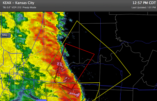
a reply to: Wrabbit2000
tornado warning north of Springfield
Tornado Warning
TORNADO WARNING
MOC033-107-177-271815-
/O.NEW.KEAX.TO.W.0007.140427T1751Z-140427T1815Z/
BULLETIN - EAS ACTIVATION REQUESTED
TORNADO WARNING
NATIONAL WEATHER SERVICE KANSAS CITY/PLEASANT HILL MO
1251 PM CDT SUN APR 27 2014
THE NATIONAL WEATHER SERVICE IN PLEASANT HILL HAS ISSUED A
* TORNADO WARNING FOR...
SOUTHWESTERN CARROLL COUNTY IN NORTH CENTRAL MISSOURI...
WESTERN LAFAYETTE COUNTY IN WEST CENTRAL MISSOURI...
SOUTHEASTERN RAY COUNTY IN WEST CENTRAL MISSOURI...
* UNTIL 115 PM CDT
* AT 1248 PM CDT...A SEVERE THUNDERSTORM CAPABLE OF PRODUCING A
TORNADO WAS LOCATED NEAR ODESSA...AND MOVING NORTH AT 45 MPH.
HAZARD...TORNADO AND GOLF BALL SIZE HAIL.
SOURCE...RADAR INDICATED ROTATION.
IMPACT...FLYING DEBRIS WILL BE DANGEROUS TO THOSE CAUGHT WITHOUT
SHELTER. MOBILE HOMES WILL BE DAMAGED OR DESTROYED. DAMAGE
TO ROOFS...WINDOWS AND VEHICLES WILL OCCUR. TREE DAMAGE IS
LIKELY.
* LOCATIONS IMPACTED INCLUDE...
LEXINGTON...RICHMOND...MAYVIEW...WELLINGTON...HENRIETTA...HARDIN...
NORBORNE...CAMDEN AND DOVER.
THIS WILL IMPACT
I-70 BETWEEN MILE MARKERS 33 AND 45.
PRECAUTIONARY/PREPAREDNESS ACTIONS...
TAKE COVER NOW. MOVE TO AN INTERIOR ROOM ON THE LOWEST FLOOR OF A
STURDY BUILDING. AVOID WINDOWS. IF IN A MOBILE HOME...A VEHICLE OR
OUTDOORS...MOVE TO THE CLOSEST SUBSTANTIAL SHELTER AND PROTECT
YOURSELF FROM FLYING DEBRIS.
&&
LAT...LON 3941 9394 3930 9356 3894 9386 3902 9409
TIME...MOT...LOC 1751Z 198DEG 41KT 3903 9394
TORNADO...RADAR INDICATED
HAIL...1.75IN
$$
AEP
TORNADO WARNING for SW Carroll, W Lafayette, SE Ray Counties, MO just northeast of KC until 1:15 pm CDT!
I'm southwest indiana, right by the illinois border in Princeton, Indiana.
We live in a trailer home.
The ONLY thing open 24/7 is the laundromat across the street. everything else here closes around 9 to 10pm and the closest place during the day is a 4 minute walk away.
Laundromat it is. we'll just go in the bathroom as the mat itself has 6 rows of free standing washers. and huge picture windows.
trailer was all we could find in an emergency move situation. plus i had no idea we were part of tornado alley now else i'd never have moved, excellent job at the time or not. i think there is no safe place in the states anymore between hurricanes on the coasts, quakes out west, yellowstone for half the usa, and nados for us middle/east areas. sigh.
no we have no car. not like we can go anywhere. i spent my last 5 bucks on milk and bread the other day. I suppose if the wind kicks up to where el trailer starts to rock a little more than normal, we'll high tail it across the street. i have our bcertificates, id's and my debit card set, we'll have on steel toed shoes and my hard hats from my old job on our heads.
edit on 14pmSun, 27 Apr 2014 13:14:14 -0500Sun, 27 Apr 2014 13:14:14
-0500pm1833 by sarra1833 because: (no reason given)
a reply to: TechniXcality
Thank you for the updates.
We just got our first batch of heavy rain about 15 minutes ago.
It looks like the next one moving in after a while has a torcon 8, yikes.
Thank you for the updates.
We just got our first batch of heavy rain about 15 minutes ago.
It looks like the next one moving in after a while has a torcon 8, yikes.
a reply to: liejunkie01
your welcome, I promise yours and your baby's safety, and will continue to update on this developing severe weather out break I love you ats!
your welcome, I promise yours and your baby's safety, and will continue to update on this developing severe weather out break I love you ats!
new topics
-
BIDEN Admin Begins Planning For January 2025 Transition to a New President - Today is 4.26.2024.
2024 Elections: 4 hours ago -
Big Storms
Fragile Earth: 5 hours ago -
Where should Trump hold his next rally
2024 Elections: 8 hours ago -
Shocking Number of Voters are Open to Committing Election Fraud
US Political Madness: 9 hours ago -
Gov Kristi Noem Shot and Killed "Less Than Worthless Dog" and a 'Smelly Goat
2024 Elections: 10 hours ago -
Falkville Robot-Man
Aliens and UFOs: 10 hours ago -
James O’Keefe: I have evidence that exposes the CIA, and it’s on camera.
Whistle Blowers and Leaked Documents: 11 hours ago -
Australian PM says the quiet part out loud - "free speech is a threat to democratic dicourse"...?!
New World Order: 11 hours ago
top topics
-
James O’Keefe: I have evidence that exposes the CIA, and it’s on camera.
Whistle Blowers and Leaked Documents: 11 hours ago, 17 flags -
Australian PM says the quiet part out loud - "free speech is a threat to democratic dicourse"...?!
New World Order: 11 hours ago, 15 flags -
Blast from the past: ATS Review Podcast, 2006: With All Three Amigos
Member PODcasts: 15 hours ago, 14 flags -
Biden "Happy To Debate Trump"
2024 Elections: 12 hours ago, 13 flags -
Ireland VS Globalists
Social Issues and Civil Unrest: 12 hours ago, 11 flags -
Mike Pinder The Moody Blues R.I.P.
Music: 15 hours ago, 9 flags -
BIDEN Admin Begins Planning For January 2025 Transition to a New President - Today is 4.26.2024.
2024 Elections: 4 hours ago, 8 flags -
Big Storms
Fragile Earth: 5 hours ago, 7 flags -
What is the white pill?
Philosophy and Metaphysics: 14 hours ago, 6 flags -
Shocking Number of Voters are Open to Committing Election Fraud
US Political Madness: 9 hours ago, 6 flags
active topics
-
Falkville Robot-Man
Aliens and UFOs • 10 • : billxam1 -
Gov Kristi Noem Shot and Killed "Less Than Worthless Dog" and a 'Smelly Goat
2024 Elections • 64 • : cherokeetroy -
What is the white pill?
Philosophy and Metaphysics • 23 • : TheDiscoKing -
BIDEN Admin Begins Planning For January 2025 Transition to a New President - Today is 4.26.2024.
2024 Elections • 21 • : worldstarcountry -
University of Texas Instantly Shuts Down Anti Israel Protests
Education and Media • 317 • : CriticalStinker -
Ditching physical money
History • 23 • : worldstarcountry -
Australian PM says the quiet part out loud - "free speech is a threat to democratic dicourse"...?!
New World Order • 9 • : ScarletDarkness -
-@TH3WH17ERABB17- -Q- ---TIME TO SHOW THE WORLD--- -Part- --44--
Dissecting Disinformation • 704 • : 777Vader -
Mood Music Part VI
Music • 3113 • : MRTrismegistus -
One Flame Throwing Robot Dog for Christmas Please!
Weaponry • 12 • : worldstarcountry