It looks like you're using an Ad Blocker.
Please white-list or disable AboveTopSecret.com in your ad-blocking tool.
Thank you.
Some features of ATS will be disabled while you continue to use an ad-blocker.

Severe Weather Outbreaks 2014
page: 21share:
a reply to: TechniXcality
LOL...I'm Scottish but born in NE TN...
spent most me adult life in Los Angeles.
I have always spoke the accent I am around since I've been
on the planet. I do not try to do it automatically comes
out & authentically...as I have had many Scots ask if I were
from Glasgow...asked farm mate where he was from & it
was Glasgow. It just happens naturally & I have no clue it's
going on that is how natural it is...& is the same with other accents.
Funny you picked up on it & I am probably close to saying
I sometimes do not pat attention & the what should be "my"
becomes "me" dead give away! Plus closest friend from Scotland
but our accents are different he's from the south & luckily for me
accent is north & my last name is famous Scot from the north...
Great catch dude...shows you've been around.
And again thanks for being so attentive on the thread!
Cheers
Ektar
Just in: Mansfield, OH airport gusted to 61mph at 9:09p EDT. Tornado warning til 9:45; storms moving NNE 45mph.
Just in: Monday's tornado in Richland and Pearl, MS was at least an EF3. NWS survey to continue tomorrow. At least 1 person died.
ALERT 8:33p CT: #Tornado warning for Pensacola FL til 9p; radar shows 100+ mph winds aloft. Take cover!
Tornado Warning for Okaloosa County in FL until 9:00 PM CDT

Tornado Warning for Okaloosa County in FL until 9:00 PM CDT
a reply to: Ektar
No I love history culture ect, Im Irish and Sicilian and American Indian ive been all over the world, and appreciate people not for there political assignment or institutionalized establishment, but I love them for humanity the humanity we all share, the fact we all look up at the same moon and stars and ultimately just want a safe and happy family. On that note Florida is experiencing several tornados here's the details Per NWS
Tornado Warning
TORNADO WARNING
FLC091-300200-
/O.NEW.KMOB.TO.W.0022.140430T0134Z-140430T0200Z/
BULLETIN - EAS ACTIVATION REQUESTED
TORNADO WARNING
NATIONAL WEATHER SERVICE MOBILE AL
ISSUED BY NATIONAL WEATHER SERVICE NEW ORLEANS LA
834 PM CDT TUE APR 29 2014
THE NATIONAL WEATHER SERVICE IN MOBILE HAS ISSUED A
* TORNADO WARNING FOR...
OKALOOSA COUNTY IN NORTHWEST FLORIDA...
* UNTIL 900 PM CDT
* AT 833 PM CDT...NATIONAL WEATHER SERVICE METEOROLOGISTS DETECTED A
SEVERE THUNDERSTORM CAPABLE OF PRODUCING A TORNADO NEAR DORCAS...OR
7 MILES NORTHEAST OF CRESTVIEW...MOVING NORTHEAST AT 15 MPH.
PRECAUTIONARY/PREPAREDNESS ACTIONS...
THE SAFEST PLACE TO BE DURING A TORNADO IS IN A BASEMENT. GET UNDER A
WORKBENCH OR OTHER PIECE OF STURDY FURNITURE. IF NO BASEMENT IS
AVAILABLE...SEEK SHELTER ON THE LOWEST FLOOR OF THE BUILDING IN AN
INTERIOR HALLWAY OR ROOM SUCH AS A CLOSET. USE BLANKETS OR PILLOWS TO
COVER YOUR BODY AND ALWAYS STAY AWAY FROM WINDOWS.
IF IN MOBILE HOMES OR VEHICLES...EVACUATE THEM AND GET INSIDE A
SUBSTANTIAL SHELTER. IF NO SHELTER IS AVAILABLE...LIE FLAT IN THE
NEAREST DITCH OR OTHER LOW SPOT AND COVER YOUR HEAD WITH YOUR HANDS.
PLEASE FOLLOW OUR OFFICE ON BOTH FACEBOOK AND TWITTER FOR MORE
INFORMATION ON SEVERE WEATHER AND TO RELAY WEATHER REPORTS AND
PHOTOS.
&&
LAT...LON 3075 8647 3087 8656 3099 8642 3099 8638
3082 8639
TIME...MOT...LOC 0135Z 222DEG 13KT 3083 8648
$$
Tornado Warning
TORNADO WARNING
FLC033-113-300200-
/O.NEW.KMOB.TO.W.0021.140430T0126Z-140430T0200Z/
BULLETIN - EAS ACTIVATION REQUESTED
TORNADO WARNING
NATIONAL WEATHER SERVICE MOBILE AL
ISSUED BY NATIONAL WEATHER SERVICE NEW ORLEANS LA
826 PM CDT TUE APR 29 2014
THE NATIONAL WEATHER SERVICE IN MOBILE HAS ISSUED A
* TORNADO WARNING FOR...
ESCAMBIA COUNTY IN NORTHWEST FLORIDA...
THIS INCLUDES THE CITY OF PENSACOLA...
SANTA ROSA COUNTY IN NORTHWEST FLORIDA...
THIS INCLUDES THE CITY OF NAVARRE...
* UNTIL 900 PM CDT
* AT 824 PM CDT...NATIONAL WEATHER SERVICE METEOROLOGISTS DETECTED A
SEVERE THUNDERSTORM CAPABLE OF PRODUCING A TORNADO NEAR WEST
PENSACOLA...OR NEAR PENSACOLA...MOVING EAST AT 20 MPH.
PRECAUTIONARY/PREPAREDNESS ACTIONS...
THE SAFEST PLACE TO BE DURING A TORNADO IS IN A BASEMENT. GET UNDER A
WORKBENCH OR OTHER PIECE OF STURDY FURNITURE. IF NO BASEMENT IS
AVAILABLE...SEEK SHELTER ON THE LOWEST FLOOR OF THE BUILDING IN AN
INTERIOR HALLWAY OR ROOM SUCH AS A CLOSET. USE BLANKETS OR PILLOWS TO
COVER YOUR BODY AND ALWAYS STAY AWAY FROM WINDOWS.
IF IN MOBILE HOMES OR VEHICLES...EVACUATE THEM AND GET INSIDE A
SUBSTANTIAL SHELTER. IF NO SHELTER IS AVAILABLE...LIE FLAT IN THE
NEAREST DITCH OR OTHER LOW SPOT AND COVER YOUR HEAD WITH YOUR HANDS.
PLEASE FOLLOW OUR OFFICE ON BOTH FACEBOOK AND TWITTER FOR MORE
INFORMATION ON SEVERE WEATHER AND TO RELAY WEATHER REPORTS AND
PHOTOS.
&&
LAT...LON 3051 8734 3054 8718 3049 8715 3040 8720
3037 8714 3046 8695 3050 8703 3054 8701
3045 8706 3044 8710 3055 8713 3060 8681
3038 8681 3036 8721 3038 8718 3040 8720
3038 8726 3034 8726 3034 8732
TIME...MOT...LOC 0126Z 258DEG 18KT 3042 8725
edit on 29-4-2014 by TechniXcality because: (no reason given)
a reply to: TechniXcality
Thank you! A warning is NOT good & I hope Florida
is safe! Yes we share the same views!
Have you guys made a proposal yet for a regular
post? Probably too busy lately... Thanks MrLimpet
I did not mean to leave you out!
Cheers
Ektar
Thank you! A warning is NOT good & I hope Florida
is safe! Yes we share the same views!
Have you guys made a proposal yet for a regular
post? Probably too busy lately... Thanks MrLimpet
I did not mean to leave you out!
Cheers
Ektar
Just got home from work, and the first thing is to check this thread! Glad to see everyone is updating it! You guys are the best.
a reply to: ColorLightShape
what would you think about a meteorology forum. for friends and family of ats?
what would you think about a meteorology forum. for friends and family of ats?
a reply to: TechniXcality
Yes, I am all for that. I think it would be a really unique forum here. Interesting, informative and at times life saving.
Yes, I am all for that. I think it would be a really unique forum here. Interesting, informative and at times life saving.
Does anyone know exactly how may tornadoes have touched down in the last couple of days? How unusual is this event?
a reply to: ColorLightShape
this event dose not rate high to previous analogs trying to find you some data from noaa
here you go
www.ncdc.noaa.gov...
and heres a song
this event dose not rate high to previous analogs trying to find you some data from noaa
here you go
www.ncdc.noaa.gov...
and heres a song
edit on 29-4-2014 by TechniXcality because: (no reason given)
a reply to: ColorLightShape
I don't believe that the number has been confirmed yet, as they are still surveying damage to see if there were multiple tornadoes in different areas etc. but I believe we've seen somewhere around 15-20. Possibly more. It's not that unusual, but it's the first major outbreak of the year. We've usually seen more tornadoes at this point in the year.
I don't believe that the number has been confirmed yet, as they are still surveying damage to see if there were multiple tornadoes in different areas etc. but I believe we've seen somewhere around 15-20. Possibly more. It's not that unusual, but it's the first major outbreak of the year. We've usually seen more tornadoes at this point in the year.
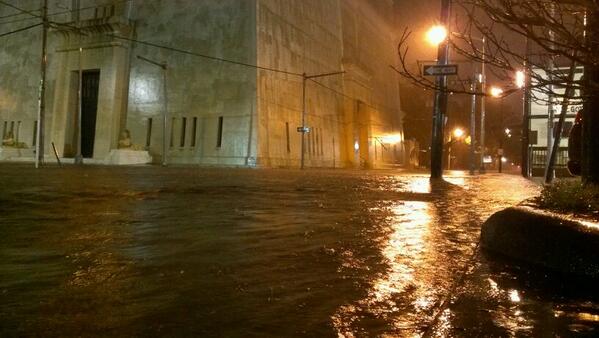
BREAKING 9:45p CT: Flash flood EMERGENCY in Pensacola, FL. Water entering homes; 5.24" rain just fell in 45 min
a reply to: TechniXcality
A meteorology forum falls into the Fragile Earth forum I think. Everything posted is a sub-forum so to speak and has a shelf life.
The weather guys/gals here in Ohio and the various weather related websites initially got me all spun up that this storm was going to be a major one here in Ohio.
But it pretty much fizzled out before everyones eyes.
All the indicators were there...and then nothing. They really haven't been that good at predicting the weather here for years and have been blindsided a lot recently. Especially this past winter.
Still, even though the front has passed without anything happening much, it doesn't mean that it won't as there is a string of storms following right behind it.
a reply to: TDawgRex
TdawgRex they give estimations because they have to. You fall into a paradox most of the time the models can predict and simulate conditions based on previous analogs, but sometimes they fail to see something that has changed in real time and cant calculate to accuracy, now we are getting closer every day. So as a meteorologist or model interpreter/ weather mathematician your job is to save lives, so you cant paint the most likely and or ( absolute) certainty of severe weather the models predict. If you do your wrong and someone has died, on the other hand you may over predict (and have people preparing for nothing) you do the math
No this dose not fall into fragile earth.
This falls under life safety, and requires understanding of earth and it's meteorological occurrence and possible consequences. A forum with trusted forecasters storm chasers and meteorologist is not a logistic nightmare in fact its very easy and could help those of us who don't have internet and or have loved ones your worried about,( the applications go much further).
edit on 29-4-2014 by TechniXcality because: (no reason given)
a reply to: ColorLightShape
We already have a weather forum. Fragile Earth or even Chit-Chat. Weather is constantly changing everywhere. What's effecting you in Cali at the moment will not be affecting me for a few days...if ever.
Hurricane Katrina didn't even affect me weather wise other than some rain, but Hurricane Sandy did. (And I'm sure that many folks in New Orleans thought...better them than us again)
The weather has a finite shelf life.
As for saving lives, and I don't mean to sound cold, but it is, if some one is posting during a tornado warning or something like that and not at a minimum listening to a radio or checking the local weather, they don't have their priorities straight.
a reply to: TDawgRex
I understand there are different interpretations on how a internet web board should be run, I also understand there are those who believe they can and should enforce there beliefs based on "experience"
But I never knew there was a shelf life, regarding life safety. I also cant believe you would say a seeker ( more so a desperate person in danger). priorities are not straight based on there medium of information.
Im not sure your assertions are logical, but thank you for your genuine concern for ats and it's users
Amarillo Tx, im almost sure this is one of the latest freeze of the season
Freeze Warning
URGENT - WEATHER MESSAGE
NATIONAL WEATHER SERVICE AMARILLO TX
900 PM CDT TUE APR 29 2014
OKZ001-TXZ001-002-006-007-011-012-017-301200-
/O.CAN.KAMA.DS.W.0005.000000T0000Z-140430T0300Z/
/O.CAN.KAMA.HW.W.0008.000000T0000Z-140430T0300Z/
/O.CON.KAMA.FZ.W.0002.140430T0600Z-140430T1500Z/
CIMARRON-DALLAM-SHERMAN-HARTLEY-MOORE-OLDHAM-POTTER-RANDALL-
INCLUDING THE CITIES OF...BOISE CITY...KEYES...DALHART...
STRATFORD...HARTLEY...CHANNING...DUMAS...VEGA...AMARILLO...CANYON
900 PM CDT TUE APR 29 2014
...FREEZE WARNING REMAINS IN EFFECT FROM 1 AM TO 10 AM CDT
WEDNESDAY...
...DUST STORM WARNING IS CANCELLED...
...HIGH WIND WARNING IS CANCELLED...
THE NATIONAL WEATHER SERVICE IN AMARILLO HAS CANCELLED THE DUST
STORM WARNING. THE HIGH WIND WARNING HAS BEEN CANCELLED.
* EVENT...FREEZING TEMPERATURES ARE EXPECTED ACROSS THE WESTERN
TEXAS AND OKLAHOMA PANHANDLES TONIGHT.
* TIMING...THE ONSET OF FREEZING TEMPERATURES IS EXPECTED AROUND 4
AM...WITH TEMPERATURES WARMING ABOVE FREEZING BY 9 AM.
* IMPACTS...CROPS AND EARLY GARDENS WILL BE SUSCEPTIBLE TO A FREEZE
TONIGHT INTO WEDNESDAY MORNING. TAKE PRECAUTIONS TO PREVENT
DAMAGE...INCLUDING COVERING GARDENS AND BRINGING IN ANY POTTED
PLANTS.
PRECAUTIONARY/PREPAREDNESS ACTIONS...
A FREEZE WARNING MEANS SUB FREEZING TEMPERATURES ARE IMMINENT OR
HIGHLY LIKELY. THESE CONDITIONS WILL KILL CROPS AND OTHER
SENSITIVE VEGETATION.
&&
$$
--------------------------------------------------------------------------------
Hazardous Weather Outlook
HAZARDOUS WEATHER OUTLOOK
NATIONAL WEATHER SERVICE AMARILLO TX
917 PM CDT TUE APR 29 2014
OKZ001>003-TXZ001>020-301430-
CIMARRON-TEXAS-BEAVER-DALLAM-SHERMAN-HANSFORD-OCHILTREE-LIPSCOMB-
HARTLEY-MOORE-HUTCHINSON-ROBERTS-HEMPHILL-OLDHAM-POTTER-CARSON-
GRAY-WHEELER-DEAF SMITH-RANDALL-ARMSTRONG-DONLEY-COLLINGSWORTH-
917 PM CDT TUE APR 29 2014
THIS HAZARDOUS WEATHER OUTLOOK IS FOR THE TEXAS AND OKLAHOMA
PANHANDLES.
.DAY ONE...TONIGHT.
A LIGHT FREEZE IS EXPECTED ACROSS THE WESTERN PANHANDLES TONIGHT. A
FREEZE WARNING WILL BE IN EFFECT BEGINNING AT 1 AM TONIGHT.
.DAYS TWO THROUGH SEVEN...WEDNESDAY THROUGH MONDAY.
A FREEZE WARNING WILL REMAIN IN EFFECT THROUGH 10 AM WEDNESDAY ACROSS
THE WESTERN PANHANDLES.
ELEVATED FIRE WEATHER CONDITIONS ARE EXPECTED WEDNESDAY AFTERNOON ACROSS
THE SOUTHERN TEXAS PANHANDLE AND ELEVATED TO BRIEFLY CRITICAL FIRE
WEATHER CONDITIONS ARE EXPECTED ACROSS THE MAJORITY OF THE PANHANDLES
THURSDAY AFTERNOON. ELEVATED FIRE WEATHER CONDITIONS WILL ALSO BE
POSSIBLE ON SATURDAY.
.SPOTTER INFORMATION STATEMENT...
AREA FIRE MANAGERS AND EMERGENCY OFFICIALS SHOULD BE ALERT FOR
ELEVATED FIRE WEATHER CONDITIONS DURING THE AFTERNOON HOURS
TODAY...WEDNESDAY...AND THURSDAY.
$$
--------------------------------------------------------------------------------
Special Weather Statement
SPECIAL WEATHER STATEMENT
NATIONAL WEATHER SERVICE AMARILLO TX
900 PM CDT TUE APR 29 2014
OKZ001>003-TXZ001>013-016>018-300600-
CIMARRON-TEXAS-BEAVER-DALLAM-SHERMAN-HANSFORD-OCHILTREE-LIPSCOMB-
HARTLEY-MOORE-HUTCHINSON-ROBERTS-HEMPHILL-OLDHAM-POTTER-CARSON-
DEAF SMITH-RANDALL-ARMSTRONG-
INCLUDING THE CITIES OF...BOISE CITY...KEYES...GUYMON...BEAVER...
FORGAN...DALHART...STRATFORD...SPEARMAN...GRUVER...PERRYTON...
BOOKER...HIGGINS...FOLLETT...HARTLEY...CHANNING...DUMAS...
BORGER...MIAMI...CANADIAN...VEGA...AMARILLO...PANHANDLE...
WHITE DEER...HEREFORD...CANYON...CLAUDE
900 PM CDT TUE APR 29 2014
...RESIDUAL BLOWING DUST AND STRONG WINDS GRADUALLY DIMINISHING TONIGHT...
AREAS OF BLOWING DUST WILL CONTINUE TO REDUCE VISIBILITIES ACROSS THE
OKLAHOMA PANHANDLE AND THE NORTHERN...WESTERN...AND CENTRAL TEXAS
PANHANDLE THROUGH LATE TONIGHT. RESIDUAL DUST FROM TODAY/S WIND AND
DUST STORM WILL PERSIST UPON BREEZY NORTHWESTERLY WINDS THROUGHOUT
THE EVENING. THESE WINDS WILL AT TIMES BE SUSTAINED AT SPEEDS
BETWEEN 30 AND 35 MPH WITH A FEW GUSTS NEAR 50 MPH. WIND SPEEDS...AS
WELL AS VISIBILITY REDUCTIONS FROM BLOWING DUST...WILL GRADUALLY
IMPROVE BY 1 AM CDT.
TRAVELERS SHOULD REMAIN ALERT TO THE POSSIBILITY OF STRONG CROSS
WINDS AND LOCALLY REDUCED VISIBILITIES...ESPECIALLY NEAR OPEN FIELDS.
new topics
-
BIDEN Admin Begins Planning For January 2025 Transition to a New President - Today is 4.26.2024.
2024 Elections: 56 minutes ago -
Big Storms
Fragile Earth: 2 hours ago -
Where should Trump hold his next rally
2024 Elections: 5 hours ago -
Shocking Number of Voters are Open to Committing Election Fraud
US Political Madness: 5 hours ago -
Gov Kristi Noem Shot and Killed "Less Than Worthless Dog" and a 'Smelly Goat
2024 Elections: 6 hours ago -
Falkville Robot-Man
Aliens and UFOs: 6 hours ago -
James O’Keefe: I have evidence that exposes the CIA, and it’s on camera.
Whistle Blowers and Leaked Documents: 7 hours ago -
Australian PM says the quiet part out loud - "free speech is a threat to democratic dicourse"...?!
New World Order: 8 hours ago -
Ireland VS Globalists
Social Issues and Civil Unrest: 8 hours ago -
Biden "Happy To Debate Trump"
2024 Elections: 9 hours ago
top topics
-
James O’Keefe: I have evidence that exposes the CIA, and it’s on camera.
Whistle Blowers and Leaked Documents: 7 hours ago, 14 flags -
Blast from the past: ATS Review Podcast, 2006: With All Three Amigos
Member PODcasts: 11 hours ago, 13 flags -
Australian PM says the quiet part out loud - "free speech is a threat to democratic dicourse"...?!
New World Order: 8 hours ago, 12 flags -
Biden "Happy To Debate Trump"
2024 Elections: 9 hours ago, 12 flags -
Mike Pinder The Moody Blues R.I.P.
Music: 11 hours ago, 8 flags -
What is the white pill?
Philosophy and Metaphysics: 10 hours ago, 6 flags -
Shocking Number of Voters are Open to Committing Election Fraud
US Political Madness: 5 hours ago, 6 flags -
RAAF airbase in Roswell, New Mexico is on fire
Aliens and UFOs: 9 hours ago, 5 flags -
Ireland VS Globalists
Social Issues and Civil Unrest: 8 hours ago, 5 flags -
Where should Trump hold his next rally
2024 Elections: 5 hours ago, 5 flags
active topics
-
Big Storms
Fragile Earth • 10 • : AwakeNotWoke -
James O’Keefe: I have evidence that exposes the CIA, and it’s on camera.
Whistle Blowers and Leaked Documents • 12 • : pianopraze -
Australian PM says the quiet part out loud - "free speech is a threat to democratic dicourse"...?!
New World Order • 6 • : Scratchpost -
"We're All Hamas" Heard at Columbia University Protests
Social Issues and Civil Unrest • 297 • : TheWoker -
BIDEN Admin Begins Planning For January 2025 Transition to a New President - Today is 4.26.2024.
2024 Elections • 5 • : AwakeNotWoke -
Where should Trump hold his next rally
2024 Elections • 18 • : TheMisguidedAngel -
Krystalnacht on today's most elite Universities?
Social Issues and Civil Unrest • 15 • : marg6043 -
-@TH3WH17ERABB17- -Q- ---TIME TO SHOW THE WORLD--- -Part- --44--
Dissecting Disinformation • 702 • : Crazierfox -
Putin, Russia and the Great Architects of the Universe
ATS Skunk Works • 28 • : lostgirl -
Gov Kristi Noem Shot and Killed "Less Than Worthless Dog" and a 'Smelly Goat
2024 Elections • 40 • : AwakeNotWoke