It looks like you're using an Ad Blocker.
Please white-list or disable AboveTopSecret.com in your ad-blocking tool.
Thank you.
Some features of ATS will be disabled while you continue to use an ad-blocker.

Severe Weather Outbreaks 2014
page: 23share:
a reply to: TechniXcality
Is it possible to get the mod's to change the title of the thread?
New dates of severe weather are ahead ----
Is it possible to get the mod's to change the title of the thread?
New dates of severe weather are ahead ----
Rather than start another, I sent a message to the mod's to see if we could change the title of this thread to "Severe Weather Outbreaks".
A big "THANK YOU" to the mod's for changing the thread title!!!
A big "THANK YOU" to the mod's for changing the thread title!!!
edit on 8-5-2014 by MrLimpet because: (no reason given)
Just wanted to send out a heartfelt thank you, to the dedicated members posting weather updates for us.
I know it takes time, effort, and a lot of caring about others, to keep this thread up to date.
THANK YOU!!!
Des
I know it takes time, effort, and a lot of caring about others, to keep this thread up to date.
THANK YOU!!!
Des
NOAA
URGENT - IMMEDIATE BROADCAST REQUESTED
SEVERE THUNDERSTORM WATCH NUMBER 132
NWS STORM PREDICTION CENTER NORMAN OK
345 PM CDT THU MAY 8 2014
THE NWS STORM PREDICTION CENTER HAS ISSUED A
* SEVERE THUNDERSTORM WATCH FOR PORTIONS OF
EASTERN KANSAS
WESTERN MISSOURI
* EFFECTIVE THIS THURSDAY AFTERNOON AND EVENING FROM 345 PM UNTIL
1000 PM CDT.
* PRIMARY THREATS INCLUDE...
ISOLATED VERY LARGE HAIL EVENTS TO 2 INCHES IN DIAMETER POSSIBLE
ISOLATED DAMAGING WIND GUSTS TO 70 MPH POSSIBLE
THE SEVERE THUNDERSTORM WATCH AREA IS APPROXIMATELY ALONG AND 60
STATUTE MILES EAST AND WEST OF A LINE FROM 25 MILES WEST
NORTHWEST OF LAMONI IOWA TO 45 MILES SOUTH OF CHANUTE KANSAS.
FOR A COMPLETE DEPICTION OF THE WATCH SEE THE ASSOCIATED WATCH
OUTLINE UPDATE (WOUS64 KWNS WOU2).
PRECAUTIONARY/PREPAREDNESS ACTIONS...
REMEMBER...A SEVERE THUNDERSTORM WATCH MEANS CONDITIONS ARE
FAVORABLE FOR SEVERE THUNDERSTORMS IN AND CLOSE TO THE WATCH
AREA. PERSONS IN THESE AREAS SHOULD BE ON THE LOOKOUT FOR
THREATENING WEATHER CONDITIONS AND LISTEN FOR LATER STATEMENTS
AND POSSIBLE WARNINGS. SEVERE THUNDERSTORMS CAN AND OCCASIONALLY
DO PRODUCE TORNADOES.
And another from NOAA...
URGENT - IMMEDIATE BROADCAST REQUESTED
TORNADO WATCH NUMBER 130
NWS STORM PREDICTION CENTER NORMAN OK
150 PM CDT THU MAY 8 2014
THE NWS STORM PREDICTION CENTER HAS ISSUED A
* TORNADO WATCH FOR PORTIONS OF
WESTERN AND CENTRAL IOWA
SOUTHERN MINNESOTA
NORTHEAST NEBRASKA
SOUTHEAST SOUTH DAKOTA
* EFFECTIVE THIS THURSDAY AFTERNOON AND EVENING FROM 150 PM UNTIL
900 PM CDT.
* PRIMARY THREATS INCLUDE...
A FEW TORNADOES POSSIBLE
WIDESPREAD LARGE HAIL LIKELY WITH ISOLATED VERY LARGE HAIL
EVENTS TO 2 INCHES IN DIAMETER POSSIBLE
SCATTERED DAMAGING WIND GUSTS TO 70 MPH LIKELY
THE TORNADO WATCH AREA IS APPROXIMATELY ALONG AND 85 STATUTE
MILES EAST AND WEST OF A LINE FROM 50 MILES NORTH NORTHEAST OF
REDWOOD FALLS MINNESOTA TO 65 MILES SOUTHWEST OF DES MOINES IOWA.
FOR A COMPLETE DEPICTION OF THE WATCH SEE THE ASSOCIATED WATCH
OUTLINE UPDATE (WOUS64 KWNS WOU0).
PRECAUTIONARY/PREPAREDNESS ACTIONS...
REMEMBER...A TORNADO WATCH MEANS CONDITIONS ARE FAVORABLE FOR
TORNADOES AND SEVERE THUNDERSTORMS IN AND CLOSE TO THE WATCH
AREA. PERSONS IN THESE AREAS SHOULD BE ON THE LOOKOUT FOR
THREATENING WEATHER CONDITIONS AND LISTEN FOR LATER STATEMENTS
AND POSSIBLE WARNINGS.
&&
DISCUSSION...THUNDERSTORMS ARE ONGOING OVER PARTS OF NORTHERN IA AND
SOUTHERN MN. OTHER STORMS ARE EXPECTED TO FORM OVER EASTERN NEB AND
SPREAD ACROSS THE WATCH AREA THIS AFTERNOON AND EVENING. SUPERCELLS
CAPABLE OF LARGE HAIL...DAMAGING WINDS...AND A FEW TORNADOES ARE
EXPECTED.
AVIATION...TORNADOES AND A FEW SEVERE THUNDERSTORMS WITH HAIL
SURFACE AND ALOFT TO 2 INCHES. EXTREME TURBULENCE AND SURFACE
WIND GUSTS TO 60 KNOTS. A FEW CUMULONIMBI WITH MAXIMUM TOPS TO
500. MEAN STORM MOTION VECTOR 24030.
I love the new title! Thanks MrLimpet, and mods for getting it changed. I feel it's better to keep all of the updates centralized here.
I will try to update throughout the rest of the day, and tomorrow.
I will try to update throughout the rest of the day, and tomorrow.
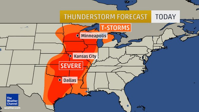
Thursday - May 8th
"The severe weather event Thursday will include damaging wind gusts to 70 mph, large hail, flash flooding and even isolated tornadoes

"The severe weather event Thursday will include damaging wind gusts to 70 mph, large hail, flash flooding and even isolated tornadoes
7:39pm CT: No tornado warning ATTM, but a velocity couplet is located S of Killeen, TX. Storm moving E at 25 mph.
Tornado Warning for Conway, Pope and Van Buren Counties in AR until 9:30 PM CDT
8:53pm CT: Tornado warning issued near Russellville, AR. Rotation detected
Friday
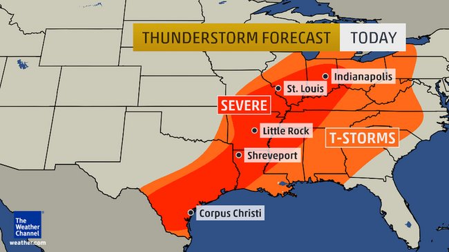
Severe thunderstorms in west-central OH, southern two-thirds of IN, south IL, southeast half of MO, western KY, western TN, northwest half of MS, most of AR except far west, northwest half of LA, southeast third of TX. TOR:CON 2 or less.
Severe thunderstorms in west-central OH, southern two-thirds of IN, south IL, southeast half of MO, western KY, western TN, northwest half of MS, most of AR except far west, northwest half of LA, southeast third of TX. TOR:CON 2 or less.
edit on 9-5-2014 by Havox because: (no reason
given)
I know that right now everyone's attention is turned to the south and eastern US
but here in the Rocky Mountains we have own storm system moving in and it's a real dozy!
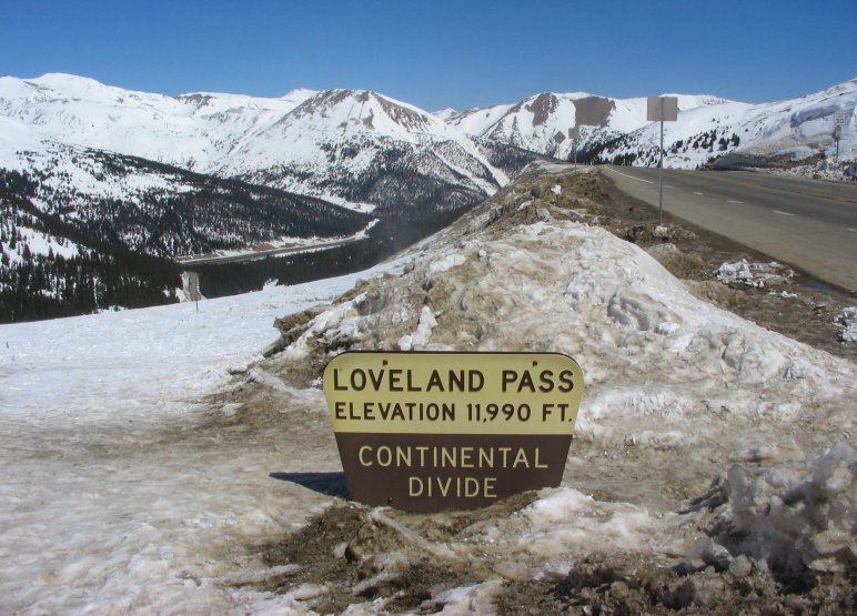
In short their saying we could see up to 2 feet of new snow by Monday in the high country. Rain in the lower valleys of course.
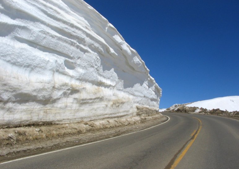
But that's two more feet of snow on top of what we already have.
I'm not kidding when I say the TPTB are really worried about spring flooding here when it comes!
And while those folks are dealing with this newer storm, just wait until next week when this one hitting us tonight get to where you are and mixes with all the warm air coming up from the Gulf.
but here in the Rocky Mountains we have own storm system moving in and it's a real dozy!
Tonight A 40 percent chance of snow showers, mainly before 1am. Some thunder is also possible. Mostly cloudy, with a low around 23. Breezy, with a west wind 15 to 22 mph, with gusts as high as 34 mph. New snow accumulation of less than a half inch possible.
Saturday A slight chance of snow showers before noon, then a chance of rain showers. Some thunder is also possible. Partly sunny, with a high near 44. Breezy, with a west southwest wind 14 to 18 mph, with gusts as high as 30 mph. Chance of precipitation is 40%. Little or no snow accumulation expected.
Saturday Night Snow likely. Some thunder is also possible. Cloudy, with a low around 25. West southwest wind 9 to 13 mph becoming southeast after midnight. Chance of precipitation is 60%. New snow accumulation of 3 to 5 inches possible.
Sunday Snow. High near 30. Breezy, with a southeast wind 11 to 15 mph, with gusts as high as 24 mph. Chance of precipitation is 80%.
Sunday Night Snow likely. Mostly cloudy, with a low around 14. Chance of precipitation is 70%.
Monday A 50 percent chance of snow. Partly sunny, with a high near 30.
Monday Night A chance of snow showers. Mostly cloudy, with a low around 13.
In short their saying we could see up to 2 feet of new snow by Monday in the high country. Rain in the lower valleys of course.
But that's two more feet of snow on top of what we already have.
I'm not kidding when I say the TPTB are really worried about spring flooding here when it comes!
And while those folks are dealing with this newer storm, just wait until next week when this one hitting us tonight get to where you are and mixes with all the warm air coming up from the Gulf.
edit on 9-5-2014 by HardCorps because: (no reason given)
Heads up. Looks like we may be in for more severe weather.
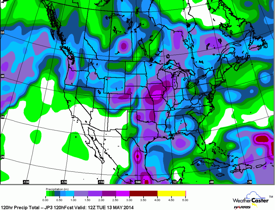
Large Flood Zone Across Central/Eastern United States With Storms Over Next 10 Day Period

link[ed itby]edit on 9-5-2014 by MrLimpet because: (no reason given)
Large Flood Zone Across Central/Eastern United States With Storms Over Next 10 Day Period
A large flood zone is being projected across the Plains, eastward through the East-Central United States, from the Gulf States north to the Great Lake States. Severe storms will accompany the system.
A round of storms will hit the area starting tomorrow for the plains and spreading eastward from there through the red-shaded zones. Very heavy rainfall will accompany all storm system that cross this area over the next 10 day period, bringing flooding. Severe thunderstorms with large hail, damaging winds, and even tornadoes may accompany parts of the shaded zone as well. Those will be addressed the morning of their arrival in official TheWeatherSpace.com alert products.
link[ed itby]edit on 9-5-2014 by MrLimpet because: (no reason given)
TORNADO WARNING continues with strong rotation right over Raymondville to Lyford, TX areas as of 8:55 pm CDT
From Weather 5280
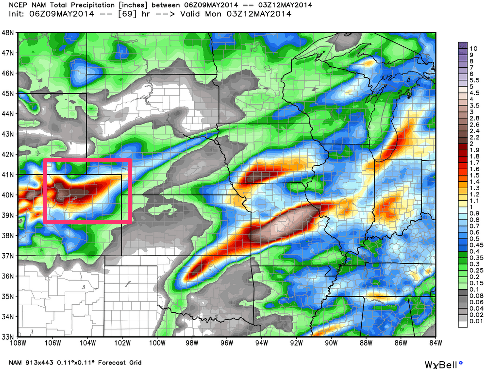
More than 10 inches will break the second heaviest snowfall in Denver set back in 1952.
more than 15 inches and we'll break the all time record set back in the late 1800's!
Below I've posted two 72 hour forecast weather maps. for those of you living east of me here in Colorado, your next for this storm!
Here she come!
Confidence in snowfall accumulation is much greater above 7,000 feet, but all models have accumulating snow in Denver with this storm. Given the rain vs snow uncertainty for the city, totals currently range anywhere from 2 - 16" depending on which model you believe, while totals at higher elevations could easily be in excess of 10".
More than 10 inches will break the second heaviest snowfall in Denver set back in 1952.
more than 15 inches and we'll break the all time record set back in the late 1800's!
Below I've posted two 72 hour forecast weather maps. for those of you living east of me here in Colorado, your next for this storm!
Here she come!