It looks like you're using an Ad Blocker.
Please white-list or disable AboveTopSecret.com in your ad-blocking tool.
Thank you.
Some features of ATS will be disabled while you continue to use an ad-blocker.

Severe Weather Outbreaks 2014
page: 15share:
Just wanted to add that my heart is just sick and worried for all of our friends and neighbors in Ok, Kansas and especially Arkansas, hopefully
members will check in.
Impacts so far:
Arkansas
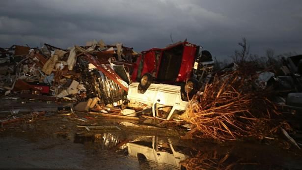
West of Little Rock, the first large tornado formed Sunday night just after 7 p.m. local time. The tornado, which showed a debris signature on radar, moved west of Maumelle and continued on the ground for a long period of time.
The tornado smashed through Vilonia, causing major damage, and also hit El Paso. Additional tornadoes were reported farther northeast near Denmark, Macks, and Jacksonport from the parent thunderstorm. Surveys will determine whether a single long-track tornado continued into those areas or whether several different tornadoes were spawned.
The Arkansas Department of Emergency Management reported at least eight fatalities – 10 in Faulkner County, five in Pulaski County, and one in White County.
Iowa
Strong thunderstorms caused damage across Iowa on Sunday, and at least two tornadoes were spotted in eastern Iowa. The National Weather Service said the storms caused wind damage in a number of Iowa towns as gusts neared 90 mph and hail up to 1-inch in diameter fell. One person was hurt when a barn was blown over near Martinsburg.
One tornado was spotted northeast of Mount Vernon, Iowa, Sunday afternoon. The other tornado was spotted in a field north of Floris, Iowa. At least one farm near Wapello sustained damage to the roof and porch. South of Udell, several farm buildings were damaged or destroyed as the storms moved through. Several trees about one-foot in diameter were snapped off. The roof of the Oskaloosa Family Medical Center in Mahaska was damaged.
Kansas
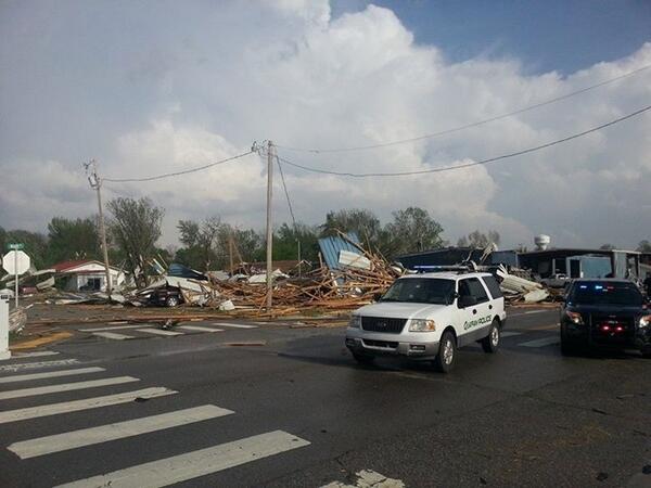
Officials say 25 people were injured and dozens of homes and businesses were destroyed by a tornado in the southeastern Kansas town of Baxter Springs. Southeast Kansas Incident Management Team spokeswoman Kari West said late Sunday night that one person died, but it was not clear whether the death was related to the storm. West said nine of the injured were taken to area hospitals. Their conditions were not immediately available.
West said that search and rescue crews had gone through all of the damaged properties more than once, and everyone was accounted for. The tornado struck around 5:45 p.m. and was roughly three blocks wide, cutting a diagonal through the town of about 4,200 people. It's located six miles north of Quapaw, Okla., where a deadly tornado struck around the same time.
Louisiana
In northwest Louisiana, a teenager suffered minor injuries when a tornado touched down there early Monday.
Bill Davis, a spokesman for the Bossier Parish Sheriff's Office, said the tornado hit around 3:15 a.m. Monday about six miles west of Plain Dealing in mostly a rural area. The teen suffered cuts and bruises and his home was heavily damaged.
Missouri
A large tornado was confirmed on live television Sunday night about 70 miles south of Kansas City on the Kansas/Missouri line in Linn and Bates counties.
A strong line of storms moved through west-central Missouri on Sunday afternoon, bringing winds that reached 70 mph hour near Chillicothe that toppled some trees.
The Missouri Highway Patrol also reported a tractor-trailer was blown onto its side on Interstate 70 near Odessa, about 30 miles east of Kansas City, about 1 p.m. No one was injured.
The weather service received a report from Plattsburg, where an anemometer measured 58 mph before it blew away. Golf ball-sized hail was reported in Trimble, Mo.
KMBC reported that a large tree fell on one house and came to rest against the side of in Kansas City.
Nebraska
At least two tornadoes were confirmed in Nebraska Sunday, the Associated Press reported early Monday.
In rural Upland, Nebraska, a tornado touched down for three minutes but caused no reported damage, National Weather Service confirmed Sunday afternoon. Tornadoes were also spotted on the ground near Stromsburg and Bradshaw.
Oklahoma
One person was killed and six people were injured Sunday after a twister struck the town of Quapaw, according to authorities in Ottawa County, Oklahoma.
The town of about 900 residents suffered heavy damage from the tornado, Ottawa County Emergency Management Director Joe Dan Morgan said.
"Looks like about half of town got extensive damage as well as the fire department," he said in an interview.
Near the Kansas border, the storms Sunday kicked up dust, reduced visibility and caused a multi-car accident in Oklahoma just across the Kansas border and severely reducing visibility farther east.
Tyrone, Okla., fire chief Anthony Adams said blowing dust caused accidents involving 12 vehicles on U.S. 54 one mile south of the Kansas-Oklahoma border near Liberal. KAKE-TV reported that visibility Sunday was reduced to less than 5 feet.
Arkansas
West of Little Rock, the first large tornado formed Sunday night just after 7 p.m. local time. The tornado, which showed a debris signature on radar, moved west of Maumelle and continued on the ground for a long period of time.
The tornado smashed through Vilonia, causing major damage, and also hit El Paso. Additional tornadoes were reported farther northeast near Denmark, Macks, and Jacksonport from the parent thunderstorm. Surveys will determine whether a single long-track tornado continued into those areas or whether several different tornadoes were spawned.
The Arkansas Department of Emergency Management reported at least eight fatalities – 10 in Faulkner County, five in Pulaski County, and one in White County.
Iowa
Strong thunderstorms caused damage across Iowa on Sunday, and at least two tornadoes were spotted in eastern Iowa. The National Weather Service said the storms caused wind damage in a number of Iowa towns as gusts neared 90 mph and hail up to 1-inch in diameter fell. One person was hurt when a barn was blown over near Martinsburg.
One tornado was spotted northeast of Mount Vernon, Iowa, Sunday afternoon. The other tornado was spotted in a field north of Floris, Iowa. At least one farm near Wapello sustained damage to the roof and porch. South of Udell, several farm buildings were damaged or destroyed as the storms moved through. Several trees about one-foot in diameter were snapped off. The roof of the Oskaloosa Family Medical Center in Mahaska was damaged.
Kansas
Officials say 25 people were injured and dozens of homes and businesses were destroyed by a tornado in the southeastern Kansas town of Baxter Springs. Southeast Kansas Incident Management Team spokeswoman Kari West said late Sunday night that one person died, but it was not clear whether the death was related to the storm. West said nine of the injured were taken to area hospitals. Their conditions were not immediately available.
West said that search and rescue crews had gone through all of the damaged properties more than once, and everyone was accounted for. The tornado struck around 5:45 p.m. and was roughly three blocks wide, cutting a diagonal through the town of about 4,200 people. It's located six miles north of Quapaw, Okla., where a deadly tornado struck around the same time.
Louisiana
In northwest Louisiana, a teenager suffered minor injuries when a tornado touched down there early Monday.
Bill Davis, a spokesman for the Bossier Parish Sheriff's Office, said the tornado hit around 3:15 a.m. Monday about six miles west of Plain Dealing in mostly a rural area. The teen suffered cuts and bruises and his home was heavily damaged.
Missouri
A large tornado was confirmed on live television Sunday night about 70 miles south of Kansas City on the Kansas/Missouri line in Linn and Bates counties.
A strong line of storms moved through west-central Missouri on Sunday afternoon, bringing winds that reached 70 mph hour near Chillicothe that toppled some trees.
The Missouri Highway Patrol also reported a tractor-trailer was blown onto its side on Interstate 70 near Odessa, about 30 miles east of Kansas City, about 1 p.m. No one was injured.
The weather service received a report from Plattsburg, where an anemometer measured 58 mph before it blew away. Golf ball-sized hail was reported in Trimble, Mo.
KMBC reported that a large tree fell on one house and came to rest against the side of in Kansas City.
Nebraska
At least two tornadoes were confirmed in Nebraska Sunday, the Associated Press reported early Monday.
In rural Upland, Nebraska, a tornado touched down for three minutes but caused no reported damage, National Weather Service confirmed Sunday afternoon. Tornadoes were also spotted on the ground near Stromsburg and Bradshaw.
Oklahoma
One person was killed and six people were injured Sunday after a twister struck the town of Quapaw, according to authorities in Ottawa County, Oklahoma.
The town of about 900 residents suffered heavy damage from the tornado, Ottawa County Emergency Management Director Joe Dan Morgan said.
"Looks like about half of town got extensive damage as well as the fire department," he said in an interview.
Near the Kansas border, the storms Sunday kicked up dust, reduced visibility and caused a multi-car accident in Oklahoma just across the Kansas border and severely reducing visibility farther east.
Tyrone, Okla., fire chief Anthony Adams said blowing dust caused accidents involving 12 vehicles on U.S. 54 one mile south of the Kansas-Oklahoma border near Liberal. KAKE-TV reported that visibility Sunday was reduced to less than 5 feet.
a reply to: antar
Thank you for saying that. People matter. Always.
Any members in the affected areas, please drop in to this thread or any relevant, related one to let us know you're okay! We're worried about you, okay?
Thank you also to the members here who have been posting up-to-date information, both from the technical side and "on-the-ground" as well.
April 27th, 2014 - Yesterdays Radar Loop
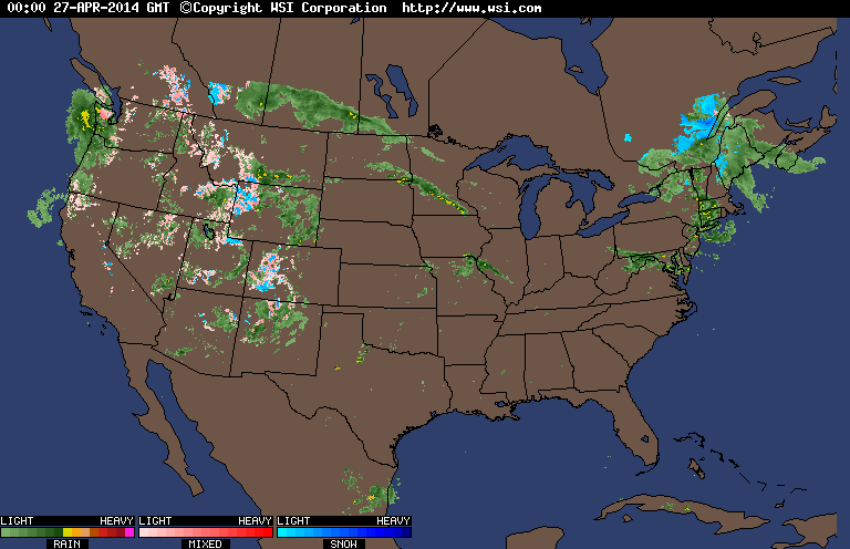 www.intellicast.com...
---------
It will be interesting to see what today has in store...
---------
It will be interesting to see what today has in store...
a reply to: Havox
I checked into this thread late last night. I'm in NW Indiana (actually just broader Chicagoland). Thanks to you & Techxxxx? for updating this thread continually.
We are now getting pounding wind (not unusual, but much more significant than the norm)
and tons of rain. It has been happening through most of the night but has recently intensified
Here is the outlook for anyone in this area; looks like things are OK for now. Yet, if temps increase as day passes than the likelihood for severe storms and/or tornado activity will increase:
[url]http://forecast.weather.gov/showsigwx.phpwarnzone=INZ001&warncounty=INC089&firewxzone=INZ001&local_place1=&product1=Hazardous+Weather+Outlook[/ur l]:
May be, hopefully, not enough of a temperature differential to create the super-cells, but we are under watch for the next few days.
Thanks to ATS community for checking in, and communicating your situations.
I think many times it is not expressed, but know that we all have you in our positive thoughts & it is always awesome news to hear of your well-being.
I checked into this thread late last night. I'm in NW Indiana (actually just broader Chicagoland). Thanks to you & Techxxxx? for updating this thread continually.
We are now getting pounding wind (not unusual, but much more significant than the norm)
and tons of rain. It has been happening through most of the night but has recently intensified
Here is the outlook for anyone in this area; looks like things are OK for now. Yet, if temps increase as day passes than the likelihood for severe storms and/or tornado activity will increase:
[url]http://forecast.weather.gov/showsigwx.phpwarnzone=INZ001&warncounty=INC089&firewxzone=INZ001&local_place1=&product1=Hazardous+Weather+Outlook[/ur l]:
HAZARDOUS WEATHER OUTLOOK
NATIONAL WEATHER SERVICE CHICAGO/ROMEOVILLE IL
423 AM CDT MON APR 28 2014
ILZ003>006-008-010>014-019>023-032-033-039-INZ001-002-010-011-019-
290930-
WINNEBAGO-BOONE-MCHENRY-LAKE ILLINOIS-OGLE-LEE-DE KALB-KANE-
DUPAGE-COOK-LA SALLE-KENDALL-GRUNDY-WILL-KANKAKEE-LIVINGSTON-
IROQUOIS-FORD-LAKE INDIANA-PORTER-NEWTON-JASPER-BENTON-
423 AM CDT MON APR 28 2014 /523 AM EDT MON APR 28 2014/
THIS HAZARDOUS WEATHER OUTLOOK IS FOR NORTH CENTRAL ILLINOIS...
NORTHEAST ILLINOIS AND NORTHWEST INDIANA.
.DAY ONE...TODAY AND TONIGHT.
WEATHER HAZARDS EXPECTED:
SCATTERED THUNDERSTORMS...THE MOST INTENSE COULD PRODUCE:
HEAVY RAIN.
CLOUD TO GROUND LIGHTNING.
HAIL UP TO HALF DOLLAR SIZE.
LOCALLY DAMAGING WINDS OVER 60 MPH.
AND POSSIBLY A TORNADO.
AREAS AFFECTED AND TIMING:
THE GREATEST THREAT OF SEVERE WEATHER IS SOUTH OF INTERSTATE 80
BETWEEN 2 PM AND 10 PM THIS AFTERNOON AND EVENING.
DISCUSSION:
A STRONG WARM FRONT WILL LIFT SLOWLY NORTHWARD INTO NORTHERN
ILLINOIS THIS AFTERNOON...LIKELY STALLING OUT JUST SOUTH OF
INTERSTATE 80. SCATTERED THUNDERSTORMS ARE FORECAST TO DEVELOP
OVER WESTERN CENTRAL ILLINOIS AND ROTATE NORTH INTO THE AREA
LATER THIS AFTERNOON AND LINGERING INTO THIS EVENING. SOME OF
THE STORMS COULD PRODUCE HAIL...POSSIBLY UP TO HALF DOLLAR SIZE.
IN ADDITION...A SOMEWHAT LESSER THOUGH NON ZERO THREAT EXISTS
FOR LOCALLY DAMAGING WINDS AND POSSIBLY A BRIEF TORNADO SOUTH OF
THE WARM FRONT WHERE TEMPERATURES CLIMB WELL INTO THE 60S OR
LOWER 70S. THE INTENSITY OF THE THUNDERSTORMS SHOULD TEND TO
WANE THIS EVENING.
.DAYS TWO THROUGH SEVEN...TUESDAY THROUGH SUNDAY.
THERE IS A CHANCE OF THUNDERSTORMS AGAIN TUESDAY AFTERNOON AND EARLY
EVENING.
.SPOTTER INFORMATION STATEMENT...
SPOTTERS MAY BE NEEDED THIS AFTERNOON AND EVENING SOUTH OF
INTERSTATE 80.
May be, hopefully, not enough of a temperature differential to create the super-cells, but we are under watch for the next few days.
Thanks to ATS community for checking in, and communicating your situations.
I think many times it is not expressed, but know that we all have you in our positive thoughts & it is always awesome news to hear of your well-being.
edit on 28-4-2014 by watchesfromwall because: (no reason given)
edit on 28-4-2014 by watchesfromwall because: (no reason
given)
Morning all.
Thoughts & prayers go out to all of those who were in the path of the storms yesterday.
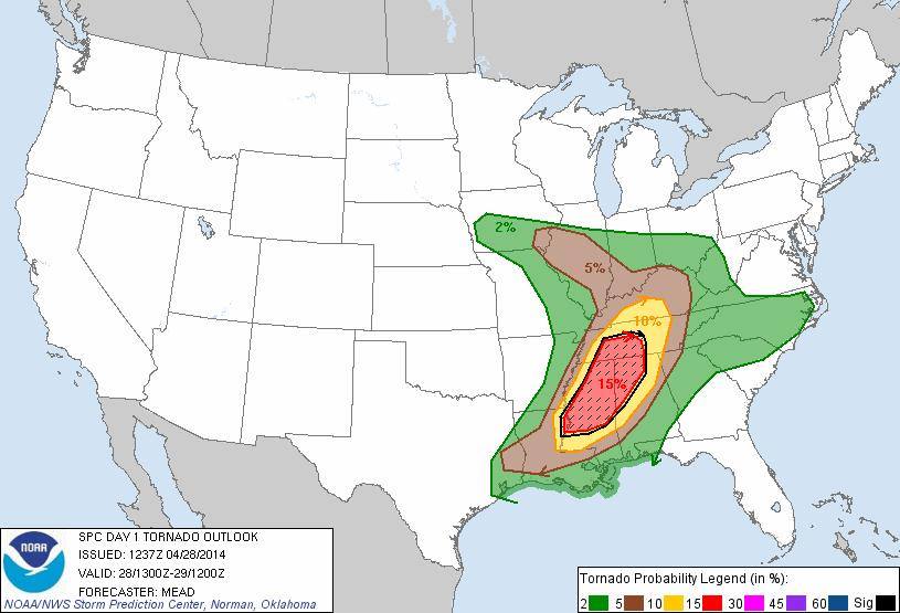
MONDAY - The threat of severe weather is expected in the following areas.
Please stay safe. If you know anyone in these area's, please call to warn them.
•Threat area: Severe thunderstorm and tornado outbreak continues in the regions illustrated in red within the inset map (right). This includes parts of the Mississippi Valley, Ohio Valley and the South.
•Hazards: Damaging winds, large hail and multiple tornadoes possible. Some tornadoes could be strong (EF2 or higher rating). Excessive rainfall could trigger flash flooding.
•Maximum TOR:CON: 7 in parts of Louisiana and Mississippi.
•Cities: Memphis | Nashville | Jackson, Miss. | Birmingham, Ala. | Louisville, Ky.


Thoughts & prayers go out to all of those who were in the path of the storms yesterday.
MONDAY - The threat of severe weather is expected in the following areas.
Please stay safe. If you know anyone in these area's, please call to warn them.
•Threat area: Severe thunderstorm and tornado outbreak continues in the regions illustrated in red within the inset map (right). This includes parts of the Mississippi Valley, Ohio Valley and the South.
•Hazards: Damaging winds, large hail and multiple tornadoes possible. Some tornadoes could be strong (EF2 or higher rating). Excessive rainfall could trigger flash flooding.
•Maximum TOR:CON: 7 in parts of Louisiana and Mississippi.
•Cities: Memphis | Nashville | Jackson, Miss. | Birmingham, Ala. | Louisville, Ky.
edit on 28-4-2014 by MrLimpet because: (no reason given)
a reply to: Havox That was me...i updated a bit ago but it probably got lost in the shuffle, I was able to get to them but they
lost their house along with everyone else but they are safe and that's what matters. Mayflower and Vilonia are just destroyed like a giant brillo
went across them. I40 had a large amount of damage on it as well.
As bad as it is going to sound, had this tornado kept its track and hit Maumelle like it was going to, it would have erased my apartment complex entirely. I havent been near a tornado this bad since i was a kid and the huge line of them hit Ohio (May 31st 1985, pretty big tornado event) We are lucky here that there arent more fatalities, though even one is more than enough, it could have been much much worse.
As bad as it is going to sound, had this tornado kept its track and hit Maumelle like it was going to, it would have erased my apartment complex entirely. I havent been near a tornado this bad since i was a kid and the huge line of them hit Ohio (May 31st 1985, pretty big tornado event) We are lucky here that there arent more fatalities, though even one is more than enough, it could have been much much worse.
a reply to: watchesfromwall
No problem im at work right now will return this evening to update with model analysis and forecast discussions. This outbreak is far from over stay safe ats
No problem im at work right now will return this evening to update with model analysis and forecast discussions. This outbreak is far from over stay safe ats
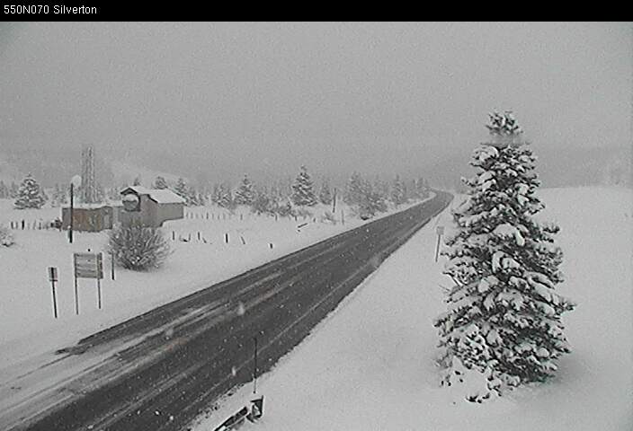
Just a heads up...
Right now in Colorado we're having another blast of winter weather come threw.
fact is they are forecasting impulses of this kind of stuff coming threw for the rest of this week.
Now here's the thing... whatever storm systems we get usually end up in the Midwest a couple days later. and once our cold air mixes with your warmer wetter air coming up out the gulf.
well you all know what that means right?
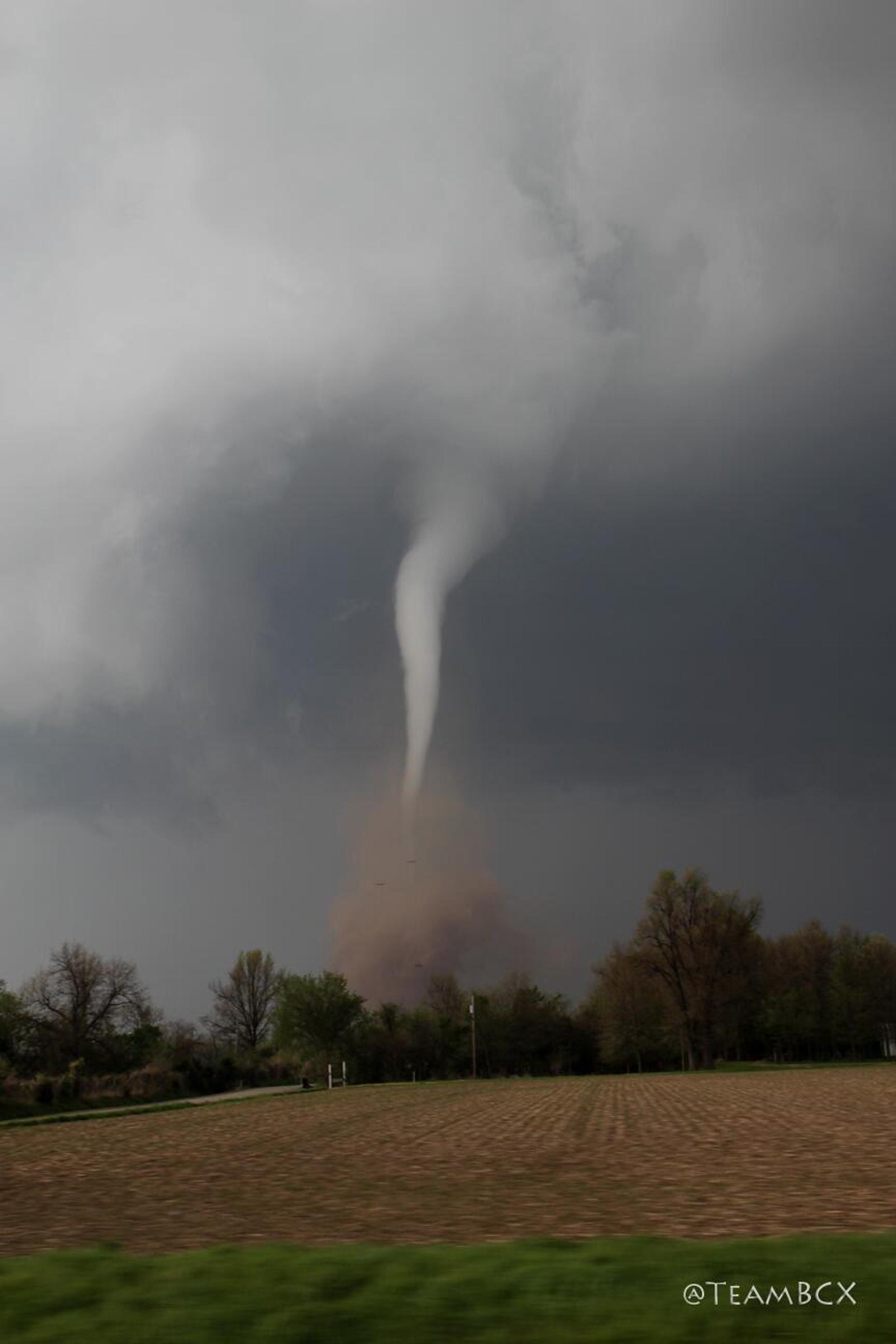
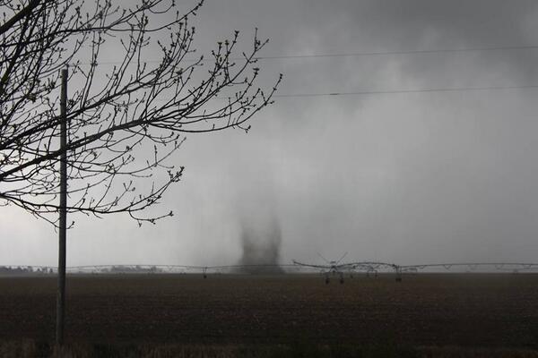
The tornado that hit Baxter Springs, Kansas Sunday evening has been given a preliminary EF2 rating by the NWS
Tornado watch ("particularly dangerous situation") for parts of AL, TN, MS, LA until 9p CT.
Tornado watch ("particularly dangerous situation") for parts of AL, TN, MS, LA until 9p CT.
originally posted by: Havox
The tornado that hit Baxter Springs, Kansas Sunday evening has been given a preliminary EF2 rating by the NWS
Tornado watch ("particularly dangerous situation") for parts of AL, TN, MS, LA until 9p CT.
Yes, if inside the red lines, be very careful...
link
edit on 28-4-2014 by jhn7537 because: (no reason given)
NEW: Increasing tornado threat for ATL. TorCon jumps to 6 (60% chance of tornadoes within 50 mile radius)
Friends in Alabama report public schools are closing, as are colleges & universities. They're scared. Very scared.
As for us here in central KY, the storms that rolled thru earlier this morning & subsequent rain have kept the temps down. We're still at a very low risk for severe later this evening but it will hopefully be a non-event for us.
My thoughts & prayers are with those who have already suffered losses from these storms as well as with those who are still in their paths.
edit on 28-4-2014 by bwick because: clarified location
a reply to: HardCorps
No snow here in the Springs. I think the mountain snowfall has pretty much been dissipating near the I-25 corridor from north to south (which is quite normal). Although we have been hit with some relatively high winds.
No snow here in the Springs. I think the mountain snowfall has pretty much been dissipating near the I-25 corridor from north to south (which is quite normal). Although we have been hit with some relatively high winds.
edit on 28-4-2014 by Wookiep because: (no reason given)
1:20 PM: Storm over Grenada is showing very strong rotation. A tornado could develop at any time
Tornaders?? In tornader alley?? At the start of tornader season?? Ya don't say.
I LOL when the MSM were reporting about a major winter storm in northern Wisconsin this winter. I just shook my head.
But I hope people stay safe. If you're gonna live there then you know that it can happen very fast, so be prepared.
I LOL when the MSM were reporting about a major winter storm in northern Wisconsin this winter. I just shook my head.
But I hope people stay safe. If you're gonna live there then you know that it can happen very fast, so be prepared.
new topics
-
Putin, Russia and the Great Architects of the Universe
ATS Skunk Works: 2 hours ago -
A Warning to America: 25 Ways the US is Being Destroyed
New World Order: 6 hours ago
top topics
-
President BIDEN's FBI Raided Donald Trump's Florida Home for OBAMA-NORTH KOREA Documents.
Political Conspiracies: 12 hours ago, 29 flags -
A Warning to America: 25 Ways the US is Being Destroyed
New World Order: 6 hours ago, 12 flags -
Las Vegas UFO Spotting Teen Traumatized by Demon Creature in Backyard
Aliens and UFOs: 17 hours ago, 7 flags -
Is AI Better Than the Hollywood Elite?
Movies: 14 hours ago, 3 flags -
Maestro Benedetto
Literature: 13 hours ago, 1 flags -
Putin, Russia and the Great Architects of the Universe
ATS Skunk Works: 2 hours ago, 1 flags
active topics
-
Hate makes for strange bedfellows
US Political Madness • 50 • : 19Bones79 -
Weinstein's conviction overturned
Mainstream News • 28 • : burritocat -
Sunak spinning the sickness figures
Other Current Events • 25 • : Ohanka -
Krystalnacht on today's most elite Universities?
Social Issues and Civil Unrest • 5 • : crayzeed -
University of Texas Instantly Shuts Down Anti Israel Protests
Education and Media • 272 • : burritocat -
Gaza Terrorists Attack US Humanitarian Pier During Construction
Middle East Issues • 40 • : WeMustCare -
Cats Used as Live Bait to Train Ferocious Pitbulls in Illegal NYC Dogfighting
Social Issues and Civil Unrest • 24 • : NoviceStoic4 -
A Warning to America: 25 Ways the US is Being Destroyed
New World Order • 13 • : 2025yuga -
Is AI Better Than the Hollywood Elite?
Movies • 19 • : GENERAL EYES -
ChatGPT Beatles songs about covid and masks
Science & Technology • 24 • : iaylyan