It looks like you're using an Ad Blocker.
Please white-list or disable AboveTopSecret.com in your ad-blocking tool.
Thank you.
Some features of ATS will be disabled while you continue to use an ad-blocker.

Quake Watch 2014
page: 79share:
M 2.7 - 47km WNW of Sitka, Alaska
2014-07-21 03:29:37 UTC
47km (29mi) WNW of Sitka, Alaska
147km (91mi) SW of Juneau, Alaska
386km (240mi) S of Whitehorse, Canada
484km (301mi) NW of Prince Rupert, Canada
554km (344mi) NW of Terrace, Canada
earthquake.usgs.gov...
Now Southeast AK is starting to rumble a little bit.
I hope there are no more of those!
M 6.9 - 100km NNE of Ndoi Island, Fiji
Time
2014-07-21 09:54:40 UTC-05:00
Location
19.780°S 178.441°W
Depth
616.1km
Time
2014-07-21 09:54:40 UTC-05:00
Location
19.780°S 178.441°W
Depth
616.1km
There has been a whole lot of shaking on that whole subduction area in the last 4 weeks or so!
Seems like there has been been quite a few 6's!
I wonder if a monster is a brewin.'
Sorry, I was referring to the Tonga- Fiji area and south of there.
Seems like there has been been quite a few 6's!
I wonder if a monster is a brewin.'
Sorry, I was referring to the Tonga- Fiji area and south of there.
edit on 21-7-2014 by radpetey because: (no reason given)
In Vancouver now.
My observation is, if there is ever a M9 or even a M8 on Cascadia, there is going to be major damage here, its a concrete jungle, very dense population.
Especially that overhead Skytrain track, can see those toppling over quite easily.
Leaving late today for home, so hopefully the Jaun de Fuca Plate stays stuck for a least another 12 hours!
edit on 0700000020220214 by muzzy because: (no reason given)
Hi Muzzy. I live in the Vancouver area. The programs I've seen about earthquakes all seem to say that it's the 20-40 story buildings that are most likely to take a lot of damage or collapse in a large earthquake, which is exactly the kind of buildings that makeup downtown Vancouver, and as you say, they are tightly packed together, high density. Apparently it is the taller buidlings that fair better in big quakes, but I don't know if we have any tall enough to be in that category. We recently moved out of the city and live in the new part of south Surrey, are over 200ft above sea level. I feel much better, should Cascadia hit.
originally posted by: muzzy
In Vancouver now.
My observation is, if there is ever a M9 or even a M8 on Cascadia, there is going to be major damage here, its a concrete jungle, very dense population.
Especially that overhead Skytrain track, can see those toppling over quite easily.
Leaving late today for home, so hopefully the Jaun de Fuca Plate stays stuck for a least another 12 hours!
AlexM, I just been over to North Vancouver on the Ferry, that area would do me and probably above 4th st up the hill
The traffic in North Van is terrible during rush hour, getting over those bridges is a pain, I've been in that traffic. But you're right, it's
absolutely beautiful!
a reply to: AlexanderM
Vancouver reminds me a lot like Auckland NZ, but without the freeways (motorways)
Alberta has the space and the freeways are huge there, noticed when we crossed into BC from Alberta near Banff how the roads changed from 4 lane to 2 lanes right away and the BC roads were broken and bumpy.
Amazing what a difference the Tar Sands Oil income has made to Alberta.
China on watch!
they haven't had a M5 on the mainland since 5/04/2014 (M5.1Ms, Sichuan)
China 2014 page
the China Earthquake Networks Center seem to have upgraded their system, double the number of M1's reported since April 2014.
they haven't had a M5 on the mainland since 5/04/2014 (M5.1Ms, Sichuan)
China 2014 page
the China Earthquake Networks Center seem to have upgraded their system, double the number of M1's reported since April 2014.
edit on
07u20420414 by muzzy because: (no reason given)
Well, looks like Southeast AK is still grumbling.
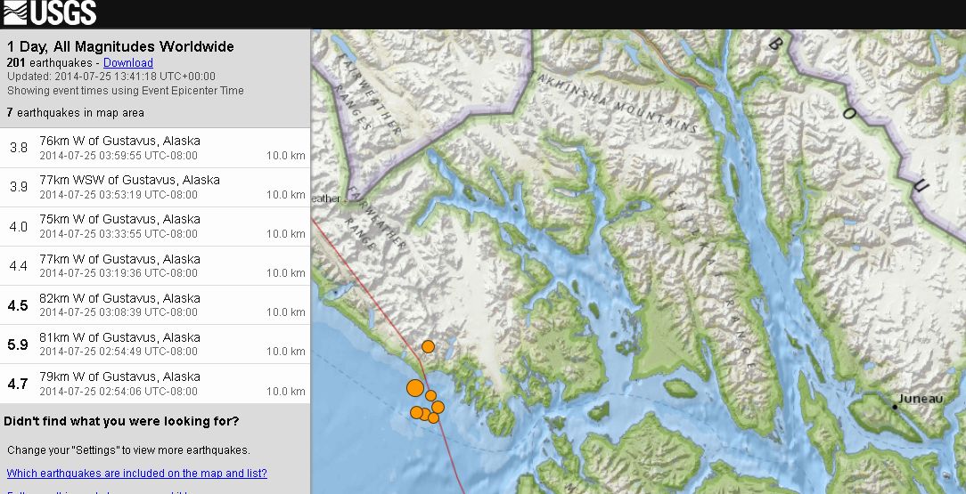
3.8 76km W of Gustavus, Alaska 2014-07-25 06:59:55 UTC-05:00 10.0 km
3.9 77km WSW of Gustavus, Alaska 2014-07-25 06:53:19 UTC-05:00 10.0 km
4.0 75km W of Gustavus, Alaska 2014-07-25 06:33:55 UTC-05:00 10.0 km
4.4 77km W of Gustavus, Alaska 2014-07-25 06:19:36 UTC-05:00 10.0 km
4.5 82km W of Gustavus, Alaska 2014-07-25 06:08:39 UTC-05:00 10.0 km
5.9 81km W of Gustavus, Alaska 2014-07-25 05:54:49 UTC-05:00 10.0 km
4.7 79km W of Gustavus, Alaska 2014-07-25 05:54:06 UTC-05:00 10.0 km
earthquake.usgs.gov...
Good thing most of Southeast Ak is muskeg. It acts as a shock absorber!
edit on 25-7-2014 by Darkblade71 because: (no reason given)
Eketahuna 6.23ML of 20/01/2014 is still shaking after 4073.48hrs (169days, 24weeks, 5months 18days)
just added a few maps to the Eketahuna page based on data I downloaded on 08/07/2014
summary of events: mag1= 2,867, mag2= 883, mag3= 109, mag4= 14, mag5= 0, mag6=1, total= 3,873, total energy released= 34,606.79TTNT
Just yesterday UTC there were 7 events there on the Pa Valley Fault, a M3.45 and 6 x M1's (map)
Still no M5 though!
compare with some other recent M6's in NZ
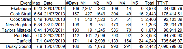
OK I know the table isn't very consistant, I can't help how long a gap there is between M6 events, but that was why I looked at the data again.
So the # days runs as follows;
Eketahuna to 08/07/2012
Cook Strait to Eketahuna
Cook Strait 6.4 to Cook Strait 6.6
New Brighton to 06/07/2012 (Taranaki Bight M6.46, which didn't have an aftershock series, perhaps due to the 253.9 km depth)
Taylors Mistake to New Brighton
Port Hills to Taylors Mistake
Darfield to Port Hills
Dusky Sound to end of 2009
todays project is to make the Dusky Sound page interactive.
just added a few maps to the Eketahuna page based on data I downloaded on 08/07/2014
summary of events: mag1= 2,867, mag2= 883, mag3= 109, mag4= 14, mag5= 0, mag6=1, total= 3,873, total energy released= 34,606.79TTNT
Just yesterday UTC there were 7 events there on the Pa Valley Fault, a M3.45 and 6 x M1's (map)
Still no M5 though!
compare with some other recent M6's in NZ
edit on 07u20520514 by muzzy because: (no reason given)
OK I know the table isn't very consistant, I can't help how long a gap there is between M6 events, but that was why I looked at the data again.
So the # days runs as follows;
Eketahuna to 08/07/2012
Cook Strait to Eketahuna
Cook Strait 6.4 to Cook Strait 6.6
New Brighton to 06/07/2012 (Taranaki Bight M6.46, which didn't have an aftershock series, perhaps due to the 253.9 km depth)
Taylors Mistake to New Brighton
Port Hills to Taylors Mistake
Darfield to Port Hills
Dusky Sound to end of 2009
todays project is to make the Dusky Sound page interactive.
edit on 0700000020520514 by muzzy because: (no reason given)
Public ID: 2014p558062
Date/Time NZST: 26/07/2014 23:35:33
Date/Time UTC: 26/07/2014 11:35:33
Latitude, Longitude: 40.47°S, 173.81°E
Location: o/s NNW of D’Urville Island, Tasman Bay [GL15924]
Depth: 161 Km
Magnitude: 4.4
www.geonet.org.nz...
Reported felt as;
Moderate [121]: Aramoho, Awapuni, Belmont, Cannons Creek [2], Castlecliff, Eastbourne, Eketahuna [2], Feilding, Foxton [3], Greytown [3], Karori [2], Khandallah, Levin [4], Lower Hutt [4], Martinborough, Masterton [6], Matahiwi [3], Maupuia, Mauriceville, Motueka, Naenae, Nelson [4], Newlands, Newtown [3], Opiki, Otaki, Paekakariki [5], Palmerston North [4], Parapara, Paraparaumu [13], Paraparaumu Beach [5], Porirua [3], Raumati Beach [6], Raumati South [8], Stokes Valley, Strathmore Park, Taihape, Tawa [2], Te Aro [3], Te Horo, Te Ore Ore, Thorndon [2], Tirohanga [2], Titahi Bay [3], Whitby [8]
Slight [12]: Aokautere, Carterton, Featherston, Hokowhitu, Kelson, Miramar, Monaco, Paparangi, Upper Hutt, Waikanae Beach, Wanganui East, Waverley
Total 133
First warning out for M5+ New Zealand, the 24hr TTNT energy release dropped to 6 on the 25th.
edit on 0700000020620614 by muzzy because: (no
reason given)
6.0 - Kane Fracture Zone
well why call it Northern Mid-Atlantic Ridge when all the other USGS location names are obscure?
2014-07-27 01:28:38 UTC
23.761°N 45.646°W
10.0km
earthquake.usgs.gov...
bound to come down, GFZ have 5.5 and RAS have 5.6mb
well why call it Northern Mid-Atlantic Ridge when all the other USGS location names are obscure?
2014-07-27 01:28:38 UTC
23.761°N 45.646°W
10.0km
earthquake.usgs.gov...
edit on 0700000020620614 by muzzy because: (no reason given)
bound to come down, GFZ have 5.5 and RAS have 5.6mb
edit on 07u20620614 by muzzy because: (no reason given)
I hope this Topic isn't going to go the way of the Japan Preliminary EQ Topic, where I ended up being the only poster!
I know its hot up there, been there done that, but I spent a bit of time on the computer when it was hot, get in the shade and cool down!.
Only Mad Dogs and Englishmen only go out in the mid-day sun, (only Brit Empire song)
Couple of generations back qualifies me for the later.
ha! the Kane Fracture Zone quake didn't come down yet, but GFZ went up (on conversion to Mw to 6.1)
EMSC still the same
edit on 0700000020720714 by muzzy because: (no reason given)
1. Back home now, been working on the Dusky Sound 2009 quake and aftershocks, got as far as 4 weeks of aftermath, quite a bit of work involved, not
only has Google maps depleted the i-frame editing options, but now Wordpress won't allow map images with links to larger version, I had to work the
bugs out of those issues first. Some of my other posts on EQ Archives are now missing Timeline Graphs, why can't they just leave stuff alone!!
that page
I'll keep working on that to the end of 2009, laptop is going slow, need to reboot.
2. I was looking at Geofon yesterday and thought hmmm, quite a few Deep quakes near Fiji, wondered if this was usual, so went and got some deep data from GFZ and GNS, 150km and deeper.
Have used Global Seismic Archives to put the maps on, had run out of material for that Blog recently. Done 4 weeks worth of maps so far.
Looks sort of normal, based on 7 days worth at a time. Will go back a bit further to see whats up.
Keep in mind the icons are based on depth, not magnitude.
Edit: just had another look at the 4 maps, activity seems quite high SW and NE of Ona Llau Island (Lau Group to the south) this last week and 2 weeks ago.
There was a M7.2 @600km deep on 1910/12/14 SE of Ona Llau Island. Probably been others as big as well since, that one came up off my Significan EQ pages, but search is only as good as what is put in there in the first place, most of the quakes there are just listed as "Fiji".
Not sure what it means, if anything. Digging "deeper" pardon the pun, on ANSS.
3. I see RAS has finally fixed the "Choice by date:" field after over 6 years!, always had the year date wrong, so you had to fix that before clicking the GO arrow, I always thought it might be to stop robots accessing the data. Maybe just no one noticed it!
edit on 07u20720714 by muzzy because: (no reason given)
edit on 0700000020720714 by muzzy because: (no reason
given)
a reply to: muzzy
Welcome home!
Hope you didn't get jet lag!
What a lot of work on that!
I could tell before I even saw it, by how long it took to load!
Lately this thread is as empty as a Christmas store in April!
I guess people do have lives outside of ATS?
Give it a few months, they'll be back when the weather gets crappy!
I noticed NOAA has that quake as a 6.6, but no scale listed.
www.tsunami.gov...
They do have Alaska the same at 5.9, but they have Fiji a 6.8.
It has to stay Owen, because that's one of my grandsons names,
& he's excited whenever there is an eq in his zone!!! Ha, ha!
WOQ
a reply to: wasobservingquietly
Thanks. Yeah was a bit tired the first 2 days back.
Its the COLD thats the worst, from 25/30C down to 10/11C, .............. chilly.
Maybe those quakes around Ona Llau Island are just aftershocks of the 6.6 (6.8) of 21/07/2014, although deep quakes rarely have aftershocks
Has the potential for a M7+ within 150km of Ona Llau, but no 8's on the Lau Ridge recorded, yet.
Date/Time, Lat, Long, Depth, Mag
19/08/2002 11:01, -21.696, -179.513, 580, 7.7Mw
5/08/1996 22:38, -20.69, -178.31, 550.2, 7.4Me
15/09/2011 19:31, -21.611, -179.528, 644.6, 7.3Mw
2/01/2006 22:13, -19.926, -178.178, 582.9, 7.2Mw
ANSS
edit on 07u20720714 by muzzy because: (no reason given)
originally posted by: muzzy
.............. Some of my other posts on EQ Archives are now missing Timeline Graphs, why can't they just leave stuff alone!!
my mistake.
the page in question was the L'Aquila 2009 page on EQ Archives, the timeline graphs and town table images were missing.
On checking the HTML code I found that I had saved the images directly to Wordpress Media, on the Italy Blog, and I later deleted the entire Blog ( due to lack of readers), so the images disappeared!
Luckily I still had the graphs themselves on file (Excel) so have been able to reload them (Dropbox).
All is good again, apologies to Wordpress, it wasn't their fault.
Doh
edit on 0700000020820814 by muzzy because: (no reason given)
I added another graph to that page, 30 days timeline interesting the way its wavy...............
dl.dropboxusercontent.com...
edit on 07u20820814 by muzzy because: (no reason
given)
M4.0 - 24km WSW of Medford, Oklahoma
2014-07-29 02:46:36 UTC
Nearby Cities
24km (15mi) WSW of Medford, Oklahoma
38km (24mi) NNW of Enid, Oklahoma
80km (50mi) W of Ponca City, Oklahoma
92km (57mi) WSW of Arkansas City, Kansas
146km (91mi) NNW of Oklahoma City, Oklahoma
earthquake.usgs.gov...
I bet that got a few peoples attention.
2014-07-29 02:46:36 UTC
Nearby Cities
24km (15mi) WSW of Medford, Oklahoma
38km (24mi) NNW of Enid, Oklahoma
80km (50mi) W of Ponca City, Oklahoma
92km (57mi) WSW of Arkansas City, Kansas
146km (91mi) NNW of Oklahoma City, Oklahoma
earthquake.usgs.gov...
I bet that got a few peoples attention.

new topics
-
OBAMA ordered illegal SPYING on TRUMP and BIDEN ordered the illegal RAID on TRUMP.
Political Conspiracies: 3 hours ago -
Howdy Ya’ll!
Introductions: 3 hours ago -
Doctors Predict Epidemic of Prion Brain Diseases From mRna Jab
Health & Wellness: 5 hours ago -
Numerous officers hurt in active east Charlotte shooting
Breaking Alternative News: 6 hours ago -
Israeli Officials Believe International Court Is Preparing Arrest Warrants Over War
Middle East Issues: 9 hours ago -
Fani Willis a No Show at Democrat DA Opponent Debates
US Political Madness: 10 hours ago
top topics
-
German city in chaos as 'extremist' march sees calls for 'caliphate' and ISIS-style flags
Mainstream News: 12 hours ago, 25 flags -
OBAMA ordered illegal SPYING on TRUMP and BIDEN ordered the illegal RAID on TRUMP.
Political Conspiracies: 3 hours ago, 15 flags -
Shocking moment four men 'try to force Jewish pedestrian into car boot' in North London
Breaking Alternative News: 17 hours ago, 14 flags -
Doctors Predict Epidemic of Prion Brain Diseases From mRna Jab
Health & Wellness: 5 hours ago, 14 flags -
Fani Willis a No Show at Democrat DA Opponent Debates
US Political Madness: 10 hours ago, 13 flags -
Numerous officers hurt in active east Charlotte shooting
Breaking Alternative News: 6 hours ago, 13 flags -
Israeli Officials Believe International Court Is Preparing Arrest Warrants Over War
Middle East Issues: 9 hours ago, 7 flags -
College protesters want amnesty.
US Political Madness: 13 hours ago, 6 flags -
Howdy Ya’ll!
Introductions: 3 hours ago, 3 flags
active topics
-
Howdy Ya’ll!
Introductions • 8 • : BingoMcGoof -
James O’Keefe: I have evidence that exposes the CIA, and it’s on camera.
Whistle Blowers and Leaked Documents • 37 • : pianopraze -
Psychotronic Operation Rwanda Who Wants To Be A Refugee?
ATS Skunk Works • 12 • : NoCorruptionAllowed -
SC Jack Smith is Using Subterfuge Tricks with Donald Trumps Upcoming Documents Trial.
Dissecting Disinformation • 116 • : Xtrozero -
College protesters want amnesty.
US Political Madness • 81 • : Xtrozero -
Doctors Predict Epidemic of Prion Brain Diseases From mRna Jab
Health & Wellness • 13 • : chr0naut -
New Bombshell Evidence Strongly Suggests Trump was Set Up in Classified Docs Saga
US Political Madness • 61 • : Justoneman -
Gov Kristi Noem Shot and Killed "Less Than Worthless Dog" and a 'Smelly Goat
2024 Elections • 144 • : DBCowboy -
Candidate TRUMP Now Has Crazy Judge JUAN MERCHAN After Him - The Stormy Daniels Hush-Money Case.
Political Conspiracies • 840 • : Annee -
Israeli Officials Believe International Court Is Preparing Arrest Warrants Over War
Middle East Issues • 42 • : DBCowboy