It looks like you're using an Ad Blocker.
Please white-list or disable AboveTopSecret.com in your ad-blocking tool.
Thank you.
Some features of ATS will be disabled while you continue to use an ad-blocker.

West Coast USA: Pay Attention, Cascadia May Be Ready to Rupture
page: 5share:
reply to post by ThinkingCap
Sasquatch attack is one.
Gang of Sasquatches attacking is another.
Sasquatch attack is one.
Gang of Sasquatches attacking is another.
edit on 5-2-2012 by SeriousIndividual because: (no reason given)
reply to post by Corruptedstructure
That thought crossed my mind....could be...I did not see anything...came damn close to landing on my roof by the sound of it...
That thought crossed my mind....could be...I did not see anything...came damn close to landing on my roof by the sound of it...
reply to post by dreamingawake
@dreamingawake - WELL SAID! I live in vancouver part time and mexico the other time. I just went through a little drill with family members to solidify a plan of meeting point etc! This was prompted by this topic coming up again. Of course, this can happen at any given time and you cannot plan on where you're going to be but it gives me some comfort that a plan of action is in place...better to be prepared as best you can. I also watched some footage of 2004 tsunami in Indonesia and Japan. It was so awful to watch it again, but we need these reminders to have gratitude every day and to most importantly have the knowledge of what can happen and be best prepared. In one of the videos for Indonesia, an american young boy had told his family the day before boxing day, that he had had a terrible dream about devastation hitting thailand the next day. I follow threads that cover people premonitions, dreams and although some may be outlandish, you can decipher the threads that may have something solid to them. Anyways, I enjoy every moment that I can and I live life to the fullest..and I am grateful for people who post threads to wake us up and to prepare for what I think we all know is inevitable.
@dreamingawake - WELL SAID! I live in vancouver part time and mexico the other time. I just went through a little drill with family members to solidify a plan of meeting point etc! This was prompted by this topic coming up again. Of course, this can happen at any given time and you cannot plan on where you're going to be but it gives me some comfort that a plan of action is in place...better to be prepared as best you can. I also watched some footage of 2004 tsunami in Indonesia and Japan. It was so awful to watch it again, but we need these reminders to have gratitude every day and to most importantly have the knowledge of what can happen and be best prepared. In one of the videos for Indonesia, an american young boy had told his family the day before boxing day, that he had had a terrible dream about devastation hitting thailand the next day. I follow threads that cover people premonitions, dreams and although some may be outlandish, you can decipher the threads that may have something solid to them. Anyways, I enjoy every moment that I can and I live life to the fullest..and I am grateful for people who post threads to wake us up and to prepare for what I think we all know is inevitable.
Not sure if anyone is of the zeta talk website. But from them they are saying Planet X or Nibiru is causing most earthquakes around the world because
its gravity is tugging on earth causing stress at fault lines, which results in an earthquake.
Per zetatalk website
Food for thought
Per zetatalk website
Where Vancouver Island lies entirely on the Juan de Fuca Plate, but this plate is not homogeneous. It is composed of different rock strata, and as we have noted in explaining why the Seaway rips as it does on the N American continent, rock strata do not bond firmly to one another. The Strait of Juan de Fuca passes Vancouver Island where 3 different such rock strata abut each other in close succession, and thus the Leech River Fault. A jolt to the Juan de Fuca Plate, because of adjustments in the Pacific following the Japan quakes, will cause these strata to slip. Where this might create sinkholes or other such minor changes in the ground along the Leech River Fault, it will certainly set the deep water in the straits to sloshing. Victoria is at an extremely low sea level elevation, and Victoria West and James Bay which are AT sea level will be swamped by this sloshing. Towns elsewhere along the straits or on neighboring islands have more protection in elevation. Much of Victoria will find water in its streets to a depth of 20 feet, with little warning as the reaction to the Japan quakes will come across the Pacific from plates pushing plates with lightning speed. This is not a tsunami.
Along the rugged west coast of North America, British Columbia will experience some of the plate subduction problems troubling the western part of the United States, but with a difference. Canada, in this area, will be stretched, with it's upper part attached to the all the way over the North Pole, into Russia. As the western United States is pushed and crumpled, the lands it is attached to will be stretched. This tends to alleviate any crumpling that occurs due to the subducting Pacific plate, a trade-off. Nevertheless, this makes for a rugged ride, as these adjustments are never smooth, here crumpling, there stretching, so being on solid rock to lessen the impact is wise. Solid rock is less likely to crumple or shift, the pressure shifting to soil or broken rocks nearby. In addition, the southern portion of British Columbia is close the Mt. St. Helen volcano, which will surly erupt during the shift, at times violently. Firestorms are created due to air turbulence over volcanoes, the super-heated air creating petrochemicals drifting in the tail of the 12th planet, which is lashing the Earth's atmosphere as the 12th Planet passes between the Earth and the Sun. Thus, where these walls of fire can fall anywhere, they are more likely in the vicinity of volcanoes. Winds will move in all directions, in chaos, during the hour of the shift. Those living near volcanoes or in forested areas that can be set afire should seek shelter in the earth, in bermed structures or those with metal or sod roofs, until the hour of the shift has passed. Cities clustered along the Continental Divide, particularly in what is now the southern portions of British Columbia, will find the ride through the pole shift particularly stressful. The Continental Divide represents the point of pressure where subducting plates have forced themselves under overplates, and thus this will be the point there the divide moves further inland. Thus, sudden breaks in the rock, rock stratas jerking suddenly upwards and no longer level where they were before, can be expected. Water mains, housing, roads and bridges, and even the direction that rivers flow will be disrupted. After the shift, British Columbia will be well situated, with a warm climate near the ocean, and high ground that will be above the water line when the poles have melted.
Food for thought
reply to post by TrueAmerican
Much appreciate your
1. courage in saying so.
2. all your perceptive tireless efforts at observing and analyzing such stuff.
3. Sharing your skill set and caring so faithfully hereon.
Who knows how many lives you may end up saving.
Much appreciate your
1. courage in saying so.
2. all your perceptive tireless efforts at observing and analyzing such stuff.
3. Sharing your skill set and caring so faithfully hereon.
Who knows how many lives you may end up saving.
Originally posted by violence=answer
do you know, or anyone here know, have a theory on, or research about, what will happen to the puget sound when "the big one" hits?
with so many islands, hills, and mountains, things like that everywhere, would there be a tsunami and how would it go where and do what in the puget sound area?
at what elevation would people be safe in?
a quake could trigger a eruption,causing lahars on the east side of the sound, and tsunamis (maybe?) from the west at the same time?
Have long wondered the same thing.
Please let me know if anyone comes up with something.
I have loved ones in the area.
Sigh.
reply to post by PuterMan
5 miles inland from all the shorelines
or from the outermost West Coast line or what?
If Mr Rainier goes of in a similar time frame . . . May God have mercy on the huge area around the Southern half or more of Pudget Sound.
Sigh.
5 miles inland from all the shorelines
or from the outermost West Coast line or what?
If Mr Rainier goes of in a similar time frame . . . May God have mercy on the huge area around the Southern half or more of Pudget Sound.
Sigh.
Again per zeta talk:
Puget Sound will be flooded past human memory during the hour of the shift, due to water pouring in from the compressing Pacific, which will take time to drain, and water from torrential rainstorms pouring into the sound from the rivers that empty into the sound. Surrounded by mountains, residents in the area should seek high places but be mindful of tidal bore, which can astonish those unfamiliar with what water will do under pressure and with no place to go but up. After the shift, due to higher sea levels caused by the melting poles, the sound will increase in size, giving better access to the Pacific for good ocean fishing.
Puget Sounds is a geologically complex area, with many faults. The Juan de Fuca Plate is pushing under the region, creating the belt of volcanoes in the Cascade Range. As the Juan de Fuca Plate is moving northward as well as subducting under the N American Plate, Vancouver Island is moving north, and is expected to move up to 100 miles further north during this coming pole shift. What will the pole shift mean for Puget Sound, beyond what we have predicted for pole shift tidal waves up to 600 feet high and rising seas - a loss of elevation of 675 feet within 2 years following the pole shift? Due to the complexity of the sound, with so many islands and peninsulas, there will be a baffling effect from any tsunami coming in from the Juan de Fuca Straits. This will help disburse the 100 foot tsunami expected to bore through the straits, swamping Victoria, especially as the tsunami will blow both north and south after leaving the straits. Despite cities like Seattle and Vancouver, BC being below a 100 foot elevation in the main, these cities are unlikely to be swamped by the tsunami coming from the great Japan quakes. But for the pole shift tides matters will be different. These tides are anticipated to be 500 foot high, with an additional 100 foot in height when tidal bore factors are present. Most of Puget Sound is lowlands, so much so that the entire region can be expected to be flooded during the hour of the pole shift. Where a single tsunami wave of 100 feet is expected to disburse, the pole shift tides are the entire ocean on the move. Lots of water, so that the whole coastal region is presented with water at this height. Tidal bore will occur in the narrow Juan de Fuca Straits, but this time not disburse. A 600 foot high tide will wash down into the sound, and up along the Washington coastline before dropping to a 500 foot level. ZetaTalk ™
Folks, apologies if this has already been brought up. I can't help but wonder did swarm activity signal the 5.7M quake off BC. see for swarm
old.pnsn.org...
This initial swarm was started at 1AM on the 4th with the center of the swarm at approximately 48.9 lat and 123.8 long. These tremors are probably caused by the leading edge of the Juan de Fuca plate as it subducts under the North American plate. This would be the area that has subducted and is beginning to melt and break free from the plate, moving into the asthenosphere.
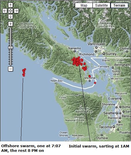
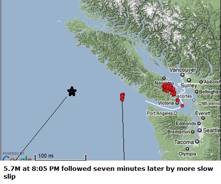
At 7:07 AM a slow slip tremor occurred east of the swarm at 48.6 lat and 125.9 long. At 8:05 PM, a 5.7M hit at 48.8 lat and 127.8 long. This was then followed 7 minutes later with some more slow slip activity occurring at the site of the 7:07 tremor, with only one slow slip tremor occurring at the original onshore swarm site from this point on.
The main swarm was at 123.8 long, the mid swarm at 125.9 long, and the main quake at 127.8 long. A coincidence? Maybe yes, maybe no. I can't remember a pattern like this but it's only been recently that Ive been following swarms. I'm pretty sure the mid swarm is a foreshock with later aftershocks starting right after the main quake.
It might be worth checking to see if this pattern of a tear or slow slip occurring mid way between a swarm and the main quake has happened before. I know the Tohoku earthquake was preceded by a swarm, but I don't know anything else about it.
This initial swarm was started at 1AM on the 4th with the center of the swarm at approximately 48.9 lat and 123.8 long. These tremors are probably caused by the leading edge of the Juan de Fuca plate as it subducts under the North American plate. This would be the area that has subducted and is beginning to melt and break free from the plate, moving into the asthenosphere.
At 7:07 AM a slow slip tremor occurred east of the swarm at 48.6 lat and 125.9 long. At 8:05 PM, a 5.7M hit at 48.8 lat and 127.8 long. This was then followed 7 minutes later with some more slow slip activity occurring at the site of the 7:07 tremor, with only one slow slip tremor occurring at the original onshore swarm site from this point on.
The main swarm was at 123.8 long, the mid swarm at 125.9 long, and the main quake at 127.8 long. A coincidence? Maybe yes, maybe no. I can't remember a pattern like this but it's only been recently that Ive been following swarms. I'm pretty sure the mid swarm is a foreshock with later aftershocks starting right after the main quake.
It might be worth checking to see if this pattern of a tear or slow slip occurring mid way between a swarm and the main quake has happened before. I know the Tohoku earthquake was preceded by a swarm, but I don't know anything else about it.
Remember Feb. 7th is the Great American Shakeout:
www.shakeout.org...
I have close family in Northern cal, so I hope this is not going to be something huge...
www.shakeout.org...
I have close family in Northern cal, so I hope this is not going to be something huge...
reply to post by zworld
Hey there Zworld...do me a favor, would ya? Start a thread on this. I think it needs its own.
I looked last night to check for any deep tremor (as I do every night) and it hadn't been updated. I didn't see his. There haven't been any swarms for many, many days now. I have noticed certain patterns of the past couple of years. I could just talk about this on my deep tremor thread, but I think this needs its own....
reply to post by zworld
Wow Z....that doesn't sound good at all. I would be a nervous wreck if I lived there.
Wow Z....that doesn't sound good at all. I would be a nervous wreck if I lived there.
Originally posted by zworld
Folks, apologies if this has already been brought up. I can't help but wonder did swarm activity signal the 5.7M quake off BC. see for swarm old.pnsn.org...
This initial swarm was started at 1AM on the 4th with the center of the swarm at approximately 48.9 lat and 123.8 long. These tremors are probably caused by the leading edge of the Juan de Fuca plate as it subducts under the North American plate. This would be the area that has subducted and is beginning to melt and break free from the plate, moving into the asthenosphere.
At 7:07 AM a slow slip tremor occurred east of the swarm at 48.6 lat and 125.9 long. At 8:05 PM, a 5.7M hit at 48.8 lat and 127.8 long. This was then followed 7 minutes later with some more slow slip activity occurring at the site of the 7:07 tremor, with only one slow slip tremor occurring at the original onshore swarm site from this point on.
The main swarm was at 123.8 long, the mid swarm at 125.9 long, and the main quake at 127.8 long. A coincidence? Maybe yes, maybe no. I can't remember a pattern like this but it's only been recently that Ive been following swarms. I'm pretty sure the mid swarm is a foreshock with later aftershocks starting right after the main quake.
It might be worth checking to see if this pattern of a tear or slow slip occurring mid way between a swarm and the main quake has happened before. I know the Tohoku earthquake was preceded by a swarm, but I don't know anything else about it.
If you look closely on that map you'll see a little tiny city called Richmond.It's twenty minutes south of down town Vancouver.I grew up on that little sand bar over 30 years ago and then it was all just farming and small communities.I remember when it rained and we lived in east Richmond for awhile you could go out in our back yard and bounce on the ground and watch it ripple across the yard, in some spots it was basically just peat moss and water underneath.Now if you go to Richmond it is a huge city with skyscrapers and high rise apartments and hundreds of thousands of people, plus Vancouver's billion dollar main airport and sky train are located there as well.I new fifteen years ago that when the Cascadia region finally snapped, Richmond would be absolutely destroyed by the liquifaction of the sand and collapse of all buildings plus any Tsunami would leave nothing in its wake.Richmond lies at the mouth of the Fraser river and is basically a large sand bar.It is dyked all the way around because it lies in some places ten feet or more below the water level of the Fraser river.This among many places is the place we need to worry about.This area will be completely wiped out by a quake and or a tsunami.
I left fifteen years ago taking my son and moving to the interior of British Columbia because I new this area would not survive a huge event which is coming.I am four hours from Vancouver now which is roughly four hundred kilometers inland and I am at several thousand feet above sea level.
I still have a lot of friends and family that live in the Fraser Valley and the lower mainland and I fear for their safely and have been for a long time.I hope that the big one is still thousands of years away and maybe by then science will have figured out a way to somehow understand earthquakes and find ways to ease the pressures and save lives and property. But for now when ever there is a fairly large earthquake on the coast I pause and worry because the region has been very quiet of late. While earthquakes still ripple up and down the California coast and Alaska almost daily, earthquakes off the coast of B.C. have been few and far between.It seems like the pressure in that region is building as the surrounding plates squeeze on it from both sides.
Any ways, a good thread with good information and I will be watching events closely.I pray for every one who lives up and down the coast of California and British Columbia.Get ready and hold on. Peace.
edit on 5-2-2012 by Obelisk67 because: typo
Originally posted by Obelisk67
Originally posted by zworld
Folks, apologies if this has already been brought up. I can't help but wonder did swarm activity signal the 5.7M quake off BC. see for swarm old.pnsn.org...
This initial swarm was started at 1AM on the 4th with the center of the swarm at approximately 48.9 lat and 123.8 long. These tremors are probably caused by the leading edge of the Juan de Fuca plate as it subducts under the North American plate. This would be the area that has subducted and is beginning to melt and break free from the plate, moving into the asthenosphere.
At 7:07 AM a slow slip tremor occurred east of the swarm at 48.6 lat and 125.9 long. At 8:05 PM, a 5.7M hit at 48.8 lat and 127.8 long. This was then followed 7 minutes later with some more slow slip activity occurring at the site of the 7:07 tremor, with only one slow slip tremor occurring at the original onshore swarm site from this point on.
The main swarm was at 123.8 long, the mid swarm at 125.9 long, and the main quake at 127.8 long. A coincidence? Maybe yes, maybe no. I can't remember a pattern like this but it's only been recently that Ive been following swarms. I'm pretty sure the mid swarm is a foreshock with later aftershocks starting right after the main quake.
It might be worth checking to see if this pattern of a tear or slow slip occurring mid way between a swarm and the main quake has happened before. I know the Tohoku earthquake was preceded by a swarm, but I don't know anything else about it.
If you look closely on that map you'll see a little tiny city called Richmond.It's twenty minutes south of down town Vancouver.I grew up on that little sand bar over 30 years ago and then it was all just farming and small communities.I remember when it rained and we lived in east Richmond for awhile you could go out in our back yard and bounce on the ground and watch it ripple across the yard, in some spots it was basically just peat moss and water underneath.Now if you go to Richmond it is a huge city with skyscrapers and high rise apartments and hundreds of thousands of people, plus Vancouver's billion dollar main airport and sky train are located there as well.I new fifteen years ago that when the Cascadia region finally snapped, Richmond would be absolutely destroyed by the liquifaction of the sand and collapse of all buildings plus any Tsunami would leave nothing in its wake.Richmond lies at the mouth of the Fraser river and is basically a large sand bar.It is dyked all the way around because it lies in some places ten feet or more below the water level of the Fraser river.This among many places is the place we need to worry about.This area will be completely wiped out by a quake and or a tsunami.
I left fifteen years ago taking my son and moving to the interior of British Columbia because I new this area would not survive a huge event which is coming.I am four hours from Vancouver now which is roughly four hundred kilometers inland and I am at several thousand feet above sea level.
I still have a lot of friends and family that live in the Fraser Valley and the lower mainland and I fear for their safely and have been for a long time.I hope that the big one is still thousands of years away and maybe by then science will have figured out a way to somehow understand earthquakes and find ways to ease the pressures and save lives and property. But for now when ever there is a fairly large earthquake on the coast I pause and worry because the region has been very quiet of late. While earthquakes still ripple up and down the California coast and Alaska almost daily, earthquakes off the coast of B.C. have been few and far between.It seems like the pressure in that region is building as the surrounding plates squeeze on it from both sides.
Any ways, a good thread with good information and I will be watching events closely.I pray for every one who lives up and down the coast of California and British Columbia.Get ready and hold on. Peace.edit on 5-2-2012 by Obelisk67 because: typo
good for mentioning Richmond, everyone who lives in Vancouver knows that during an earthquake, Richmond will sink due to liquefaction, it seems to be common knowledge. the problem is we have nothing to compare it to.
the last great earthquake was 311.5 years ago, when there was no settlers.
we don't necessarily know 100% that it will or will not.
the danger living in Richmond, is with the tunnel and bridges as the only means for escape.
there is no risk for tsunami in Lower Mainland due to the Gulf/San juan Islands and Vancouver Island.
at most, a very high tide. Richmond's risk is also the shaking, which will cause the Delta to begin to sink the city into the strait.
I'm in Surrey, don't worry, the quake is the biggest issue for us, and it is survivable depending on how quickly you react and where you are
reply to post by yourmaker
there is no risk for tsunami in Lower Mainland due to the Gulf/San juan Islands and Vancouver Island. at most, a very high tide.
Thanks for the imput Surrey, I lived in South Surrey White rock area as well.That's was a great front row seat to the ocean.I hope you guys are prepared and stay safe.Any ways regarding your comment about the island stopping any large tsunami.Do we know that for sure?
That a large land mass like an island will disapate the force of the initial wave enough to stop it from reforming on the other side and travelling inland?Wouldn't the wave hitting the island cause a kind of wrap around effect causing the water to swell on the opposite side and then continue inland?I'm not sure if I completely understand the dynamics of tsunamis and how land masses can alter or change their dynamics, but the footage I saw from Japan and how far the water travelled inland far exceeded any predictions they had previously made. Did the initial tsunami in Japan encounter any smaller islands on its path inland? I wonder if they have done any computer modeling to determine if this would be the case off the coast of B.C.?I think even any kind of level increase in water caused by a massive earthquake off the coast would still have devastating effects on Richmond,
plus I believe that even if a tsunami doesn't flood Richmond, any long term heavy shaking could cause many of the dykes to fail and allow the Fraser river to flood it instead.Peace.
reply to post by Obelisk67
I don't know much about earthquakes/tsunamis, but Vancouver Island is enormous and I think it will do a pretty darn good job of shielding if a tsunami were to hit.
______________________
I live on the north tip of vancouver island so threads like this always catch my attention. I didn't feel the 5.7 quake off the westcoast a few days ago. I definitely felt the one in september though. Such a strange feeling. I thought I was getting dizzy or something and then people start running out of the building.
This might seem like a silly question but if the Big One were to happen, will there be a risk of telephone poles falling over? Any safety tips? I'd hate to be outside and somehow get electrocuted because of my own stupidity.
edit: A few weeks ago I had a dream that there was an earthquake. In the dream I was at the top of Gage towers in UBC. It was so random. I had just been wandering around near the stairs and then it hits.
edit on 5-2-2012 by phoenixlights321 because: (no reason given)
reply to post by phoenixlights321
Yes....in a mega thrust quake there would be mass destruction. It ofcourse depends on where you are at in relation to the epicenter. let's just say you are whithin 25 miles or so of a 9.0 quake. Yes, poles will fall but that will be the least of your concerns.
You will also need to look out for falling buildings, over-passes, exploding gas lines, fires, the ground opening up, liquifaction (ground turning to liquid) tsunamis and possibly volcanic activity. After the quake it is civic unrest with looting and only God knows what else.
As to anyone along the west coast being safe from tsunamis because of the san juans. Ehhhh...wrong. The sound will act as a 'bowl', with the water swishing or swirling around in it. It won't be so much as a wall of water like on an open beach, but a rising swell. Bottom line..there will be a lot of water and it will go inland.
Anyone living in the CSZ zone (including myself) should have a disaster kit on hand to provide essentials for your family for a minimum of 72 hrs. I would plan for more though. Expect to be withouth water/electricity/gas or any other kind of infrastructure for some time.
I don't know when this will happen....I haven't seen any other continuing signs that indicate it will be anytime soon...but perhaps this can serve as a reminder to people. Be prepared.
reply to post by Obelisk67
Cognrats on your foresight to move.
Prayers for those left to wake-up.
Sigh.
None are so blind as those who will not see.
Then there are those who see but have no means to escape. Sigh.
May God have mercy on them.
Cognrats on your foresight to move.
Prayers for those left to wake-up.
Sigh.
None are so blind as those who will not see.
Then there are those who see but have no means to escape. Sigh.
May God have mercy on them.
Originally posted by westcoast
reply to post by zworld
Hey there Zworld...do me a favor, would ya? Start a thread on this. I think it needs its own.
I looked last night to check for any deep tremor (as I do every night) and it hadn't been updated. I didn't see his. There haven't been any swarms for many, many days now. I have noticed certain patterns of the past couple of years. I could just talk about this on my deep tremor thread, but I think this needs its own....
Hi westcoast. It probably could though actually it goes along with your thread that I should have posted in as well. I haven't been paying close attention for awhile until yesterday. Like you said, its been weirdly quite on the western front and I dont like that.
But Im hoping that people can monitor tremor activity in other areas, and if any pattern develops document it. Ive never started a thread but am willing to try. Ill see what I can do.
With subduction zones these slow slips are caused by the end of the slab melting and pulling away. At the same time this is creating added pressure at the lock points offshore. If when the tremors and subsequent pulling away/melting are occurring, and this is pulling at the rest of the slab, it stands to reason that this is creating a time of stress from plates end to the locked point. When the slow slip happened at 7:07, it was odd, cause Ive never seen just one pop up like that offshore. It was Im assuming the fabric of the plate starting to tear but didn't have enough oomph. It was pulling on the lock point, which then gave and allowed there to be a series of tremors at the midway site, equalizing pressure. It's definately within reason as a predictor though it's not a large time window.
Of course even an hour is a good heads up where I live which is at 50 feet elevation directly onshore from the Mendocino Triple Junction.
new topics
-
4/27/24 New Jersey Earthquake
Fragile Earth: 4 hours ago -
Fun with extreme paints
Interesting Websites: 6 hours ago -
CIA is alleged to be operat social media troll frms in Kyiv
ATS Skunk Works: 7 hours ago -
Rainbow : Stargazer
Music: 8 hours ago -
I sleep no more.
Philosophy and Metaphysics: 10 hours ago -
Canada caught red-handed manipulating live weather data and make it warmer
Fragile Earth: 10 hours ago
top topics
-
Canada caught red-handed manipulating live weather data and make it warmer
Fragile Earth: 10 hours ago, 16 flags -
Why Files Our Alien Overlords | How We Secretly Serve The Tall Whites
Aliens and UFOs: 12 hours ago, 11 flags -
Curse of King Tuts Tomb Solved
Ancient & Lost Civilizations: 13 hours ago, 9 flags -
CIA is alleged to be operat social media troll frms in Kyiv
ATS Skunk Works: 7 hours ago, 6 flags -
4/27/24 New Jersey Earthquake
Fragile Earth: 4 hours ago, 6 flags -
What allies does Trump have in the world?
ATS Skunk Works: 13 hours ago, 5 flags -
I sleep no more.
Philosophy and Metaphysics: 10 hours ago, 4 flags -
Fun with extreme paints
Interesting Websites: 6 hours ago, 2 flags -
Rainbow : Stargazer
Music: 8 hours ago, 1 flags
active topics
-
University of Texas Instantly Shuts Down Anti Israel Protests
Education and Media • 356 • : DBCowboy -
I sleep no more.
Philosophy and Metaphysics • 14 • : BrotherKinsMan -
4/27/24 New Jersey Earthquake
Fragile Earth • 4 • : LuciusDriftwood -
Ireland VS Globalists
Social Issues and Civil Unrest • 14 • : covent -
Gov Kristi Noem Shot and Killed "Less Than Worthless Dog" and a 'Smelly Goat
2024 Elections • 92 • : cherokeetroy -
Today I am 8
Members • 21 • : randomuser2034 -
Big Storms
Fragile Earth • 19 • : lilzazz -
George Knapp AMA on DI
Area 51 and other Facilities • 40 • : TheDiscoKing -
Silent Moments --In Memory of Beloved Member TDDA
Short Stories • 76 • : RAY1990 -
Why Files Our Alien Overlords | How We Secretly Serve The Tall Whites
Aliens and UFOs • 11 • : TheValeyard