It looks like you're using an Ad Blocker.
Please white-list or disable AboveTopSecret.com in your ad-blocking tool.
Thank you.
Some features of ATS will be disabled while you continue to use an ad-blocker.

Quake Watch 2014
page: 61share:
webcams for Hawaii Volcanoes
hvo.wr.usgs.gov...
Live Panorama of Kīlauea Caldera from HVO [KIcam]
Last Updated 2014-05-10 08:20:45 (HST)
hvo.wr.usgs.gov...
Live Panorama of Kīlauea Caldera from HVO [KIcam]
Last Updated 2014-05-10 08:20:45 (HST)
originally posted by: GoShredAK
I'm all the way in Kenai, it must have shook pretty good in Anchorage?
oops, never mind I see it was closer to homer, no wonder it woke us up. I only got to feel the tail end of it
I heard wasilla got a good shake too. I honestly didn't think it was a 5.6 it felt about a 3 or so. It didn't have the power behind it but shook pretty good. I was surprised to find out it started out in homer though.
I have stated that I think Alaska is the place to watch. Also, I have read many others opinions and I know I'm not the only one thinking it.
There will be a 8 + in Alaska soon. But I can't decide where. Alaska is a big place. And my son insists it should be part of Canada and not the United States. The thing that has me wondering about Alaska is that the far north is active. We still are getting activity. If a large earthquake is due at a gap, then it will be in the middle of the arc. At the very tip of the actual mainland before the chain of volcanic islands. However, Juneau? Or, maybe near the northerly epicenter.
I think there will be a tsunami. Hopefully, if it's in a remote location, the damage may be ... I don't like speculating beyond this point. Because we now are too familiar with a tsunami's destructive power.
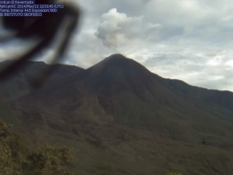
Had to add. This is totally self-indulgent. Off topic because it should be on Volcano Watch. But. In the past I have brought you photographic evidence that a giant fly was seen at Ubinas. Ubinas even had hair for a day. Now, I bring you a spider creeping up on an unsuspecting Reventor volcano.
I'm still trying to catch a ufo flying into the caldera. So far the lights have been streetlight reflections and the rays of the sun.
I'm sorry. I have not been commenting on Oklahoma on purpose. But my brain made a valid argument that needs expressing. If the USGS, and the (cough, gag, hack) the Oklahoma Geological Whatever- run by Austin Holland- have enough data to issue a warning of a large, damaging earthquake, and if the USGS and Mr. Holland have agreed and think it's "LIKELY" that it's due to injection, then why is injection continuing? To go forward (hate that "going forward" cliche) as per normal means you except responsibily for the consequences. The governing bodies knew and know the risks, and did and do nothing to stop the "future" event from happening. A warning is not action. This is simple law 101. A stopping of the injection is action. It's not even the drillers fault. They got licences. It's the issuers of the licences, the state, and it's agencies, that are mandated to ensure public safety. If someone dies from a falling wall or chimney, then how can the state say they couldn't have known their was a danger. A lawyer can easily show that any death from an induced earthquake will lead to a finding of negligence and it will be a wrongful death. Meaning, preventable.
This is simply a claim for responsibility. As to why there is a difference in policy when compared to other states like Ohio, that's a whole other ball game and in Oklahoma, the regulators have their teeth knocked out.
How can you issue a warning, and then do nothing about the problem at the root of the issue? It's like trying get rid of dandelions by using a leaf blower.
Oh, I looked at the Okie seismos and there's an earthquake. What a surprise? There's no point in commenting on any one earthquake in Oklahoma, because it's constant. Four minutes ago, there was an earthquake in Oklahoma. And, I'm sure within the next couple hours, there'll be another. The question is when is the big one the next squiggly line I see? I believe the drillers are trying to keep the earthquakes to a minimum. This means they are running around the whole state and dumping everywhere. As soon as a well starts hitting the 3+ range, I bet they then pause or move on to the next well. They wait for the water to be "absorbed", and then come back.
This is an experiment. No where, at any time, as injection gone on at this scale. Other states are doing the same thing. But in Oklahoma, they are at "near full production". This makes me wonder about the entire state. At this point my imagination runs wild. Because what is happening under the state is pushing us (humanity) into the unknown. How much stress can the layer of rock take?
When you start to think about it, you can get lost in the technicalities. But there's the problem. Here's one fact. The geologists that are pumping the water into the layer of rock, do not know exactly what happens exactly. I'm sure they have a good understand of the general principles. But there's no way to know what's happening within the rock because it's physically impossible to observe it directly. They only have models. And models aren't exactly what's happening way under the ground. The geologists are on top observing with instruments. There is a limit to what they can know. Meaning. They are risking public safety based on their best guesses and they are continuing to change the landscape (both terrestrial and subterranean) on a epic scale. The consequences will also be epic.
(imagine if all the state went off in a way comparable to the New Madrid in 1811-1812. ) (the rest of my imaginings are too sci-fi too relay here.)
There will be a 8 + in Alaska soon. But I can't decide where. Alaska is a big place. And my son insists it should be part of Canada and not the United States. The thing that has me wondering about Alaska is that the far north is active. We still are getting activity. If a large earthquake is due at a gap, then it will be in the middle of the arc. At the very tip of the actual mainland before the chain of volcanic islands. However, Juneau? Or, maybe near the northerly epicenter.
I think there will be a tsunami. Hopefully, if it's in a remote location, the damage may be ... I don't like speculating beyond this point. Because we now are too familiar with a tsunami's destructive power.
Had to add. This is totally self-indulgent. Off topic because it should be on Volcano Watch. But. In the past I have brought you photographic evidence that a giant fly was seen at Ubinas. Ubinas even had hair for a day. Now, I bring you a spider creeping up on an unsuspecting Reventor volcano.
I'm still trying to catch a ufo flying into the caldera. So far the lights have been streetlight reflections and the rays of the sun.
edit on 11-5-2014 by ericblair4891 because: (no reason given)
I'm sorry. I have not been commenting on Oklahoma on purpose. But my brain made a valid argument that needs expressing. If the USGS, and the (cough, gag, hack) the Oklahoma Geological Whatever- run by Austin Holland- have enough data to issue a warning of a large, damaging earthquake, and if the USGS and Mr. Holland have agreed and think it's "LIKELY" that it's due to injection, then why is injection continuing? To go forward (hate that "going forward" cliche) as per normal means you except responsibily for the consequences. The governing bodies knew and know the risks, and did and do nothing to stop the "future" event from happening. A warning is not action. This is simple law 101. A stopping of the injection is action. It's not even the drillers fault. They got licences. It's the issuers of the licences, the state, and it's agencies, that are mandated to ensure public safety. If someone dies from a falling wall or chimney, then how can the state say they couldn't have known their was a danger. A lawyer can easily show that any death from an induced earthquake will lead to a finding of negligence and it will be a wrongful death. Meaning, preventable.
This is simply a claim for responsibility. As to why there is a difference in policy when compared to other states like Ohio, that's a whole other ball game and in Oklahoma, the regulators have their teeth knocked out.
How can you issue a warning, and then do nothing about the problem at the root of the issue? It's like trying get rid of dandelions by using a leaf blower.
edit on 11-5-2014 by ericblair4891 because: (no reason given)
edit on 11-5-2014 by ericblair4891 because: (no reason
given)
Oh, I looked at the Okie seismos and there's an earthquake. What a surprise? There's no point in commenting on any one earthquake in Oklahoma, because it's constant. Four minutes ago, there was an earthquake in Oklahoma. And, I'm sure within the next couple hours, there'll be another. The question is when is the big one the next squiggly line I see? I believe the drillers are trying to keep the earthquakes to a minimum. This means they are running around the whole state and dumping everywhere. As soon as a well starts hitting the 3+ range, I bet they then pause or move on to the next well. They wait for the water to be "absorbed", and then come back.
This is an experiment. No where, at any time, as injection gone on at this scale. Other states are doing the same thing. But in Oklahoma, they are at "near full production". This makes me wonder about the entire state. At this point my imagination runs wild. Because what is happening under the state is pushing us (humanity) into the unknown. How much stress can the layer of rock take?
When you start to think about it, you can get lost in the technicalities. But there's the problem. Here's one fact. The geologists that are pumping the water into the layer of rock, do not know exactly what happens exactly. I'm sure they have a good understand of the general principles. But there's no way to know what's happening within the rock because it's physically impossible to observe it directly. They only have models. And models aren't exactly what's happening way under the ground. The geologists are on top observing with instruments. There is a limit to what they can know. Meaning. They are risking public safety based on their best guesses and they are continuing to change the landscape (both terrestrial and subterranean) on a epic scale. The consequences will also be epic.
(imagine if all the state went off in a way comparable to the New Madrid in 1811-1812. ) (the rest of my imaginings are too sci-fi too relay here.)
edit on 11-5-2014 by ericblair4891 because: (no reason given)
a reply to: ericblair4891
Awesome post. I have been watching Ok with much interest. Shale fracking is a rather new thing in the upper ohio valley and the area around us. Ohio earthquakes woke them up a bit arround Youngstown and they made them reduce the injection pressure which decreased the amount of quakes .
On New Year’s Eve 2011, a 4.0 magnitude earthquake was recorded in Ohio. This and a series of other quakes in the region have been linked to a disposal well for injecting wastewater used in the fracking process by seismologists at Columbia University's Lamont-Doherty Earth Observatory. Wastewater from the fracking process is either recycled or trucked off site to be injected in a deep underground well. As the pressurized water is pushed below ground it can cause earthquakes on ancient faultlines. In response to the findings, the state is considering tougher rules on drilling. Governor John Kasich has been a strong proponent of fracking.
In January 2012, Ohio regulators asked D&L Energy, a company that carries out fracking near Youngstown, to stop re-injecting waste water from hydraulic fracturing while an investigation was opened up into the cause of 12 earthquakes in the area (including a 4.0-magnitude quake on New Year’s Eve)--an area not considered seismically active. The site is at the bottom of a 9,200-foot-deep injection disposal well. Geological experts say the reinjected brine water could find its way into subterranean faults and force parts of the planet to separate, causing tremors.[11] The earthquakes started in March 2011, about the same period that the major injection activities started.[12]
According to Michael C. Hansen, state geologist and coordinator of the Ohio Seismic Network, there is "little doubt" that the earthquake was related to injection wells. James Zehyringer, director of the Department of Natural Resources, announced that two 9,000-foot-deep injection wells in Youngstown Township owned by Northstar Disposal Services and operated by D&L Energy would be closed.[13]
On March 9, 2012, Ohio oil and gas regulators issued a preliminary report “on the relationship between the Northstar 1 Class II disposal well and 12 Youngstown area earthquakes.” The report found "a number of co-occurring circumstances strongly indicating the Youngstown area earthquakes were induced." In response, Ohio regulators said new safeguards would be added to Ohio’s existing disposal well regulatory framework, including prohibiting any new wells to be drilled into the Precambrian basement rock formation; mandating that operators submit extensive geological data before drilling; and implementing state-of-the-art pressure and volume monitoring devices including automatic shut-off switches and electronic data recorders.[14]
In 2013, the Journal of Geophysical Research paper, "Induced seismicity associated with fluid injection into a deep well in Youngstown, Ohio," concluded that "the recent earthquakes in Youngstown, Ohio were induced by the fluid injection at a deep injection" and that the data "may indicate that the earthquakes were directly caused by the pressure buildup and stopped when pressure dropped."[15]
In April 2014 a state investigation of five small tremors the previous month in the Youngstown area concluded a "probable" link between the tremors and fracking in the region, marking the first time tremors in the region were tied directly to the fracking process itself, rather than the injection of wastewater.[16] link for ohio fracking sourcewatch
the last statement above links quakes to fracking itself but the bulk have been linked to reinjection of brine and waste back into the ground. Now, not counting the quakes can it really be good to inject waste chemicals and salts into the ground we depend on for life and fresh water. I dont care how deep it is it will eventually make it to somewhere it is not wanted and will need to be delt with by following generations even if we do not have to deal with it ourselves. Are we introducing the start to a global crisis so a few of the PTB can make a few $$$$$. You better believe it! Just yet another example that the average joe has no rights that everything is controlled by big corporations and there paid off politicians.
Case in point: Wastewater
In February 2011, the NY Times reported that a never-released study by the EPA and a confidential study by the drilling industry concluded that radioactivity in drilling waste cannot be fully diluted in rivers and other waterways, yet federal and state regulators are allowing most sewage treatment plants that accept drilling waste not to test for radioactivity. In West Virginia, a plant in Wheeling discharged gas-drilling wastewater into the Ohio River. Pennsylvania has sent some of its fracking waste to West Virginia for disposal.[1]
The Times also reported that "a 1987 report to Congress by the Environmental Protection Agency that deals with waste from the exploration, development and production of oil, natural gas and geothermal energy ... states that hydraulic fracturing, also called fracking, can cause groundwater contamination. It cites as an example a case in which hydraulic fracturing fluids contaminated a water well in West Virginia. The report also describes the difficulties that sealed court settlements created for investigators." The report concluded that hydraulic fracturing fluids or gel used by Kaiser Exploration and Mining Company contaminated a well roughly 600 feet away on the property of James Parsons in Jackson County, West Virginia. The report contradicts prior statements by the oil and gas industry that there had never been a documented case of contamination, helping the industry avoid federal regulations.[2] link to wv fracking
Sorry i will get off my soapbox now.
Looks like a decent sized quake along the PNW...initial listing by USGS is
Mag 5.3 offshore Oregon. Probably strike-slip style faulting, based
on its location.
Strange timing...I had just been trying to find the listing for the smaller earthquake at 16:46 UTC today. It's still not listed, but you can see it on many of the PNSN spectrograms. Possibly a foreshock, yet no one would know because it never made it to USGS.
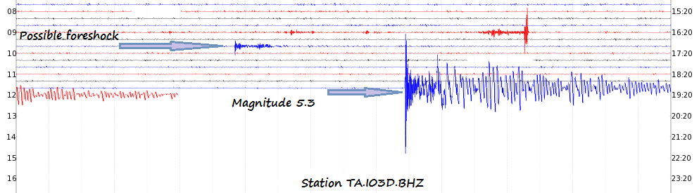
image source
%&&%&%%&%&%&%&%&%&
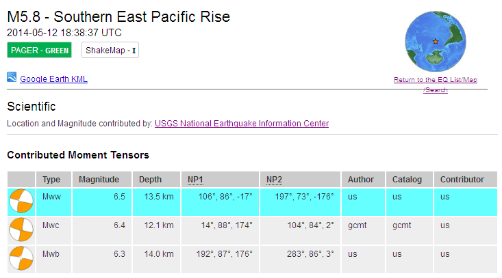
Magnitude 5.8 Southern East Pacific Rise USGS
Strange timing...I had just been trying to find the listing for the smaller earthquake at 16:46 UTC today. It's still not listed, but you can see it on many of the PNSN spectrograms. Possibly a foreshock, yet no one would know because it never made it to USGS.
edit on 5/12/2014 by Olivine because: add a thought
image source
edit on 5/12/2014 by Olivine because: add an image
%&&%&%%&%&%&%&%&%&
Magnitude 5.8 Southern East Pacific Rise USGS
edit on
5/12/2014 by Olivine because: add another EQ
M6.8 - 105km SE of Punta de Burica, Panama 2014-05-13 06:35:24 UTC
Looks like this one was felt almost 400 km away. I wonder how much further away it was felt?
Location
7.249°N 82.330°W depth=10.0km (6.2mi)
Looks like this one was felt almost 400 km away. I wonder how much further away it was felt?
One has to wonder why it is that USGS continue to do this so often. Posted as Magnitude 5.8 mb yet
the same as other providers in the moment tensors.
Screen shot of the page linked above
Click the image to enlarge
On both EMSC (Reviewed) and GFZ Potsdam (Automatic) as Magnitude 6.4 Mw
More details on my blog
Screen shot of the page linked above

Click the image to enlarge
On both EMSC (Reviewed) and GFZ Potsdam (Automatic) as Magnitude 6.4 Mw
More details on my blog
A comment upon the most excellent post by: Olivine
As so many do not. Many are called but few are chosen. Unfortunately this one did not manage to make the high standards required to be included in the catalogue of catalogues, "The True Picture of World Seismicity Not"
yet no one would know because it never made it to USGS.
As so many do not. Many are called but few are chosen. Unfortunately this one did not manage to make the high standards required to be included in the catalogue of catalogues, "The True Picture of World Seismicity Not"
a reply to: batcrapcrazy
I really think it is about time we stopped these seismologists from doing this. Just because they are seismologists does not mean they can go round causing quakes by injecting their fracking waste water.
This and a series of other quakes in the region have been linked to a disposal well for injecting wastewater used in the fracking process by seismologists at Columbia University's Lamont-Doherty Earth Observatory.
I really think it is about time we stopped these seismologists from doing this. Just because they are seismologists does not mean they can go round causing quakes by injecting their fracking waste water.
M6.5 - 102km SE of Ifalik, Micronesia
Event Time
2014-05-14 20:56:17 UTC
2014-05-15 06:56:17 UTC+10:00 at epicenter
2014-05-14 15:56:17 UTC-05:00 system time
Location
6.600°N 145.100°E depth=16.0km (9.9mi)
Nearby Cities
102km (63mi) SE of Ifalik, Micronesia
733km (455mi) W of Weno, Micronesia
751km (467mi) W of Weno - Chuuk State Legislature, Micronesia
751km (467mi) W of Weno Town, Micronesia
761km (473mi) S of Hagatna, Guam
USGS
a reply to: Darkblade71
It appears that the EQ you listed at 20:56:17 UTC (revised downward by USGS to mag 6.1 mwb) on 14 May 2014, was a foreshock to this Mag 6.6 mwp (Moment Tensor of Mag 6.4 Mwc).
There was also a Mag 6.2 in the Phillippines a few hours ago:
*************************
It seems as if ABC7 realized many people loved their EQ drum, and they brought it back!
Here is the link to the QuakeCam
It appears that the EQ you listed at 20:56:17 UTC (revised downward by USGS to mag 6.1 mwb) on 14 May 2014, was a foreshock to this Mag 6.6 mwp (Moment Tensor of Mag 6.4 Mwc).
M 6.6 - 96km SSE of Ifalik, Micronesia
PAGER - GREENShakeMap - VDYFI? - I
Time
2014-05-15 08:16:34 UTC
Location
6.509°N 144.899°E
Depth
10.0km
There was also a Mag 6.2 in the Phillippines a few hours ago:
M 6.2 - 50km WSW of Alim, Philippines
PAGER - GREENShakeMap - VDYFI? - I
Time
2014-05-15 10:16:41 UTC
Location
9.376°N 122.068°E
Depth
14.0km
*************************
It seems as if ABC7 realized many people loved their EQ drum, and they brought it back!
ABC7 Moderator Mod • 16 hours ago
UPDATE: We heard you loud and clear and we worked quickly to restore the live Quake Cam. We're thrilled to be able to tell you that you can now watch it live 24/7 here: abc7.com...
Here is the link to the QuakeCam
Party in the Leewards today
M6.0 - 128km NE of Grande Anse, Guadeloupe 2014-05-16 11:01:45 UTC
M6.0 - 128km NE of Grande Anse, Guadeloupe 2014-05-16 11:01:45 UTC
Location
17.100°N 60.200°W depth=37.0km (23.0mi)
Possible Mag 6 Leeward ISlands about 560 km from Kick'em Jenny which has recently been the subject of a paper on whether an eruption there could
cause a tsunami on the US American coast. Stupid scientists! It is much closer to South America.
a reply to: PuterMan
I know hobbyists aren't fans of the USGS, but old habits die hard! I've been trying to switch over to the EMSC as the listing source, but I often forget and revert to the USGS.
Anyway, USGS puts the first aftershock at a M5.0 while the EMSC put the main at a mb 5.8 and the first aftershock at a mb 5.0.
M 6.2 - Off the west coast of northern Sumatra
Time
2014-05-17 20:02:29 UTC-05:00
Location
4.259°N 92.747°E
Depth
9.8km
Hope your weekend has been good.
Time
2014-05-17 20:02:29 UTC-05:00
Location
4.259°N 92.747°E
Depth
9.8km
Hope your weekend has been good.
a reply to: wasobservingquietly
Interesting that in that article they say one of the problems is lack of offshore undersea seismographs.
Well GNS, with the help of USGS and I think it was GFZ, have recently installed a new set of undersea seismographs offshore Gisborne on the East Coast of the North Island.
It will be interesting to see if there is an uptick of events there (because of the new siesmos). The area is historically been the scene of slow slip earthquakes, and a M6.8 in 2008.
This has always been the argument /cause of increased earthquake activity worldwide since the 1940's ( more seismos)
Should be home soon, I will be 20 days behind by then in my NZ Earthquakes Archiving!
edit on 05u13813814 by muzzy because: (no reason given)
edit on 05u13813814 by muzzy because: (no reason given)
a reply to: wasobservingquietly
Thanks for posting this WOQ. Emily Brodsky is one of my favorite researchers. Her work on the nature of friction is really interesting; it's the least understood component of earthquake ruptures.
Here is a link to the Thorne Lay, et al paper discussing the Mag 8.1 Mw Iquique earthquake on 1 April 2014.
Through back-projections and deep water tsunami readings, they conclude that the EQ slip movement was large (between 2 and 6.7 meters) but only occurred over a small area of the thrust fault plane, and it did not rupture up-dip all the way to the trench.
That means that the 100+ year "seismic gap" area surrounding Iquique still has more slipping to do...specifically the area between 20.5°S, down to 23°S latitude, has enough accumulated stress to generate a Mag 8.5 Mw. Although that stretch could relieve the stress in a series of smaller quakes, instead of all at once.
edit on 5/19/2014 by Olivine because: wrong date
edit on 5/19/2014 by Olivine because: more detail
new topics
-
BIDEN Admin Begins Planning For January 2025 Transition to a New President - Today is 4.26.2024.
2024 Elections: 19 minutes ago -
Big Storms
Fragile Earth: 1 hours ago -
Where should Trump hold his next rally
2024 Elections: 4 hours ago -
Shocking Number of Voters are Open to Committing Election Fraud
US Political Madness: 5 hours ago -
Gov Kristi Noem Shot and Killed "Less Than Worthless Dog" and a 'Smelly Goat
2024 Elections: 5 hours ago -
Falkville Robot-Man
Aliens and UFOs: 6 hours ago -
James O’Keefe: I have evidence that exposes the CIA, and it’s on camera.
Whistle Blowers and Leaked Documents: 6 hours ago -
Australian PM says the quiet part out loud - "free speech is a threat to democratic dicourse"...?!
New World Order: 7 hours ago -
Ireland VS Globalists
Social Issues and Civil Unrest: 8 hours ago -
Biden "Happy To Debate Trump"
2024 Elections: 8 hours ago
top topics
-
James O’Keefe: I have evidence that exposes the CIA, and it’s on camera.
Whistle Blowers and Leaked Documents: 6 hours ago, 13 flags -
Blast from the past: ATS Review Podcast, 2006: With All Three Amigos
Member PODcasts: 10 hours ago, 13 flags -
Australian PM says the quiet part out loud - "free speech is a threat to democratic dicourse"...?!
New World Order: 7 hours ago, 12 flags -
Biden "Happy To Debate Trump"
2024 Elections: 8 hours ago, 12 flags -
Mike Pinder The Moody Blues R.I.P.
Music: 11 hours ago, 8 flags -
What is the white pill?
Philosophy and Metaphysics: 10 hours ago, 6 flags -
Shocking Number of Voters are Open to Committing Election Fraud
US Political Madness: 5 hours ago, 6 flags -
RAAF airbase in Roswell, New Mexico is on fire
Aliens and UFOs: 8 hours ago, 5 flags -
Ireland VS Globalists
Social Issues and Civil Unrest: 8 hours ago, 5 flags -
Where should Trump hold his next rally
2024 Elections: 4 hours ago, 4 flags
active topics
-
Krystalnacht on today's most elite Universities?
Social Issues and Civil Unrest • 12 • : TheSingleBillie -
Gaza Terrorists Attack US Humanitarian Pier During Construction
Middle East Issues • 90 • : Zanti Misfit -
Gov Kristi Noem Shot and Killed "Less Than Worthless Dog" and a 'Smelly Goat
2024 Elections • 39 • : Zanti Misfit -
So this is what Hamas considers 'freedom fighting' ...
War On Terrorism • 268 • : TheWoker -
BIDEN Admin Begins Planning For January 2025 Transition to a New President - Today is 4.26.2024.
2024 Elections • 2 • : NoCorruptionAllowed -
Falkville Robot-Man
Aliens and UFOs • 7 • : KKLOCO -
Big Storms
Fragile Earth • 9 • : nerbot -
"We're All Hamas" Heard at Columbia University Protests
Social Issues and Civil Unrest • 294 • : TheWoker -
Where should Trump hold his next rally
2024 Elections • 15 • : Zanti Misfit -
Post A Funny (T&C Friendly) Pic Part IV: The LOL awakens!
General Chit Chat • 7138 • : baddmove