It looks like you're using an Ad Blocker.
Please white-list or disable AboveTopSecret.com in your ad-blocking tool.
Thank you.
Some features of ATS will be disabled while you continue to use an ad-blocker.

Quake Watch 2014
page: 62share:
a reply to: Olivine
Thanks for the link! An interesting read!
Although some of it is waaay over my head!
Oh, who am I kidding??? A lot of it is!!!
Love the graphs & figures. I'm a visual learner.
One thing that was mentioned was water density variation.
Something I hadn't thought about in a long time!
I still have a lot of learning to do!
I wish they would have had present day monitoring equipment back in 1960.
I would have loved to be able to see the stats from their big one.
Watching Japan's develop was mesmerizing!
Although I hope they never have another one that big!
WOQ
I'm back in Kapitistan! And back on Broadband!!
Really missed being able to surf the Net for earthquake info. Lots of catching up to do
this article is interesting;
info.geonet.org.nz...
 (click image for larger version, opens in new
tab/window)
(click image for larger version, opens in new
tab/window)
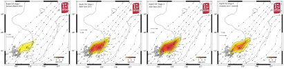
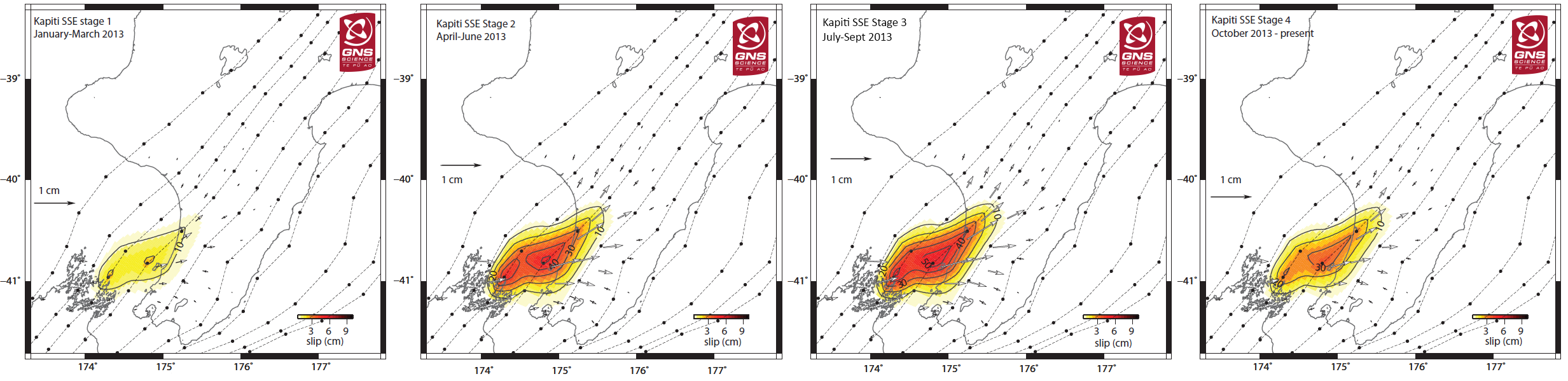
So this was going on before the Cook Strait M6's series and was most intense during that July/August period then easing off, so had to be part of it, although they don't mention that.
Really a good article, worth a full read, discusses the relationship between the Kapiti slow slip and the Jan 2014 Eketahuna M6
Really missed being able to surf the Net for earthquake info. Lots of catching up to do
this article is interesting;
The largest slow-slip event ever recorded in New Zealand
The Kapiti event started in early 2013 and is still going on. It is New Zealand’s largest slow-slip event ever recorded, equivalent to a magnitude 7.1 earthquake. We have 12 years of records in this region, which show three Kapiti events, each occurring roughly every five years. So far, this current event has as much as 15cm of movement over an area approximately 100km by 200km. The previous event in 2008 was equivalent to a magnitude 7.0 earthquake, but the movement was more concentrated: 30cm of movement over a smaller area near Kapiti Island. The 2013 slow-slip event evolved over the course of the year, moving north-eastward towards the North Island, with movement diminishing in late 2013-early 2014.
info.geonet.org.nz...
 (click image for larger version, opens in new
tab/window)
(click image for larger version, opens in new
tab/window) So this was going on before the Cook Strait M6's series and was most intense during that July/August period then easing off, so had to be part of it, although they don't mention that.
edit on 0500000014014014 by muzzy because: double image mistake
Really a good article, worth a full read, discusses the relationship between the Kapiti slow slip and the Jan 2014 Eketahuna M6
The fault in the Eketahuna earthquake would most likely have ruptured in the near future, but the added stress may have caused it to rupture earlier.
Slow-slip events do not universally increase stress on surrounding faults, they also relieve stress in some areas, and therefore may postpone an earthquake in an area of decreased stress.
edit on 05u14014014 by muzzy because: (no reason given)
here is the article about the
Earthquake instruments to be put on the seafloor in poverty bay - 12/05/2014
I had heard it on Radio NZ last week.
and a Blog post about the trip cires.colorado.edu...
Earthquake instruments to be put on the seafloor in poverty bay - 12/05/2014
I had heard it on Radio NZ last week.
and a Blog post about the trip cires.colorado.edu...
edit on 05u14014014 by muzzy because: (no
reason given)
M6.0 -
275km SE of Paradip Garh, India
2014-05-21
16:21:54 UTC
Location
18.254°N 88.080°E depth=40.0km (24.8mi)
Nearby Cities
275km (171mi) SE of Paradip Garh, India
275km (171mi) SE of Konarka, India
290km (180mi) SE of Puri, India
295km (183mi) SE of Nimaparha, India
650km (404mi) SSW of Dhaka, Bangladesh
USGS
edit on 21-5-2014 by Darkblade71 because: (no reason
given)
Unusual location!
Useless have 6.0mwb
bound to come down
ha! Darkblade beat me to it (mine is GFZ estimate)
F-E Region: Bay of Bengal
Time: 2014-05-21 16:21:50.4 UTC
Magnitude: 5.5
Epicenter: 87.92°E 18.17°N
Depth: 10 km
Status: A - automatic
geofon.gfz-potsdam.de...
Useless have 6.0mwb
bound to come down
ha! Darkblade beat me to it (mine is GFZ estimate)
edit on 05u14014014 by muzzy because: (no reason given)
16 day New Zealand update summary
muzzys rule running at 50/50 for May, energy released on the 8th UTC fell to 9TTNT but didn't result in a M5, but the Kermadecs did have a M4.6 and a M4.9 on the 12th UTC and 2 more M4's on the 13th UTC
The 17th UTC fell to 2TTNT and with no mucking about there was a M5.3 the next day South of the Kermadecs
Others;
Eketahuna 4 months on from the M6.3 is down to M1's and the odd M2, except for a 4.25ML on the 16th UTC
Cook Strait 10 months on from the 2 x M6's is still spitting out about half a dozen M1 and M2's each 24hr period
Also on the 12th UTC (same day as the 4.6 and 4.9 Kerm quakes) there was a small swarm of 7 earthquakes on the western shores of Lake Rotomahana in the Waimangu Volcanic Valley, the biggest being 2,33ML map
And on the 15th UTC a 12 quake swarm in the Wairakei Geothermal area north of Taupo, 5 x M2's a 3.06Ml and 4 x m1's map
Also on the 15th an unusual 4.77ML quake off the West Coast of the North Island map (may be an error)
Not a heck of a lot happening down the West Coast of the South Island/ Fiordland on a daily basis, although cumulatively it is looking pretty normal, except on the 6th UTC an unusual line of 4 x M3's up through the region, Dusky Sound, Te Anau, Mt Aspiring, Jackson Bay map
Generally overall pretty quiet
Numbers and Energy Count Graph for NZ, May 2014
edit on
0500000014014014 by muzzy because: add graph link
a reply to: muzzy
Welcome back home, Muzzy.
The slow-slip link you gave is great. I'd rather experience a mag 7 over months, instead of seconds, anyday.
^^^^^^^^^^^^^^
This is how we do shallow magnitude 3.2 Mb earthquakes...east coast style:
lol, 877 "did you feel it reports".
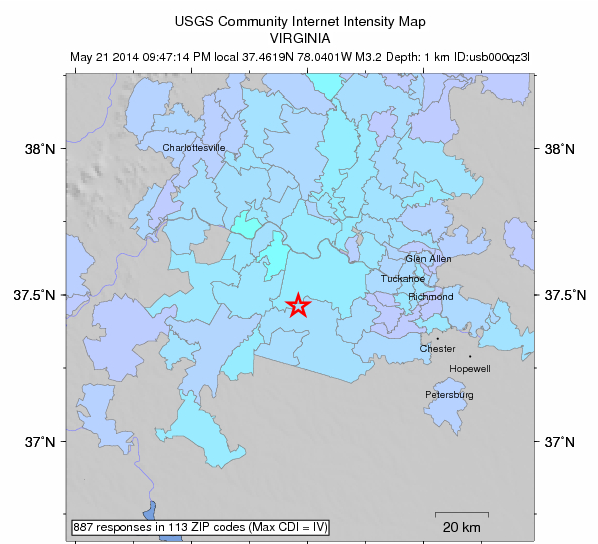
usgs
Here is a link to the nearest seismogram (vertical movement): TA.S58A..BHZ
I didn't feel this one, but my cat got right in my face and started yelling at me when it happened.
kitty.
Welcome back home, Muzzy.
The slow-slip link you gave is great. I'd rather experience a mag 7 over months, instead of seconds, anyday.
^^^^^^^^^^^^^^
This is how we do shallow magnitude 3.2 Mb earthquakes...east coast style:
lol, 877 "did you feel it reports".
usgs
Here is a link to the nearest seismogram (vertical movement): TA.S58A..BHZ
I didn't feel this one, but my cat got right in my face and started yelling at me when it happened.
kitty.
edit on 5/21/2014 by Olivine because: (no reason given)
Was just checking due to this thread, which may well be a hoax. www.abovetopsecret.com...
Is it just me or does Japan look very quiet at present.
P
Is it just me or does Japan look very quiet at present.
P
a reply to: pheonix358
Looks pretty normal, usually around 200 quakes per 24hr period, but the TTNT energy released is low, no big quakes
last M5 was on the 18th
Japan Preliminary data for 21/05/2014 15:03:00-22/05/2014 15:08:49UTC
mag1= 153 , mag2= 53 , mag3= 10
mag4= 0 , mag5= 0 , mag6= 0
total= 216 total energy released= 15.772 TTNT
map of 24hr period 22/05/2014 00:03:00JST to 23/05/2014 00:08:49JST (21/05/2014 15:03:00-22/05/2014 15:08:49UTC)
That Topic doesn't say what Time Zone, just 10:30am 21st May, I'll go take a look at both JST and UTC as it should be in the JMA Reviewed Data by now
edit on 05u14114114 by muzzy because: (no reason given)
a reply to: muzzy
interactive map of JMA reviewed earthquake data earthquake for Japan, 20052014-21052014JST which covers 10:30am 21st May in both JST and UTC, centered on Kume Island
No seismic activity, which discounts both volcanic and nuclear activity, even a big explosion, must be a fire
interactive map of JMA reviewed earthquake data earthquake for Japan, 20052014-21052014JST which covers 10:30am 21st May in both JST and UTC, centered on Kume Island
No seismic activity, which discounts both volcanic and nuclear activity, even a big explosion, must be a fire
a reply to: muzzy
Muzzys Rule back up to 66/33 for May
TTNT energy released on the 21st was down below 10, at 7 TTNT
BOOM
probably snowing there too, big old Winter cold front just sweeping the country tonight, 100km+ winds here in Cook Strait right now, Kuhurangi National Park in the South Island to the West of us getting hammered with heavy rain, expecting it here midnight through 3am
www.metservice.com...
Muzzys Rule back up to 66/33 for May
TTNT energy released on the 21st was down below 10, at 7 TTNT
BOOM
Public ID 2014p384573
Universal Time May 23 2014 at 7:00:34
NZ Standard Time Friday, May 23 2014 at 7:00:34 pm
Latitude, Longitude -45.61, 167.18
Focal Depth 81 km
Magnitude 5.1ML
Location 45 km west of Te Anau
www.geonet.org.nz...
probably snowing there too, big old Winter cold front just sweeping the country tonight, 100km+ winds here in Cook Strait right now, Kuhurangi National Park in the South Island to the West of us getting hammered with heavy rain, expecting it here midnight through 3am
www.metservice.com...
edit on 05u14214214 by muzzy because: (no reason given)
One thing I did get done when I was away and offline was to process some ANSS data I had downloaded prior to departure
Continental United States, Alaska, Puerto Rico and Hawaii maps updated February through to end of April 2014, just published now
Feb and March numbers quite high,
Feb 14% higher than average probably due to that Mammoth Lakes swarm
March 10% higher than average likely because of the offshore Eureka 6.8Mw aftershocks and the tail end of the Mammoth Lakes swarm
edit on
05u14214214 by muzzy because: (no reason given)
Incoming Mag 6.4 Aegean Sea
geofon.gfz-potsdam.de...
More details shortly
Location in Google Maps
Derived from Event Data Source: USGS
Powered by QVSData
F-E Region: Aegean Sea
Time: 2014-05-24 09:25:03.5 UTC
Magnitude: 6.4
Epicenter: 25.38°E 40.28°N
Depth: 10 km
Status: A - automatic
geofon.gfz-potsdam.de...
More details shortly
Magnitude 6.4 - Aegean Sea (365) [F]
Location in Google Maps
- Date-Time: Saturday, May 24, 2014 @ 09:25:03 UTC
- Earthquake location: 40.313°N, 25.453°E,
- Earthquake depth: 10.0 km
- Distances:
18km (11mi) S of Kamariotissa, Greece
69km (42mi) SSW of Alexandroupolis, Greece
78km (48mi) ESE of Potos (Thassos), Greece
83km (51mi) WNW of Canakkale, Turkey
299km (185mi) NNE of Athens, Greece
- Event ID: usb000r2hc
Derived from Event Data Source: USGS
Powered by QVSData
edit on
24/5/2014 by PuterMan because: (no reason given)
a reply to: PuterMan
Magnitude mb 6.5
Region AEGEAN SEA
Date time 2014-05-24 09:25:01.4 UTC
Location 40.27 N ; 25.36 E
Depth 2 km
Distances 257 km NW of İzmir, Turkey / pop: 2,500,603 / local time: 12:25:01.4 2014-05-24
90 km W of Çanakkale, Turkey / pop: 87,791 / local time: 12:25:01.4 2014-05-24
47 km W of Gökçeada, Turkey / pop: 7,822 / local time: 12:25:01.4 2014-05-24
25 km S of Kamariótissa / pop: 1,022 / local time: 12:25:00.0 2014-05-24
EMSC
That is a huge one. Felt all the way in Athens
ETA:
Magnitude Mw 6.9
Region AEGEAN SEA
Date time 2014-05-24 09:25:02.9 UTC
Location 40.29 N ; 25.40 E
Depth 27 km
Distances 257 km NW of İzmir, Turkey / pop: 2,500,603 / local time: 12:25:02.9 2014-05-24
87 km W of Çanakkale, Turkey / pop: 87,791 / local time: 12:25:02.9 2014-05-24
44 km W of Gökçeada, Turkey / pop: 7,822 / local time: 12:25:02.9 2014-05-24
22 km S of Kamariótissa / pop: 1,022 / local time: 12:25:00.0 2014-05-24
EMSC
edit on 24-5-2014 by Hellas because: (no reason given)

new topics
-
Supreme Court Oral Arguments 4.25.2024 - Are PRESIDENTS IMMUNE From Later Being Prosecuted.
Above Politics: 1 hours ago -
Krystalnacht on today's most elite Universities?
Social Issues and Civil Unrest: 1 hours ago -
Chris Christie Wishes Death Upon Trump and Ramaswamy
Politicians & People: 2 hours ago -
University of Texas Instantly Shuts Down Anti Israel Protests
Education and Media: 4 hours ago -
Any one suspicious of fever promotions events, major investor Goldman Sachs card only.
The Gray Area: 6 hours ago -
God's Righteousness is Greater than Our Wrath
Religion, Faith, And Theology: 10 hours ago
top topics
-
VP's Secret Service agent brawls with other agents at Andrews
Mainstream News: 15 hours ago, 11 flags -
Nearly 70% Of Americans Want Talks To End War In Ukraine
Political Issues: 16 hours ago, 6 flags -
Sunak spinning the sickness figures
Other Current Events: 15 hours ago, 5 flags -
Supreme Court Oral Arguments 4.25.2024 - Are PRESIDENTS IMMUNE From Later Being Prosecuted.
Above Politics: 1 hours ago, 4 flags -
Electrical tricks for saving money
Education and Media: 13 hours ago, 4 flags -
Krystalnacht on today's most elite Universities?
Social Issues and Civil Unrest: 1 hours ago, 4 flags -
Late Night with the Devil - a really good unusual modern horror film.
Movies: 17 hours ago, 3 flags -
Any one suspicious of fever promotions events, major investor Goldman Sachs card only.
The Gray Area: 6 hours ago, 2 flags -
University of Texas Instantly Shuts Down Anti Israel Protests
Education and Media: 4 hours ago, 2 flags -
Chris Christie Wishes Death Upon Trump and Ramaswamy
Politicians & People: 2 hours ago, 1 flags
active topics
-
Supreme Court Oral Arguments 4.25.2024 - Are PRESIDENTS IMMUNE From Later Being Prosecuted.
Above Politics • 6 • : TzarChasm -
University of Texas Instantly Shuts Down Anti Israel Protests
Education and Media • 92 • : FlyersFan -
President BIDEN Vows to Make Americans Pay More Federal Taxes in 2025 - Political Suicide.
2024 Elections • 143 • : SchrodingersRat -
SETI chief says US has no evidence for alien technology. 'And we never have'
Aliens and UFOs • 65 • : andy06shake -
Sunak spinning the sickness figures
Other Current Events • 18 • : andy06shake -
British TV Presenter Refuses To Use Guest's Preferred Pronouns
Education and Media • 155 • : Annee -
Nearly 70% Of Americans Want Talks To End War In Ukraine
Political Issues • 76 • : FlyersFan -
The Reality of the Laser
Military Projects • 49 • : 5thHead -
Chris Christie Wishes Death Upon Trump and Ramaswamy
Politicians & People • 6 • : mysterioustranger -
"We're All Hamas" Heard at Columbia University Protests
Social Issues and Civil Unrest • 282 • : 5thHead