It looks like you're using an Ad Blocker.
Please white-list or disable AboveTopSecret.com in your ad-blocking tool.
Thank you.
Some features of ATS will be disabled while you continue to use an ad-blocker.

Martian Ventifacts or Martian Artifacts? What's Your Take on This?
page: 1share:
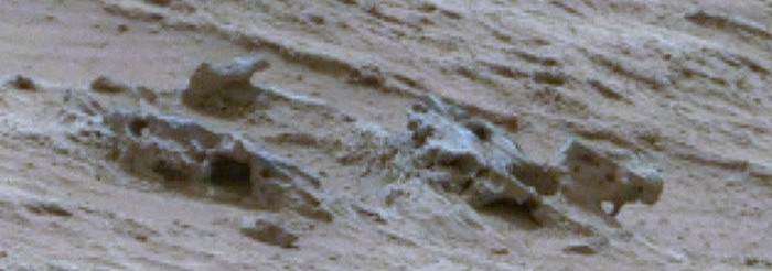
So here goes the next part of our Glenelg/Rocknest exploration program!
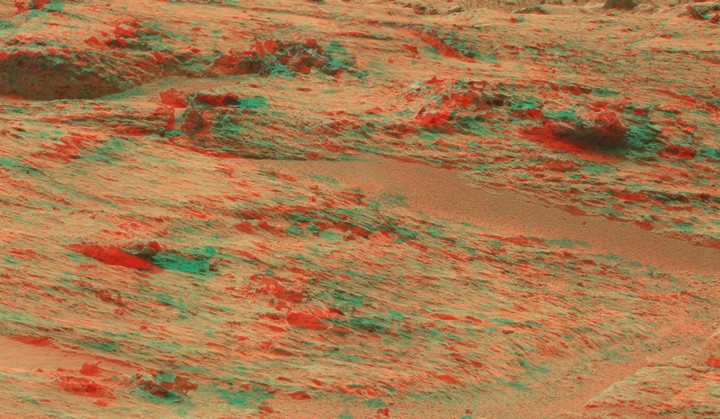
If possible, go and get yourself a pair of 3D anaglyphs (red/cyan) and take a look at the image below. It's a cropped section of a Sol 107 panorama I found on UMSF. I selected this special area, because it shows a whole variety of interesting shapes and there's no need to scroll around in a giant panorama. Please use the large version of the image and go fullscreen, if you can. You may need to focus your eyes slightly inwards and find the right distance from the screen.
In case you don't have 3D anaglyphs, you can also look at the normal images further below but you'll miss the additional depth (which is helpful for seeing the extraordinary geometry and symmetry displayed by these ventifacts/artifacts).
Preview 3D (anaglyph):
 Click here for the FULL SCREEN Version (3D anaglyph)
----------------------------------------------------------------
Preview (normal):
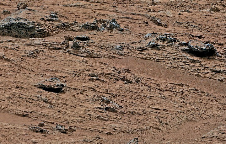 Click here for the 'normal' FULL SCREEN Version
(contrast-enhanced & color-balanced)
Click here for the 'normal' FULL SCREEN Version
(contrast-enhanced & color-balanced)
The original images can be found in the MSL Mastcam archive for Sol 107.
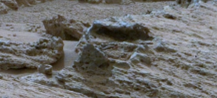
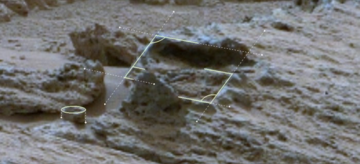
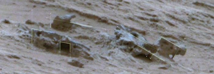
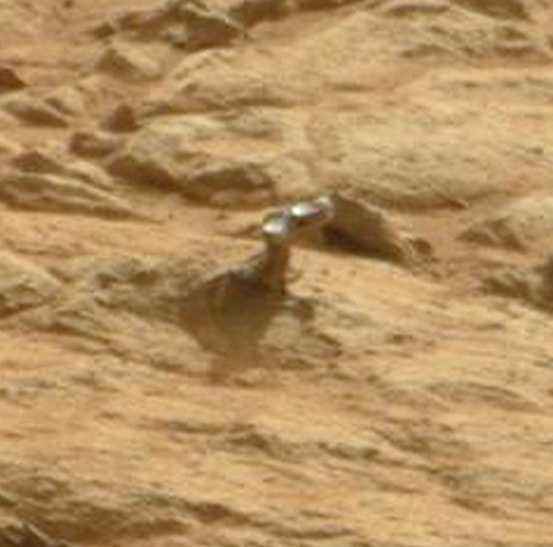
Based on the image above, I selected a few features that I found interesting in terms of their geometry and symmetry. For each excerpt, I added an overlay indicating the planes in which the ventifacts/artifacts lie. I also highlighted some noteworthy right angles that caught my attention. These indications may also be useful in case you didn't notice anything unusual at first glance. (Note: I used solid lines where a shape or geometrical detail is actually visible in the terrain, whereas the dotted lines are just for the purpose of guidance/orientation ... arcs indicate a clearly visible 90° angle).
Feature 1 (slightly above center, to the left)
----------------------------------------------------------------
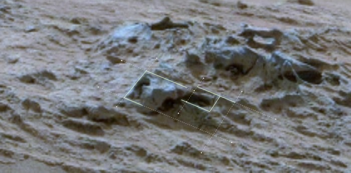
Feature 2 (bottom left of image)
----------------------------------------------------------------
Feature 3 (slightly above center to the right)

----------------------------------------------------------------
Feature 4 (top of image, slightly left of center)

What do you think? Are those features rather ventifacts (created by a special kind of wind erosion) or are we perhaps dealing with some kind of artifacts encased in rock? Something that had been manufactured and eroded down to this state over the aeons, without completely corroding & oxidizing away (perhaps it had been buried & resurfaced in some way, involving some kind of petrification or stone coating)?
It's a completely open question and there's no preferred answer, really. I'm just curious and keep asking myself how to interpret what I see ... would be great to have some opinions on this! Thanks in advance!
----------
Previous threads & posts (just in case you're interested):
- Some more 'intriguing' MSL images & 2 Opportunity pics that got me thinking!
- Curiosity "Thought-Experiment" & Image Compilation
- Potential 'Artifacts' discussed in a Video
- Discussion of the Rocknest Panorama
- Strange Shipwreck-Like Feature
- Strange Rocks Post 1, Post 2 and Post 3
If possible, go and get yourself a pair of 3D anaglyphs (red/cyan) and take a look at the image below. It's a cropped section of a Sol 107 panorama I found on UMSF. I selected this special area, because it shows a whole variety of interesting shapes and there's no need to scroll around in a giant panorama. Please use the large version of the image and go fullscreen, if you can. You may need to focus your eyes slightly inwards and find the right distance from the screen.
In case you don't have 3D anaglyphs, you can also look at the normal images further below but you'll miss the additional depth (which is helpful for seeing the extraordinary geometry and symmetry displayed by these ventifacts/artifacts).
Preview 3D (anaglyph):
----------------------------------------------------------------
Preview (normal):
The original images can be found in the MSL Mastcam archive for Sol 107.
Based on the image above, I selected a few features that I found interesting in terms of their geometry and symmetry. For each excerpt, I added an overlay indicating the planes in which the ventifacts/artifacts lie. I also highlighted some noteworthy right angles that caught my attention. These indications may also be useful in case you didn't notice anything unusual at first glance. (Note: I used solid lines where a shape or geometrical detail is actually visible in the terrain, whereas the dotted lines are just for the purpose of guidance/orientation ... arcs indicate a clearly visible 90° angle).
Feature 1 (slightly above center, to the left)
----------------------------------------------------------------
Feature 2 (bottom left of image)
----------------------------------------------------------------
Feature 3 (slightly above center to the right)
----------------------------------------------------------------
Feature 4 (top of image, slightly left of center)
What do you think? Are those features rather ventifacts (created by a special kind of wind erosion) or are we perhaps dealing with some kind of artifacts encased in rock? Something that had been manufactured and eroded down to this state over the aeons, without completely corroding & oxidizing away (perhaps it had been buried & resurfaced in some way, involving some kind of petrification or stone coating)?
It's a completely open question and there's no preferred answer, really. I'm just curious and keep asking myself how to interpret what I see ... would be great to have some opinions on this! Thanks in advance!
----------
Previous threads & posts (just in case you're interested):
- Some more 'intriguing' MSL images & 2 Opportunity pics that got me thinking!
- Curiosity "Thought-Experiment" & Image Compilation
- Potential 'Artifacts' discussed in a Video
- Discussion of the Rocknest Panorama
- Strange Shipwreck-Like Feature
- Strange Rocks Post 1, Post 2 and Post 3
Although some of them seem wind-aided others look something like the "spine" Arken found. Nice hunting. I'm more and more convinced that there are no
rocks on Mars, just billions of bones, lizards, metal shards and the occasional artwork,
The squarea you outlined seem, square. Is that a photographic artifact of missing pixels in feature two, or a real square hole? Thanks for the thread, very well put together.
The squarea you outlined seem, square. Is that a photographic artifact of missing pixels in feature two, or a real square hole? Thanks for the thread, very well put together.
edit on 19-3-2013 by Aleister because: (no reason given)
edit on 19-3-2013 by Aleister because: (no
reason given)
edit on 19-3-2013 by Aleister because: spelling
Originally posted by Submarines
Way too much time on your hands.
They are just rocks.
Maybe just rocks, yet very interestingly shaped and squared rocks. I for two want to encourage everybody who's looking at these pictures in search of oddities and the occasional very oddity, because if something eventually finds its way into the history book (are there history "books" anymore?) it will come from people who love to spend the time they have on their hands doing this - and more power to them. (what an odd expression, "time on your hands". When I see time on my hands I usually wash them, at least enough to get those irritating seconds off.).
edit on 19-3-2013 by Aleister
because: (no reason given)
The only thing that looks promising is the cylinder shape rock , but that can form naturally.
The 5th and 6th pics look like stamped or machined parts of something.We do see a lot of pics that are just rocks combined with wishful thinking, but
those looked made.
ETA- Just to clarify, the object on the right
ETA- Just to clarify, the object on the right
edit on 19-3-2013 by DAVID64 because: 'cause apparently i can't count
They are probably ventifacts, but there's no way of really knowing.
One think to take into consideration is perspective, some things may look like 90º angles only because of perspective, so those lines should be applied to both the images from the right and the left camera (I know, that's double the work). The advantage of doing this is that then we can make a 3D image of the ventifacts/artefacts and see if the shapes drawn over them are consistent with the perspective or not.
Another thing against these being some kind of artefacts is that I don't see any reason for them to keep some parts of their shapes intact and some parts broken or eroded, as an artefact would probably be made from a more consistent material than the (apparently) fragile sedimentary rocks that we can see on the photos from Mars.
Keep on looking.
PS: I prefer "cross-eye" versions of 3D images, as that way we are not depending on having the blue-red glasses and depending on those having the correct colours.
I didn't know the exact meaning of "ventifacts" although I guessed correctly. Here is the definition given by the learned professors at wikipedia,
and the page link.
en.wikipedia.org...
en.wikipedia.org...
Ventifacts are rocks that have been abraded, pitted, etched, grooved, or polished by wind-driven sand or ice crystals. These geomorphic features are most typically found in arid environments where there is little vegetation to interfere with aeolian particle transport, where there are frequently strong winds, and where there is a steady but not overwhelming supply of sand.
reply to post by Aleister
Go to Google images type ventifacts and you will see rocks on Earth that look like the ones on Mars ie organic shapes and regular shapes with straight edges like pyramids etc never assume what nature can and cannot do!!
Go to Google images type ventifacts and you will see rocks on Earth that look like the ones on Mars ie organic shapes and regular shapes with straight edges like pyramids etc never assume what nature can and cannot do!!
Originally posted by Submarines
Way too much time on your hands.
I take the time that's necessary because I feel it's important to highlight these things. And it's a great pleasure for me to present it to you and other members here on ATS
They are just rocks.
That's just one out of several possible conclusions!
Originally posted by Aleister
The squarea you outlined seem, square. Is that a photographic artifact of missing pixels in feature two, or a real square hole?
Thanks, Aleister.
As far as I can tell, that's got nothing to do with missing pixels. They seem to be crevices or holes in the 'rock'. Similar holes can also be seen on other formations, whereas the shape seems to be square-like, trapezoid-like or simply round, depending on the particular feature (and lighting, of course).
edit on 19-3-2013 by jeep3r because: text
Originally posted by ArMaP
One think to take into consideration is perspective, some things may look like 90º angles only because of perspective, so those lines should be applied to both the images from the right and the left camera (I know, that's double the work).
These views can be deceptive, no doubt. That's why I think the 3D anaglyph view is very helpful. With the additional depth we can better distinguish separate rocks (lying behind each other) from edges/features that form one distinct & coherent shape. Then the right angles also become more visible. But I guess we would actually need yet another perspective (and I'm not talking about the other stereo image) in order to be 100% sure about the 90° angles.
Another thing against these being some kind of artefacts is that I don't see any reason for them to keep some parts of their shapes intact and some parts broken or eroded, as an artefact would probably be made from a more consistent material than the (apparently) fragile sedimentary rocks that we can see on the photos from Mars.
I don't see any reason why their basic geometry should 'not' have been preserved while other features seem to have been damaged (to some extent) and partly went through different stages of erosion. Perhaps there was a 'sudden event' that caused these formations to be covered by layers of sand, rocks etc. while damages occured to different extents. But all that would be something for geologists to consider ... in case that would be a possible 'scenario'.
Keep on looking.
I definitely will
There's still a lot to say and show regarding Rocknest/Yellowknife Bay etc. I've actually identified all the 'hotspots' that I find interesting (up to Sol 200), so it's now just a matter of putting it all together to create these posts. I may have a bit less time in the next 2 weeks or so, but I'll keep working on it!
PS: I prefer "cross-eye" versions of 3D images, as that way we are not depending on having the blue-red glasses and depending on those having the correct colours.
I might implement those in future threads, but when you have lengthy structures/images you're somewhat limited in terms of resolution, especially in posts and threads, but we'll see. Apart from that, it can't be wrong to have a set of 3D anaglyphs in your drawer!
edit on 19-3-2013 by jeep3r because: text
Originally posted by jeep3r
I don't see any reason why their basic geometry should 'not' have been preserved while other features seem to have been damaged (to some extent) and partly went through different stages of erosion.
The problem I see with that is for that to happen then the artefacts should behave in the same way as the surrounding rocks, reacting to erosion in the same way.
For example, if a piece of metal is left on the surface and gets subjected to the same erosion as the surrounding rocks, do you think it will be affected in the same way?
As I don't see any clear evidence that these objects were affected in a different way I don't think they are made from a different material.
I might implement those in future threads, but when you have lengthy structures/images you're somewhat limited in terms of resolution, especially in posts and threads, but we'll see.
Yes, that's the problem with the "cross eye" method, it only works when things are close, it doesn't work in large images.
Apart from that, it can't be wrong to have a set of 3D anaglyphs in your drawer!
True, that's why I usually make three versions of every 3D image I make: a "cross-eye" stereogram, an anaglyph and an animated GIF.
Originally posted by ArMaP
They are probably ventifacts, but there's no way of really knowing.
the (apparently) fragile sedimentary rocks that we can see on the photos from Mars.
The fragilty of more than some of those rocks is something I have been harping on about. There is just not enough direct info in a dust covered piece of material to say sedimentary rock, or congealed sand that looks like a rock, albeit an odd looking rock, and is easily formed and reformed into all sorts of Contortions by weathering. But it is also someting of a contradiction, because it needs some moisture to congeal the sand, and there is evidence of dew on Mars easily explaining the 'sand castles' but not so easily explaining the fragile sedimentary rock that should be virtually dry of water.
reply to post by smurfy
Sedimentary rock was formed a long time ago, at a time where there was still water there.
As for dew, I haven't seen any signs of it on the rocks or on the ground.
Sedimentary rock was formed a long time ago, at a time where there was still water there.
As for dew, I haven't seen any signs of it on the rocks or on the ground.
Originally posted by ArMaP
reply to post by smurfy
Sedimentary rock was formed a long time ago, at a time where there was still water there.
As for dew, I haven't seen any signs of it on the rocks or on the ground.
Rocks including sedimentary can absorb moisture, or perhaps re-absorb periodically in the case of Mars in certain areas. This is the Phoenix lander's legs in the early morning,
Originally posted by smurfy
Rocks including sedimentary can absorb moisture, or perhaps re-absorb periodically in the case of Mars in certain areas. This is the Phoenix lander's legs in the early morning,
I know, that's why I said that I haven't seen any signs of moisture in the rocks or in the ground, because I have seen it on the photos from Phoenix.
I think that the lack of signs of moisture in the ground but visible on Phoenix (and, according to some people, on Curiosity's wheels) may be a result of different temperatures, as the metal from which the rovers and landers are made reacts to temperature in a different way, being a much better temperature conductor.
reply to post by jeep3r
Hey Jeep, very neat op. Congratulations.
Do you have a scale/size estimate for these artifacts?
Hey Jeep, very neat op. Congratulations.
Do you have a scale/size estimate for these artifacts?
Originally posted by ArMaP
I don't see any reason for them to keep some parts of their shapes intact and some parts broken or eroded (...)
If we consider for a moment that they actually 'were' artifacts, we may also need to ask: how did they get to their current and final location? Were they buried by layers of sand and rock? Were they under water? For how long? Was there freshwater or saltwater? Currents? What exactly were these features made of? Was there a subsequent and gradual uncovering of sand/rock layers over time? Or were they transported to their current location in a stream of mud and debris originating from the source of the alluvial fan?
I think that the above questions could shed light on why there are some irregular features sticking out of the rocks or why they look partially damaged.
(...) as an artefact would probably be made from a more consistent material than the (apparently) fragile sedimentary rocks that we can see on the photos from Mars.
That's what I would assume as well. On the other hand, I don't know just how fragile the sedimentary rocks are. But it seems that rocks of different consistency are scattered around in that area (see below).
The problem I see with that is for that to happen then the artefacts should behave in the same way as the surrounding rocks, reacting to erosion in the same way.
For example, if a piece of metal is left on the surface and gets subjected to the same erosion as the surrounding rocks, do you think it will be affected in the same way?
That's probably the most interesting aspect of it. One tends to think that they should react in the same way to erosion, yes. And the whole arrangement of rocks in that area does look somewhat uniform, although they seem to have a slightly different coloring than the surrounding rocks. But when looking at the 'Hugo' feature, erosion obviously can yield different results:
Here's what NASA/JPL wrote about that particular feature:
This knob has a different type of rock on the end of the projection. This rock may vary in composition or the rock grain size may be smaller. The rock on top of the projection is likely more resistant to wind erosion and protects the underlying rock from being eroded. The shiny surface suggests that this rock has a fine grain and is relatively hard. Hard, fine-grained rocks can be polished by the wind to form very smooth surfaces (...)
Link to the official NASA/JPL document (PDF) on 'ventifacts'.
Apart from that, the erosional effects would certainly depend on a number of things. For example, the inclination of the features and their position in the terrain, the grain size of aeolian particles (when it comes to wind erosion), atmospheric conditions, surrounding vegetation (if any), time etc.
As far as I'm concerned, I'm still baffled by the amount of geometrical features that is visible in such a small area. And they don't look like square basaltic rock pillars (like the Giant's Causeway that resulted from volcanic activities). To me they look more like coherent frames or beams that had intentionally been formed like that, but who can tell for sure. Ultimately, a lot of unknowns are involved into this and there's still a plethora of questions to be answered ...
edit on 20-3-2013 by jeep3r because:
text
reply to post by LordAdef
Thanks, LordAdef. I didn't have the time yet to look into the scale aspect of these formations. They are probably small, if not even very small.
Another problem with that is that we are lacking any good points of reference in order to determine the scale. I also think that the features are not large enough (or distinct enough) to be resolved on the HIRISE images provided by NASA/JPL.
new topics
-
Egypt to join South Africa genocide case at ICJ
Middle East Issues: 2 hours ago -
Kingdom of the Planet of the Apes
Movies: 5 hours ago -
Jean Michel and Brian May Live from Bratislava
General Chit Chat: 10 hours ago
top topics
-
Trump Record Breaking Campaign Rally 5/11 in New Jersey Draws 100,000 People
2024 Elections: 15 hours ago, 14 flags -
Biden Withholding Sensitive US Intelligence on Hamas Leaders From Israel
US Political Madness: 14 hours ago, 10 flags -
Anybody else go to the movie theater a lot? Have you noticed how dead they are?
General Chit Chat: 14 hours ago, 7 flags -
something falls in Canada
Aliens and UFOs: 15 hours ago, 5 flags -
Iranian Lawmaker Declares Iran Has Nuclear Weapons
Mainstream News: 12 hours ago, 5 flags -
Jean Michel and Brian May Live from Bratislava
General Chit Chat: 10 hours ago, 5 flags -
Egypt to join South Africa genocide case at ICJ
Middle East Issues: 2 hours ago, 2 flags -
Kingdom of the Planet of the Apes
Movies: 5 hours ago, 1 flags
active topics
-
Bibi’s Dilemma
Middle East Issues • 272 • : jofafot -
Mood Music Part VI
Music • 3177 • : Hellmutt -
Anybody else go to the movie theater a lot? Have you noticed how dead they are?
General Chit Chat • 20 • : 777Vader -
Is there a dependence on the number of children in the family and its well-being?
New World Order • 44 • : chr0naut -
Egypt to join South Africa genocide case at ICJ
Middle East Issues • 12 • : CriticalStinker -
-@TH3WH17ERABB17- -Q- ---TIME TO SHOW THE WORLD--- -Part- --44--
Dissecting Disinformation • 955 • : brewtiger123 -
Kingdom of the Planet of the Apes
Movies • 12 • : chr0naut -
Biden Withholding Sensitive US Intelligence on Hamas Leaders From Israel
US Political Madness • 52 • : 777Vader -
REAL ID now a reality
General Conspiracies • 51 • : TheMisguidedAngel -
A new Why Files How CRISPR and AI Destroy the World
Science & Technology • 19 • : charlest2