It looks like you're using an Ad Blocker.
Please white-list or disable AboveTopSecret.com in your ad-blocking tool.
Thank you.
Some features of ATS will be disabled while you continue to use an ad-blocker.

Curiosity: "Thought-Experiment", Image Compilation PLUS a few Perhaps 'Disturbing' Questions
page: 1share:
Most of you probably know by now just how much I'm fascinated by Curiosity's imagery of Gale Crater (especially that of Rocknest) and I thought
I'd give it another try to fight for your attention on this!
Actually, I'd like to propose a quick "thought-experiment" regarding some of the more compelling pics in that area.
THE EXPERIMENT
Below you will find a selection of images that apparently show rocks or rock formations that are (in some way) quite different from their surroundings. They have been debated in several posts and threads, because of their distinct nature. Now, imagine you were in command of Curiosity's every move, as part of the science team at JPL. Please look closely at those images again and ask yourself: would you decide to make Curiosity investigate one or more of these 'rocks' more in detail? Would you want to acquire close-up MAHLI images (or much better MastCam-views) of any of those features? If yes, which ones would justify a closer look and why? If no, what's the reason for not checking them in detail?
BACKGROUND:
I don't want to spoil the fun but guess what?! The public image archives of NASA/JPL (that allegedly contain all images) DON'T PROVIDE A SINGLE CLOSE-UP OF ANY OF THE IMAGES BELOW ... and I (personally) don't believe this is so because all these 'rocks' are so boring (geologically speaking) or have - accidentally - been 'overseen'.
The lack of close-up views is even more incredible when looking at the very first image. In a previous post of mine, I came to the conclusion that this particular 'rock formation' is located slightly to the east of what NASA calls 'Point Lake' (see here for an overview-map). And what's even more disturbing: Curiosity's traverse-path led directly through the area of this (at least to me) very, very interesting 'rock'. Curiosity was literally standing right next to it (as revealed by the rover-tracks imaged on Sol 157. Yet, for some reason, there's no close-up view available.
Obviously, nobody at NASA/JPL came up with the idea to use the MastCam or MAHLI instrument for closer inspection! Or they did. But in that case, NASA's so-called 'public archive' wouldn't be so transparent after all and rather serve as a platform for very selective publishing of acquired imagery. It's just a thought, but judge for yourself! I, for one, find this whole situation quite telling (and annoying)!
Apologies for the rant!
But again: please let me know what you would do if you could determine where Curiosity went and which close-ups were to be acquired. And in case these 'rocks' are not of any interest to you, please also let me/us know why?
Thanks!
------------
And here go the IMAGES (NOTE: Some pics have been contrast-enhanced and slightly sharpened. The original NASA/JPL images, however, are also linked below in case you prefer a direct comparison):
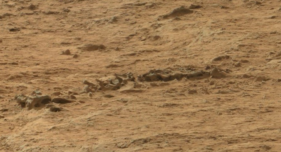
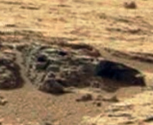
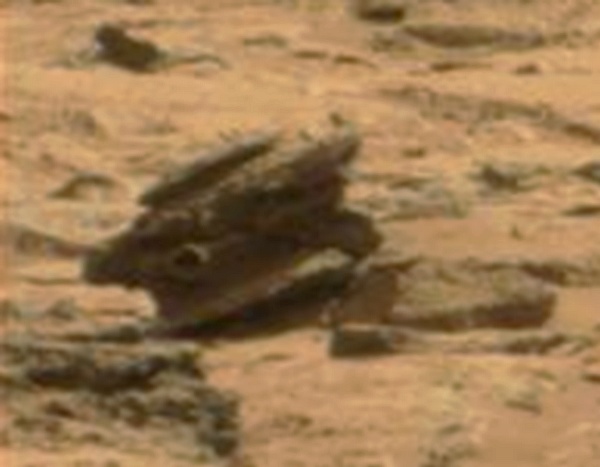
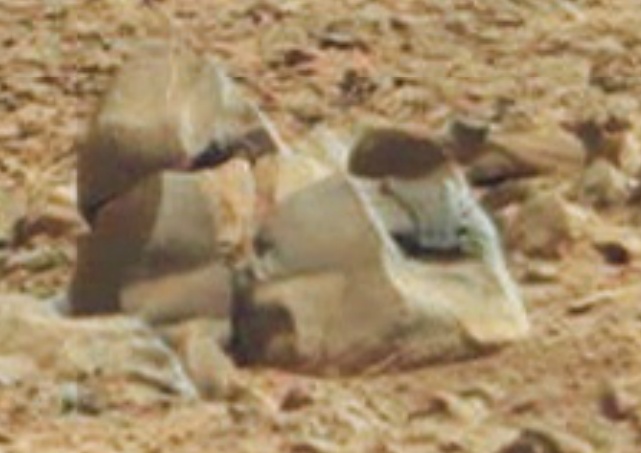
Image 1 ('The Boat')
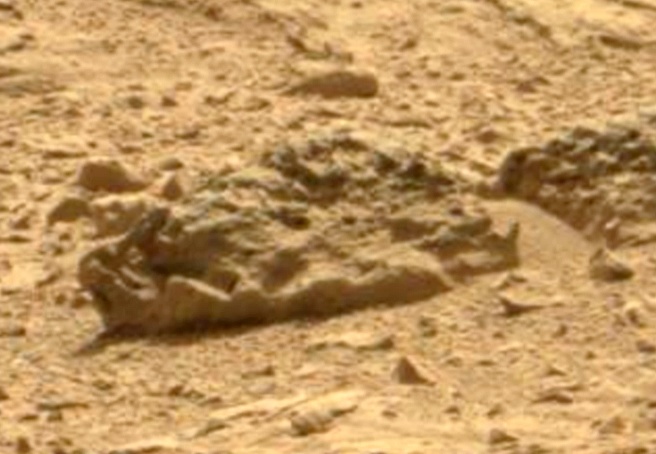
Same 'rock' in a larger context:
 Click here for the original NASA/JPL
Image
Click here for the original NASA/JPL
Image
------------
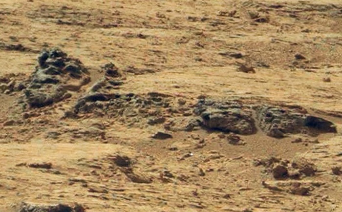
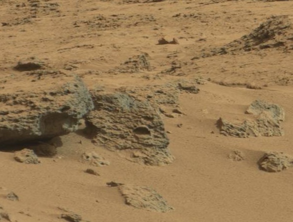
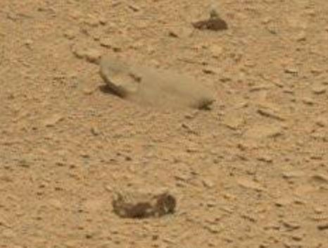
Image 2 ('The Shovel')
 Click here for the original NASA/JPL
Image
Click here for the original NASA/JPL
Image
------------
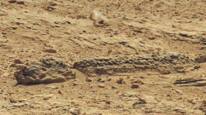
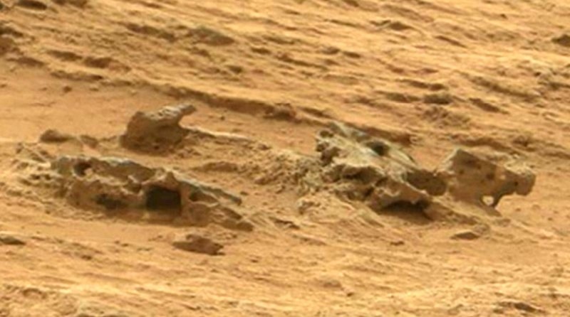
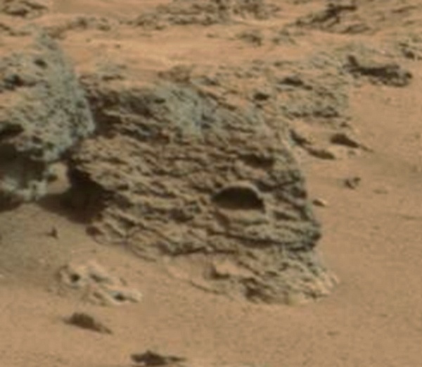
Image 3 ('The Fossil') -> discovered by ATS-Member Arken
Same 'formation' in a larger context:
 Click here for the original NASA/JPL
Image (Part A)
Click here for the original NASA/JPL
Image (Part A)
Click here for the original NASA/JPL Image (Part B)
------------
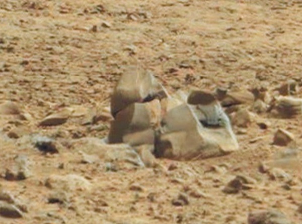
Image 4 ('The Scrap Plates')
 Click here for the original NASA/JPL
Image
Click here for the original NASA/JPL
Image
------------
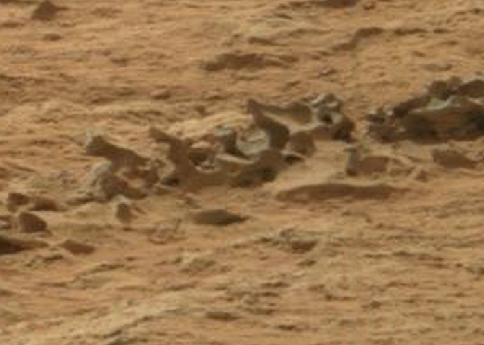
Image 5 ('The Cross-Section')
Formation in context:
Rocks on left side in close-up view:
Rocks on right side in close-up view:
 Click here for the original NASA/JPL
Image (Part A)
Click here for the original NASA/JPL
Image (Part A)
Click here for the original NASA/JPL Image (Part B)
------------
Image 6 'The Triangle' -> first spotted by ATS-Member Nerbot
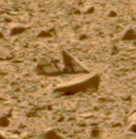
Same 'rock' in a larger context:
 Click here for the original NASA/JPL
Image
Click here for the original NASA/JPL
Image
------------
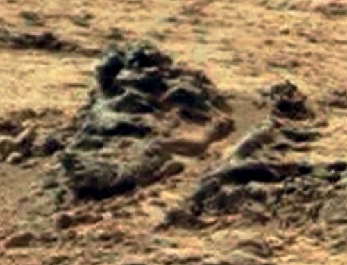
Image 7 'The Cauldron'
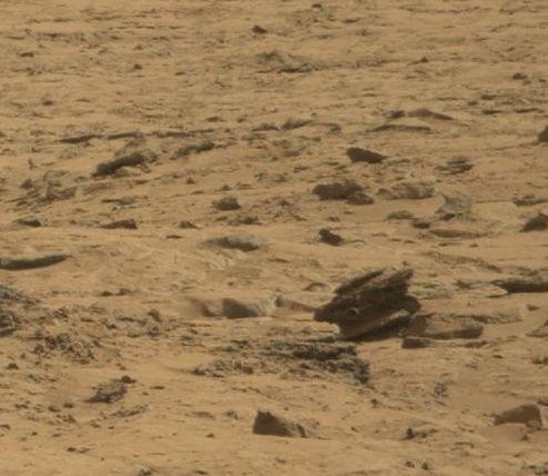
Close-Up View:
 Click here for the original NASA/JPL
Image
Click here for the original NASA/JPL
Image
------------
Image 8 'The Pipeline'
Close-Up View:
 Click here for the original NASA/JPL
Image
Click here for the original NASA/JPL
Image
------------
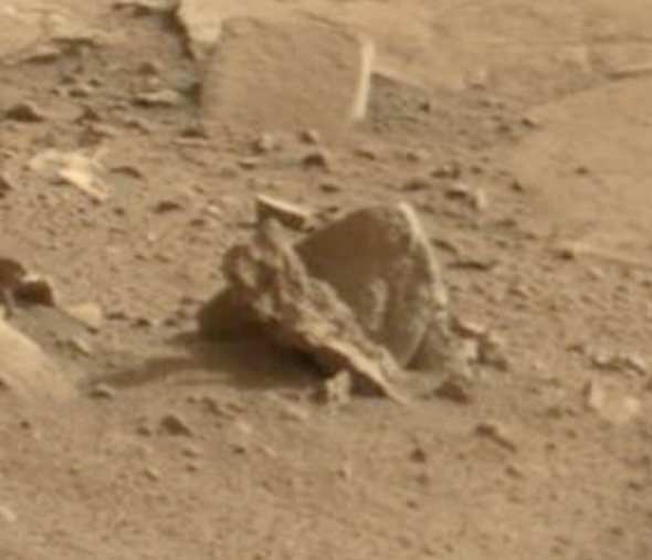
Image 9 'The Ornament' -> spotted by ATS-Member Bilk22
Close-Up View:
 Click here for the original NASA/JPL
Image
Click here for the original NASA/JPL
Image
------------
And, finally, here go my previous threads/posts which are more or less 'related' to the subject discussed above (just FYI):
- Potential 'Artifacts' discussed in a Video
- Discussion of the Rocknest Panorama
- Strange Shipwreck-Like Feature
- Strange Rocks Post 1
- Strange Rocks Post 2
- Strange Rocks Post 3
(Note: when clicking on 'posts', please wait until page has fully loaded and scrolled to post)
Actually, I'd like to propose a quick "thought-experiment" regarding some of the more compelling pics in that area.
THE EXPERIMENT
Below you will find a selection of images that apparently show rocks or rock formations that are (in some way) quite different from their surroundings. They have been debated in several posts and threads, because of their distinct nature. Now, imagine you were in command of Curiosity's every move, as part of the science team at JPL. Please look closely at those images again and ask yourself: would you decide to make Curiosity investigate one or more of these 'rocks' more in detail? Would you want to acquire close-up MAHLI images (or much better MastCam-views) of any of those features? If yes, which ones would justify a closer look and why? If no, what's the reason for not checking them in detail?
BACKGROUND:
I don't want to spoil the fun but guess what?! The public image archives of NASA/JPL (that allegedly contain all images) DON'T PROVIDE A SINGLE CLOSE-UP OF ANY OF THE IMAGES BELOW ... and I (personally) don't believe this is so because all these 'rocks' are so boring (geologically speaking) or have - accidentally - been 'overseen'.
The lack of close-up views is even more incredible when looking at the very first image. In a previous post of mine, I came to the conclusion that this particular 'rock formation' is located slightly to the east of what NASA calls 'Point Lake' (see here for an overview-map). And what's even more disturbing: Curiosity's traverse-path led directly through the area of this (at least to me) very, very interesting 'rock'. Curiosity was literally standing right next to it (as revealed by the rover-tracks imaged on Sol 157. Yet, for some reason, there's no close-up view available.
Obviously, nobody at NASA/JPL came up with the idea to use the MastCam or MAHLI instrument for closer inspection! Or they did. But in that case, NASA's so-called 'public archive' wouldn't be so transparent after all and rather serve as a platform for very selective publishing of acquired imagery. It's just a thought, but judge for yourself! I, for one, find this whole situation quite telling (and annoying)!
Apologies for the rant!
But again: please let me know what you would do if you could determine where Curiosity went and which close-ups were to be acquired. And in case these 'rocks' are not of any interest to you, please also let me/us know why?
Thanks!
------------
And here go the IMAGES (NOTE: Some pics have been contrast-enhanced and slightly sharpened. The original NASA/JPL images, however, are also linked below in case you prefer a direct comparison):
Image 1 ('The Boat')
Same 'rock' in a larger context:
------------
Image 2 ('The Shovel')
------------
Image 3 ('The Fossil') -> discovered by ATS-Member Arken
Same 'formation' in a larger context:
Click here for the original NASA/JPL Image (Part B)
------------
Image 4 ('The Scrap Plates')
------------
Image 5 ('The Cross-Section')
Formation in context:
Rocks on left side in close-up view:
Rocks on right side in close-up view:
Click here for the original NASA/JPL Image (Part B)
------------
Image 6 'The Triangle' -> first spotted by ATS-Member Nerbot
Same 'rock' in a larger context:
------------
Image 7 'The Cauldron'
Close-Up View:
------------
Image 8 'The Pipeline'
Close-Up View:
------------
Image 9 'The Ornament' -> spotted by ATS-Member Bilk22
Close-Up View:
------------
And, finally, here go my previous threads/posts which are more or less 'related' to the subject discussed above (just FYI):
- Potential 'Artifacts' discussed in a Video
- Discussion of the Rocknest Panorama
- Strange Shipwreck-Like Feature
- Strange Rocks Post 1
- Strange Rocks Post 2
- Strange Rocks Post 3
(Note: when clicking on 'posts', please wait until page has fully loaded and scrolled to post)
edit on 4-3-2013 by jeep3r because: removed color-tags
edit on 4-3-2013 by jeep3r because: text
edit on
4-3-2013 by jeep3r because: text
Originally posted by jeep3r
Now, imagine you were in command of Curiosity's every move, as part of the science team at JPL. Please look closely at those images again and ask yourself: would you decide to make Curiosity investigate one or more of these 'rocks' more in detail? Would you want to acquire close-up MAHLI images (or much better MastCam-views) of any of those features? If yes, which ones would justify a closer look and why? If no, what's the reason for not checking them in detail?
That depends, if I didn't had anything else to do may I would move Curiosity to study those rocks, but if I had a mission to accomplish and I didn't know if I had the time to do it I wouldn't bother with those rocks.
PS: as you noticed, the colour tags do not like 'apostrophes'.
Originally posted by ArMaP
That depends, if I didn't had anything else to do may I would move Curiosity to study those rocks, but if I had a mission to accomplish and I didn't know if I had the time to do it I wouldn't bother with those rocks.
I agree, ArMaP, at least 'in principle'!
But the point I'm making is that Curiosity ...
a) was very close to one or more of those rocks and yet didn't image them in detail
b) did tons of close-ups of other things, that are (at least to us) absolutely boring
So, doing science is key, no discussion about it and I would also get Curiosity down to Yellowknife Bay to drill and do all the analysis & data gathering as fast as possible. But still: why did Curiosity take the time for thousands of other images that are so obviously lacking any interesting features ...
P.S.: And I have learned: the color tags actually do work just fine!
Curiosity is almost like a very slow pic-upload 'naut (astro, cosmo, chinao) who has to decide which rock to pick up or turn over. In hindsight maybe
some people at NASA and JPL wish they had taken a closer look at the "fossil spine" that Arken found, or one or two of the other rocks people have
pointed out. And like many other people, I'm surprised at the low quality out-of-focus picture detail when you zoom in on these objects.
On a related topic, does anyone know if Curiosity's number one computer has been fixed or is the jury still out (out looking for fossils!) Thanks.
On a related topic, does anyone know if Curiosity's number one computer has been fixed or is the jury still out (out looking for fossils!) Thanks.
anyone who who doesn`t see anything unusual or interesting enough about those rocks to go take a closer look at them, shouldn`t be driving a mars
rover.
If you saw those rocks on a beach and weren`t the least big curious to take a closer look at them then you shouldn`t be driving a mars rover.
When we send rovers to uncharted and unexplored parts of the universe we need people driving them who have a natural curiousity to explore and examine things.
If we are going to stick to a pre planned exploration route and time table then we don`t need real people involved,just program the drone to follow a time table and a route. The whole point of having humans involved in exploring is to be able to make on the spot decisions and changes when something unexpected or unusual pops up.
analytical minded rocket scientist are the worst possible choice of people to have as explorers.let them do what they are best at, getting the ship or drone to it`s destination.once we have arrived their job is done and people with true explorer spirit should take over the exploring and discovery phase.
reply to post by jeep3r
You are right in one thing: they have turned back at least in one case (I don't remember what Sol it was), so it looks like they are not in a hurry to reach the mission target.
Also, an interesting thing about the publishing of the photos (and other data) on the Planetary Data System; they wrote this:
PDS
Why aren't the Mastcam, MAHLI and MARDI images published yet? And what are those documents awaiting clearance?
You are right in one thing: they have turned back at least in one case (I don't remember what Sol it was), so it looks like they are not in a hurry to reach the mission target.
Also, an interesting thing about the publishing of the photos (and other data) on the Planetary Data System; they wrote this:
Release 1 does not include data from the MAHLI, MARDI, or Mastcam instruments. These instrument teams have not yet delivered data products to PDS.
Some documents in the MSL archives are awaiting clearance by JPL Document Review and/or the JPL Import/Export Control Office. They will be posted online as soon as clearance has been received, and announced on this web site.
PDS
Why aren't the Mastcam, MAHLI and MARDI images published yet? And what are those documents awaiting clearance?
reply to post by Tardacus
I don't think there's a specific person that decides what the rover should or should not do, from what I have read the team decides what to do based on the photos taken the day before (or just some hours before).
But I may be wrong.
I don't think there's a specific person that decides what the rover should or should not do, from what I have read the team decides what to do based on the photos taken the day before (or just some hours before).
But I may be wrong.
Well, those are interesting images. But, since there are amazing similar formations naturally formed on earth the rational conclusion if on mars is to
do other tests and research instead?
Originally posted by ArMaP
Also, an interesting thing about the publishing of the photos (and other data) on the Planetary Data System; they wrote this:
Release 1 does not include data from the MAHLI, MARDI, or Mastcam instruments. These instrument teams have not yet delivered data products to PDS.
That could actually be the answer for a lot of our questions and doubts. Good find & thanks for bringing this to our attention, ArMaP.
Personally, I think that even 'if' rocket-scientists or rather 'analytical' people have a say on what Curiosity should do, they (too) would investigate - at least - some of those rocks to see if it's more than just erosional features. And if it's really just 'natural' it may still be interesting to study such rocks from a geological point of view, I guess ...
Originally posted by ArMaP
reply to post by jeep3r
You are right in one thing: they have turned back at least in one case (I don't remember what Sol it was), so it looks like they are not in a hurry to reach the mission target.
Also, an interesting thing about the publishing of the photos (and other data) on the Planetary Data System; they wrote this:
Release 1 does not include data from the MAHLI, MARDI, or Mastcam instruments. These instrument teams have not yet delivered data products to PDS.
Some documents in the MSL archives are awaiting clearance by JPL Document Review and/or the JPL Import/Export Control Office. They will be posted online as soon as clearance has been received, and announced on this web site.
PDS
Why aren't the Mastcam, MAHLI and MARDI images published yet? And what are those documents awaiting clearance?
It's likely most people here don't know about this data being held back from the public. Those are all important cameras, if I understand the post correctly, and may contain more images of the "spine", of "Hugo", and the other major features that have attracted people's attention here. ArMap, this data may be worth a thread by itself, so it can be more fully explored, please consider doing so. Thanks for this information.
edit on
4-3-2013 by Aleister because: (no reason given)
reply to post by Aleister
mars.jpl.nasa.gov...
The statement is about the PDS site.
It isn't, obviously we have been seeing data from those instruments, including the "bones" from the MastCam. Data from those instruments is available here:
It's likely most people here don't know about this data being held back from the public.
mars.jpl.nasa.gov...
The statement is about the PDS site.
edit on 3/4/2013 by Phage because: (no reason given)
reply to post by jeep3r
Hi Jeep, good thread again.
I don't see the point of not stoping by and checking things out through out the journey! And the spot is nearby the path anyway.. I would actually check the perfect round formation on the left top corner of your ship picture (yep, I followed your last threads). Did you noticed that? Check out the original from NASA.
Very intriguing photo collection by the ats team. I may join soon
edit on 4-3-2013 by LordAdef because: (no reason given)
reply to post by ArMaP
Hi Armap,
Good point. But... What's the point then? What if some are not natural? Would nasa just miss it for the journey sake? The fact is no one can affirm they are not. At least the area stands out with a group of curious objects (rocks or whatever).
Hi Armap,
Good point. But... What's the point then? What if some are not natural? Would nasa just miss it for the journey sake? The fact is no one can affirm they are not. At least the area stands out with a group of curious objects (rocks or whatever).
reply to post by jeep3r
Hi jeep3r. Good thread and very good questions that cast shadows on the purpose and goals of this Mission.
My opinion is that NASA/JPL science team don't post publicly the entire shots/photo/images that they acquire from the Rover.
NASA/JPL science team is not (of course) a bunch of idiots, but very skilled researchers and scientists, and they already know those anomalies. They Detect, Study and Hush... in the dark, because "the things" up there are worst than we can imagine.
Most of the images are clearly photoshoped and they use the "true/false" colors of Mars like professionals to hide..."something".
S&F.
Hi jeep3r. Good thread and very good questions that cast shadows on the purpose and goals of this Mission.
Obviously, nobody at NASA/JPL came up with the idea to use the MastCam or MAHLI instrument for closer inspection! Or they did. But in that case, NASA's so-called 'public archive' wouldn't be so transparent after all and rather serve as a platform for very selective publishing of acquired imagery. It's just a thought, but judge for yourself! I, for one, find this whole situation quite telling (and annoying)!
My opinion is that NASA/JPL science team don't post publicly the entire shots/photo/images that they acquire from the Rover.
NASA/JPL science team is not (of course) a bunch of idiots, but very skilled researchers and scientists, and they already know those anomalies. They Detect, Study and Hush... in the dark, because "the things" up there are worst than we can imagine.
Most of the images are clearly photoshoped and they use the "true/false" colors of Mars like professionals to hide..."something".
S&F.
Originally posted by Arken
Most of the images are clearly photoshoped and they use the "true/false" colors of Mars like professionals to hide..."something".
If the images were photoshoped nobody would notice it, and colours are irrelevant.
Originally posted by ArMaP
Originally posted by Arken
Most of the images are clearly photoshoped and they use the "true/false" colors of Mars like professionals to hide..."something".
If the images were photoshoped nobody would notice it, and colours are irrelevant.
Not so sure... "eraser tool" work at full power in NASA/JPL laboratories.
edit on 5-3-2013 by Arken because: (no reason given)
Originally posted by LordAdef
Hi Jeep, good thread again (...) I would actually check the perfect round formation on the left top corner of your ship picture (yep, I followed your last threads). Did you noticed that? Check out the original from NASA.
Thanks, LordAdef, also for your reference to my previous posts! Concerning the 'perfect round formation' I'm not quite sure whether I really noticed that ...
In any case, I just think there are tons of interesting 'rocks' out there and the above examples are just a selection. Also, I didn't include the infamous 'Hugo' image and there are lots of other pics that could have been posted as well in this context.
But ultimately, I stick to what I previously said: Rocknest looks like a real junkyard!
Originally posted by Arken
My opinion is that NASA/JPL science team don't post publicly the entire shots/photo/images that they acquire from the Rover.
NASA/JPL science team is not (of course) a bunch of idiots, but very skilled researchers and scientists, and they already know those anomalies. They Detect, Study and Hush... in the dark, because "the things" up there are worst than we can imagine. Most of the images are clearly photoshoped and they use the "true/false" colors of Mars like professionals to hide..."something". S&F.
That's highly appreciated, Arken, thanks for that!
And I think we have quite the same opinion as to what NASA is really doing and what part of that goes out to the public. I seriously have my doubts about a truly 'transparent' and 'complete' mission archive concerning MSL.
Also, I remember one guy from the MSL science team saying in a press conference that the images are not 'directly' uploaded onto public servers (which is of course clear to everyone) and, further, that the scientists indeed do the very first 'evaluation' and then it's up to them to declare when they're finished. It's only after this internal evaluation that an image is basically 'ready for release to the public'. But the scientists (and their superiors, I guess) definitely have the last word on it. This statement alone leaves a lot of room for speculation.
I'll see whether I can find out the name of the guy and the date on which that particular conference was held.
In any case: thanks again for your reply and I'm already looking forward to your next big mega-thread!!
new topics
-
New Bombshell Evidence Strongly Suggests Trump was Set Up in Classified Docs Saga
US Political Madness: 4 hours ago -
One More Night at the Pig and Blanket (Time 2024)
Short Stories: 7 hours ago -
Expert Says Parents Should Ask Babies Permission to Change Nappies.
General Chit Chat: 8 hours ago -
Hard evidence of a Royal plot on the US....if only i had proof.
ATS Skunk Works: 9 hours ago -
Do you name your cars ?
General Chit Chat: 10 hours ago
top topics
-
New Bombshell Evidence Strongly Suggests Trump was Set Up in Classified Docs Saga
US Political Madness: 4 hours ago, 22 flags -
5 probed after 18-year old girl dies as a result of having the COVID jab
Diseases and Pandemics: 16 hours ago, 20 flags -
Say his name
US Political Madness: 14 hours ago, 19 flags -
Jim Biden Was in Business with Qatari Officials
US Political Madness: 12 hours ago, 12 flags -
Expert Says Parents Should Ask Babies Permission to Change Nappies.
General Chit Chat: 8 hours ago, 10 flags -
Sleep paralysis and the implantation of some weird Matrix-esque demon creature...
The Gray Area: 14 hours ago, 8 flags -
There is no such thing as moonlight.
General Chit Chat: 15 hours ago, 7 flags -
I may have had a talk with Pope Francis about his plans for our nation
The Gray Area: 13 hours ago, 6 flags -
Do you name your cars ?
General Chit Chat: 10 hours ago, 4 flags -
One More Night at the Pig and Blanket (Time 2024)
Short Stories: 7 hours ago, 4 flags
active topics
-
Australian PM says the quiet part out loud - "free speech is a threat to democratic dicourse"...?!
New World Order • 16 • : JadedGhost -
Evolution is a product of encoded information not anything natural
Origins and Creationism • 97 • : Lochid -
Say his name
US Political Madness • 39 • : visitedbythem -
James O’Keefe: I have evidence that exposes the CIA, and it’s on camera.
Whistle Blowers and Leaked Documents • 30 • : lincolnriley -
5 probed after 18-year old girl dies as a result of having the COVID jab
Diseases and Pandemics • 21 • : Lochid -
New Bombshell Evidence Strongly Suggests Trump was Set Up in Classified Docs Saga
US Political Madness • 22 • : Vermilion -
Hard evidence of a Royal plot on the US....if only i had proof.
ATS Skunk Works • 28 • : nugget1 -
Expert Says Parents Should Ask Babies Permission to Change Nappies.
General Chit Chat • 38 • : diaclonethunder -
Do you name your cars ?
General Chit Chat • 14 • : Lichter daraus -
Messages of Hope – Name Meaning for Jesus Christ and Friends
Religion, Faith, And Theology • 11 • : WhiteRabbitCanada