It looks like you're using an Ad Blocker.
Please white-list or disable AboveTopSecret.com in your ad-blocking tool.
Thank you.
Some features of ATS will be disabled while you continue to use an ad-blocker.

Quake Watch 2013
page: 110share:
reply to post by Roald
When I look at Pacific Northwest Seismic Network, I see them listed as probable explosions (quarry work? highway work?). I see that sort of thing on the map a lot in that area. I live a bit south in Washington and I've been stopped on highways before when they use dynamite to blast the rocks for road expansion.
I have seen a link to lists of explosions on this thread before. I think that PuterMan shared it but I'm not sure if it covered events in BC.
Originally posted by muzzy
.............. only use ANSS now, and only for Yellowstone data.
spent some time today updating YS 2012 to the new "Icelandic style" layout with monthly maps (down to mag -0.1) graphs and summary.
available on both
eqarchives
and
volcanic tremors
I really can't see what all the fuss is about, I mean the biggest quake all year was a 3.49
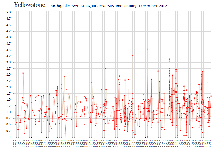
2013 already has the same style
reply to post by muzzy
I can't really find any link. Using Google earth when looking at them, but the coordinates for the last quake is:
49°25'38.94"N - 120°30'40.25"W
Yes, might be quarry but on a straight line?
Ahh.. only link I find is 2.3 magnitude earthquake
Oliver shakes with an earthquake
earthquakescanada
I can't really find any link. Using Google earth when looking at them, but the coordinates for the last quake is:
49°25'38.94"N - 120°30'40.25"W
Yes, might be quarry but on a straight line?
Ahh.. only link I find is 2.3 magnitude earthquake
Oliver shakes with an earthquake
earthquakescanada
edit on 7/7/2013 by Roald
because: Got some links
reply to post by Roald
nightNgale's link to pnsn has details, if you zoom in on the map and click the stars then click the popup for the details
all those events have (Probable explosion) beside the magnitude.
The most southerly event is right beside the "Smelter Lake Tailings Storage Facility"
Huge open cast Copper Mine to the south of that.
Quite likely they are blasting underground shafts to find more copper.
edit:
Those lined up quakes/explosions are to the west of the quake located south of Penticton by about 50km
edit on 7-7-2013 by muzzy because: to
add what I added, doh
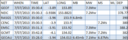
M7.3 - 130km NE of Taron, Papua New Guinea
earthquake.usgs.gov...
deep at 378 km....
Not likely tsunamigenic, except maybe very small local...
That flat out clipped the seismometer at Rabaul
Already dropped to 7.2
earthquake.usgs.gov...
deep at 378 km....
Not likely tsunamigenic, except maybe very small local...
That flat out clipped the seismometer at Rabaul
edit on Sun Jul 7th 2013 by TrueAmerican because: (no reason given)
Already dropped to 7.2
edit on Sun Jul 7th 2013 by TrueAmerican because: (no reason given)
a 7.2 and 6.8, not good. Not good at all. Violates at least one mag separation rule. Seriously, lookout in PNG, big massive one could be coming.
earthquake.usgs.gov...
earthquake.usgs.gov...
edit on Sun Jul 7th 2013 by TrueAmerican because: (no reason
given)
Here is a little quake history for Papua!
www.world-earthquakes.com...
But I really really thought there has been more activity there since 04/13/13, when that list stops listing.
I was looking, because I predicted a big one there(Heheheh), sooner then later.
And now......of course, I can not find where I posted it.
Soooo..... I give a hearty Amen! to TA's warning about a possible biggie!
It smelled like a series of foreshocks...and the 5's have been happening quite regularly since the last 7.1 a year or two ago!
PS.....This area is capable of producing 8+.
www.world-earthquakes.com...
But I really really thought there has been more activity there since 04/13/13, when that list stops listing.
I was looking, because I predicted a big one there(Heheheh), sooner then later.
And now......of course, I can not find where I posted it.
Soooo..... I give a hearty Amen! to TA's warning about a possible biggie!
It smelled like a series of foreshocks...and the 5's have been happening quite regularly since the last 7.1 a year or two ago!
edit on
7-7-2013 by radpetey because: (no reason given)
PS.....This area is capable of producing 8+.
edit on 7-7-2013 by radpetey because: (no reason given)
Just took a quick look at the list, but that region seems to do it's own thing!
Granted, it is only a 6.5+ list, but even with the bigger ones,
the 1 mag less aftershocks just aren't there like you would expect!
11/16 &17/2000- 8, 7.8 & 7.6. No higher 6's at all showing! Weird!
WOQ
Granted, it is only a 6.5+ list, but even with the bigger ones,
the 1 mag less aftershocks just aren't there like you would expect!
11/16 &17/2000- 8, 7.8 & 7.6. No higher 6's at all showing! Weird!
WOQ
M5.8 - 46km SSE of Pujiharjo, Indonesia 2013-07-08 02:13:42 UTC
Event Time
2013-07-08 02:13:42 UTC
2013-07-08 10:13:42 UTC+08:00 at epicenter
2013-07-07 21:13:42 UTC-05:00 system time
Location
8.753°S 113.057°E depth=77.3km (48.0mi)
USGS
M5.9 - 15km SSW of El Rosario, El Salvador 2013-07-08 02:52:47 UTC
Event Time
2013-07-08 02:52:47 UTC
2013-07-07 20:52:47 UTC-06:00 at epicenter
2013-07-07 21:52:47 UTC-05:00 system time
Location
13.362°N 89.079°W depth=96.6km (60.0mi)
Nearby Cities
15km (9mi) SSW of El Rosario, El Salvador
27km (17mi) SW of Zacatecoluca, El Salvador
29km (18mi) ESE of La Libertad, El Salvador
31km (19mi) S of Santo Tomas, El Salvador
38km (24mi) SSE of San Salvador, El Salvador
USGS
Originally posted by TrueAmerican
a 7.2 and 6.8, not good. Not good at all. Violates at least one mag separation rule. Seriously, lookout in PNG, big massive one could be coming.
earthquake.usgs.gov...
Are you refering to The Båth’s Law? which states that the difference in magnitude between a main shock and its largest aftershock is approximately constant, independent of the main shock magnitude, typically 1.1–1.2 magnitude smaller.?
Does not apply here, as the distance between
the New Ireland Region quake
and the New Britain Region quake
is such (519.6 km) that they cannot be considered main and aftershock, but they are separate earthquakes.
This is the problem of Useless using direct location addresses both saying PNG, which although true politically is not as clear as using the F_E Region system where the names are based on seismicity and make it obvious they are separate events.
Besides the MT's are different too.
goo.gl...
edit on 8-7-2013 by muzzy because: (no reason given)
reply to post by muzzy
One agrees with the prognosis.
By the way we so often look at an earthquake, or I do anyway, and only consider the technical aspects. The (relatively) small Mag 6 in Indonesia (Banda Aceh) on the 6th killed 35 people and destroyed 4,300 buildings displacing 6,500 people.
Edit to add:
Except that as I showed last year this rule does not apply to Great Earthquakes (Mag 8+), or at least does not apply to Mag 9 quakes.
One agrees with the prognosis.
By the way we so often look at an earthquake, or I do anyway, and only consider the technical aspects. The (relatively) small Mag 6 in Indonesia (Banda Aceh) on the 6th killed 35 people and destroyed 4,300 buildings displacing 6,500 people.
Edit to add:
independent of the main shock magnitude, typically 1.1–1.2 magnitude smaller.?
Except that as I showed last year this rule does not apply to Great Earthquakes (Mag 8+), or at least does not apply to Mag 9 quakes.
edit on 8/7/2013 by PuterMan because: (no reason given)
Was a 5.1 to start with. Friend up that way said today it was a goodjolt.
i see GFZ have it listed too, wasn't there this morning!
geofon.gfz-potsdam.de...
Public ID 2013p507880
Universal Time July 7 2013 at 21:58:46
NZ Standard Time Monday, July 8 2013 at 9:58:46 am
Latitude, Longitude -39.85, 176.73
Intensity ? moderate
Focal Depth 31 km
Magnitude 4.9
Location 25 km north-east of Waipukurau
Status ? reviewed
www.geonet.org.nz...
i see GFZ have it listed too, wasn't there this morning!
geofon.gfz-potsdam.de...
edit on 9-7-2013 by muzzy because: (no reason given)
finally some after shocks after that 6.0 on 7/6 in the Sumatra
Region
also
USGS
5.1
173km SW of Sungaipenuh, Indonesia
2013-07-09 12:14:20 UTC-05:00 12.5 km
5.6
169km SW of Sungaipenuh, Indonesia
2013-07-09 12:04:14 UTC-05:00 10.3 km
also
5.0
101km ENE of Amahai, Indonesia
2013-07-09 11:15:39 UTC-05:00 20.0 km
5.1
112km ENE of Kyelang, India
2013-07-09 08:49:14 UTC-05:00 17.6 km
USGS
edit on 9-7-2013 by lurksoften because: (no reason given)
reply to post by lurksoften
those locations have no meaning to the average reader, or me.
please provide the F_E region name
those locations have no meaning to the average reader, or me.
please provide the F_E region name
edit on 9-7-2013 by muzzy because: I refuse to open Useless anymore, its such a PITA
I don't see this earthquake listed on any other site, it is so hard to see all earthquakes these days, not sure but I think this is pretty unusual for
this area?
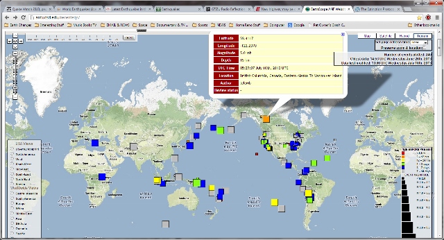
EarthScope
Not sure if you can see the EQ detail
Latitude 59.4117
Longitude -122.2370
Magnitude 5.0 mb
Depth 15 km
UTC Time 05:29:07 July 10th, 2013 UTC
Location British Columbia, Canada, Eastern Alaska To Vancouver Island
Author teleMb
Review status -
EarthScope
Not sure if you can see the EQ detail
Latitude 59.4117
Longitude -122.2370
Magnitude 5.0 mb
Depth 15 km
UTC Time 05:29:07 July 10th, 2013 UTC
Location British Columbia, Canada, Eastern Alaska To Vancouver Island
Author teleMb
Review status -
edit on 7/10/2013 by whatnext21 because: additional info
Originally posted by lurksoften
finally some after shocks after that 6.0 on 7/6 in the Sumatra Region
5.1
173km SW of Sungaipenuh, Indonesia
2013-07-09 12:14:20 UTC-05:00 12.5 km
5.6
169km SW of Sungaipenuh, Indonesia
2013-07-09 12:04:14 UTC-05:00 10.3 km
also
5.0
101km ENE of Amahai, Indonesia
2013-07-09 11:15:39 UTC-05:00 20.0 km
5.1
112km ENE of Kyelang, India
2013-07-09 08:49:14 UTC-05:00 17.6 km
USGSedit on 9-7-2013 by lurksoften because: (no reason given)
Wow, that was confusing! I saw the times and the UTC and did not read the - 5. Is that format another Useless feature?
Curious. You included a quake in India in that lot. Was that just slip of the keyboard or is there some connection to India from Indonesia that we need to know about. (Probably just saw Ind.... and thought Indonesia as we don't see India too often?)
Never mind crochety auld Kiwis - he is having a go at Useless not you.
reply to post by PuterMan
Sorry i will try to be more specific with my posts here. As the last two quakes posted were just eq that had happened at the time of me posting about those aftershocker. They had nothing to do with the first two i posted about.
Sorry i will try to be more specific with my posts here. As the last two quakes posted were just eq that had happened at the time of me posting about those aftershocker. They had nothing to do with the first two i posted about.
edit on 10-7-2013 by lurksoften because: (no reason
given)
Why I went with Geofon for my Moment Tensors page
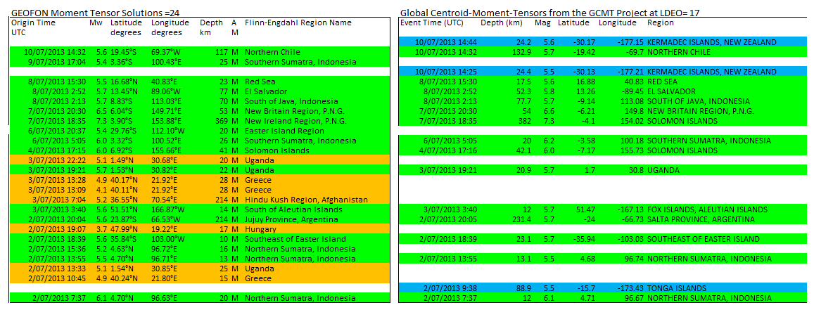
Its a no-brainer really, 24 versus 17
look at all those blank spaces on the right (GCMT/LDEO)
3 on the left (GFZ)
I'll still use LDEO for other maps though, better for locating the South Pacific and Southern Ocean quakes
Its a no-brainer really, 24 versus 17
look at all those blank spaces on the right (GCMT/LDEO)
3 on the left (GFZ)
I'll still use LDEO for other maps though, better for locating the South Pacific and Southern Ocean quakes
edit on 11-7-2013 by muzzy
because: (no reason given)
further to post by muzzy
Damn, theres a problem
I forgot Google Maps interactive i-frames restrict the number of individual icons to 30.
Just uploaded June 2013 and noticed one at Vanuatu was missing, then checked for some others and they weren't showing either.
There were 62 events with MT's in June but only 30 show.
Will have to rethink this one.
They do show on Google Earth and GPS Visualiser though.
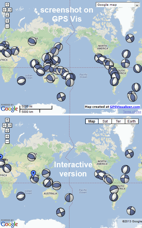
if I restrict the magnitudes to 5.4+ that gives 29 icons
will have a look at a few other months and see if that fits
na thats not going to work either, May has 70 events listed, and would have to be 5.7+ to fit the
Damn, theres a problem
I forgot Google Maps interactive i-frames restrict the number of individual icons to 30.
Just uploaded June 2013 and noticed one at Vanuatu was missing, then checked for some others and they weren't showing either.
There were 62 events with MT's in June but only 30 show.
Will have to rethink this one.
They do show on Google Earth and GPS Visualiser though.
edit on 11-7-2013 by muzzy because: (no reason given)
if I restrict the magnitudes to 5.4+ that gives 29 icons
will have a look at a few other months and see if that fits
edit on 11-7-2013 by muzzy because: (no reason given)
na thats not going to work either, May has 70 events listed, and would have to be 5.7+ to fit the
new topics
-
President BIDEN's FBI Raided Donald Trump's Florida Home for OBAMA-NORTH KOREA Documents.
Political Conspiracies: 4 hours ago -
Maestro Benedetto
Literature: 6 hours ago -
Is AI Better Than the Hollywood Elite?
Movies: 6 hours ago -
Las Vegas UFO Spotting Teen Traumatized by Demon Creature in Backyard
Aliens and UFOs: 9 hours ago -
2024 Pigeon Forge Rod Run - On the Strip (Video made for you)
Automotive Discussion: 10 hours ago -
Gaza Terrorists Attack US Humanitarian Pier During Construction
Middle East Issues: 10 hours ago
top topics
-
President BIDEN's FBI Raided Donald Trump's Florida Home for OBAMA-NORTH KOREA Documents.
Political Conspiracies: 4 hours ago, 26 flags -
Krystalnacht on today's most elite Universities?
Social Issues and Civil Unrest: 15 hours ago, 9 flags -
Supreme Court Oral Arguments 4.25.2024 - Are PRESIDENTS IMMUNE From Later Being Prosecuted.
Above Politics: 15 hours ago, 8 flags -
Weinstein's conviction overturned
Mainstream News: 14 hours ago, 8 flags -
Gaza Terrorists Attack US Humanitarian Pier During Construction
Middle East Issues: 10 hours ago, 8 flags -
Massachusetts Drag Queen Leads Young Kids in Free Palestine Chant
Social Issues and Civil Unrest: 12 hours ago, 7 flags -
Las Vegas UFO Spotting Teen Traumatized by Demon Creature in Backyard
Aliens and UFOs: 9 hours ago, 6 flags -
Meadows, Giuliani Among 11 Indicted in Arizona in Latest 2020 Election Subversion Case
Mainstream News: 12 hours ago, 5 flags -
2024 Pigeon Forge Rod Run - On the Strip (Video made for you)
Automotive Discussion: 10 hours ago, 4 flags -
Is AI Better Than the Hollywood Elite?
Movies: 6 hours ago, 3 flags
active topics
-
Supreme Court Oral Arguments 4.25.2024 - Are PRESIDENTS IMMUNE From Later Being Prosecuted.
Above Politics • 90 • : Lumenari -
Las Vegas UFO Spotting Teen Traumatized by Demon Creature in Backyard
Aliens and UFOs • 12 • : KrustyKrab -
Gaza Terrorists Attack US Humanitarian Pier During Construction
Middle East Issues • 28 • : firerescue -
SHORT STORY WRITERS CONTEST -- April 2024 -- TIME -- TIME2024
Short Stories • 23 • : DontTreadOnMe -
President BIDEN's FBI Raided Donald Trump's Florida Home for OBAMA-NORTH KOREA Documents.
Political Conspiracies • 16 • : Astyanax -
Truth Social goes public, be careful not to lose your money
Mainstream News • 130 • : Astyanax -
Is AI Better Than the Hollywood Elite?
Movies • 13 • : Justoneman -
Hate makes for strange bedfellows
US Political Madness • 47 • : 19Bones79 -
-@TH3WH17ERABB17- -Q- ---TIME TO SHOW THE WORLD--- -Part- --44--
Dissecting Disinformation • 689 • : daskakik -
University of Texas Instantly Shuts Down Anti Israel Protests
Education and Media • 265 • : Astrocometus