It looks like you're using an Ad Blocker.
Please white-list or disable AboveTopSecret.com in your ad-blocking tool.
Thank you.
Some features of ATS will be disabled while you continue to use an ad-blocker.

Quake Watch 2013
page: 109share:
active today in NZ
last one was near me, was probably on the road by then, can't recall what time I left this morning it was a blur
Public Id: 2013p496811
Magnitude: 5.3
Depth: 5 km
Universal Time: 2013-07-03 19:41:06 (GMT)
NZ Time: 2013-07-04 07:41:06 (NZST)
Latitude, Longitude -44.47, 167.84
Intensity ? severe
25 km north-west of Milford Sound
www.geonet.org.nz...
Public Id: 2013p496874
Magnitude: 5.2
Depth: 152 km
Universal Time: 2013-07-03 20:14:37 (GMT)
NZ Time: 2013-07-04 08:14:37 (NZST)
Latitude, Longitude -37.40, 178.64
Intensity ? light
35 km north-east of Te Araroa
www.geonet.org.nz...
Public ID 2013p496876
Universal Time July 3 2013 at 20:15:36
NZ Standard Time Thursday, July 4 2013 at 8:15:36 am
Latitude, Longitude -40.64, 174.18
Intensity ? weak
Focal Depth 86 km
Magnitude[color=9E7BFF] 4.4
Location 45 km north-east of French Pass
www.geonet.org.nz...
last one was near me, was probably on the road by then, can't recall what time I left this morning it was a blur
edit on 4-7-2013 by muzzy
because: (no reason given)
another one, "heard" and "seen" this one ("heard" as in the house creaked but its not windy and too early for a frost,"seen" as in my broken table
lamp with the lens hanging by a wire was twitching for a few seconds, my seismograph if I'm at the desk , and the Internet went off too.
Felt;
Location: Raumati Beach
Intensity: weak to light
Reports: 2
4:07:02 am iiiieeeee! this is going to be a loooooooooong day
Public ID 2013p499112
Universal Time July 4 2013 at 16:07:02
NZ Standard Time Friday, July 5 2013 at 4:07:02 am
Latitude, Longitude -39.67, 174.42
Intensity ? light
Focal Depth 146 km
Magnitude [color=9E7BFF] 4.0
Location 15 km south-east of Hawera
geonet.org.nz...
Felt;
Location: Raumati Beach
Intensity: weak to light
Reports: 2
4:07:02 am iiiieeeee! this is going to be a loooooooooong day
edit on 4-7-2013 by muzzy because: (no reason given)
Originally posted by muzzy
another one, "heard" and "seen" this one ("heard" as in the house creaked but its not windy and too early for a frost,"seen" as in my broken table lamp with the lens hanging by a wire was twitching for a few seconds, my seismograph if I'm at the desk , and the Internet went off too.
Public ID 2013p499112
Universal Time July 4 2013 at 16:07:02
NZ Standard Time Friday, July 5 2013 at 4:07:02 am
Latitude, Longitude -39.67, 174.42
Intensity ? light
Focal Depth 146 km
Magnitude [color=9E7BFF] 4.0
Location 15 km south-east of Hawera
geonet.org.nz...
Felt;
Location: Raumati Beach
Intensity: weak to light
Reports: 2
4:07:02 am iiiieeeee! this is going to be a loooooooooong day
edit on 4-7-2013 by muzzy because: (no reason given)
A potentially sketchy situation, when NZ starts spitting out 5's so close together!!
Hang in there........maybe literally
M6.1 - 81km SSE of Panguna, Papua New Guinea 2013-07-04 17:16:00 UTC
Event Time
2013-07-04 17:16:00 UTC
2013-07-05 04:16:00 UTC+11:00 at epicenter
2013-07-04 12:16:00 UTC-05:00 system time
Location
7.039°S 155.644°E depth=72.0km (44.7mi)
Nearby Cities
81km (50mi) SSE of Panguna, Papua New Guinea
92km (57mi) S of Arawa, Papua New Guinea
478km (297mi) SE of Kokopo, Papua New Guinea
543km (337mi) WNW of Honiara, Solomon Islands
630km (391mi) ESE of Kimbe, Papua New Guinea
USGS
There was a 5.4 Uganda on USGS, just in the last 5 minutes but then it was poof... gone.
just making a note
just making a note
I wonder if this is gonna be another, Here we go again in this area?
reply to post by muzzy
You just had to post those 5's hours after I booked my tickets to over your way! I hope to feel one - (obviously not a big one though )
You just had to post those 5's hours after I booked my tickets to over your way! I hope to feel one - (obviously not a big one though )
Magnitude mb 4.9
Region ANTOFAGASTA, CHILE
Date time 2013-07-05 00:41:28.0 UTC
Location 22.58 S ; 68.53 W
Depth 118 km
Distances 519 km SW of Sucre, Bolivia / pop: 224,838 / local time: 20:41:28.0 2013-07-04
225 km NE of Antofagasta, Chile / pop: 309,832 / local time: 20:41:28.0 2013-07-04
43 km E of Calama, Chile / pop: 143,084 / local time: 20:41:28.0 2013-07-04
www.emsc-csem.org...
hmm....
www.emsc-csem.org...
Magnitude ML 3.7
Region OFFSHORE COQUIMBO, CHILE
Date time 2013-07-04 23:20:44.0 UTC
Location 29.77 S ; 71.61 W
Depth 40 km
Distances 418 km N of Santiago, Chile / pop: 4,837,295 / local time: 19:20:44.0 2013-07-04
37 km NW of La Serena, Chile / pop: 154,521 / local time: 19:20:44.0 2013-07-04
hmm,hmm?
reply to post by piequal3because14
Haven't seen your name before, so if you are new welcome to QW 2013.
I see your in your profile is "Location: Paradise", so what part of New Zealand are you in?
If Chile is your interest, you may find this worth a look
Chile eqarchives
2012 is available as well from the 2012 dropdown tab off the main Chile tab at the top.
The data the maps are based on is from Servicio Sismológico de la Universidad de Chile, Santiago Chile. (SSUCH), the EMSC coverage of Chile is just a recent addition to their system and not all quakes are reported.
I find it surprising how few quakes Chile gets per month, when you consider how many biguns it gets historically, seems to be a shortage of mag 1's, could be the type of seismo's they use.
edit on 5-7-2013 by muzzy because: (no reason given)
reply to post by muzzy
And thank you for the links,indeed Chile is situated on the South American continent and it has as neighbours Peru, Bolivia and Argentina.
Thank you for the warm wellcoming in your thread Mr Muzzy,the Borg should be here any minute....
Haven't seen your name before, so if you are new welcome to QW 2013.
I see your in your profile is "Location: Paradise", so what part of New Zealand are you in?
And thank you for the links,indeed Chile is situated on the South American continent and it has as neighbours Peru, Bolivia and Argentina.
if this format is available elsewhere on the Internet, pleeeeaaase someone let me know before I go too far with it
maps (monthly) of Geofon (GFZ) Moment Tensor Solutions.
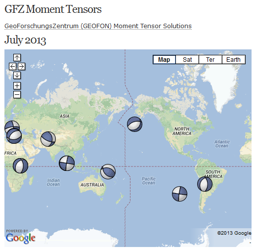 [color=8BB381](click image for page, opens in new
tab/window)
[color=8BB381](click image for page, opens in new
tab/window)
One day I'll figure out how to determine the type of earthquake each one is by the beachballs, at this stage its a mystery as there are only 5 main types, but in reality GFZ (and IRIS, Useless and EMSC el al) put out hundreds of variations)
all-geo.org...
ETA:
maybe anyone in the know can clarify if I am wrong
from that July map
Sumatra, Easter Island and Hungary are clearly "strike/slip shear"
Uganda, Jujuy and Aluetians could be "normal/extension" but the angle of the beachball is to the right rather than the left as shown in all-geo.org...'s images
Hindu Kush is "transtension" (extension+shear)
Solomon Is is "transpression" (compression +shear) or it could be "reverse/thrust/compression"
Greece could be "normal/extension" or "transtension"
pretty confusing, the angle of the dark or light sections varies
I would have expected Aluetians, Jujuy, Solomons and Indonesia to all be "reverse/thrust/compression" because they are on subduction plate interfaces, and Uganda to be "strike/slip shear" or "transtension" (extension+shear) because its on the Rift Valley.
maps (monthly) of Geofon (GFZ) Moment Tensor Solutions.
One day I'll figure out how to determine the type of earthquake each one is by the beachballs, at this stage its a mystery as there are only 5 main types, but in reality GFZ (and IRIS, Useless and EMSC el al) put out hundreds of variations)
all-geo.org...
ETA:
maybe anyone in the know can clarify if I am wrong
from that July map
Sumatra, Easter Island and Hungary are clearly "strike/slip shear"
Uganda, Jujuy and Aluetians could be "normal/extension" but the angle of the beachball is to the right rather than the left as shown in all-geo.org...'s images
Hindu Kush is "transtension" (extension+shear)
Solomon Is is "transpression" (compression +shear) or it could be "reverse/thrust/compression"
Greece could be "normal/extension" or "transtension"
pretty confusing, the angle of the dark or light sections varies
I would have expected Aluetians, Jujuy, Solomons and Indonesia to all be "reverse/thrust/compression" because they are on subduction plate interfaces, and Uganda to be "strike/slip shear" or "transtension" (extension+shear) because its on the Rift Valley.
edit on 5-7-2013 by muzzy because: (no reason given)
reply to post by piequal3because14
www.emsc-csem.org...
Like here,
And thank you for the links,indeed Chile is situated on the South American continent and it has as neighbours Peru, Bolivia and Argentina.
Magnitude ML 4.1
Region POTOSI, BOLIVIA
Date time 2013-07-05 19:22:29.0 UTC
Location 21.31 S ; 67.91 W
Depth 222 km
Distances 374 km SW of Sucre, Bolivia / pop: 224,838 / local time: 15:22:29.0 2013-07-05
261 km SE of Iquique, Chile / pop: 227,499 / local time: 15:22:29.0 2013-07-05
146 km SW of Uyuni, Bolivia / pop: 10,293 / local time: 15:22:29.0 2013-07-05
www.emsc-csem.org...
Also this is a very interesting sequence,
www.emsc-csem.org...
2013-07-05 14:25:26.06hr 26min ago 14.74 N 52.41 E 33 4.6 GULF OF ADEN
2013-07-05 13:52:17.07hr 00min ago 14.76 N 52.34 E 200 4.5 GULF OF ADEN
2013-07-05 13:20:27.07hr 31min ago 14.78 N 52.34 E 10 4.7 GULF OF ADEN
www.emsc-csem.org...
edit on 5-7-2013 by piequal3because14 because: a
Originally posted by muzzy
maybe anyone in the know can clarify if I am wrong
from that July map
Sumatra, Easter Island and Hungary are clearly "strike/slip shear"
Uganda, Jujuy and Aluetians could be "normal/extension" but the angle of the beachball is to the right rather than the left as shown in all-geo.org...'s images
Hindu Kush is "transtension" (extension+shear)
Solomon Is is "transpression" (compression +shear) or it could be "reverse/thrust/compression"
Greece could be "normal/extension" or "transtension"
pretty confusing, the angle of the dark or light sections varies
I would have expected Aluetians, Jujuy, Solomons and Indonesia to all be "reverse/thrust/compression" because they are on subduction plate interfaces, and Uganda to be "strike/slip shear" or "transtension" (extension+shear) because its on the Rift Valley.
edit on 5-7-2013 by muzzy because: (no reason given)
I agree with all of your interpretations of the beachballs, but since I am a USGS cottled 'Murican, I would say the transpression=oblique reverse, and transtension=normal faulting with a strike-slip component.
Agreed, that because of their subduction locations, you would think all 4 would be thrust mechanisms, but when I looked at the depths, it makes sense.
1. Aluetians at only 5km depth, is probably due to the Pacific plate beginning it's bend down toward the subduction zone.
2. Jujay at 190km+ depth is probably due to internal deformation of the subducting Nazca plate.
3. Solomons looks like reverse faulting.
4. Indonesia is an upper plate event of which your pals at USGS say (6) Mag 6+ have occurred within 250km in the past 40 years & that they are particularly dangerous.
Nice find of the monthly maps, btw.
reply to post by Olivine
thanks for the conformation, but don't confuse me with "oblique" though, thats not mentioned in the blog writing/images.
There is obviously more to these balls than what I was hoping, I had a look at this once before and gave up.
So yes you need the depth to know for sure, which is why the details are in the popup tags.
"Find" ? I didn't find the maps I created them from scratch, based on the GFZ list, which is linked at the top of the page
As it turned out the little beachball icons there on the list are the same size as what I use on all my other maps 32x32 which is the default size for Google Maps without distortion.
I chose GFZ over IRIS, Useless and EMSC becasue their beachballs are consistant in size and definition.
What lead me to do this was I was getting sick of having to click on each item/line in the GFZ list to see the details, now they are all on one map (per month). Of course even that is self defeating now as I have to click on them anyway to get the details to enter into the html for the popup tags
I'll keep at it as long as someone looks at the page.
edit on 5-7-2013 by muzzy because: (no reason given)
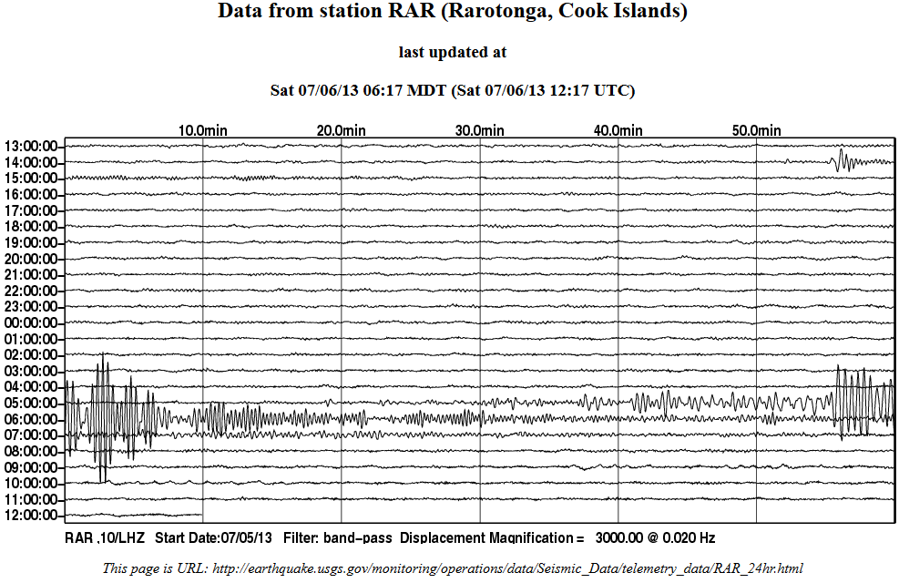
M6.0 - 157km SW of Sungaipenuh, Indonesia 2013-07-06 05:05:06 UTC
Event Time
2013-07-06 05:05:06 UTC
2013-07-06 12:05:06 UTC+07:00 at epicenter
2013-07-06 00:05:06 UTC-05:00 system time
Location
3.249°S 100.567°E depth=19.7km (12.2mi)
Nearby Cities
157km (98mi) SW of Sungaipenuh, Indonesia
198km (123mi) WNW of Bengkulu, Indonesia
219km (136mi) W of Curup, Indonesia
255km (158mi) S of Padang, Indonesia
620km (385mi) SW of Singapore, Singapore
USGSedit on 6-7-2013 by lurksoften because: (no reason given)
www.ldeo.columbia.edu/~ekstrom/Research/SWD/current/RADB_SWD_grd.html
2013 7 5 14 48 8.0 -27.75 -176.25 33.0 5.1 KERMADEC ISLANDS REGION


As I normally do the first weekend after the end of the month, update the various countries earthquakes for the past month.
Having trouble with Turkey, DDA cataloug won't give me the entire month, the search results keeps reverting to last 30 days like the Kandilli Observatory does. So I'm missing the first 6 days of June.
All the others have been updated, except Colombia.
eqarchives.wordpress.com...
Pretty quiet month globally except for Italy, double the numbers ( 2092 above mag 1), because of the Forzone – Minucciano , Massa/Lucca/Carrara, Italy 21/06/2013, 5.2ML and aftershocks.
Will leave June 2013 behind with the interactive map of the month, June Italy, focused on Forzone – Minucciano
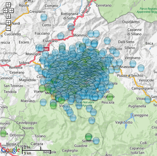 [color=8BB381](click image for interactive map, opens in new tab/window)
I've given up on using Useless's (USGS) web pages all together , only use ANSS now, and only for Yellowstone data.
Having trouble with Turkey, DDA cataloug won't give me the entire month, the search results keeps reverting to last 30 days like the Kandilli Observatory does. So I'm missing the first 6 days of June.
All the others have been updated, except Colombia.
eqarchives.wordpress.com...
Pretty quiet month globally except for Italy, double the numbers ( 2092 above mag 1), because of the Forzone – Minucciano , Massa/Lucca/Carrara, Italy 21/06/2013, 5.2ML and aftershocks.
Will leave June 2013 behind with the interactive map of the month, June Italy, focused on Forzone – Minucciano
I've given up on using Useless's (USGS) web pages all together , only use ANSS now, and only for Yellowstone data.
edit on 6-7-2013 by muzzy because: ATS loading images slow today!
Can someone satisfy my curiosity regarding some quakes in Canada?
I am referring to four -4- small quakes at Allenby, just south of Princeton, British Columbia.
The first was a M 2.4, on Sunday, June 30, 2013 21:10:20 UTC with a depth of 0.00 km (0.00 mi)
The next was a M 2.3, on Wednesday, July 3, 2013 21:20:25 UTC with a depth of 0.00 km (0.00 mi)
Followed by a M 2.3, on Thursday, July 4, 2013 21:19:15 UTC with a depth of 0.00 km (0.00 mi)
Ending with a M 2.3, on Saturday, July 6, 2013 17:10:15 UTC with a depth of 0.00 km (0.00 mi)
All 4 quakes lay in a straight line from South to North and with a total distance of 5,28 km (3,28 mi) from the first to the last.
How come a straight line and 0 depth?
new topics
-
Pentagon acknowledges secret UFO project, the Kona Blue program | Vargas Reports
Aliens and UFOs: 36 minutes ago -
Boston Dynamics say Farewell to Atlas
Science & Technology: 44 minutes ago -
I hate dreaming
Rant: 1 hours ago -
Is the origin for the Eye of Horus the pineal gland?
Philosophy and Metaphysics: 3 hours ago -
Man sets himself on fire outside Donald Trump trial
Mainstream News: 3 hours ago -
Biden says little kids flip him the bird all the time.
2024 Elections: 3 hours ago -
The Democrats Take Control the House - Look what happened while you were sleeping
US Political Madness: 4 hours ago -
Sheetz facing racial discrimination lawsuit for considering criminal history in hiring
Social Issues and Civil Unrest: 4 hours ago -
In an Historic First, In N Out Burger Permanently Closes a Location
Mainstream News: 6 hours ago -
MH370 Again....
Disaster Conspiracies: 6 hours ago
top topics
-
In an Historic First, In N Out Burger Permanently Closes a Location
Mainstream News: 6 hours ago, 14 flags -
The Democrats Take Control the House - Look what happened while you were sleeping
US Political Madness: 4 hours ago, 10 flags -
Thousands Of Young Ukrainian Men Trying To Flee The Country To Avoid Conscription And The War
Other Current Events: 16 hours ago, 8 flags -
A man of the people
Medical Issues & Conspiracies: 11 hours ago, 8 flags -
Man sets himself on fire outside Donald Trump trial
Mainstream News: 3 hours ago, 7 flags -
Biden says little kids flip him the bird all the time.
2024 Elections: 3 hours ago, 6 flags -
4 plans of US elites to defeat Russia
New World Order: 13 hours ago, 4 flags -
Is the origin for the Eye of Horus the pineal gland?
Philosophy and Metaphysics: 3 hours ago, 4 flags -
Sheetz facing racial discrimination lawsuit for considering criminal history in hiring
Social Issues and Civil Unrest: 4 hours ago, 3 flags -
Are you ready for the return of Jesus Christ? Have you been cleansed by His blood?
Religion, Faith, And Theology: 8 hours ago, 3 flags
active topics
-
Elites disapearing
Political Conspiracies • 33 • : 0bserver1 -
Man sets himself on fire outside Donald Trump trial
Mainstream News • 29 • : ByeByeAmericanPie -
Fossils in Greece Suggest Human Ancestors Evolved in Europe, Not Africa
Origins and Creationism • 78 • : strongfp -
Pentagon acknowledges secret UFO project, the Kona Blue program | Vargas Reports
Aliens and UFOs • 2 • : Macenroe1982 -
In an Historic First, In N Out Burger Permanently Closes a Location
Mainstream News • 8 • : KrustyKrab -
12 jurors selected in Trump criminal trial
US Political Madness • 104 • : Annee -
Russian intelligence officer: explosions at defense factories in the USA and Wales may be sabotage
Weaponry • 175 • : Freeborn -
Thousands Of Young Ukrainian Men Trying To Flee The Country To Avoid Conscription And The War
Other Current Events • 36 • : Xtrozero -
Are you ready for the return of Jesus Christ? Have you been cleansed by His blood?
Religion, Faith, And Theology • 19 • : glend -
I hate dreaming
Rant • 4 • : Macenroe1982