It looks like you're using an Ad Blocker.
Please white-list or disable AboveTopSecret.com in your ad-blocking tool.
Thank you.
Some features of ATS will be disabled while you continue to use an ad-blocker.

The Perfect Storm
page: 13share:
Okay here is the 5:45 ET image. Once again, I include the previous first for comparison. The eye is bigger, but it is elongating and becoming less
defined. Let's hope it got so big it can't maintain itself. That doesn't lessen the pounding, water-wise, the east coast is going to take, but it at
least can make us have hope it won't continue to intensify.
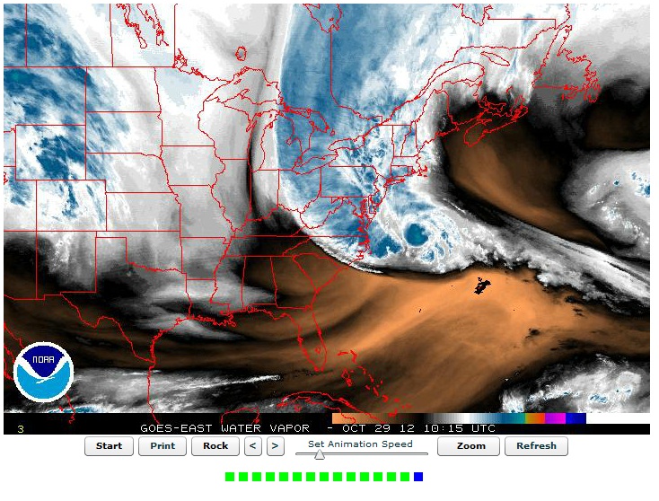
edit on 10-29-2012 by Valhall because: (no reason given)
Link 941mb
I'm hearing pressure is down to 941mb - Isn't that CAT 3 territory?
I'm hearing pressure is down to 941mb - Isn't that CAT 3 territory?
edit on 29-10-2012 by Phoenix because: (no reason
given)
edit on 29-10-2012 by Phoenix because: (no reason given)
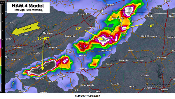
For those in the North Carolina/East Tennessee Mountains.
This has snow in the mountains along the state border at 30-40 inches! I have not seen that prediction. Let's hope it is wrong.
twitter.com
Like I said this is the only place I have seen this, but heads up none the less.
This has snow in the mountains along the state border at 30-40 inches! I have not seen that prediction. Let's hope it is wrong.
@wxbrad
Chief Meteorologist at WCNC-TV NBC Charlotte Major Weather & Tech Geek! I Blog at wxbrad.com #cltwx #ncwx #scwx
twitter.com
Like I said this is the only place I have seen this, but heads up none the less.
reply to post by Phoenix
Its to do with wind speed I thought
library.thinkquest.org...
Its to do with wind speed I thought
library.thinkquest.org...
edit on 29-10-2012 by gps777 because: I thought.
Originally posted by Phoenix
I'm hearing pressure is down to 941mb - Isn't that CAT 3 territory?
I heard them say that on the Weather Channel just about an hour ago. One of the planes that went in recorded 941 for pressure. It's not on their site .. but the weather forecaster said it.
As soon as this thing hits land, it will no longer be a hurricane. They are going to switch over to 'Nor'easter' and drop the 'hurricane' title. That's what they said. That's why there are no hurricane warnings up for Delaware/NewJersey/New York. Around here, everyone is just calling it FRANKENSTORM.
reply to post by gps777
Yes, but she is somewhat correct as well. The wind speeds correlate indirectly with the pressure reading. Lower the pressure, higher the windspeeds.
ww2010.atmos.uiuc.edu...
940 is a really low pressure
Yes, but she is somewhat correct as well. The wind speeds correlate indirectly with the pressure reading. Lower the pressure, higher the windspeeds.
ww2010.atmos.uiuc.edu...
940 is a really low pressure
reply to post by OneisOne
Holy cow! Those mountain passes will be closed for awhile if that is the case. Hope the tourists in Gatlinburg get out of there, or else they will be in for an extended vacation,
Holy cow! Those mountain passes will be closed for awhile if that is the case. Hope the tourists in Gatlinburg get out of there, or else they will be in for an extended vacation,
Lowest pressure recorded in Katrina was 902 and the pressure was 920 when it landed. Just for perspective.
reply to post by OneisOne
I have family in Newland, NC area. They said it started snowing there yesterday. Raysweather.com is a pretty good source of forecasting info and calls for several feet of snow. I lived there for 7 years and think it will be at least 3 feet or better.
I have family in Newland, NC area. They said it started snowing there yesterday. Raysweather.com is a pretty good source of forecasting info and calls for several feet of snow. I lived there for 7 years and think it will be at least 3 feet or better.
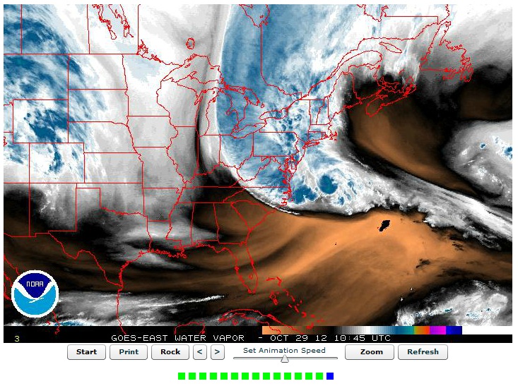
Okay, I'm not going to keep cluttering the thread with the images, but the newest image (6:15 ET) shows the eye collapsing.
www.ssd.noaa.gov...
...which is really really good.
www.ssd.noaa.gov...
...which is really really good.
Hurricane Agnes in 72' only had pressure of 977mb at its lowest reading. Agnes caused over 3 billion in damage. I personally saw much of the damage
along the Sesquahanna river basin myself. I know all eyes are on coastal areas but many inland valleys and river basins will accentuate flood damage
beyond whats normally seen in gulf states.
Agnes
Agnes
edit on 29-10-2012 by Phoenix because: sp
The Bounty crew have abandoned ship. The 17 are now in two lifeboats.
Prayers their way.
www.foxnews.com...
Prayers their way.
www.foxnews.com...
reply to post by Phoenix
Thank you for this reminder. The same thing was true for Katrina. There were many many inland areas that were destroyed from flooding, but the population centers/coastal cities got all the press coverage and people didn't realize how far reaching the devastation really was.
Thank you for this reminder. The same thing was true for Katrina. There were many many inland areas that were destroyed from flooding, but the population centers/coastal cities got all the press coverage and people didn't realize how far reaching the devastation really was.
Latest update:
www.nhc.noaa.gov...
At this time they stated 946 mb. Sustained winds of 85 mph. Tropical storm winds extending 485 miles (that's the radius...not the diameter).
www.nhc.noaa.gov...
At this time they stated 946 mb. Sustained winds of 85 mph. Tropical storm winds extending 485 miles (that's the radius...not the diameter).
reply to post by Valhall
Ok thanks,that link I posted is only showing the pressure in inchs.
Do you know what 940 mb would equate the wind speed to be approximately?
EDIT.. never mind,just saw your post.
When we get cyclones over here (and been through some big ones myself),the worrying time is when they slow down over the ocean,which allows them to build up strength,they`ll cross landfall and start to dissipate while doing their damage.
It seems a whole other ball game over there,with way different weather conditions coming into play.
I don`t believe the media is just hyping this storm up.
Be prepared people,better to be safe than sorry.
edit on 29-10-2012 by gps777 because: Edit
reply to post by gps777
No, the same is true here. The slower they go over warm waters, the more likely they intensive and gain structure.
Right now NOAA is stating 946 mb and 85 mph sustained (with gusts much higher).
No, the same is true here. The slower they go over warm waters, the more likely they intensive and gain structure.
Right now NOAA is stating 946 mb and 85 mph sustained (with gusts much higher).
Originally posted by Valhall
Latest update:
www.nhc.noaa.gov...
At this time they stated 946 mb. Sustained winds of 85 mph. Tropical storm winds extending 485 miles (that's the radius...not the diameter).
Reading that update she's turned bit left as forecast to north-northwest. the earlier update had due north.
Wilmington DE ... okay .... the storm is picking up. We've had a soaking rain for over 12 hours and now the WIND has kicked in. Rain and wind.
Still have 36 hours to go before the EYE passes over. Man ... 'power please stay on ..power please stay on ... ' ....
Originally posted by Valhall
reply to post by gps777
No, the same is true here. The slower they go over warm waters, the more likely they intensive and gain structure.
Right now NOAA is stating 946 mb and 85 mph sustained (with gusts much higher).
Pretty sure the gusts are 80-85 with sustained around 30-40...according to the national weather service. Maybe you read it wrong.
Edit: whoops 35-45 sustained.
edit on 29-10-2012 by Malcher because: (no reason given)
new topics
-
James O’Keefe: I have evidence that exposes the CIA, and it’s on camera.
Whistle Blowers and Leaked Documents: 42 minutes ago -
Australian PM says the quiet part out loud - "free speech is a threat to democratic dicourse"...?!
New World Order: 1 hours ago -
Ireland VS Globalists
Social Issues and Civil Unrest: 1 hours ago -
Biden "Happy To Debate Trump"
Mainstream News: 2 hours ago -
RAAF airbase in Roswell, New Mexico is on fire
Aliens and UFOs: 2 hours ago -
What is the white pill?
Philosophy and Metaphysics: 4 hours ago -
Mike Pinder The Moody Blues R.I.P.
Music: 4 hours ago -
Putin, Russia and the Great Architects of the Universe
ATS Skunk Works: 7 hours ago
top topics
-
A Warning to America: 25 Ways the US is Being Destroyed
New World Order: 12 hours ago, 20 flags -
Mike Pinder The Moody Blues R.I.P.
Music: 4 hours ago, 7 flags -
What is the white pill?
Philosophy and Metaphysics: 4 hours ago, 5 flags -
Biden "Happy To Debate Trump"
Mainstream News: 2 hours ago, 5 flags -
Australian PM says the quiet part out loud - "free speech is a threat to democratic dicourse"...?!
New World Order: 1 hours ago, 5 flags -
RAAF airbase in Roswell, New Mexico is on fire
Aliens and UFOs: 2 hours ago, 4 flags -
Putin, Russia and the Great Architects of the Universe
ATS Skunk Works: 7 hours ago, 3 flags -
Ireland VS Globalists
Social Issues and Civil Unrest: 1 hours ago, 2 flags -
James O’Keefe: I have evidence that exposes the CIA, and it’s on camera.
Whistle Blowers and Leaked Documents: 42 minutes ago, 2 flags
active topics
-
University of Texas Instantly Shuts Down Anti Israel Protests
Education and Media • 294 • : FlyersFan -
Las Vegas UFO Spotting Teen Traumatized by Demon Creature in Backyard
Aliens and UFOs • 17 • : rickymouse -
James O’Keefe: I have evidence that exposes the CIA, and it’s on camera.
Whistle Blowers and Leaked Documents • 7 • : pianopraze -
Krystalnacht on today's most elite Universities?
Social Issues and Civil Unrest • 8 • : FlyersFan -
Gaza Terrorists Attack US Humanitarian Pier During Construction
Middle East Issues • 87 • : YourFaceAgain -
-@TH3WH17ERABB17- -Q- ---TIME TO SHOW THE WORLD--- -Part- --44--
Dissecting Disinformation • 698 • : Thoughtful3 -
Supreme Court Oral Arguments 4.25.2024 - Are PRESIDENTS IMMUNE From Later Being Prosecuted.
Above Politics • 100 • : Vermilion -
Russia Ukraine Update Thread - part 3
World War Three • 5735 • : gortex -
"We're All Hamas" Heard at Columbia University Protests
Social Issues and Civil Unrest • 288 • : FlyersFan -
Biden "Happy To Debate Trump"
Mainstream News • 31 • : theatreboy