It looks like you're using an Ad Blocker.
Please white-list or disable AboveTopSecret.com in your ad-blocking tool.
Thank you.
Some features of ATS will be disabled while you continue to use an ad-blocker.

Warning of More Flooding in England on Friday (6th July)
page: 13
share:
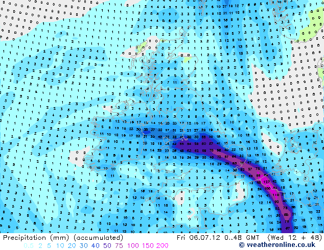
Current model output suggests up to 4 inches of rain could fall over the next couple of days in parts of England and Wales as a front becomes slow
moving on Friday. Flooding looks very likely in place. For example, Leicestershire has had a lot of rain lately, and the ground there is very
saturated, and looks right in the firing line.
Worth keeping an eye on Met Office warnings and if you live in an area prone to flooding, especially in a swath running up from SE England to the north Midlands and across west into Wales, be prepared.
Latest MetO warnings:
www.metoffice.gov.uk...
Heavy thundery showers likely in areas not hit by the more peristent frontal rain.
I'm pleased to see that river levels here are not much above theur normal summer minimum and we should miss the heaviest rain, though upstream from here could be hit badly so some riverside flooding is possible, though in my opinion not beynd normal winter levels at worst.
Please remember that details may well change nearer the time - I'll post updates as I know more.
This summer realy is turning into a repeat of 2007
MetO news release:
www.metoffice.gov.uk...
A low pressure system which has moved in from the west is set to be positioned over or close to the UK until early next week, bringing in a series of rain-bearing weather fronts and generating thundery showers at times.
Martin Young, Chief Forecaster at the Met Office, said: "We are expecting outbreaks of heavy rain across a wide area of the UK, with worst affected spots likely to be in central and northern parts of the country.
"Rainfall totals could be 40-60mm widely across warning areas, but some places could see up to 100mm of rain through Friday and into Saturday. Given the saturated ground from the record rainfall in June, this could cause disruption - including difficult driving conditions and flooding in some areas."
www.metoffice.gov.uk...
Damn! Not good at all.
In Manchester it rained like crazy for about an hour a bit ago. The hardest and longest rain I have ever seen.
In Manchester it rained like crazy for about an hour a bit ago. The hardest and longest rain I have ever seen.
Is this actually news? All we've had in Wales for the last week is rain.
The amount of rain expected Fri (and though into Sat) is itself cause for concern, but falling in areas that already have saturated ground after last
month (a friend in Leics had 379% of normal rain last month - with over 56mm - a month's worth itself - falling last Turs alone) the likelihood of
more widespread flooding as we saw in 2007 is a possibility. Hopefully it won't be as bad but I fear some folk are in for a bad time.
Travel disruption also likely on Fri and through the weekend - so anyone travelling, especially across the N Midlands - should be aware of that too.
Travel disruption also likely on Fri and through the weekend - so anyone travelling, especially across the N Midlands - should be aware of that too.
just had an incredibly heavy rainstorm here (manchester). the sky is dark and promises more of the same. this is, even by uk standards, one great
big washout of a summer.
Originally posted by XeroOne
Is this actually news? All we've had in Wales for the last week is rain.
Aye, I guess the fact it's going to rain is hardly news - as I've said elsewhere this week, at least the current synoptics makes forecasting easy: it'll rain, every day for the next 2 weeks at least! But as mentioned, the amount falling the end of this week could give rise to very serious flooding and folk need to be prepared.
Actually not much change, with the Midlands north and east of Birmingham - including Leics where friends report the ground is already waterlogged -
being worst hit tomorrow. Parts of northern England then seeing heavy rain tomorrow night and Saturday with this also pushing in to southern
Scotland.
Fairly widepread travel disruption (roads and trains) looks likely.
Also worth noting that yesterday flash floods brought chaos to evening rush hour traffic in the Central Belt of Scotland, with more floods hitting N Ireland today. But I expect tomorrow and Saturday's rain will be the big news story.
It's a not dissimilar looking event to the record rain and floods that occurred on the 20th July 2007 in the south Midlands
The rain we had on Wed. evening (Glasgow) from around 4.30pm to 7.30pm was unbelievable. I honestly cannot say the last time we had rain as heavy.
We were trying to get out to my partners father who stays in suburban Glasgow and we had to turn back as all entrances to the roads leading out of town were flooded in someway, nearly a foot deep in places. We ended up on a grass verge to get onto the M8 as we had to turn back and it was pretty scary in a couple of places with the amount of water on the road. At my partners cousins house, there was a family taking turns in a canoe, going up and down the flooded road, just paddling away ... at least some folk got some fun out of it.
Today there was still a few roads left with flood water, but it was the usual places where water accumulates no matter how heavy the rain. Thankfully though today was much better with no rain in the city centre at least.
Vitamin D, with this damned weather I think we all need it.
Stay safe everyone if your area is under a flood warning.
Just a quick update to say it currently looks like the worst of the rain - and consequential flooding - may be over the south Pennines (including
Manchester, Sheffield & Leeds areas).
Latest Env Agency Flood Alerts:
www.environment-agency.gov.uk...
Latest Env Agency Flood Alerts:
www.environment-agency.gov.uk...
last night we had a crazy lghtning and thunderstorm with immense rain!
it was quality to watch
im just north of Preston UK
today it is just relentless heavy rain from around 8ish this morning
it was quality to watch
im just north of Preston UK
today it is just relentless heavy rain from around 8ish this morning
Awesome another weather thread!
I have to say the rain about 11.30pm last night was epic. Didn't last long though, it's only the normal mild pishy stuff now. My back garden is waterlogged in places mind.
I have to say the rain about 11.30pm last night was epic. Didn't last long though, it's only the normal mild pishy stuff now. My back garden is waterlogged in places mind.
As predicted, widespread flooding and travel disruption ie:
www.telegraph.co.uk...
www.bbc.co.uk...
www.bbc.co.uk...
18.6mm here (rain has stopped in last half hour) - makes it my wettest day of the year and since August 26th 2011
SW looks like getting hit tomorrow, with some heavy showers elsewhere that may lead to more flash flooding due to already saturated ground.
Fortunately, it looks like drying out a bit in most parts next week, at least for a few days.
The MetO now has a rare Red Warning for south Devon, including Dartmoor, for tomorrow
www.metoffice.gov.uk...
www.metoffice.gov.uk...
Yup and working on the Ambulances we may have a busy weekend. Red alert at my location too.
new topics
-
A Warning to America: 25 Ways the US is Being Destroyed
New World Order: 31 minutes ago -
America's Greatest Ally
General Chit Chat: 1 hours ago -
President BIDEN's FBI Raided Donald Trump's Florida Home for OBAMA-NORTH KOREA Documents.
Political Conspiracies: 6 hours ago -
Maestro Benedetto
Literature: 7 hours ago -
Is AI Better Than the Hollywood Elite?
Movies: 7 hours ago -
Las Vegas UFO Spotting Teen Traumatized by Demon Creature in Backyard
Aliens and UFOs: 11 hours ago
top topics
-
President BIDEN's FBI Raided Donald Trump's Florida Home for OBAMA-NORTH KOREA Documents.
Political Conspiracies: 6 hours ago, 27 flags -
Krystalnacht on today's most elite Universities?
Social Issues and Civil Unrest: 17 hours ago, 9 flags -
Supreme Court Oral Arguments 4.25.2024 - Are PRESIDENTS IMMUNE From Later Being Prosecuted.
Above Politics: 17 hours ago, 8 flags -
Weinstein's conviction overturned
Mainstream News: 15 hours ago, 8 flags -
Gaza Terrorists Attack US Humanitarian Pier During Construction
Middle East Issues: 12 hours ago, 8 flags -
Massachusetts Drag Queen Leads Young Kids in Free Palestine Chant
Social Issues and Civil Unrest: 14 hours ago, 7 flags -
Las Vegas UFO Spotting Teen Traumatized by Demon Creature in Backyard
Aliens and UFOs: 11 hours ago, 6 flags -
Meadows, Giuliani Among 11 Indicted in Arizona in Latest 2020 Election Subversion Case
Mainstream News: 14 hours ago, 5 flags -
2024 Pigeon Forge Rod Run - On the Strip (Video made for you)
Automotive Discussion: 12 hours ago, 4 flags -
Is AI Better Than the Hollywood Elite?
Movies: 7 hours ago, 3 flags
active topics
-
Is AI Better Than the Hollywood Elite?
Movies • 17 • : ThePsycheaux -
The best Rice dish i've ever tasted... Kimchi Rice
Food and Cooking • 26 • : lamhaocc -
A Warning to America: 25 Ways the US is Being Destroyed
New World Order • 1 • : 727Sky -
Massachusetts Drag Queen Leads Young Kids in Free Palestine Chant
Social Issues and Civil Unrest • 15 • : tarantulabite1 -
America's Greatest Ally
General Chit Chat • 1 • : BingoMcGoof -
How ageing is" immune deficiency"
Medical Issues & Conspiracies • 35 • : annonentity -
HORRIBLE !! Russian Soldier Drinking Own Urine To Survive In Battle
World War Three • 49 • : Freeborn -
Gaza Terrorists Attack US Humanitarian Pier During Construction
Middle East Issues • 30 • : Asher47 -
Electrical tricks for saving money
Education and Media • 8 • : anned1 -
Hate makes for strange bedfellows
US Political Madness • 48 • : Terpene
3