It looks like you're using an Ad Blocker.
Please white-list or disable AboveTopSecret.com in your ad-blocking tool.
Thank you.
Some features of ATS will be disabled while you continue to use an ad-blocker.

Earthquakes disappearing from Earthquake monitoring sites
page: 4share:
reply to post by MoEskiMo
There are al minimum two feeds going to GI - USGS and EMSC. The fact that they use only 24 hours makes me think that they are taking 1 hour feeds, and this has been demonstrated many time before that they fail to change/delete data and it drops off the end in it's erroneous state.
Further more, USGS do not normally report earthquakes under 4.5 globally, only in the US. EMSC similarly in the European area but the EMSC network coverage also contains Argentina and apparently very recently Chile has become part of Europe
I will reiterate what TA says. That site is basically NOT for the general public in the same way that some elements of EMSC are not for general consumption yet are available.
The site itself says....
If like TA, and to a lesser extent me, you spend many hours looking at seismograms or data streams of seismograms (GEE for example) you will be aware that there are many many signals on a seismogram that are not earthquakes. The only organisation that removes data before it goes public is the USGS as far as I am aware but that is only in specific areas that are sensitive securitywise and it is only very minor signals - signals that are NOT earthquakes.
You should also be aware that transmissions breaks, even very tiny ones, can cause the computers to register an earthquake where there is not one. Read here about how this happens. (This was at Yellowstone)
The main sources that you should be looking at are the USGS, the EMSC and/or GFZ Potsdam
From time to time these sites may disagree. USGS is on occasions lower in estimates than EMSC, however I can also tell you after about 2 months these estimates have been revised to the same as EMSC in the ANSS catalog.
If you go to "If it rumbled magnitude 6+ it is here (within 24 hrs)" in my signature you will find a link to Provider Magnitude Comparisons 2012 which I have just started maintaining.
The crux of the matter is an earthquake magnitude is not considered finalised until up to two years after the event so what you see on Global Incident et al that is here today, gone tomorrow, may not be either real or right. Even I only track the magnitudes back about a year but the site I pointed you at (mine) will have maintained information on Mag 6+ and as such is probably the only one shop reference on the web for corrected magnitudes as most don't care after a day or two.
Problem with the above site is they only show EQ's for a certain length of time(less than 24 hours), but when comparing USGS with the incendent map there were consistent inconsistencies-but no body was saying anthing, including myself. I just wondered about silently.
There are al minimum two feeds going to GI - USGS and EMSC. The fact that they use only 24 hours makes me think that they are taking 1 hour feeds, and this has been demonstrated many time before that they fail to change/delete data and it drops off the end in it's erroneous state.
Further more, USGS do not normally report earthquakes under 4.5 globally, only in the US. EMSC similarly in the European area but the EMSC network coverage also contains Argentina and apparently very recently Chile has become part of Europe
I will reiterate what TA says. That site is basically NOT for the general public in the same way that some elements of EMSC are not for general consumption yet are available.
The site itself says....
What defines an 'event'?
A seismic event is typically an earthquake, however, mine blasts and other naturally occurring phenomenon can have a similar signal to our sensors. This interface does not differentiate between the seismic source.
If like TA, and to a lesser extent me, you spend many hours looking at seismograms or data streams of seismograms (GEE for example) you will be aware that there are many many signals on a seismogram that are not earthquakes. The only organisation that removes data before it goes public is the USGS as far as I am aware but that is only in specific areas that are sensitive securitywise and it is only very minor signals - signals that are NOT earthquakes.
You should also be aware that transmissions breaks, even very tiny ones, can cause the computers to register an earthquake where there is not one. Read here about how this happens. (This was at Yellowstone)
The main sources that you should be looking at are the USGS, the EMSC and/or GFZ Potsdam
From time to time these sites may disagree. USGS is on occasions lower in estimates than EMSC, however I can also tell you after about 2 months these estimates have been revised to the same as EMSC in the ANSS catalog.
If you go to "If it rumbled magnitude 6+ it is here (within 24 hrs)" in my signature you will find a link to Provider Magnitude Comparisons 2012 which I have just started maintaining.
The crux of the matter is an earthquake magnitude is not considered finalised until up to two years after the event so what you see on Global Incident et al that is here today, gone tomorrow, may not be either real or right. Even I only track the magnitudes back about a year but the site I pointed you at (mine) will have maintained information on Mag 6+ and as such is probably the only one shop reference on the web for corrected magnitudes as most don't care after a day or two.
edit on 5/7/2012 by PuterMan because: (no reason given)
reply to post by PuterMan
That's too bad, I thought you knew what you were talking about.
So how does an epicenter get pinpointed on a map? Well, it's called triangulation. At least three seismographs must recored the same wave in order to pinpoint the epicenter and plot it on a may (for those stations not on existing faults).
In this thread I have documented how earthquakes are appearing on some earthquake reporting maps, meaning three stations at least recorded the same seismic wave, (and what are the chances of three stations all having the same error? - trillions to one) so an earthquake did occur, yet these are later taken off the maps. Now earthquakes get upgraded or downgraded (these days it's almost always downgraded) all the time, so I can see how a quake can be adjusted a few tenths of a point on the Mag scale, but that three stations, hundreds or thousands of miles away from each other, were all in error so that the earthquake must be taken down? Impossible.
I just noticed many of my screen captures on the missing quakes were gone, so I'm putting back up a few of the notable ones. You can compare these
with the NRC site to see if they were recorded:
www.earthquakescanada.nrcan.gc.ca...
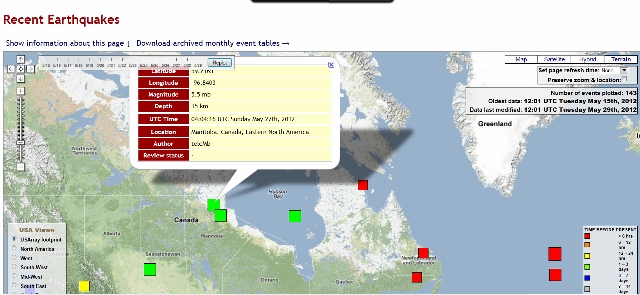
I have many more as well. They all have happened since May 1st of this year.
www.earthquakescanada.nrcan.gc.ca...
I have many more as well. They all have happened since May 1st of this year.
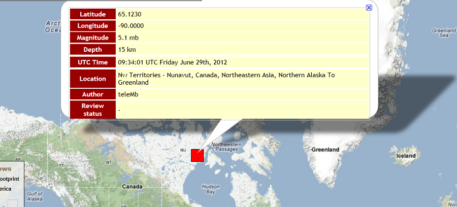
Another earthquake has disappeared from all the earthquake reporting sites.
Don't forget in order for an earthquake to be plotted on a map, that is the epicenter pinpointed, at least THREE seismographs, sometimes thousands of miles apart, had to have received and recorded the same earthquake waves in order to perform triangulation calculations. And what are the chances of three seismographs, hundreds or thousands of miles apart, having the identical error at the same time? Virtually nil.
Don't forget in order for an earthquake to be plotted on a map, that is the epicenter pinpointed, at least THREE seismographs, sometimes thousands of miles apart, had to have received and recorded the same earthquake waves in order to perform triangulation calculations. And what are the chances of three seismographs, hundreds or thousands of miles apart, having the identical error at the same time? Virtually nil.
Originally posted by PlanetXisHERE
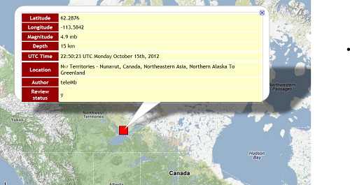
Another earthquake has disappeared from all the earthquake reporting sites.
Don't forget in order for an earthquake to be plotted on a map, that is the epicenter pinpointed, at least THREE seismographs, sometimes thousands of miles apart, had to have received and recorded the same earthquake waves in order to perform triangulation calculations. And what are the chances of three seismographs, hundreds or thousands of miles apart, having the identical error at the same time? Virtually nil.
Thinking outside the box here bare with me
Russia explosion maybe a meteor hit
and this one www.abovetopsecret.com...&addstar=1&on=15165021#pid15165021
lunarmeteoritehunters.blogspot.ca...
also a big meteor over UK
thei been a few reported over canada to
their are being remove becauce their not EQ there meteor hit but are not saying so or reported as so
edit on 17-10-2012 by
Trillium because: (no reason given)
reply to post by PlanetXisHERE
Not only do you see fit to insult TA by suggesting that he should learn about earthquakes, and try and teach me about how earthquakes are located when I was probably looking at this before you were born, but you persist in saying that earthquakes cannot be a mistake if they are picked up by 3 stations.
Unfortunately you have absolutely no idea what you are talking about despite your pontifications and assumed knowledge. The systems not only can but do promulgate earthquakes because the systems are automatic and run by computers, and computers are stupid. They also to not need three stations to make an error - and if you see below in this instance we are talking about 8 in an array.
Your latest 'removal' was never an earthquake, which if you had bothered to look you would have found out for yourself. I suspect however that you don't actually know how to do that.
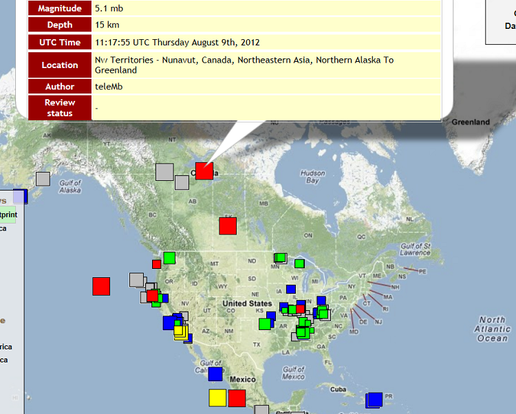
The event to which you refer on 16th October was closest to the Canadian network YKB array, ~8 instruments with the SHZ/E/N channels available to us.
I have demonstrated in my earlier post, if you follow the links to my blog where I explain the effect of transmission breaks on automated systems, that computers can get it wrong. A set of traces from that array at the time you show immediately makes it obvious that the reported quake was an error occasioned by a transmission failure - in fact several!
A little more checking on your part before mouthing off might go a long way to allaying the fears of people who do not have knowledge of the subject and who get worried by unsubstantiated reporting such as yours.
Not only do you see fit to insult TA by suggesting that he should learn about earthquakes, and try and teach me about how earthquakes are located when I was probably looking at this before you were born, but you persist in saying that earthquakes cannot be a mistake if they are picked up by 3 stations.
Unfortunately you have absolutely no idea what you are talking about despite your pontifications and assumed knowledge. The systems not only can but do promulgate earthquakes because the systems are automatic and run by computers, and computers are stupid. They also to not need three stations to make an error - and if you see below in this instance we are talking about 8 in an array.
Your latest 'removal' was never an earthquake, which if you had bothered to look you would have found out for yourself. I suspect however that you don't actually know how to do that.
The event to which you refer on 16th October was closest to the Canadian network YKB array, ~8 instruments with the SHZ/E/N channels available to us.
I have demonstrated in my earlier post, if you follow the links to my blog where I explain the effect of transmission breaks on automated systems, that computers can get it wrong. A set of traces from that array at the time you show immediately makes it obvious that the reported quake was an error occasioned by a transmission failure - in fact several!
A little more checking on your part before mouthing off might go a long way to allaying the fears of people who do not have knowledge of the subject and who get worried by unsubstantiated reporting such as yours.
Hope this is not so
seeing a uptick in meteor sightings. This planet is about to pass through the most meteor dense part of our galaxy, the glactic plane.
seeing a uptick in meteor sightings. This planet is about to pass through the most meteor dense part of our galaxy, the glactic plane.
Here's a radiation spike in Arkansas, where (says the person producing the video) the official radiation information has gone blank:
______beforeitsnews/weather/2013/01/radioactive-sleetsnow-fall-arkansas-why-no-official-warnings-2438806.html
More disappearing or nonappearing (on other sites) earthquakes.
This site, according to some, has hundred of recording errors, yet if you understand seismic reporting you know that at least three independent seismic monitoring stations, must receive the same wave before a geographic plot of the epicenter can be made. How can there be so many mistakes? Why is this earthquake monitoring site still online if its data is so unreliable?
This site, according to some, has hundred of recording errors, yet if you understand seismic reporting you know that at least three independent seismic monitoring stations, must receive the same wave before a geographic plot of the epicenter can be made. How can there be so many mistakes? Why is this earthquake monitoring site still online if its data is so unreliable?
new topics
-
President BIDEN's FBI Raided Donald Trump's Florida Home for OBAMA-NORTH KOREA Documents.
Political Conspiracies: 4 hours ago -
Maestro Benedetto
Literature: 6 hours ago -
Is AI Better Than the Hollywood Elite?
Movies: 6 hours ago -
Las Vegas UFO Spotting Teen Traumatized by Demon Creature in Backyard
Aliens and UFOs: 9 hours ago -
2024 Pigeon Forge Rod Run - On the Strip (Video made for you)
Automotive Discussion: 10 hours ago -
Gaza Terrorists Attack US Humanitarian Pier During Construction
Middle East Issues: 10 hours ago -
The functionality of boldening and italics is clunky and no post char limit warning?
ATS Freshman's Forum: 11 hours ago
top topics
-
President BIDEN's FBI Raided Donald Trump's Florida Home for OBAMA-NORTH KOREA Documents.
Political Conspiracies: 4 hours ago, 26 flags -
Krystalnacht on today's most elite Universities?
Social Issues and Civil Unrest: 15 hours ago, 9 flags -
Supreme Court Oral Arguments 4.25.2024 - Are PRESIDENTS IMMUNE From Later Being Prosecuted.
Above Politics: 15 hours ago, 8 flags -
Weinstein's conviction overturned
Mainstream News: 14 hours ago, 8 flags -
Gaza Terrorists Attack US Humanitarian Pier During Construction
Middle East Issues: 10 hours ago, 8 flags -
Massachusetts Drag Queen Leads Young Kids in Free Palestine Chant
Social Issues and Civil Unrest: 12 hours ago, 7 flags -
Las Vegas UFO Spotting Teen Traumatized by Demon Creature in Backyard
Aliens and UFOs: 9 hours ago, 6 flags -
Meadows, Giuliani Among 11 Indicted in Arizona in Latest 2020 Election Subversion Case
Mainstream News: 12 hours ago, 5 flags -
2024 Pigeon Forge Rod Run - On the Strip (Video made for you)
Automotive Discussion: 10 hours ago, 4 flags -
Is AI Better Than the Hollywood Elite?
Movies: 6 hours ago, 3 flags
active topics
-
Supreme Court Oral Arguments 4.25.2024 - Are PRESIDENTS IMMUNE From Later Being Prosecuted.
Above Politics • 90 • : Lumenari -
Las Vegas UFO Spotting Teen Traumatized by Demon Creature in Backyard
Aliens and UFOs • 12 • : KrustyKrab -
Gaza Terrorists Attack US Humanitarian Pier During Construction
Middle East Issues • 28 • : firerescue -
SHORT STORY WRITERS CONTEST -- April 2024 -- TIME -- TIME2024
Short Stories • 23 • : DontTreadOnMe -
President BIDEN's FBI Raided Donald Trump's Florida Home for OBAMA-NORTH KOREA Documents.
Political Conspiracies • 16 • : Astyanax -
Truth Social goes public, be careful not to lose your money
Mainstream News • 130 • : Astyanax -
Is AI Better Than the Hollywood Elite?
Movies • 13 • : Justoneman -
Hate makes for strange bedfellows
US Political Madness • 47 • : 19Bones79 -
-@TH3WH17ERABB17- -Q- ---TIME TO SHOW THE WORLD--- -Part- --44--
Dissecting Disinformation • 689 • : daskakik -
University of Texas Instantly Shuts Down Anti Israel Protests
Education and Media • 265 • : Astrocometus