It looks like you're using an Ad Blocker.
Please white-list or disable AboveTopSecret.com in your ad-blocking tool.
Thank you.
Some features of ATS will be disabled while you continue to use an ad-blocker.

Quake Watch 2012
page: 193share:
Just for the record (because I'm focused on Japan right now)
5 days ago
33 aftershocks according to JMA
interactive map
there may have been more since the 6th UTC, JMA take 5 days to finalize their data
5 days ago
Lat/Long: 29.471 130.691
UTC: 06/08/2012 03:28:21
JST: 06/08/2012 12:28:21
Depth: 56.3km
Mag: 5.3 ML
Location: NEAR AMAMI-OSHIMA ISLAND: (Ryukyu Islands)
Energy Released: 1344.028 tonnes of TNT
Source: JMA unified hypocenter catalog
33 aftershocks according to JMA
interactive map
there may have been more since the 6th UTC, JMA take 5 days to finalize their data
Papua New Guinea just downgraded from 6.3
Data from QVSData program
7+ days as usual.
Magnitude 6+ earthquakes downgraded: 1
Magnitude 5 or 6+ earthquakes upgraded: 0
------------------------------------------------------------------
Downgraded quake
us|b000bldc|?|Thursday, August 02, 2012 09:56:44 UTC|-4.706|153.228|6.1|70.6|?|34km SE of Taron, PNG
Log closed 214248
------------------------------------------------------------------
Data from QVSData program
7+ days as usual.
reply to post by fossy
Hi fossy. Not saying that I am right, but you should perhaps take a look at this before devoting too much precious time to the study of 188.
Phage also did a study of this and came up with several more apparent 'cycles' No doubt if he breezes past he will give you a link. Alternatively track him down and look on his threads.
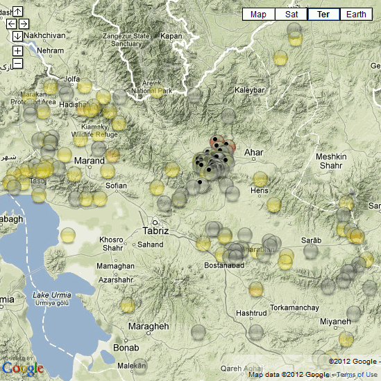
interactive map of Ahar aftershocks to 11/08/2012 20:02:02 UTC
goo.gl...
screenshot

data from International Institute of Earthquake Engineering and Seismology
180 deaths,1300 casualties according to the radio news
ETA: I accidentally downloaded the entire Iranian database since 1901 when searching for 50km radius circle around Ahar historic data, juicy stuff, 14,004 entries above Mag 3.0
Took a bit of sorting, converting UTC to IRDT is a nighmare as the date changes as well as the time for the first and last 3.5hours (4.5hrs IRDT) so ended up just using IRST, well they didn't have IRDT back in 1901 did they
heres the history for the area, sorted by Province which is about 150km radius around todays events.
Not a lot going on above Mag 5 in the past.
I can't use the numbered icons because there are already more than 31 aftershocks (the limit on GMaps), so I have reverted to theoldblackdot to mark those ones in this series.
[url=http://goo.gl/maps/80iaX]interactive Azarbaijan Sharghi history 1907-2012
screenshot
heres the list of the quakes above 5.0 on those maps
WHEN, LAT, LONG, DEPTH, MAG, TYPE, LOCATION, SOURCE
11/08/2012 12:34:35, 38.58, 46.78, 16, 6.1, Mb, Azarbaijan Sharghi, North-West of Ahar, IIEES
11/08/2012 12:23:16, 38.55, 46.87, 15, 6.1, Mb, Azarbaijan Sharghi, West of Ahar, IIEES
02/03/1997 18:29:45, 37.99, 47.89, 15, 5.3, Mw, Azarbaijan Sharghi, West of Nir, EHB
12/05/1931 10:25:15, 38.79, 45.72, 33, 5.2, Ms, Azarbaijan Sharghi, South of Jolfa, NAB
24/08/1984 11:31:41, 38.5, 45.95, 10, 5.1, mb, Azarbaijan Sharghi, East of Marand, ISC
10/02/1965 16:09:54, 37.66, 47.09, 45, 5.0, mb, Azarbaijan Sharghi, North of Hashtrud, ISC
12/11/1913 04:28:56, 38.8, 45.8, 25, 5.0, Ms, Azarbaijan Sharghi, South-East of Jolfa, MEA
goo.gl...
screenshot
data from International Institute of Earthquake Engineering and Seismology
180 deaths,1300 casualties according to the radio news
ETA: I accidentally downloaded the entire Iranian database since 1901 when searching for 50km radius circle around Ahar historic data, juicy stuff, 14,004 entries above Mag 3.0
Took a bit of sorting, converting UTC to IRDT is a nighmare as the date changes as well as the time for the first and last 3.5hours (4.5hrs IRDT) so ended up just using IRST, well they didn't have IRDT back in 1901 did they
heres the history for the area, sorted by Province which is about 150km radius around todays events.
Not a lot going on above Mag 5 in the past.
I can't use the numbered icons because there are already more than 31 aftershocks (the limit on GMaps), so I have reverted to theoldblackdot to mark those ones in this series.
[url=http://goo.gl/maps/80iaX]interactive Azarbaijan Sharghi history 1907-2012
screenshot
heres the list of the quakes above 5.0 on those maps
WHEN, LAT, LONG, DEPTH, MAG, TYPE, LOCATION, SOURCE
11/08/2012 12:34:35, 38.58, 46.78, 16, 6.1, Mb, Azarbaijan Sharghi, North-West of Ahar, IIEES
11/08/2012 12:23:16, 38.55, 46.87, 15, 6.1, Mb, Azarbaijan Sharghi, West of Ahar, IIEES
02/03/1997 18:29:45, 37.99, 47.89, 15, 5.3, Mw, Azarbaijan Sharghi, West of Nir, EHB
12/05/1931 10:25:15, 38.79, 45.72, 33, 5.2, Ms, Azarbaijan Sharghi, South of Jolfa, NAB
24/08/1984 11:31:41, 38.5, 45.95, 10, 5.1, mb, Azarbaijan Sharghi, East of Marand, ISC
10/02/1965 16:09:54, 37.66, 47.09, 45, 5.0, mb, Azarbaijan Sharghi, North of Hashtrud, ISC
12/11/1913 04:28:56, 38.8, 45.8, 25, 5.0, Ms, Azarbaijan Sharghi, South-East of Jolfa, MEA
edit on 11-8-2012 by muzzy because: (no reason given)
Originally posted by fossy
Well, unless any quakes of significant size appear before then, I have predicted that the 19th of August will be the next date when something big appears.
This theory of course has no founding, only the 188 day theory has influenced my predictions.
not to generate any more debate on the "188 days" issue, it's not due until Sept 25th 2012 ... just sayin'...
ooopsydaisy on post by muzzy
missed the end tag on the 2nd interactive link, too late to edit it now (stupid ATS restriction, because most of the time its spelling or formatting that is the reason to edit it)
interactive Azarbaijan Sharghi history 1907-2012
missed the end tag on the 2nd interactive link, too late to edit it now (stupid ATS restriction, because most of the time its spelling or formatting that is the reason to edit it)
interactive Azarbaijan Sharghi history 1907-2012
These Ahar quakes related to the Van, Turkey quake last year maybe?
only 300km away
I been reading about historic Syrian quakes geez its amazing the devastation they've had over the years whole cities destroyed over and over Antioch mainly and Allepo, every couple of years back in the period 0-1000AD seems like the faults were swallowing whole towns up the people never seen again.
Probably the same in Iran too.
reply to post by muzzy
does that map correctly show all fault lines in the area or are those quakes just in the middle of a plate?
BTW thanks for all the great mapping WOW the work put into that .
does that map correctly show all fault lines in the area or are those quakes just in the middle of a plate?
BTW thanks for all the great mapping WOW the work put into that .
reply to post by muzzy
And Erev Yom Kippur this year as well!
You may be right about those Turkish quakes, especially if the focal planes match up.
One of the big things about anything that we say about earthquakes like "unprecedented", "never happened before", even "rare", is that it is all very relative. With recorded history being a few microseconds in the 24 hours of earth's existence it is not possible to make such statements.
Each 1000th of a second represents 52 years if we accept that the Earth is 4.5 billion years old. Written history @ ~3,500 years is a scant 67 micro seconds (just 67/1000 ths of a second)
One second is 52,000 years yet that is only 1/86400 th of the Earth's day.
If I am lucky I will live for 2 whole microseconds. It is sobering, yet we pontificate about what is 'normal'?
reply to post by -W1LL
This image shows the fault systems in Iran
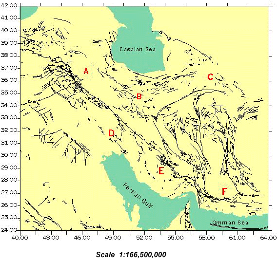
Source: Somewhere on the Iranian Seismic Service site.
I have not overlain the map on the earthquakes to see if there is a fit, but as you can see Iran is heavily faulted.
Here you go - a very quick and not quite perfect job.
This image shows the fault systems in Iran
Source: Somewhere on the Iranian Seismic Service site.
I have not overlain the map on the earthquakes to see if there is a fit, but as you can see Iran is heavily faulted.
Here you go - a very quick and not quite perfect job.
edit on 12/8/2012 by PuterMan because: (no reason given)
Really wish I wasn't up this early... 6.3 China
earthquake.usgs.gov...
Magnitude 6.3
Date-Time
Sunday, August 12, 2012 at 10:47:06 UTC
Sunday, August 12, 2012 at 06:47:06 PM at epicenter
Location 35.673°N, 82.535°E
Depth 9.7 km (6.0 miles)
Region XINJIANG-XIZANG BORDER REGION
Distances 282 km (175 miles) ESE of Hotan, China
481 km (298 miles) ENE of Leh, India
549 km (341 miles) SSE of Aral, China
560 km (347 miles) ESE of Shache, China
Location Uncertainty horizontal +/- 14.2 km (8.8 miles); depth +/- 4 km (2.5 miles)
Parameters NST=354, Nph=355, Dmin=>999 km, Rmss=0.78 sec, Gp= 29°,
M-type=regional moment magnitude (Mw), Version=7
Source
Magnitude: USGS NEIC (WDCS-D)
Location: USGS NEIC (WDCS-D)
Event ID usb000bv81
Originally posted by -W1LL
reply to post by PuterMan
WOWSERS! thanks for that looks like a wrinkly old man
Doesn't it? If you mean F on the fault systems map.
Edited data to avoid duplicates.
edit on 12/8/12 by murkraz because: (no reason given)
Originally posted by TMG333
Really wish I wasn't up this early... 6.3 China
Same here. Didn't see your post as I was typing up PuterMan's long ole format.
Originally posted by -W1LL
reply to post by muzzy
does that map correctly show all fault lines in the area or are those quakes just in the middle of a plate?
BTW thanks for all the great mapping WOW the work put into that .
No problem, I'm just pleased there are other people out there who are interested in this stuff, makes it worthwhile, making the maps is relatively easy, its the processing the data that takes the time. At least now I have the Iranian database converted into an Excel file I can use in the future.
I see Puterman did a couple of maps with the faults on them , looks like these quakes and the aftershocks are at right angles to the main faults.
I di away with the blackdots after that, looked like black eyed peas
Originally posted by PuterMan
reply to post by muzzy
You may be right about those Turkish quakes, especially if the focal planes match up.
I haven't got the time this Monday morning to find out what you mean by "focal plane", but the moment tensor solutions are all different (I used Geofon), even the two Iranian quakes have different beachballs

I haven't looked at USGS MTS's yet to compare, maybe when GCMT come out with the latest quake data it will be worth another look
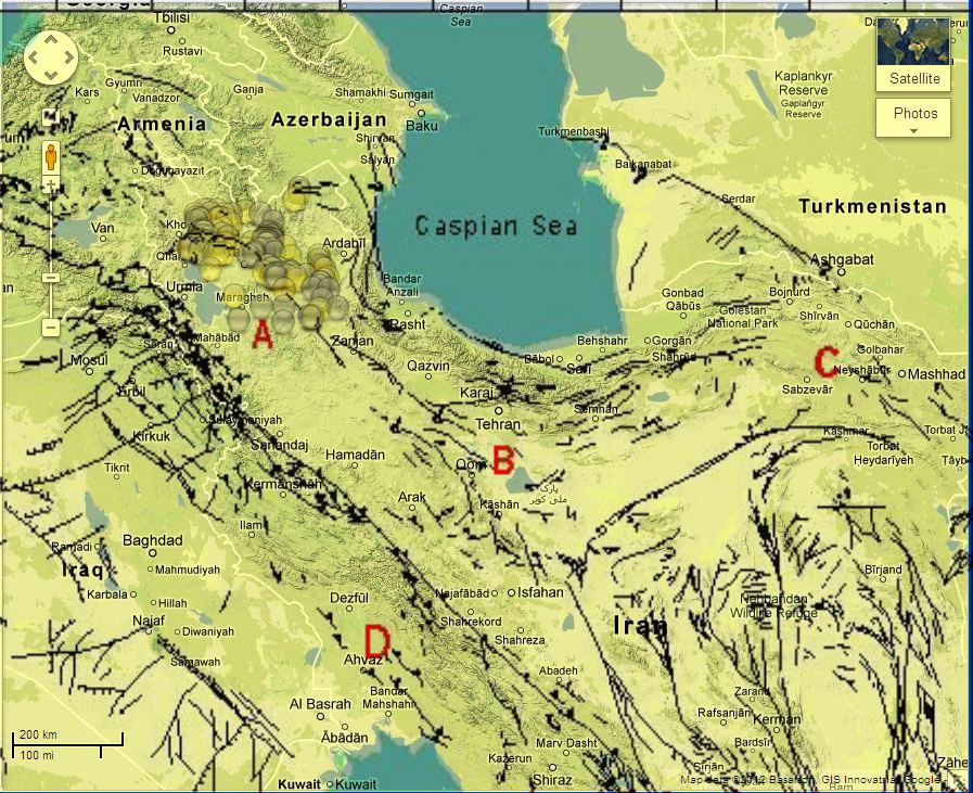
update on Ahar, Iran aftershocks, 122 so far to 13/08/2012 21:38:42 UTC
interactive map
did it in a bit of a rush and screwed up the local times and lost the depths, but UTC and mags are on the popup tags for now. I'll probably do a page on eqarchives after the 72 hour period is up, with a timeline graph (marble spill) and fix all that.
I've marked the RAS locations for the mag 6's as purple icons, they are a bit south of the Iranian locations, and as it happens closer to the faults Puterman showed on those maps yesterday.
The gridlike pattern is due to only 2 decimal point numbers on the Iranian data.
screenshot

308 fatalities counted so far (including 219 woman and children) according to earthquake report.com
interactive map
did it in a bit of a rush and screwed up the local times and lost the depths, but UTC and mags are on the popup tags for now. I'll probably do a page on eqarchives after the 72 hour period is up, with a timeline graph (marble spill) and fix all that.
I've marked the RAS locations for the mag 6's as purple icons, they are a bit south of the Iranian locations, and as it happens closer to the faults Puterman showed on those maps yesterday.
The gridlike pattern is due to only 2 decimal point numbers on the Iranian data.
screenshot
308 fatalities counted so far (including 219 woman and children) according to earthquake report.com
reply to post by muzzy
Hi Guys,
I've replied to muzzy so this ends up at the bottom of the thread. I only really lurk here but love what's discussed etc and appreciate all the stunning work that's done (particularly Puterman & Muzzy)
I was wondering if somebody could explain how a earthquake can register as with a depth of 1 metre. I use the quakes app on my phone and the depth is actually 0.1 km, although on the info I copy/pasted it says 0.
Apologies if I've asked what has previously been answered.
Cheers
Jd
A 3.5 magnitude earthquake occurred in "Central California" (Longitude: -117.672°, Latitude: 35.948°, Depth: 0 meters) on 13 Aug 2012 14:03:47 UTC.
Find out more:
earthquake.usgs.gov...
Composed with Quakes by TAWCS (tawcs.com...)
i just wanted to throw out there that Alaskas recent EQ's seem to be moving inland....this worries me a little. If you look at the map as a whole
there are specific areas in the last 2 weeks that are seemingly more active than usual. Don't want to fear monger but I get the distinct feeling
something is brewing.
reply to post by JediDawn
thanks for the compliment
usually 0km come up where the quake is under a volcano.
In this case its the China Lake Naval Weapons Center so could have been a big explosion.Who knows what they are testing under those hills, there are roads (tracks) running right by the location, perhaps there are tunnels under there.
new topics
-
Need help understanding the evolution of WHO as a power structure. Shades of the NWO...?
New World Order: 1 hours ago -
The geography of Eden
Religion, Faith, And Theology: 1 hours ago -
US 'Uniparty' officially throws Christians to the lions...
Conspiracies in Religions: 3 hours ago -
REAL ID now a reality
General Conspiracies: 5 hours ago -
'I couldn't cope with Britain anymore': Kurdish man pays smuggler to return him to France
Social Issues and Civil Unrest: 7 hours ago -
Former Hamas member goes OFF on ‘low grade’ lefty journalist
US Political Madness: 10 hours ago -
An Apple a Day
General Chit Chat: 10 hours ago -
Oh, Have I got a Goody for You Guys!!!
General Conspiracies: 11 hours ago
top topics
-
Oh, Have I got a Goody for You Guys!!!
General Conspiracies: 11 hours ago, 18 flags -
Former Hamas member goes OFF on ‘low grade’ lefty journalist
US Political Madness: 10 hours ago, 13 flags -
Woman In Her 60s Stabbed To Death In London Street By Thief Who Tried To Steal Her Bag.
Social Issues and Civil Unrest: 13 hours ago, 7 flags -
REAL ID now a reality
General Conspiracies: 5 hours ago, 6 flags -
'I couldn't cope with Britain anymore': Kurdish man pays smuggler to return him to France
Social Issues and Civil Unrest: 7 hours ago, 3 flags -
US 'Uniparty' officially throws Christians to the lions...
Conspiracies in Religions: 3 hours ago, 2 flags -
"The Fool" - A short video featuring a harmonica-playing guy blasted by a UFO
Aliens and UFOs: 16 hours ago, 2 flags -
An Apple a Day
General Chit Chat: 10 hours ago, 2 flags -
The geography of Eden
Religion, Faith, And Theology: 1 hours ago, 1 flags -
Need help understanding the evolution of WHO as a power structure. Shades of the NWO...?
New World Order: 1 hours ago, 0 flags
active topics
-
US 'Uniparty' officially throws Christians to the lions...
Conspiracies in Religions • 13 • : CriticalStinker -
The geography of Eden
Religion, Faith, And Theology • 1 • : TheValeyard -
Multipal Solar Storms Coming Our Way This Weekend
Fragile Earth • 21 • : MemeWithNoN4me -
Judas Iscariot Slips The Hangman's Noose
Political Issues • 48 • : chr0naut -
Democrats have Reduced using the term Bidenomics and Republicans have Increased
2024 Elections • 13 • : RazorV66 -
-@TH3WH17ERABB17- -Q- ---TIME TO SHOW THE WORLD--- -Part- --44--
Dissecting Disinformation • 933 • : daskakik -
Kirkpatrick vs Fugal - Skinwalker ranch briefing.
Aliens and UFOs • 27 • : gort69 -
Thousands of Anti-Semitic People Protest Israel's government in Tel Aviv
Middle East Issues • 73 • : Danvero -
Proof of Cleptocracy
US Political Madness • 28 • : annonentity -
Woman In Her 60s Stabbed To Death In London Street By Thief Who Tried To Steal Her Bag.
Social Issues and Civil Unrest • 27 • : DBCowboy