It looks like you're using an Ad Blocker.
Please white-list or disable AboveTopSecret.com in your ad-blocking tool.
Thank you.
Some features of ATS will be disabled while you continue to use an ad-blocker.

Lunar Reconnaissance Orbiter - Will we finally see the Moon Base?
page: 9share:
Originally posted by Phage No airplanes on the Moon.
True only space shuttles


The photos on Google Earth which show cars (and my house) are aerial photographs taken from airplanes
As to your continued 'myth propagation' of pictures from airplanes are you then claiming that Ikonos is LYING that their images are taken from SATELLITE not AIRPLANES?
Does Google Earth not use Ikonos/Geo Eye data for Google Earth?
Sure street views are not from satellite but quite frankly between you and ArMaP continually stating "Its from airplanes, not satellite" make one curious at motive to keep pushing that
Any one that has done the slightest research knows what half meter resolution looks like from Earth satellites worth their salt
[atsimg]http://files.abovetopsecret.com/images/member/be57797c37d6.png[/atsimg]
www.geoeye.com...
And this is commercial, not military
Does not compare much with THIS, does it?

[edit on 18-7-2009 by zorgon]
reply to post by zorgon
I don't know. Do they? I haven't seen any images labeled as such. What I see is that the clearest images are from DigitalGlobe, providers of fine aerial photography.
Does Google Earth not use Ikonos/Geo Eye data for Google Earth?
I don't know. Do they? I haven't seen any images labeled as such. What I see is that the clearest images are from DigitalGlobe, providers of fine aerial photography.
reply to post by zorgon
To give you an idea of what you're talking about:
GeoEye resolution: .41 meter panchromatic, 1.65 meter multispectral.
www.gd-ais.com...
The LROC image has a resolution of 1 meter. When it reaches its final altitude it will be .5 meter.
Now find an object about the size of the lander in the GeoEye image. They say it has a resolution of .5 meters so you're looking for something about 6 pixels across.
[edit on 7/18/2009 by Phage]
And this is commercial, not military
Does not compare much with THIS, does it?
To give you an idea of what you're talking about:
GeoEye resolution: .41 meter panchromatic, 1.65 meter multispectral.
www.gd-ais.com...
The LROC image has a resolution of 1 meter. When it reaches its final altitude it will be .5 meter.
Now find an object about the size of the lander in the GeoEye image. They say it has a resolution of .5 meters so you're looking for something about 6 pixels across.
[edit on 7/18/2009 by Phage]
Originally posted by Phage
reply to post by zorgon
And this is commercial, not military
Does not compare much with THIS, does it?
To give you an idea of what you're talking about:
GeoEye resolution: .41 meter panchromatic, 1.65 meter multispectral.
www.gd-ais.com...
The LROC image has a resolution of 1 meter. When it reaches its final altitude it will be .5 meter.
Now find an object about the size of the lander in the GeoEye image. They say it has a resolution of .5 meters so you're looking for something about 6 pixels across.
If we send geoeye or ikonos around the moon we'll see all that has to be seen, and in true color, not pathetic greyscale.
End of discussion.
Google, save us!
Ah, and it seems to me that a satellite can be put in a 100km or so orbit around the moon, but i think geoeye and ikonos circles a lot higher on earth, rrrright?
Can we start a petition for google to have their own moon satellite?
[edit on 18-7-2009 by mystr]
Originally posted by mystr
If we send geoeye or ikonos around the moon we'll see all that has to be seen, and in true color, not pathetic greyscale.
End of discussion.
Ikonos released one image of the moon then said short and sweet "We will not be imaging the moon anymore" in a press release
Big Picture
Originally posted by zorgon
Originally posted by mystr
If we send geoeye or ikonos around the moon we'll see all that has to be seen, and in true color, not pathetic greyscale.
End of discussion.
Ikonos released one image of the moon then said short and sweet "We will not be imaging the moon anymore" in a press release
Big Picture
It seems clear that the moon is a forbidden place... How much more than normal will cost to send a "geoeye-moon"?
[edit on 19-7-2009 by mystr]
Originally posted by mystr
If we send geoeye or ikonos around the moon we'll see all that has to be seen, and in true color, not pathetic greyscale.
Didn't you noticed that the resolution is almost the same (0.4 metres for GeoEye-1 and 0.5 metres for LROC)?
And GeoEye-1 photos at that resolution are not true colour, they are panchromatic (greyscale, but sensitive to full visible spectrum) photos.
The problem is that to have high resolutions the cameras can not use different filters, so high resolution cameras are usually monochromatic, even if they are sensitive to all of the visible light, giving us greyscale photos. That is also why they have to use several sensors to have high-resolution colour images, if each sensor is sensitive to a specific wavelength they can make colour images by adding the images from each camera, but is much more expensive, and the reason why most (if not all) high-resolution colour photos from satellites are composites of a high-resolution greyscale photo with the colours from the lower resolution colour camera used just to "paint" the colours over the greyscale photo, resulting in a high-resolution photo in which the colours "bleed" a little over their original positions.
Yes, but the cameras do not have to be as immune to radiation as the ones that leave the Earth and pass all the time in a more harsh environment, Earth satellites "live" bellow the Van Allen belts, so they are much more protected from the solar and cosmic radiation.
Ah, and it seems to me that a satellite can be put in a 100km or so orbit around the moon, but i think geoeye and ikonos circles a lot higher on earth, rrrright?
Satellites orbiting the Moon are more affected by solar radiation than the ones orbiting Mars, for example, because they are much closer to the source of radiation.
Why should they have a Moon satellite? They do not have any Earth satellite either (although most people think that have, and the most ignorant even think that the images are in real time).
Can we start a petition for google to have their own moon satellite?
PS: It's funny that some people say that the astronauts could not go to the Moon because of the radiation, but expect the equipment to be immune to it.
Edited to add a link to a satellite image from GeoEye-1 with a resolution of 0.5 metres per pixel.
And another of an aerial photo with a resolution of 0.15 metres per pixel.
[edit on 19/7/2009 by ArMaP]
Originally posted by zorgon
Does not compare much with THIS, does it?
]
Just rocks and shadows dude - hehe I've always wanted to say that!
Originally posted by ArMaP
Didn't you noticed that the resolution is almost the same (0.4 metres for GeoEye-1 and 0.5 metres for LROC)?
And GeoEye-1 photos at that resolution are not true colour, they are panchromatic (greyscale, but sensitive to full visible spectrum) photos.
The problem is that to have high resolutions the cameras can not use different filters, so high resolution cameras are usually monochromatic, even if they are sensitive to all of the visible light, giving us greyscale photos. That is also why they have to use several sensors to have high-resolution colour images, if each sensor is sensitive to a specific wavelength they can make colour images by adding the images from each camera, but is much more expensive, and the reason why most (if not all) high-resolution colour photos from satellites are composites of a high-resolution greyscale photo with the colours from the lower resolution colour camera used just to "paint" the colours over the greyscale photo, resulting in a high-resolution photo in which the colours "bleed" a little over their original positions.
Yes, but the cameras do not have to be as immune to radiation as the ones that leave the Earth and pass all the time in a more harsh environment, Earth satellites "live" bellow the Van Allen belts, so they are much more protected from the solar and cosmic radiation.
Satellites orbiting the Moon are more affected by solar radiation than the ones orbiting Mars, for example, because they are much closer to the source of radiation.
Why should they have a Moon satellite? They do not have any Earth satellite either (although most people think that have, and the most ignorant even think that the images are in real time).
PS: It's funny that some people say that the astronauts could not go to the Moon because of the radiation, but expect the equipment to be immune to it.
Excuse me, but i've never seen so much excuses all together in one time.
You can apply for a public-relation job at nasa!
Originally posted by ArMaP
And another of an aerial photo with a resolution of 0.15 metres per pixel.
Satellites with balls can do better than this.
[edit on 19-7-2009 by mystr]
Excuses?
Originally posted by mystr
Excuse me, but i've never seen so much excuses alltoghether in one time.
You can apply for a public-relation job at nasa!
I thought they were explanations. Well, I hope at least someone has learnt something with my post, even if it had no effect in you.
And no, I am not interested in public-relations, in fact I hate them, apparently they are incompatible with truth, and I prefer truth.
What do you mean by that?
Satellites with balls can do better than this.
Originally posted by mystr
It seems clear that the moon is a forbidden place... How much more than normal will cost to send a "geoeye-moon"?
Well how many million viewers does ATS have? Have them send us just $5.00 each and we will take that money to Robert Bigelow and see if we can get him to send a small ship for us. I am sure his dislike for NASA, support of UFOlogy and his penchant for exploring odd stuff... this would appeal to his interest. Since he launches from Russia there should be no interference
Originally posted by ArMaP
Didn't you noticed that the resolution is almost the same (0.4 metres for GeoEye-1 and 0.5 metres for LROC)?
Yes I DID notice that which is why I posted the beautiful color image of Boston Harbour where I can clearly see the tall ships in all their splendor and even see small cars and boats that I can easily recognize as small cars and boats
And that does NOT compare to what I see in LRO images of a rock with shadows
And GeoEye-1 photos at that resolution are not true colour, they are panchromatic (greyscale, but sensitive to full visible spectrum) photos.
You do seem to have a fixation with the 'not true colour' thing... The geoeye image... does it not appear to your eyes as the scene would if you saw it yourself? Do Geoeye images not appear in normal color as most people are used to seeing in real life? I fail to see the purpose of nit picking this 'true color' business. Seems like a red herring to me
The geoeye images portray color as we would expect it to be... just as those claiming these Apollo rocks with shadows MUST be spacecraft because we expect them to be there... yet even Phage admits that without this expectation they would in fact "look like rocks"
The problem is that to have high resolutions the cameras can not use different filters, so high resolution cameras are usually monochromatic, even if they are sensitive to all of the visible light, giving us greyscale photos. That is also why they have to use several sensors to have high-resolution colour images, if each sensor is sensitive to a specific wavelength they can make colour images by adding the images from each camera, but is much more expensive, and the reason why most (if not all) high-resolution colour photos from satellites are composites of a high-resolution greyscale photo with the colours from the lower resolution colour camera used just to "paint" the colours over the greyscale photo, resulting in a high-resolution photo in which the colours "bleed" a little over their original positions.

[edit on 19-7-2009 by zorgon]
As to High-Resolution Cameras in Color
Clementine did it...
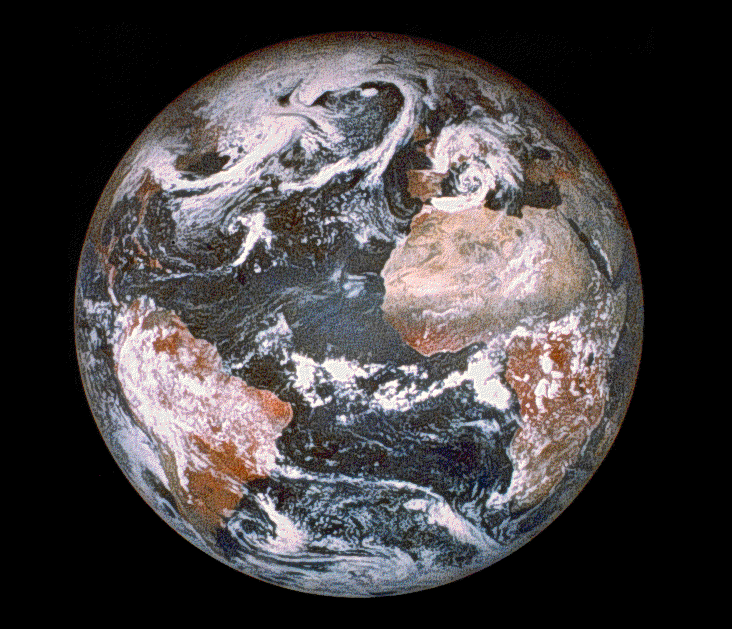
This 1.1-kg camera operates at visible wavelengths (0.415 to 0.75 µm) with silicon CCD technology combined with a compact, lightweight image intensifier. A six-position, spectral filter wheel provided imagery in discrete spectral bands. As an example of the camera's capability, Figure 13 shows an image of Earth taken by the high-resolution camera from lunar orbit at 1250 km above the surface of the Moon and at a distance of 384,000 km from Earth. During the lunar-mapping portion of Clementine, the camera produced high-resolution images for mineral typing of the lunar surface.
www.llnl.gov...
Denial is not a river in Egypt

[edit on 19-7-2009 by zorgon]
Clementine did it...
This 1.1-kg camera operates at visible wavelengths (0.415 to 0.75 µm) with silicon CCD technology combined with a compact, lightweight image intensifier. A six-position, spectral filter wheel provided imagery in discrete spectral bands. As an example of the camera's capability, Figure 13 shows an image of Earth taken by the high-resolution camera from lunar orbit at 1250 km above the surface of the Moon and at a distance of 384,000 km from Earth. During the lunar-mapping portion of Clementine, the camera produced high-resolution images for mineral typing of the lunar surface.
www.llnl.gov...
Denial is not a river in Egypt
[edit on 19-7-2009 by zorgon]
Originally posted by PhageWhat I see is that the clearest images are from DigitalGlobe, providers of fine aerial photography.
It would seem that your sources are incorrect. A simple visit to DigitalGlobe's website and I see nothing about this 'aerial' photography you speak of...
Welcome to DigitalGlobe
The home of the world’s leading provider of high resolution commercial imagery and the only company operating a constellation of sub-meter commercial imaging satellites. The company’s technical superiority and innovation, unparalleled commitment to customer service, extensive business partner network and open systems philosophy make DigitalGlobe the preferred supplier of imagery products to government and commercial markets.
www.digitalglobe.com...
This is one of DigitalGlobe's satellite images...
Featured Image: Kennedy Space Center, Florida | Collected July 15, 2009
So I suspect there is an agenda here pushing the 'airplane' theory
Google Earth Upgrades Images With Geo Eye 1 Satellitewww.marketingshift.com...
Google Earth™ Integration Tools (GeoEye | GeoFUSE N1 v2.1.0)
For our customers that are Google Earth™ users, the Google Earth™ Integration Tools are the perfect solution for quickly locating GeoEye imagery products. ...
geofuse.geoeye.com...
GeoEye: Google Earth Goes High Definition - Associated Content
Oct 23, 2008 ... GeoEye, a geospatial information company, launched GeoEye-1 on September 6, 2008. GeoEye-1 is a new satellite launched from Vandenberg Air ...
www.associatedcontent.com...
Airplanes... you skeptics kill me
That's because LRO is not yet at its working altitude, that is why the resolution is not as high and it changes so much (from 1 to 1.5 metres per pixel) in the photos of the Apollo landing sites.
Originally posted by zorgon
Yes I DID notice that which is why I posted the beautiful color image of Boston Harbour where I can clearly see the tall ships in all their splendor and even see small cars and boats that I can easily recognize as small cars and boats
And that does NOT compare to what I see in LRO images of a rock with shadows
When LRO reaches it's working altitude and starts sending the real mission photos then we can compare them.
No, my post was an answer to mystr, and in the post I was answering he (or she?) talked about true colour, so I used the same expression in my answer.
You do seem to have a fixation with the 'not true colour' thing...
Originally posted by zorgon
Airplanes... you skeptics kill me
I don't know what they use, but looking at the photos in this page, the higher resolution images from Google Earth look more like the ones presented as aerial photos than the ones presented as satellite photos.
PS: see, I didn't talk about colour in this post.
Originally posted by ArMaP
PS: see, I didn't talk about colour in this post.
meh.... that's the problem with working 20 threads on the same topic...
So tell me If I send a Brownie box camera up there with 120 color film... would I get some good images or not
It depends with what mean by "up there".
Originally posted by zorgon
So tell me If I send a Brownie box camera up there with 120 color film... would I get some good images or not
If you go to the space station with that camera I don't see why it would not work, maybe it would get some bright spots on some photos because of higher energy particles (some even affect computers on Earth) passing through the film.
But if you are talking about putting the camera in orbit then, although the camera would survive because of the lack of sensitive parts (the most that could happen would probably be that the mechanism would jam because of the temperature changes), I think the film would not work as it should under conditions that are nothing like the ones for which it was made (unless it was special film made for space photography).
In those harsh conditions, the more low-tech the more possibilities of working, a pin-hole camera will always work, if you have a good film.
reply to post by ArMaP
So all I would need is a few pieces of that miracle insulation they have to keep the Astronauts warm and toasty and safe from radiation and I should be fine. As to the cold I used that Brownie in Winnipeg in winter, 38 below celsius, cold enough to freeze the brass nuts off a monkey (that's a cannon part on medieval ships in case your mind was elsewhere )
Worked fine but you had to take care advancing the film.
Point is with just a little effort I bet I could get a good shot or two of that Moon base on Farside
[edit on 19-7-2009 by zorgon]
I Agree with Zorgon's proposal for funding an ATS satellite!
Regarding this thread, however, posts from some people are reaching 'denial' levels.
And for who it says that LRO photos of apollo sites aren't at their best because because because the spacecraft isn't yet at its optimal altitude: you'll never see photos better that those, would you bet?
And also, regarding for who it says that that the (existing) hi-res clementine's images were published since 2004: find me the appollo landing sites ones, thanks.
[edit on 20-7-2009 by mystr]
new topics
-
Where should Trump hold his next rally
2024 Elections: 2 hours ago -
Shocking Number of Voters are Open to Committing Election Fraud
US Political Madness: 3 hours ago -
Gov Kristi Noem Shot and Killed "Less Than Worthless Dog" and a 'Smelly Goat
2024 Elections: 3 hours ago -
Falkville Robot-Man
Aliens and UFOs: 4 hours ago -
James O’Keefe: I have evidence that exposes the CIA, and it’s on camera.
Whistle Blowers and Leaked Documents: 4 hours ago -
Australian PM says the quiet part out loud - "free speech is a threat to democratic dicourse"...?!
New World Order: 5 hours ago -
Ireland VS Globalists
Social Issues and Civil Unrest: 6 hours ago -
Biden "Happy To Debate Trump"
2024 Elections: 6 hours ago -
RAAF airbase in Roswell, New Mexico is on fire
Aliens and UFOs: 6 hours ago -
What is the white pill?
Philosophy and Metaphysics: 8 hours ago
top topics
-
A Warning to America: 25 Ways the US is Being Destroyed
New World Order: 16 hours ago, 21 flags -
Blast from the past: ATS Review Podcast, 2006: With All Three Amigos
Member PODcasts: 8 hours ago, 13 flags -
James O’Keefe: I have evidence that exposes the CIA, and it’s on camera.
Whistle Blowers and Leaked Documents: 4 hours ago, 12 flags -
Australian PM says the quiet part out loud - "free speech is a threat to democratic dicourse"...?!
New World Order: 5 hours ago, 11 flags -
Biden "Happy To Debate Trump"
2024 Elections: 6 hours ago, 10 flags -
Mike Pinder The Moody Blues R.I.P.
Music: 8 hours ago, 8 flags -
Ireland VS Globalists
Social Issues and Civil Unrest: 6 hours ago, 5 flags -
RAAF airbase in Roswell, New Mexico is on fire
Aliens and UFOs: 6 hours ago, 5 flags -
What is the white pill?
Philosophy and Metaphysics: 8 hours ago, 5 flags -
Putin, Russia and the Great Architects of the Universe
ATS Skunk Works: 12 hours ago, 4 flags
active topics
-
Remember These Attacks When President Trump 2.0 Retribution-Justice Commences.
2024 Elections • 59 • : TzarChasm -
Salvador Dali's Moustaches
People • 29 • : GENERAL EYES -
Mood Music Part VI
Music • 3111 • : TheWoker -
Where should Trump hold his next rally
2024 Elections • 12 • : StudioNada -
University of Texas Instantly Shuts Down Anti Israel Protests
Education and Media • 310 • : SchrodingersRat -
Candidate TRUMP Now Has Crazy Judge JUAN MERCHAN After Him - The Stormy Daniels Hush-Money Case.
Political Conspiracies • 815 • : Annee -
President BIDEN's FBI Raided Donald Trump's Florida Home for OBAMA-NORTH KOREA Documents.
Political Conspiracies • 35 • : Threadbarer -
2024 Pigeon Forge Rod Run - On the Strip (Video made for you)
Automotive Discussion • 8 • : WhitewaterSquirrel -
Gov Kristi Noem Shot and Killed "Less Than Worthless Dog" and a 'Smelly Goat
2024 Elections • 28 • : cherokeetroy -
Shocking Number of Voters are Open to Committing Election Fraud
US Political Madness • 5 • : AwakeNotWoke