It looks like you're using an Ad Blocker.
Please white-list or disable AboveTopSecret.com in your ad-blocking tool.
Thank you.
Some features of ATS will be disabled while you continue to use an ad-blocker.

Mars Image: Building (Pics)
page: 7share:
Hehe Long time no chat Anything new at the Mission I need to know about?
Thanks for the link...
The one I am looking for is Surveyor 1
Kinda looks like THIS

Surveyor 1 - May 30, 1966 - 11,237 images were transmitted to Earth.
Surveyor 3 - April 17, 1967 - 6,315 images were transmitted to Earth.
Surveyor 5 - September 3, 1967 - 19,049 images were transmitted to Earth.
Surveyor 6 - November 7, 1967 - 30,027 images were transmitted to Earth.
Surveyor 7 - January 7, 1968 - 21,091 images were transmitted to Earth.
So far I have about 20 or so images and only two in the high res...
I just got this one from S6 so I know there must be some really awesome ones out there...

Originally posted by rhw007
Which "Surveyor 1" mission are you discussing? Here is list of all pds data sets:
Thanks for the link...
The one I am looking for is Surveyor 1
Kinda looks like THIS
Surveyor 1 - May 30, 1966 - 11,237 images were transmitted to Earth.
Surveyor 3 - April 17, 1967 - 6,315 images were transmitted to Earth.
Surveyor 5 - September 3, 1967 - 19,049 images were transmitted to Earth.
Surveyor 6 - November 7, 1967 - 30,027 images were transmitted to Earth.
Surveyor 7 - January 7, 1968 - 21,091 images were transmitted to Earth.
So far I have about 20 or so images and only two in the high res...
I just got this one from S6 so I know there must be some really awesome ones out there...
Gotta love skeptics. Yep Mars is a different planet, it has different kinds of winds which are capable of creating perfect cubes and pyramids.
Uh huh.
Either the pic is fake or that is not a natural formation, I dont believe in cube shaped rocks on planets. If Mars was littered with cube shaped rocks that might be some kind of explanation, but the fact that majority of the rocks there are as chaotically shaped as the ones on planet earth, kinda makes the natural formation theory kinda hard to swallow.
reply to post by zorgon
These are the only images I have, the first from Surveyor 3 and the other two images from Surveyor 7. They are from that site that you said you were expecting to shut down in last year, remember?


PS: sorry everybody for the off-topic.
These are the only images I have, the first from Surveyor 3 and the other two images from Surveyor 7. They are from that site that you said you were expecting to shut down in last year, remember?
PS: sorry everybody for the off-topic.
Originally posted by unnamedninja I dont believe in cube shaped rocks on planets.
Hehehe I will go with you on that... BUT
The Winds of Barsoom really are ODD
You won't find sand dunes like THIS on Earth

reply to post by unnamedninja
There is more than one way of shaping a rock, and on Mars it looks like the wind is not strong enough to strongly shape large rocks.
Rocks may have their shape given them when they were created (like if the case of the Giants Causeway) or after, and in this case there are many possibilities, including high energy impacts, this photo shows an area inside an impact crater.
Originally posted by ArMaP
These are the only images I have,
Yup got those hehehe 3 out of over 100,000 Not bad its a start!
So back to the block bunker...
I will put a copy on my website as soon as I get some time
Originally posted by ArMaP
high energy impacts,
impacts making a rectangular boulder? and you say I'm crazy
Have we determined how big this is yet?
I didn't said that the impacts had made the rectangular boulder (if it is a rectangular boulder), I was only talking about things that can shape the rocks.
Originally posted by zorgon
impacts making a rectangular boulder? and you say I'm crazy
What, the "building"? Around 3 metres by 2 metres.
Have we determined how big this is yet?
Originally posted by ArMaP
I didn't said that the impacts had made the rectangular boulder (if it is a rectangular boulder), I was only talking about things that can shape the rocks.
Originally posted by zorgon
impacts making a rectangular boulder? and you say I'm crazy
What, the "building"? Around 3 metres by 2 metres.
Have we determined how big this is yet?
What's that in "American" measurements?
Originally posted by Zenagain
Originally posted by ArMaP
I didn't said that the impacts had made the rectangular boulder (if it is a rectangular boulder), I was only talking about things that can shape the rocks.
Originally posted by zorgon
impacts making a rectangular boulder? and you say I'm crazy
What, the "building"? Around 3 metres by 2 metres.
Have we determined how big this is yet?
What's that in "American" measurements?
You mean British Imperial measurements? Ie: Not Metric?
Very odd picture, although if this is a building it seems pretty damn pointless. Why build a small rectangular building in the middle of no where? With no other buildings around or near to it?
reply to post by fatdeeman
Any rock is a monolith.
"Mono", from the Greek "monos" means "single" and "lith", from the Greek "lithos", means "rock", so any rock is a monolith, although it is used more for large rocks.
I hope I have helped you deny your ignorance today.
Any rock is a monolith.
"Mono", from the Greek "monos" means "single" and "lith", from the Greek "lithos", means "rock", so any rock is a monolith, although it is used more for large rocks.
I hope I have helped you deny your ignorance today.
Originally posted by zorgon
Hehe Long time no chat Anything new at the Mission I need to know about?
Originally posted by rhw007
Which "Surveyor 1" mission are you discussing? Here is list of all pds data sets:
Thanks for the link...
The one I am looking for is Surveyor 1
Kinda looks like THIS
(rhw-sniped image)
Surveyor 1 - May 30, 1966 - 11,237 images were transmitted to Earth.
Surveyor 3 - April 17, 1967 - 6,315 images were transmitted to Earth.
Surveyor 5 - September 3, 1967 - 19,049 images were transmitted to Earth.
Surveyor 6 - November 7, 1967 - 30,027 images were transmitted to Earth.
Surveyor 7 - January 7, 1968 - 21,091 images were transmitted to Earth.
So far I have about 20 or so images and only two in the high res...
I just got this one from S6 so I know there must be some really awesome ones out there...
Well I found where ALL Seven are listed:
nssdc.gsfc.nasa.gov...
But GETTING at the data proved EXTREMELY frustrating.
I started with the first and got this page:
nssdc.gsfc.nasa.gov...
Clicked DATA SET and got this page:
nssdc.gsfc.nasa.gov...*
Which NONE of the links will lead you to ACTUAL DATA....
Instead we get "NASA-Speak":
nssdc.gsfc.nasa.gov...
Which means I think you have to "order" the data to be placed "on-line" for digital download...i.e. they have NOT "digitized" the entire library and made it FREELY available to the public.
As always...Never A Straight Answer...or i.e. NEVER a Direct Line to the Data from instrument to the public.
I am way too busy with setting up a couple website sites beside my main site at the bottom, along with keeping up with the MRO images since I was the 1st Cydonia Anomalist to get an iage request in the Mars Quest Fall 2007 Challenge for my Cydonia Smoker. I have another request for the 2008 Spring Mars Quest Challenfe for acquiring the target again only a wee bit west so the COLOR portion covers the "hole/crater" that is so important. Main page for the Smoker and update at the bottom...also they released this image TWICE...once March 5, 2008 with NO "comments" and then again on Friday June 13, 2008 about a week before my Dad died WITH "comments"...both versions are on the update page at the bottom of this one:
commonsensecentral.net...
I am also looking at "Stereo Pairs" for inclusion into Bryce, Lightwave or other 3D software since I have the software to make 3D meshes from these pairs and also to make 3D anaglyphs for 3D perspective whcih is another reason why I want the "Smoker" acquired once more a wee bit west in longitude to become a stereo pair.
If you have luck in getting data "ordered to be put on the server for download" please let me know...I am sure Keith at The Hidden Mission Forum would be interested also.
It may work like the THEMIS IR image processing goes at this link:
thmproc.mars.asu.edu...
Where you put an 'order' in and the THEMIS folks process the data for you and make the results available on-line. I have seen this is other PDS sites as well where you select the data you want....they take some time and tar, rar or zip it...then give you a FTP site to download the data sets.
If you do order, my suggestion would be to do ALL data from one Surveyor mission at time...in ALL formats making sure you use both the OLD names for the data sets and the NEW names shown at the top...so for each of the 5 sets there would be two data IDs, the old original Surveyor 1 data set name and the "new" NSSDC set name.
Hope this helps you.
Bob...
commonsensecentral.net...
Originally posted by GodForbid Why build a small rectangular building in the middle of no where? With no other buildings around or near to it?
I don't know why... maybe we can ask the Nevada Government...

Originally posted by zorgon
Originally posted by GodForbid
Why build a small rectangular building in the middle of no where? With no other buildings around or near to it?
I don't know why... maybe we can ask the Nevada Government...

Pointless? Here's a lone hut that's a workers cabin..
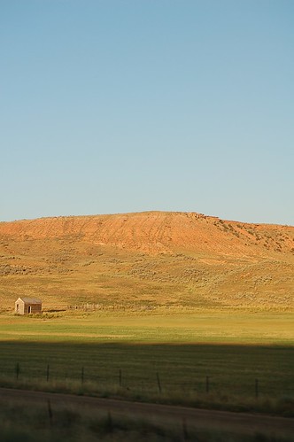
.....Like the one on Mars!
Cheers!
[edit on 12-7-2008 by mikesingh]
I went looking for more rocks with sharp edges and I found some more near the first one.
(I used the Waypoint feature of IASViewer to mark the rocks I found. Also, all the images are from the map-projected version, it is easier to relate the images with the surrounding area this way)
All six rocks are on an relatively small area, marked here in red.
Rocks 1 (the original from the Opening Post) and 2 are near each other.
The other rocks are also near each other.
Seeing that both locations were near rocky outcrops, I went looking for more rocks near rough outcrops, but I could not find other rocks with sharp edges and angles as the rocks from the previous photos.
But I did found two examples of how those sharp edged rocks may have been created, because I found two large rocks breaking along straight lines.
Photo PSP_001415_1875 is not the only photo taken by HiRISE of that area, photo PSP_005714_1875 also covers the eastern part (the one with the "building") of photo PSP_001415_1875, as shown in the following images.
First, the same rocks from photo PSP_001415_1875, as seen on photo PSP_005714_1875.
Some rocks look a bit different because of the difference in the direction of the light, although the directions are not that different.
These are the rocks that I found on image PSP_005714_1875.
This first group in an area more to the east (nearer the rim of the crater).
Near the area from the first photo is where I found most of the sharp edged rocks. As these are a little too far apart to show in one image I decided not to show the individual rocks, it would fill this post even more with images, but if anyone wants me to do it just say so.
This is the area where all these rocks can be found on photo PSP_005714_1875
And this shows that this area is adjacent to the area of photo PSP_001415_1875 where the other rocks were found.
Considering the position of both groups and the fact that these photos are on eastern rim of Mojave crater, maybe there are other rocks like that on other areas of the crater rim (or even on the crater floor), but that must wait for another opportunity.
PS: while looking for sharp edged rocks I have found two other things:
an area for those who like rock tracks
(located here)
and a strange looking area that reminds me of pork ribs. Hmmm, ribs...
(located here)
In conclusion, I am even more convinced that this is just a rock, with an uncommon (in other areas, it looks relatively common in the two photos from this crater's rim) shape.
Edit: I forgot to say that I used a value of 2.200 on the Wavelet Sharpening dialog, it makes the image look better.
[edit on 13/7/2008 by ArMaP]
(I used the Waypoint feature of IASViewer to mark the rocks I found. Also, all the images are from the map-projected version, it is easier to relate the images with the surrounding area this way)

All six rocks are on an relatively small area, marked here in red.

Rocks 1 (the original from the Opening Post) and 2 are near each other.

The other rocks are also near each other.

Seeing that both locations were near rocky outcrops, I went looking for more rocks near rough outcrops, but I could not find other rocks with sharp edges and angles as the rocks from the previous photos.
But I did found two examples of how those sharp edged rocks may have been created, because I found two large rocks breaking along straight lines.


Photo PSP_001415_1875 is not the only photo taken by HiRISE of that area, photo PSP_005714_1875 also covers the eastern part (the one with the "building") of photo PSP_001415_1875, as shown in the following images.


First, the same rocks from photo PSP_001415_1875, as seen on photo PSP_005714_1875.


Some rocks look a bit different because of the difference in the direction of the light, although the directions are not that different.


These are the rocks that I found on image PSP_005714_1875.


This first group in an area more to the east (nearer the rim of the crater).


Near the area from the first photo is where I found most of the sharp edged rocks. As these are a little too far apart to show in one image I decided not to show the individual rocks, it would fill this post even more with images, but if anyone wants me to do it just say so.
This is the area where all these rocks can be found on photo PSP_005714_1875


And this shows that this area is adjacent to the area of photo PSP_001415_1875 where the other rocks were found.

Considering the position of both groups and the fact that these photos are on eastern rim of Mojave crater, maybe there are other rocks like that on other areas of the crater rim (or even on the crater floor), but that must wait for another opportunity.
PS: while looking for sharp edged rocks I have found two other things:
an area for those who like rock tracks
(located here)

and a strange looking area that reminds me of pork ribs. Hmmm, ribs...

(located here)

In conclusion, I am even more convinced that this is just a rock, with an uncommon (in other areas, it looks relatively common in the two photos from this crater's rim) shape.
Edit: I forgot to say that I used a value of 2.200 on the Wavelet Sharpening dialog, it makes the image look better.
[edit on 13/7/2008 by ArMaP]
new topics
-
Only two Navy destroyers currently operational as fleet size hits record low
Military Projects: 9 hours ago
top topics
-
George Stephanopoulos and ABC agree to pay $15 million to settle Trump defamation suit
Mainstream News: 14 hours ago, 17 flags -
Only two Navy destroyers currently operational as fleet size hits record low
Military Projects: 9 hours ago, 7 flags
active topics
-
More Bad News for Labour and Rachel Reeves Stole Christmas from Working Families
Regional Politics • 4 • : gortex -
One out of every 20 Canadians Dies by Euthanasia
Medical Issues & Conspiracies • 25 • : fos613 -
Only two Navy destroyers currently operational as fleet size hits record low
Military Projects • 2 • : Bluntone22 -
They Know
Aliens and UFOs • 89 • : fos613 -
Pelosi injured in Luxembourg
Other Current Events • 37 • : fos613 -
-@TH3WH17ERABB17- -Q- ---TIME TO SHOW THE WORLD--- -Part- --44--
Dissecting Disinformation • 3695 • : RelSciHistItSufi -
Encouraging News Media to be MAGA-PAF Should Be a Top Priority for Trump Admin 2025-2029.
Education and Media • 90 • : Coelacanth55 -
Nov 2024 - Former President Barack Hussein Obama Has Lost His Aura.
US Political Madness • 16 • : Coelacanth55 -
Mood Music Part VI
Music • 3735 • : BrucellaOrchitis -
A Bunch of Maybe Drones Just Flew Across Hillsborough County
Aircraft Projects • 83 • : charlyv