It looks like you're using an Ad Blocker.
Please white-list or disable AboveTopSecret.com in your ad-blocking tool.
Thank you.
Some features of ATS will be disabled while you continue to use an ad-blocker.

Greenwood In UFO Video
page: 17
share:
www.mufoncms.com...
From Mufon >>
June 16 at 9:30 pm. I was looking out of the window from the second floor of my house.I was looking down at the pond when something caught my attention from the corner of my eye.It was a very large brilliant light.This light was moving slow then stopped .Three other lights appeared behind it out of nowhere they looked like they were in a line formation.The lights would then disappear and reappear scattered but close together.They would move all directions up down left and right, then hover but, not all together. They had no formation at this time.I then saw another light appear way up in the sky above the others,it then slowly moved down to the others.This maybe lasted a couple min.I then thought to get my video camera.I ran inside my house got my camcorder then started videotaping. I only got 20 seconds of video ,then they all vanished into thin air but I caught 3 on film just blinking out.Before I started videotaping i counted 5 of these things together .I dont know if you would call these things starlike or spheres.At times they looked like both. They seemed to be hovering and moving over a farm field area from what it looked like.
My friend witnessed these too, he lives a half mile away from me.I don't know what these things are and I don't know whats going on around here in this greenwood area.This is the fifth strange sighting I have had since 2005
Well I dont know..
Prety impressive to my untrained eye.
Im gonna flag this.... needs the pro eye
Mungo
Prety impressive to my untrained eye.
Im gonna flag this.... needs the pro eye
Mungo
Hey BP. Unbelievable. I live in Greenwood. And wouldn't you know that I was up north camping when this happened. My timing is terrible.
I wish they could have recorded more footage. What they did have is interesting to say the least but almost looks like....ok, here I go....flares. Oh, I said it. However, flares certainly don't move around as reported by this person. The only reason I say that is because just south of Greenwood is a military traning base, Camp Atterbury in Edinburgh. It's a training facility for all branches of the military and mobilizes the national guard and reserves and I've seen a few flares being dropped from that area. There has been a ton of activity there after the tornadoes, which hit the base hard and the subsequent floods.
I'm certainly not trying to debunk this, only offering one possible explanation. You know me, BP. You can bet that I'm going to be ats-ing less at night and getting out there to skywatch more. Only thing is that we are in a wooded area so it's not like I can step outside and get a good view. But I will be watching! Well, after I get back, gotta go out of town again. UG
Thanks for posting this. A big S&F from me. I'm so glad that you and others are keeping up with the Indiana sightings.
Rush
Look on the left side above the house that pole has a slow flashing light on it at 12 seconds I paused video and the light is the same as those other
two of subject,the last one is lower,that shows it's further away than the first,their poles in a line (if you lived in the area you would know
this).
This isn't even a hoax it's a video someone found and is trying to make something of it.
Regards
Zelong.
This isn't even a hoax it's a video someone found and is trying to make something of it.
Regards
Zelong.
Originally posted by Zelong
Look on the left side above the house that pole has a slow flashing light on it at 12 seconds I paused video and the light is the same as those other two of subject,the last one is lower,that shows it's further away than the first,their poles in a line (if you lived in the area you would know this).
This isn't even a hoax it's a video someone found and is trying to make something of it.
Regards
Zelong.
With all due respect Zelong, Greenwood is a large town. The tower to the left with the blinking light may be a from the small airport on the eastside of town.
BlackProjects, I would be glad to go check out that area if you can find any details regarding the location. I will be back in town late Monday night. U2U me even if you can get a general area.
Rush
Rush,
Sorry I don't know any more than they posted but according to this some unusual lights were out the following day as well- I posted this on the In thread now it looks like a lot going on in Greenwood >>
Still happening gang..check this account out from www.ufostalker.com... not the Kokomo area..but sounds similar
Case ID: 11204
Log Number: US-06172008-0003
Submitted Date: Tue, 17 Jun 2008 13:27:31 UTC
Event Date: Tue, 17 Jun 2008 01:20:00 UTC
Status: Submitted
City: Greenwood
Region: Indiana
Country: US
Longitude: -86.1238021850586
Latitude: 39.60240173339844
Shape: Fireball,Star-like
Duration: 00:07:00
Distance: Unknown
Location: Suburban
Terrain: Fields
Location Specifics: Airport
Visibility: Clear
Description:
� My buddy was driving home and I was in the passenger seat.� We were between County Line Rd. and Main St, in Greenwood, IN.� We just finished eating dinner with another friend, and we were all heading back home.� Randomly I looked up at the sky from the passenger seat.� I saw two very intense bright amber-colored lights high above the sky.� It looked like they would have been over the city of Frankln or Columbus IN, which are� approx. 7 and 20 miles from Greenwood respectively.� So I was looking South and saw these 2 lights.� Then a third light popped up out of nowhere.� The three got into a clustered group and formed a nearly triangular shape.� � I remember thinking up until then that it was road flares, because that was the only thing that it looked like it could have been(even though the lights appeared from thin air, unlike road flares).� Next four more of these lights showed up out of nowhere, just like the third light.� The seven lights remained clustered, then they formed a diagonal line, very well organized I might add.� This is when I started to get the goosebumps.� After forming the line the seven got back into a spread out clustered formation, and many of them started to blink and flash.� Then they started to disappear.� Amazingly they all reappeared in different parts of the sky fractions of a second after they disappeared.� It was like they were covering miles and miles of skyline in tenths of a second.� They just kept disappearing and reappearing.� I remember how upset we were when they were gone, then we would get really pumped up when they would reappear, it was an amazing sight.� If I had to describe the light I would compare it to the way a large street light looks from a slight distance, however these lights were more intense and had a very high altitude.� � The weird thing was that I called some local news affiliates from Indianapolis, and I kept getting told it was a Marine helicopter training exercise.� Oddly the police department knew nothing about the Marine training exercise. These lights were not helicopters, unless they were helicopters that could disappear and reappear and not make a sound (if you see a helicopter you can hear it).� Also about 45 minutes after the spectacle helicopters started flying right by my apartment southbound, toward the area of the event.� There were approximately 8 choppers total heading down there and they were all low and in a hurry.� Helicopters never fly around like that in my neck of the woods unless its emergency or news choppers.� � Some helpful information I could give would be that there is a small airport 2 miles west from where I first witnessed the lights.� Also there is a military training base (Camp Atterbury) about 20 minutes south from Greenwood IN.� To my knowledge this base does not deal w/ military flight or aviation.� I am a skeptical person and I tend to find rational worldly explanations for everything I hear and see.� What I saw last night was either an extremely advanced form of human aviation, or some other form of aviation that I guess would not be human.� I am not so concerned with it being terrestrial/extraterrestrial, I just want to know how those lights were moving and disappearing/reappearing like that.� Sorry to type so much but I am hoping someone gets on here that was in the same area last night, and can share their story, so I want to be as descriptive as possible.� � In closing I want to say that the way they formed their patterns was odd.� They went from two lights to three lights, and made a triangle.� Then four more appeared and the 7 made a diagonal line.� Then the spread clustering, and the dissappearing/reappearing.� Then it was like they worked back down to finish.� They formed back into a cluster, then a diagonal line, then there were only two left (They left the triangle out at the end).� I'm getting chills right now here at work as I am typing this.� This is my first ever experience with anything like this, and I must say it was the oddest and most fascinating thing I have ever witnessed in my 24 years of existence.
Originally posted by hsur2112
With all due respect Zelong, Greenwood is a large town. The tower to the left with the blinking light may be a from the small airport on the eastside of town.
Rush
Yes excuse me,it was worded a bit hastily.
Air port sounds right,real close too as those flashing beacons a very low,there could be a landing area close by.
Cheers.
Hey BP. Thanks for posting that other sighting. I know exactly where that area is, only about 7 miles east of me. I may have found the 'beacon' as
well, actually about 3 miles from me, but I want to check out the airport too. I'm going to be out and about on Tuesday and Wednesday so I'll see
what I can find.
Rush
Rush
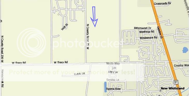
Hey BP. Sorry it took so long to update. I think I found the tower from that video. If it is the same tower, then it's possible that the two separate
reports were viewed in the same general area. In other words, according to the 2nd report that you posted they were looking in the direction of
Franklin/Columbus, looking south. The tower that I located, and from the video, that individual was filming south, in the direction of
Franklin/Columbus (Columbus is south of Franklin). If the times on the reports are correct, there is only about 4 hrs. separating the two.
Here's a pic of the tower that I located. There are three similar towers scattered about, but this is the only one that ties the two incidents and that is in the Greenwood city limit. The subdivision across the street from it where I believe the footage was shot.

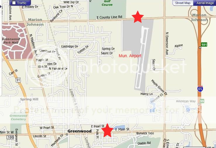
Here's a map of the general area according to the 2nd report that you posted. I starred the two streets he/she mentioned and the airport. Oh, I checked...the tower in the video is not the airport beacon.
Here's the general area where I found the tower almost due south from the location of the 2nd incident that you posted. I shot the picture (above) from the subdivision across the street from it facing south/southeast.
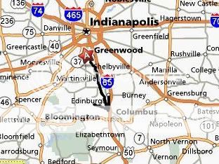
I'm throwing this map out there just to show that the line of sight for each incident is similar. The arrow runs south from Greenwood through Franklin, Columbus and Edinburgh. Which brings up another point, Edinburgh is home to Camp Atterbury.
So, I don't know if any of this helps, but IMHO, both incidents were quite possibly coming from the same area.
Rush
Here's a pic of the tower that I located. There are three similar towers scattered about, but this is the only one that ties the two incidents and that is in the Greenwood city limit. The subdivision across the street from it where I believe the footage was shot.
Here's a map of the general area according to the 2nd report that you posted. I starred the two streets he/she mentioned and the airport. Oh, I checked...the tower in the video is not the airport beacon.
Here's the general area where I found the tower almost due south from the location of the 2nd incident that you posted. I shot the picture (above) from the subdivision across the street from it facing south/southeast.
I'm throwing this map out there just to show that the line of sight for each incident is similar. The arrow runs south from Greenwood through Franklin, Columbus and Edinburgh. Which brings up another point, Edinburgh is home to Camp Atterbury.
So, I don't know if any of this helps, but IMHO, both incidents were quite possibly coming from the same area.
Rush
Hi. I was the one who took the video . sorry i couldnt have gotten more but i guess at least it was something.the video you all saw wasnt that great.
It was transfered to my computer from my handi cam(high8) on an outdated windows movie maker. When I hook it directly up to my tv it looks way
better.and actually clear. you can see more of the extent of them vanishing. I have had 2 retired military people check out the original tape.
These were people who dealt with military aircraft and they have seen alot . but they said they have never seen anything like that .These were not
planes and not flares.The only Thing i ever posted was the video for mufon. I never expected it to end up on you tube or disclose tv.I never called
the news or anything because I really didnt want to.That would be a little too much for me. I just put it on mufon to see what they would say it was.
I just wish you all could have seen what i did before the tape started rolling.
Hi jaycee1 and thank you for taking the time to post this information. Believe me, I wish I could have witnessed this too. And I am intruiged by the
comments from your ex-military contacts.
Just two questions. First, was your sighting to the south towards Franklin/Columbus as the other sighting reported in this thread? And second, were my maps correct as far as general area and line of sight for your sighting?
Rush
[edit on 27-7-2008 by hsur2112]
Just two questions. First, was your sighting to the south towards Franklin/Columbus as the other sighting reported in this thread? And second, were my maps correct as far as general area and line of sight for your sighting?
Rush
[edit on 27-7-2008 by hsur2112]
reply to post by hsur2112
Hi! I was filming on the south side of greenwood the objects were farther south but, it was hard to tell how far south they were because i wasnt sure of the size of the objects . probably whiteland almost franklin area .columbus is to far south.
Hi! I was filming on the south side of greenwood the objects were farther south but, it was hard to tell how far south they were because i wasnt sure of the size of the objects . probably whiteland almost franklin area .columbus is to far south.
reply to post by jaycee1
Hi jaycee1 and thanks for replying. It is an interesting sighting to say the least. I really can't speculate on what was going on here. I have noticed that there has been increased military activity at Camp Atterbury since the spring and I have to wonder if they are related. Indiana has been hopping with sightings this year that's for sure. Except for me......I always seem to be a day late and a dollar short. hehe
Please post if you get any further information or additional sightings.
Rush
Indianapolis International Airport is about 10.8 miles northwest of where this occurred.
The Greenwood Municipal Airport is a single runway, for light aircraft, so it's not like it would have multiple planes stacking up to land. It is about 2.5 miles northeast of the location. In the picture, the runway is on the right, and the taxiway on the left. If I remember right, planes take off and land facing south.
There is a National Guard Armory (Helicopter base, really) about 18 miles to the east by southeast. They fly Blackhawks in and out of there all the time.
Camp Atterbury is about 20 miles south by southeast from the location.
We know the cameraman was facing in a southerly direction, because you can see the reflection of the sunset on the houses.
The towers like the ones pictured do not have non-flashing lights. They have a bright white flashing light. Taller structures will sometimes have a red flashing light, and sometimes a bright white flashing light.
The picture listed is wrong. They have the coords on Main Street. According to Microsoft Streets and Trips, it should be on 900 North. (County Road). This means that the actual place reported is about 1/2 mile south of where the map shows.
It is NOT as close to the "municipal" airport as that picture makes it look.
Years and years ago, they used to fly A-10s out of Atterbury. When I was a kid, I used to see them all the time. Now, you only see a couple maybe once or twice a year.
They aren't towers, I can say that much. My first guess would be planes reflecting the evening sunset. I saw a plane "turn into" an orange-glowing cigar shaped UFO, then back again early one morning from the sunrise. However, the color is wrong in this particular film. But, the way they were just there for a couple of seconds, is similar.
So, I don't know what it was, but I'm positive it wasn't communication towers. It's not apparent from the video (at least not to me) but it looks like they don't really move. If anything, they look like lights for a Tennis Court, or Football field, but Greenwood High School is almost directly east of there (If I remember correctly, and I'm not positive on that one). Whiteland High School would be somewhere in a southern direction from that point. It would be about 2.5 to 3 miles from that point. I suppose someone could figure the height that the light would look to be at that distance.
Just more information for all of you.
Edited to add: One more thing. Columbus is WAY south of Franklin. Taking back roads from where I live, I can be in Franklin or Greenwood in about the same amount of time 15 minutes when I was younger, 20-25 minutes now. It takes about 45 minutes on I-65 south to get to Columbus from Greenwood.
[edit on 28-7-2008 by sir_chancealot]
Hi everyone! hsur2112 you are correct with 75w. that is where the tower is at. As for the video. No planes ever fly that area or at least i havent
ever seen one. About a week after i submitted the story and vid to mufon they contacted me and wanted to talk to me on the phone.I wasnt to fond of
that but, i agreed. and then they wanted to record the telephone call.seems strange,anyway he told me the military were doing some sort of
helicopter training or tests in Indiana. and of course i didnt see any helicopters .I have heard that atterbury activity is higher than usual. I dont
think these things came from atterbury. It wouldnt make sense . Why would they leave atterbury , go invisible ,reappear where i took the vid, put on
a dancing light show then disappear and go back to atterbury. Then again anything is possible, I guess. That day i filmed when they dissapeard I
waited and watched for a long while and nothing . The sky was perfectly clear. I think those things were still there I just couldnt see them.One
other thing I was thinking about. I know the military may have some anti gravity aircraft in test or flight but I just dont think they could do this
yet. I mean who could fly it and if they could fly it unmanned why show off near housing editions where if something went wrong it would be really bad
.Makes no sense.I saw 4 of these in a line formation then, a split second later, scatter, then move all directions while vanishing and reappearing.
Not to mention the single one that came strait down from the sky to join the group which made 5 total. I have never seen anything strange in or next
to atterbury I go fishing at atterbury quite a bit.I have seen other strange things in the sky around here but, this is the only one I have little
proof of.
reply to post by jaycee1
Hi jaycee and thanks for replying. Thanks for verifying the location of the tower. I just wanted to give everyone a general area of where you shot the video and I started with that tower and that is wasn't the source of the lights that you saw and that no other towers were visible in that line of sight.
And you're right. It really doesn't make sense to test such things over populated areas. That's what Kokomo is dealing with as well, and it is making some residents very nervous. My sister-in-law witnessed these lights up north (which I posted in the Indiana thread) and she said that she felt like "they" were taking pictures of them. Weird.
What could we be dealing with? Are the sightings a result of the increased military activity OR is the increased military activity a result of the UFO sightings. And if they are working on some secret anti-gravity thing, why Indiana?
Rush
Hi. I dont think its anything the military is testing out, but one of the retired military men who watched my vid has seen a disk shaped craft the
military has when he was in virginia. He said it was silent and would move all directions , but this is all he saw.Another idea to take is.All this
happened after the flood and earthquake,but then again i saw wierd stuff in 2005 to 2008 so i guess that cancels out the flood earthquake deal.
Probably never will know.
reply to post by jaycee1
Hi jaycee. We will just keep our eyes to the skies. I don't think we've seen the end of the activity around here, pure speculation of course, but I do encourage those members in and around central Indy to keep your eyes open and report any strange activity.
There is a MUFON meeting in Kokomo, on August 16 from 12 - 5 if anyone is interested.
Indiana Mufon
Rush
new topics
-
A Warning to America: 25 Ways the US is Being Destroyed
New World Order: 1 hours ago -
America's Greatest Ally
General Chit Chat: 2 hours ago -
President BIDEN's FBI Raided Donald Trump's Florida Home for OBAMA-NORTH KOREA Documents.
Political Conspiracies: 7 hours ago -
Maestro Benedetto
Literature: 8 hours ago -
Is AI Better Than the Hollywood Elite?
Movies: 9 hours ago
top topics
-
President BIDEN's FBI Raided Donald Trump's Florida Home for OBAMA-NORTH KOREA Documents.
Political Conspiracies: 7 hours ago, 27 flags -
Weinstein's conviction overturned
Mainstream News: 16 hours ago, 8 flags -
Gaza Terrorists Attack US Humanitarian Pier During Construction
Middle East Issues: 13 hours ago, 8 flags -
Massachusetts Drag Queen Leads Young Kids in Free Palestine Chant
Social Issues and Civil Unrest: 15 hours ago, 7 flags -
Las Vegas UFO Spotting Teen Traumatized by Demon Creature in Backyard
Aliens and UFOs: 12 hours ago, 6 flags -
Meadows, Giuliani Among 11 Indicted in Arizona in Latest 2020 Election Subversion Case
Mainstream News: 15 hours ago, 5 flags -
2024 Pigeon Forge Rod Run - On the Strip (Video made for you)
Automotive Discussion: 13 hours ago, 4 flags -
Is AI Better Than the Hollywood Elite?
Movies: 9 hours ago, 3 flags -
A Warning to America: 25 Ways the US is Being Destroyed
New World Order: 1 hours ago, 3 flags -
Maestro Benedetto
Literature: 8 hours ago, 1 flags
active topics
-
New whistleblower Jason Sands speaks on Twitter Spaces last night.
Aliens and UFOs • 65 • : Jukiodone -
HORRIBLE !! Russian Soldier Drinking Own Urine To Survive In Battle
World War Three • 50 • : F2d5thCavv2 -
Russia Ukraine Update Thread - part 3
World War Three • 5732 • : F2d5thCavv2 -
The Acronym Game .. Pt.3
General Chit Chat • 7751 • : F2d5thCavv2 -
Salvador Dali's Moustaches
People • 28 • : zosimov -
Is AI Better Than the Hollywood Elite?
Movies • 17 • : ThePsycheaux -
The best Rice dish i've ever tasted... Kimchi Rice
Food and Cooking • 26 • : lamhaocc -
A Warning to America: 25 Ways the US is Being Destroyed
New World Order • 1 • : 727Sky -
Massachusetts Drag Queen Leads Young Kids in Free Palestine Chant
Social Issues and Civil Unrest • 15 • : tarantulabite1 -
America's Greatest Ally
General Chit Chat • 1 • : BingoMcGoof
7