It looks like you're using an Ad Blocker.
Please white-list or disable AboveTopSecret.com in your ad-blocking tool.
Thank you.
Some features of ATS will be disabled while you continue to use an ad-blocker.

Actual C-130 Interaction With The Pentaplane helps reveal the TRUE flight path.
page: 1share:
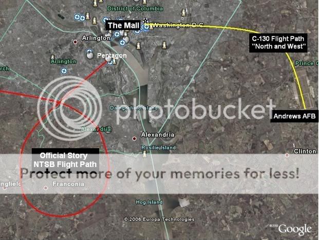
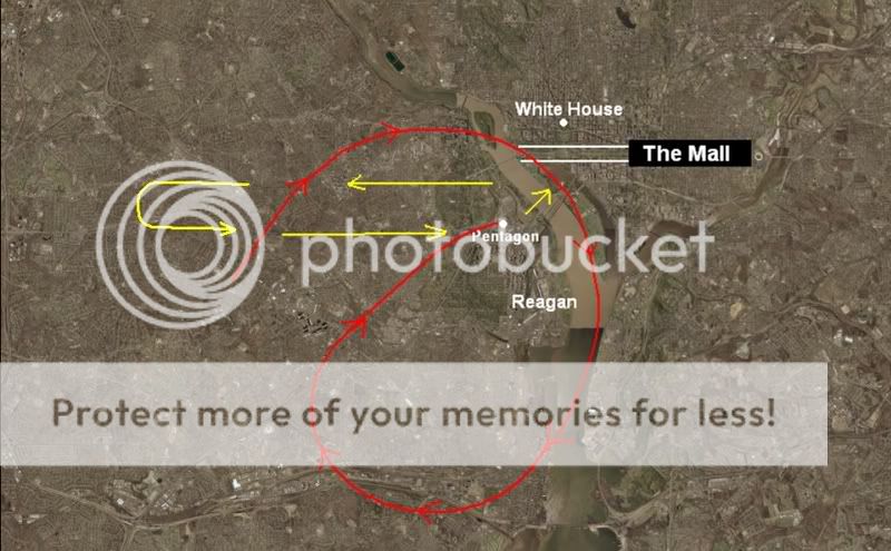
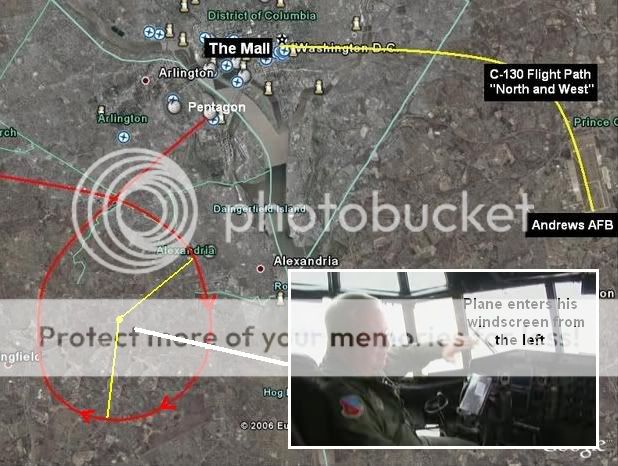
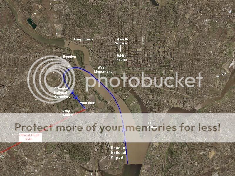
The crew of Gopher 06 took off from Andrews Air Force Base, traveling NORTH AND WEST, which took them by the Washington Mall.
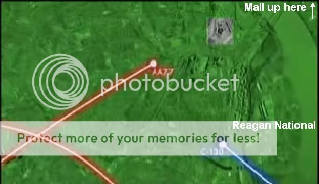
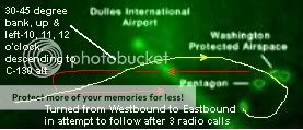
He was on the south side of the Mall and had just passed it going WESTBOUND when he first saw the plane up and to the left(or in front of him) , about 4 miles out, at 10' o'clock/11 O'Clock/12 O'clock in a 30-45 degree bank descending to his altitude. He said it was like "coming up to an intersection" . While O'Brien is traveling WESTBOUND, the plane's traveling EASTBOUND toward him, turning NORTHBOUND and back to EASTBOUND heading while in the 30-45 degree bank. The plane essentially crosses in front of him, flies around/below them heading towards the Potomac/mall/whitehouse or Potomac/Pentagon, then down river near Reagan National before finally turning out of it's bank and to it's final heading toward the Pentagon.
As for when the C-130 turns to follow it, it is after the plane passes them. They have 3 radio calls before turning around to follow it. The C-130 turns from WESTBOUND to EASTBOUND to follow it according to O'brien, essentially doing a U-Turn. By the time he turns around, he see's it Southeast of the white house AND he has a hard time keeping the plane in sight (presumably it was coming out of the spiraled bank turn MILES AWAY near Reagan???). O'Brien sees an explosion on the ground and "did not know what or where it had impacted" implying he is at a high altitude and far away.
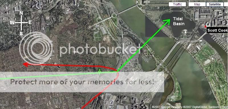
Then, according to a genuine witness on the other side of the river, Scott Cook, he sees the C-130 about 60 seconds after the explosion approaching the Pentagon and see's it start "a steep decent towards the Pentagon. [...] descending at a much steeper angle than most aircraft... the plane reached the Pentagon at a low altitude and made a sharp left turn, passing just north of the plume, and headed straight for the White House. [...] But then right over the tidal basin, at an altitude of less than 1000 feet, it made another sharp left turn to the north and climbed rapidly. "
Here is an image my partner created using Scott Cook's published account and an e-mail correspondence we had with him to establish what we believe he was telling us.:
How we arrived at this:
In another interview,
Although the BBC documentary is completely misleading and confusing regarding his interaction with the plane...
...his account still seems to correspond with what he has ultimately been saying-
he says he took off from Andrews AFB headed north and west to an altitude of 3000 ft to the "south side of the Mall".
Then it cuts to:
Clearly he has the plane entering from the left side of his windscreen ( If O'brien is moving WESTBOUND just past the mall then the plane coming from his left would be going NORTHBOUND like he said). And the event is clearly taking place around or near , or just past the mall.
If that wasn't clear enough. He clarified it for us in an e-mail exchange:
As the plane passes them headed EAST while the C-130 is headed WEST, it continues to bank past them and descend below them, on their right side...
As the plane passes them in it's spiral/descent turn, it is headed from northm to east, to southeast, to southwest...the C-130 continues on WEST without turning around until 3 radio calls later.
Lt. Col. O'Brien explains:
Then before or after he turns around, he presumably saw the plane now southeast of the white house, as this is how he or it is reported:
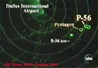
Oddly this is almost EXACTLY what the National Geographic radar tracking shows:
Fits with what we originally thought he was saying...
He tells us he turned back to the east in an ATTEMPT to follow it. So he turned from WEST to EAST, basically doing a U-Turn. He says he had a hard time keeping it in sight, this would make sense since it was 3 radio calls later that he FINALLY turned around. He also states that he "DID NOT KNOW WHAT OR WHERE IT HAD IMPACTED"....
Clearly it was headed east, turned to the northernly heading as it made it's bank/turn east again-turning then to the southern headin. It was north of the Pentagon (clearly since the C-130 was next to the mall and had just past it when he first noticed the plane), over/near the Mall/DC/The Monument/The White House. All of this is near Rosslyn and the USA Today building, which Norman Mineta stated FAA Deputy Director Monte Belger told him the radar track showed it, near Rosslyn/USA Today and coming DRA (Down River Approach) . THIS WOULD SUPPORT O'BRIEN'S DESCRIPTION OF WHAT HAPPENED.
It is clear from a number reports that the plane flew over DC or the Capitol, so we really can't accept that it "had not crossed over towards the White House or towards the Capitol", as Mineta tries to assert.
Then on 9/21/01, they tried changing what really happened
[SIZE=7]The Cover-up:[/SIZE]
Now that we have figured out exactly where the planes were at, they decided to bolster up their phony flight path:
First in Oct. 2001, with the Danielle O'Brien 20/20 interview, they illustrated the phony path:
...and the 911 Commission Hearings animated version, that of course shows the official flight path and the plane on the SOUTH SIDE:
Which of course led to the 2006 release of the NTSB Flight Path Study of "Flight 77":
The problem was, old versions of the original flight path were still floating around, here are two National Geographic versions:
And this one:
Our confusion was always in the flight path of the C-130 bringing it by the Mall and the plane being able to come in from his left hand side of his windscreen, yet this did not jive with the official NTSB flight path:
z9.invisionfree.com...=5665&st=0
Apparently, since we caught on to their crap they actually CHANGED the C-130's story and location, taking him away from THE MALL and placing him flying southwest to meet this phony flight path, and try and make their BS story work.
They apparently also try and support, many of the suspect witnesses' accounts of the C-130 veering away before even reaching the Pentagon.
THIS DID NOT HAPPEN.
Scott Cook described it perfectly.
This jives with the C-130 pilot's accounts and actions. He traveled WEST, then flipped a U and traveled EAST.
Like I mentioned earlier, Kieth Wheelhouse, Joel Sucherman, and a few others have this "second plane", the C-130. veering off in a bank out of there, in a U-Turn to the West. The problem is he obviously didn't do this, is this what the flyover plane would have done?
From AVweb:
Perhaps this was the early stage for the covering up the flyover.
[edit on 29-10-2007 by Craig Ranke CIT]
He was on the south side of the Mall and had just passed it going WESTBOUND when he first saw the plane up and to the left(or in front of him) , about 4 miles out, at 10' o'clock/11 O'Clock/12 O'clock in a 30-45 degree bank descending to his altitude. He said it was like "coming up to an intersection" . While O'Brien is traveling WESTBOUND, the plane's traveling EASTBOUND toward him, turning NORTHBOUND and back to EASTBOUND heading while in the 30-45 degree bank. The plane essentially crosses in front of him, flies around/below them heading towards the Potomac/mall/whitehouse or Potomac/Pentagon, then down river near Reagan National before finally turning out of it's bank and to it's final heading toward the Pentagon.
As for when the C-130 turns to follow it, it is after the plane passes them. They have 3 radio calls before turning around to follow it. The C-130 turns from WESTBOUND to EASTBOUND to follow it according to O'brien, essentially doing a U-Turn. By the time he turns around, he see's it Southeast of the white house AND he has a hard time keeping the plane in sight (presumably it was coming out of the spiraled bank turn MILES AWAY near Reagan???). O'Brien sees an explosion on the ground and "did not know what or where it had impacted" implying he is at a high altitude and far away.
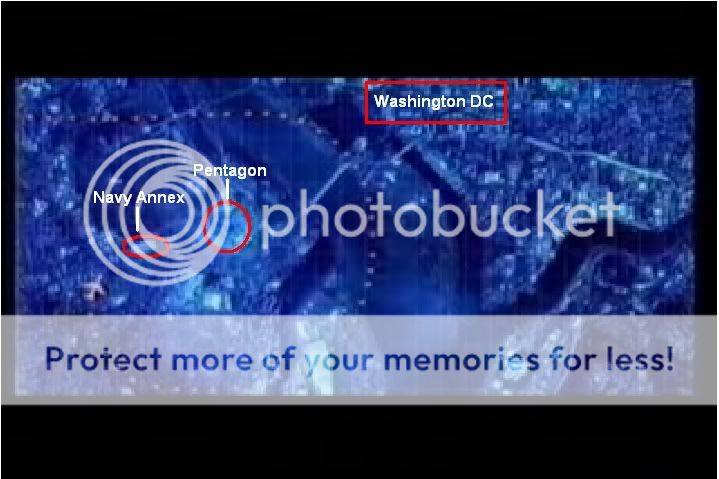
Then, according to a genuine witness on the other side of the river, Scott Cook, he sees the C-130 about 60 seconds after the explosion approaching the Pentagon and see's it start "a steep decent towards the Pentagon. [...] descending at a much steeper angle than most aircraft... the plane reached the Pentagon at a low altitude and made a sharp left turn, passing just north of the plume, and headed straight for the White House. [...] But then right over the tidal basin, at an altitude of less than 1000 feet, it made another sharp left turn to the north and climbed rapidly. "
Here is an image my partner created using Scott Cook's published account and an e-mail correspondence we had with him to establish what we believe he was telling us.:
How we arrived at this:
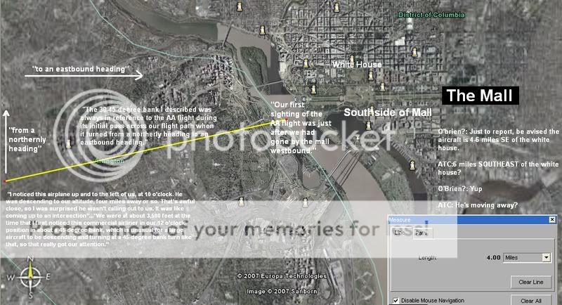
"When we took off, we headed north and west and had a beautiful view of the Mall," he said. "I noticed this airplane up and to the left of us, at 10 o'clock. He was descending to our altitude, four miles away or so. That's awful close, so I was surprised he wasn't calling out to us. It was like coming up to an intersection"
In another interview,
"We were at about 3,500 feet at the time that I first noticed this commercial airliner in our 12 o'clock position in about a 45-degree bank, which is unusual for a large aircraft to be descending and turning at a 45-degree bank turn like that, so that really got our attention."
Although the BBC documentary is completely misleading and confusing regarding his interaction with the plane...
...his account still seems to correspond with what he has ultimately been saying-
he says he took off from Andrews AFB headed north and west to an altitude of 3000 ft to the "south side of the Mall".
Then it cuts to:
"and as he moved to our 11 o' clock position..."
"he started his turn..."
"and by the time he got to our 12 O'clock position, right out the front of the aircraft,"
"uh he was rolled up into 30-40 degrees of bank which is considerable for a commercial airliner."

Clearly he has the plane entering from the left side of his windscreen ( If O'brien is moving WESTBOUND just past the mall then the plane coming from his left would be going NORTHBOUND like he said). And the event is clearly taking place around or near , or just past the mall.
If that wasn't clear enough. He clarified it for us in an e-mail exchange:
Our first sighting of the AA flight was just after we had gone by the mall westbound.
[...]
The 30-45 degree bank I described was always in reference to the AA flight during its initial pass across our flight path when it turned from a northerly heading to an eastbound heading.
As the plane passes them headed EAST while the C-130 is headed WEST, it continues to bank past them and descend below them, on their right side...
Maj. Robert Schumacher: "I remember looking out my right side windows, kind of down on it,
As the plane passes them in it's spiral/descent turn, it is headed from northm to east, to southeast, to southwest...the C-130 continues on WEST without turning around until 3 radio calls later.
Lt. Col. O'Brien explains:
There were 3 radio calls between us and Washington departure before we turned east bound to follow the AA flight.
Then before or after he turns around, he presumably saw the plane now southeast of the white house, as this is how he or it is reported:
O'Brien?: Just to report, be advised the aircraft is 4-6 miles SE (southeast) of the White House.
ATC: 6 miles SOUTHEAST of the White House?
O'Brien?: Yup
ATC: He's moving away?

Oddly this is almost EXACTLY what the National Geographic radar tracking shows:
Fits with what we originally thought he was saying...
He tells us he turned back to the east in an ATTEMPT to follow it. So he turned from WEST to EAST, basically doing a U-Turn. He says he had a hard time keeping it in sight, this would make sense since it was 3 radio calls later that he FINALLY turned around. He also states that he "DID NOT KNOW WHAT OR WHERE IT HAD IMPACTED"....
I distinctly remember having a difficult time keeping the AA flight in sight after we turned back to the east to follow it per a request from Wash. Departure Control. When I saw the initial explosion I was not able to see exactly where or what it had impacted, but remember trying to approximate a position to give to ATC. It was then that I was able to see the sun reflecting off the Potomac and the runway at Wash. Nat'l and thought to myself that the AA flight must have had some sort of IFE and was trying to make it back to National Airport. It was a few more seconds on our eastbound heading before I saw that the aircraft had impacted the west side of the Pentagon.
Clearly it was headed east, turned to the northernly heading as it made it's bank/turn east again-turning then to the southern headin. It was north of the Pentagon (clearly since the C-130 was next to the mall and had just past it when he first noticed the plane), over/near the Mall/DC/The Monument/The White House. All of this is near Rosslyn and the USA Today building, which Norman Mineta stated FAA Deputy Director Monte Belger told him the radar track showed it, near Rosslyn/USA Today and coming DRA (Down River Approach) . THIS WOULD SUPPORT O'BRIEN'S DESCRIPTION OF WHAT HAPPENED.
MINETA: So then someone came in, the same person came in and said, "Mr. Vice President, it -- the plane's 30-miles out." So I said, "Monte, can you see it, and where is it in relationship to the ground?"
He said, "Well, that's difficult to really determine. I would guess it's somewhere between Great Falls and National Airport, coming what they call the DRA, the down river approach."
...so I said, "Monte, where is it?" and he said, "Well, I'm not really sure but I'd be guessing somewhere maybe between the USA Today building and, and National Airport."
[...]
MINETA: Well, the question was where is it coming. And so as I was asking Monte, it was following pretty much the DRA, the down river approach, and it had not crossed over towards the White House or towards the Capitol. It was staying on its line towards what would normally be the traffic pattern into National Airport.
And in fact, later on, in looking at the radar track, the plane had actually over-passed the Pentagon, then turned around and then came back into it, and it never took a wide sweep to cross over to the east side of the White House.
[...]
MINETA: Oh, absolutely, it's something like that, but at least at the time the track of the radar was following what would be considered the down-river approach and it never came over to cross the east side of the Potomac River and it just followed the river all the way in.
www.msnbc.com...

It is clear from a number reports that the plane flew over DC or the Capitol, so we really can't accept that it "had not crossed over towards the White House or towards the Capitol", as Mineta tries to assert.
"I talked to a number of average people in route who said they saw the plane hovering over the Washington Mall Area at an altitude lower that the height of the Washington Monument" (Bob) Hunt stated.
www.sierratimes.com...
Tom Hovis, relaying what he had learned from reports: The plane had been seen making a lazy pattern in the no fly zone over the White House and US Cap. Why the plane did not hit incoming traffic coming down the river from the north to Reagan Nat'l. is beyond me.
www.beanerbanner.com...
i40.photobucket.com...
Joe Hurst: "I saw it go overhead, the plane."
-Oval Room restaurant at Lafayette Square.
i40.photobucket.com...
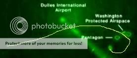
Gen. Clyde Vaughn: "There wasn't anything in the air, except for one airplane, and it looked like it was loitering over Georgetown, in a high, left-hand bank," he said. "That may have been the plane. I have never seen one on that (flight) pattern." Georgetown is a sector of the District of Columbia jammed with shops and restaurants - it is one of the city's most vital tourist draws. Commercial aircraft that are either approaching or departing from nearby Ronald Reagan National Airport do not fly over Georgetown, and rather trace their flight route over the nearby Potomac River,
i40.photobucket.com...
Joseph Candelario: As I was looking across the river towards the direction of the Pentagon, I noticed a large aircraft flying low towards the White House. This aircraft then made a sharp turn and flew towards the Pentagon
i40.photobucket.com...
Stuart Artman, walking near the Washington Monument: "I saw the plane that hit the Pentagon. It went behind some trees."
Scott Cook: Later, we were told that it was a 757 out of Dulles, which had come up the river in back of our building, turned sharply over the Capitol, ran past the White House and the Washington Monument, up the river to Rosslyn, then dropped to treetop level and ran down Washington Boulevard to the Pentagon.
From E-mail: I remember reading a quote from a congressman at the time saying he saw the 757 approach the Capitol from southeast, make a "fighter-pilot
turn" directly over the Capitol, and head west before curving around
again and hitting the west side of the Pentagon going east.
Ken Ford: flew up the river from National. ( Perhaps he is mixed up on South being "up river")
Then on 9/21/01, they tried changing what really happened
Sources say the hijacked jet continued east at a high speed toward the city, but flew several miles south of the restricted airspace around the White House.
[...]
"That is not the radar data that we have seen," Fleischer said, adding, "The plane was headed toward the White House."
www.cbsnews.com...
[SIZE=7]The Cover-up:[/SIZE]
Now that we have figured out exactly where the planes were at, they decided to bolster up their phony flight path:
First in Oct. 2001, with the Danielle O'Brien 20/20 interview, they illustrated the phony path:
...and the 911 Commission Hearings animated version, that of course shows the official flight path and the plane on the SOUTH SIDE:
Which of course led to the 2006 release of the NTSB Flight Path Study of "Flight 77":
The problem was, old versions of the original flight path were still floating around, here are two National Geographic versions:
And this one:
Our confusion was always in the flight path of the C-130 bringing it by the Mall and the plane being able to come in from his left hand side of his windscreen, yet this did not jive with the official NTSB flight path:
z9.invisionfree.com...=5665&st=0
Apparently, since we caught on to their crap they actually CHANGED the C-130's story and location, taking him away from THE MALL and placing him flying southwest to meet this phony flight path, and try and make their BS story work.
They apparently also try and support, many of the suspect witnesses' accounts of the C-130 veering away before even reaching the Pentagon.
THIS DID NOT HAPPEN.
Scott Cook described it perfectly.
Green: Scott Cook
Red: RADES Data
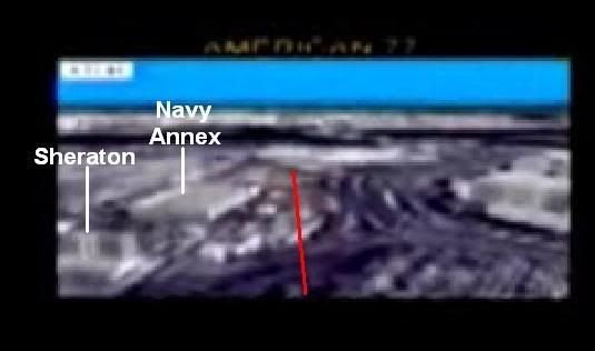
Directly in back of the plume, which would place it almost due west from our office, a four-engine propeller plane, which Ray later said resembled a C-130, started a steep decent towards the Pentagon. It was coming from an odd direction (planes don’t go east-west in the area), and it was descending at a much steeper angle than most aircraft. Trailing a thin, diffuse black trail from its engines, the plane reached the Pentagon at a low altitude and made a sharp left turn, passing just north of the plume, and headed straight for the White House.
All the while, I was sort of talking at it: "Who the hell are you? Where are you going? You’re not headed for downtown!" Ray and Verle watched it with me, and I was convinced it was another attack. But right over the tidal basin, at an altitude of less than 1000 feet, it made another sharp left turn to the north and climbed rapidly. Soon it was gone, leaving only the thin black trail.
This jives with the C-130 pilot's accounts and actions. He traveled WEST, then flipped a U and traveled EAST.
Like I mentioned earlier, Kieth Wheelhouse, Joel Sucherman, and a few others have this "second plane", the C-130. veering off in a bank out of there, in a U-Turn to the West. The problem is he obviously didn't do this, is this what the flyover plane would have done?
From AVweb:
C-130 followed 757 into the Pentagon?
"AVweb has also learned that this flight was being trailed by a military Lockheed C-130 Hercules transport during the final stages of its approach to the Pentagon. As the 757 struck the Pentagon and exploded, trained observers told AVweb that the C-130 executed what appeared to be "a high-G 180-degree turn" and departed the area."
What the hell?
2001-09-13 20:38:56+00
www.flutterby.com...
Perhaps this was the early stage for the covering up the flyover.
[edit on 29-10-2007 by Craig Ranke CIT]
reply to post by Craig Ranke CIT
I looked but did not see it (It may just be my bad eyes) but has the type of C-130 been identified? Was it a Compass Call, Combat Talon, etc or just a garden variety Herc? j/c
I looked but did not see it (It may just be my bad eyes) but has the type of C-130 been identified? Was it a Compass Call, Combat Talon, etc or just a garden variety Herc? j/c
reply to post by FredT
Minnesota air National Guard, Duluth. 133rd AW. It looks like they have the basic old C-130H nothing cool like a EC-130 or MC-130.
Minnesota air National Guard, Duluth. 133rd AW. It looks like they have the basic old C-130H nothing cool like a EC-130 or MC-130.
reply to post by Boone 870
Yes.
Didn't you read the post?
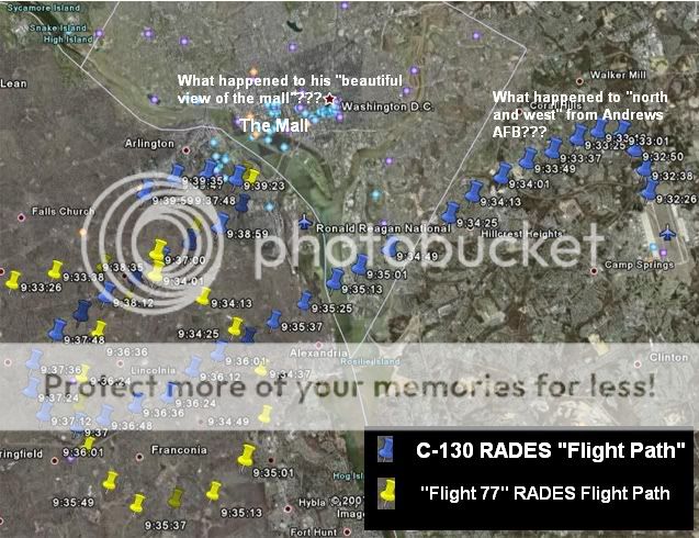
The RADES data completely contradicts what O'Brien has been explaining in detail all along.
This is the entire point.
The NTSB data and certainly the RADES data is fraudulent and does not reflect what the PentaPlane really did.
This fraudulent flight path released 5 and 6 years later has thrown people who were in a position to tell where the plane really flew and talked about it in the past 5 years completely under the bus.
People like Mineta & O'Brien.
We believe O'Brien is an innocent dupe.
That's why in every report your hear they leave the impression that he saw the plane hit the building when he specifically claims that he did not.
He never "followed" the plane.
By the time he turned around to follow it as requested it was too late and he was too far away to even know that the explosion came from the Pentagon.
The entire Pentagon case is going to come down to whether or not you believe the people who were there or the government data released years later that tells a completely different story.
[edit on 29-10-2007 by Craig Ranke CIT]
Yes.
Didn't you read the post?
The RADES data completely contradicts what O'Brien has been explaining in detail all along.
This is the entire point.
The NTSB data and certainly the RADES data is fraudulent and does not reflect what the PentaPlane really did.
This fraudulent flight path released 5 and 6 years later has thrown people who were in a position to tell where the plane really flew and talked about it in the past 5 years completely under the bus.
People like Mineta & O'Brien.
We believe O'Brien is an innocent dupe.
That's why in every report your hear they leave the impression that he saw the plane hit the building when he specifically claims that he did not.
He never "followed" the plane.
By the time he turned around to follow it as requested it was too late and he was too far away to even know that the explosion came from the Pentagon.
The entire Pentagon case is going to come down to whether or not you believe the people who were there or the government data released years later that tells a completely different story.
[edit on 29-10-2007 by Craig Ranke CIT]
reply to post by Boone 870
Oh sorry I didn't realize you were asking for a link.
I thought you were asking if we are considering the data.
We got it from John Farmer who is the one who allegedly got it via FOIA so no.
Oh sorry I didn't realize you were asking for a link.
I thought you were asking if we are considering the data.
We got it from John Farmer who is the one who allegedly got it via FOIA so no.
Craig and Co. Nice research overall and much credit goes to your efforts in exposing what really happened at the Pentagon.
Do you think it is possible that the C-130 viewed over D.C. that day may have launched a drone at the Pentagon prior to entering the airspace.
The following variants of the C-130 are used for drone control: GC-130A/DC-130A, DC-130E, & DC-130H
One the DC, after looking for the AA dives steep and at low altitude to act as part of the sleight of hand. Many confusing this plane with the AA plane. Second, the drone, launched away from the area is responsible for the Northern flight path that many testify to. The drone would account for eyewitnesses who think they saw a passenger jet or smaller plane, it would account for the image on the Pentagon released video, as well as the debris found within the Pentagon. The AA plane lands safely at Regan or not so safely in the Atlantic. Any thoughts would be appreciated.
reply to post by Swing Dangler
Hi SD,
We entertained this notion about a year and a half ago.
Check out this thread my partner made back then:
What If It Wasn't A C-130, You ever heard of a DC-130E?
But now that we have gone there and talked to so many eyewitnesses and progressed so far in our research we are certain that this is not what happened.
1. The plane that people saw was definitely a jet with turbine engines. Most describe it as white.
2. As described in this thread the C-130 pilot never had a chance to "follow" anything, did not witness anything impact the Pentagon, and was not seen by genuine witnesses in the area. We asked everyone this and even showed pictures. We believe that the few accounts of the C-130 "shadowing" the plane and veering off over the Pentagon were fabricated as a cover story for the fly over plane.
The information in this thread is key to unraveling the Pentagon deception.
I just posted a good summary for it here
I'll quote myself anyway for the record because it really helps to break it all down.
I just posted a good summary for it here
I'll quote myself anyway for the record because it really helps to break it all down.
The impression that the C-130 pilot, Steve O'Brien, claims he literally SAW the plane hit the Pentagon has been deliberately and erroneously promoted by the media and perpetrators.
The C-130 played an important role in this operation but we believe the pilot is nothing more than an innocent dupe.
The impression has been deliberately created that he "saw" the plane hit the Pentagon but not only has he NOT ever claimed such a thing......he specifically told us that after he turned around to follow the aircraft as per the request from Air Traffic Control.....it was too late and that he was so high up and far away from the building at the time that he did not even know the smoke was coming from the Pentagon at first!
Yet there are still a very few dubious published witness accounts talking about a "2nd plane" or "jet" that literally "shadowed" AA77 and veered away over the building immediately after the explosion.
Keith Wheelhouse is the only one to specifically call this ambiguous/mysterious alleged "2nd" plane a C-130.
Since virtually nobody we have interviewed saw a 2nd plane or jet at all and the pilot himself tells a completely different story we are quite certain that there is no truth to this account. Our recent interview with Wheelhouse reveals other fatal contradictions and a rather interesting demeanor from this anomalous witness.
It boils down to this.....confusion sown from the fact that a real yet mysterious C-130 and a real yet mysterious white E4B were seen in the airspace close to the time of the attack were blended with planted accounts of an ambiguous 2nd plane or jet that veered away from the building immediately after the explosion.
It's all simply meant as cover for the flyover.
With the recent release of the RADES data that is in complete contradiction with where the C-130 pilot says he flew and with 2 new extremely important interviews that we have obtained we feel we now have enough data to blow this wide open.
The perps have thrown O'Brien under the bus with the RADES data (as well as the NTSB data). They WANT you to think he was directly involved.
Don't fall for it.
Steve O'Brien:
These statements 100% prove the RADES data fraudulent.
North and west is not southwest.
The mall is north of Andrews.
The 84 RADES data shows him having traveled southwest and nowhere near the mall let alone just passing it headed westbound when he would have first seen the plane.
[edit on 6-12-2007 by Craig Ranke CIT]
"When we took off, we headed north and west and had a beautiful view of the Mall".
"We departed out of Andrews and climbed to 3,000 feet which took us by the south side of the mall".
"Our first sighting of the AA flight was just after we had gone by the mall westbound".
These statements 100% prove the RADES data fraudulent.
North and west is not southwest.
The mall is north of Andrews.
The 84 RADES data shows him having traveled southwest and nowhere near the mall let alone just passing it headed westbound when he would have first seen the plane.
[edit on 6-12-2007 by Craig Ranke CIT]
All of these independent sources PROVE the NTSB and/or RADES data fraudulent.
1. ABC news:
They are reporting a suspicious plane "circling" the White House before they even knew about the Pentagon attack which had just happened about 2 minutes prior to the report.
This is before the E4B even took off according to the RADES data.
The C-130 did not "circle the white house" and simply passed by south of the mall headed westbound.
The plane ABC is reporting is NOT shown in the RADES data and can only have been the decoy jet as it circled DC before crossing over the Potomac river to make it's loop in a descent to the Pentagon.
2. Colin Scoggins on the NORAD tapes at 9:35.
Although they suggest that Scoggins was supposed to be referring to AA77; 6 miles SE of the white house is irreconcilable with the NTSB flight path but is EXACTLY where the charter boat captain witness saw it approach from.
3. Charter boat captain witness on the Potomac.
We have a full on location interview with him on his boat on the river. His name will be released when the interview is released. He is CERTAIN that a passenger jet came from east of the Potomac and looped around north timed perfectly with the explosion at the Pentagon.
This is irreconcilable with both the NTSB and the RADES data.
4. Norman Mineta's description of what former deputy director of the FAA, Monte Belger, told him about the plane.
The NTSB flight path does not have the plane taking the "down river approach" at all.
This is completely irreconcilable with the NTSB and RADES data.
5. C-130 pilot Lt. Col. Steve O'Brien's account as outlined in the OP of this post.
Clearly his description of where he flew is irreconcilable with the RADES and NTSB data.
With all of these independent hard pieces of evidence it's impossible to consider the notion that the NTSB or RADES data is valid evidence.
1. ABC news:
They are reporting a suspicious plane "circling" the White House before they even knew about the Pentagon attack which had just happened about 2 minutes prior to the report.
This is before the E4B even took off according to the RADES data.
The C-130 did not "circle the white house" and simply passed by south of the mall headed westbound.
The plane ABC is reporting is NOT shown in the RADES data and can only have been the decoy jet as it circled DC before crossing over the Potomac river to make it's loop in a descent to the Pentagon.
2. Colin Scoggins on the NORAD tapes at 9:35.
Colin Scoggins: Just to report, be advised the aircraft is 4-6 miles SE (southeast) of the White House.
ATC: 6 miles SOUTHEAST of the White House?
Scoggins: Yup
ATC: He's moving away?
Although they suggest that Scoggins was supposed to be referring to AA77; 6 miles SE of the white house is irreconcilable with the NTSB flight path but is EXACTLY where the charter boat captain witness saw it approach from.
3. Charter boat captain witness on the Potomac.
We have a full on location interview with him on his boat on the river. His name will be released when the interview is released. He is CERTAIN that a passenger jet came from east of the Potomac and looped around north timed perfectly with the explosion at the Pentagon.
This is irreconcilable with both the NTSB and the RADES data.
4. Norman Mineta's description of what former deputy director of the FAA, Monte Belger, told him about the plane.
MINETA: So then someone came in, the same person came in and said, "Mr. Vice President, it -- the plane's 30-miles out." So I said, "Monte, can you see it, and where is it in relationship to the ground?"
He said, "Well, that's difficult to really determine. I would guess it's somewhere between Great Falls and National Airport, coming what they call the DRA, the down river approach."
The NTSB flight path does not have the plane taking the "down river approach" at all.
This is completely irreconcilable with the NTSB and RADES data.
5. C-130 pilot Lt. Col. Steve O'Brien's account as outlined in the OP of this post.
Clearly his description of where he flew is irreconcilable with the RADES and NTSB data.
With all of these independent hard pieces of evidence it's impossible to consider the notion that the NTSB or RADES data is valid evidence.
reply to post by Boone 870
Boone,
Our discussion belongs in this thread as it is off topic from the CNN white plane post.
But it's clear there is nothing more to discuss.
The "south side of the mall" is north and west or else north west of Andrews just like O'Brien says.
It is not southwest.
O'Brien's account fatally contradicts the radar data that has him traveling soutwest.
Wow! A whole load of data to sift through here. Thank you for the presentation.
On the subject of the Pentagon, I have an old favorite called PentagonStrike. I'm sure many people here have already seen it, but I thought I'd put it up there since it was the first thing that really got me started on questioning 9/11.
On the subject of the Pentagon, I have an old favorite called PentagonStrike. I'm sure many people here have already seen it, but I thought I'd put it up there since it was the first thing that really got me started on questioning 9/11.
reply to post by Craig Ranke CIT
Agreed. The thread you are referring to is here, www.abovetopsecret.com...
Sorry about the bad image links in the other thread. A moderator said that it is not uncommon and the problem usually occurs when the image is hosted by ATS. It seems like people using Firefox have more problems than others.
Please let me know if any of the images I post on this thread are not working.
Boone,
Our discussion belongs in this thread as it is off topic from the CNN white plane post.
Agreed. The thread you are referring to is here, www.abovetopsecret.com...
Sorry about the bad image links in the other thread. A moderator said that it is not uncommon and the problem usually occurs when the image is hosted by ATS. It seems like people using Firefox have more problems than others.
Please let me know if any of the images I post on this thread are not working.
reply to post by Boone 870
Perhaps you should just use photobucket. It works fine.
Just change the img tags to im.
But no matter what kind of graphic you make you can not change the fact that the south side of the mall is north and west from Andrews AFB just like O'Brien describes.
Not southwest.
This means that O'Brien's claims about where he flew fatally contradict the 84 RADES data.
There is no way around it.
Steve O'Brien:
These statements 100% prove the RADES data fraudulent.
North and west is not southwest.
Perhaps you should just use photobucket. It works fine.
Just change the img tags to im.
But no matter what kind of graphic you make you can not change the fact that the south side of the mall is north and west from Andrews AFB just like O'Brien describes.
Not southwest.
This means that O'Brien's claims about where he flew fatally contradict the 84 RADES data.
There is no way around it.
Steve O'Brien:
"When we took off, we headed north and west and had a beautiful view of the Mall".
"We departed out of Andrews and climbed to 3,000 feet which took us by the south side of the mall".
"Our first sighting of the AA flight was just after we had gone by the mall westbound".
These statements 100% prove the RADES data fraudulent.
North and west is not southwest.
reply to post by Craig Ranke CIT
Flight 77 was not traveling EASTBOUND when O'Brien first spotted it.
O'Brien says:
According to the Minnesota Star Tribune, O'Brien also said this;
That works out fine with the R.A.D.E.S. recorded radar data. Especially if X marks the spot where O'Brien first saw flight 77 in the image below.
originally posted by Craig Ranke
While O'Brien is traveling WESTBOUND, the plane's traveling EASTBOUND toward him, turning NORTHBOUND and back to EASTBOUND heading while in the 30-45 degree bank. The plane essentially crosses in front of him, flies around/below them heading towards the Potomac/mall/whitehouse or Potomac/Pentagon, then down river near Reagan National before finally turning out of it's bank and to it's final heading toward the Pentagon.
Flight 77 was not traveling EASTBOUND when O'Brien first spotted it.
O'Brien says:
"We were at about 3,500 feet at the time that I first noticed this commercial airliner in our 12 o'clock position in about a 45-degree bank, which is unusual for a large aircraft to be descending and turning at a 45-degree bank turn like that, so that really got our attention."
Our first sighting of the AA flight was just after we had gone by the mall westbound.
[...]
The 30-45 degree bank I described was always in reference to the AA flight during its initial pass across our flight path when it turned from a northerly heading to an eastbound heading.
According to the Minnesota Star Tribune, O'Brien also said this;
If O'Brien was traveling westbound, then Flight 77 would have almost been pointing northbound.
"When we took off, we headed north and west and had a beautiful view of the Mall," he said. "I noticed this airplane up and to the left of us, at 10 o'clock. He was descending to our altitude, four miles away or so. That's awful close, so I was surprised he wasn't calling out to us. Source
That works out fine with the R.A.D.E.S. recorded radar data. Especially if X marks the spot where O'Brien first saw flight 77 in the image below.
Originally posted by Boone 870
Flight 77 was not traveling EASTBOUND when O'Brien first spotted it.
True.
He had "just passed the mall" traveling westbound. Your X has him far from the mall traveling southwest.
If O'Brien was traveling westbound, then Flight 77 would have almost been pointing northbound.
It likely was at that point since the plane he saw was not on the NTSB flight path. We have proof of this from the NORAD tapes, the FAA, ABC news, O'Brien himself, and our independent charter boat captain witness as I outlined a couple of posts above. Until you can debunk all of these sources you can not use the NTSB flight path as a valid reference to where the plane flew.
That works out fine with the R.A.D.E.S. recorded radar data. Especially if X marks the spot where O'Brien first saw flight 77 in the image below.
It does not work out fine with O'Brien's statements.
That is not "just passed the mall" or anywhere near the mall.
Besides.....he says he traveled north and west after taking off.
Not southwest.
This makes everything else you claim moot since you are ignoring where O'Brien says he flew.
reply to post by Boone 870
Also....
You have not provided an explanation for why he wouldn't have seen the plane earlier than your X on such a clear beautiful day with "unlimited visibility" as you said.
Clearly according to the RADES data at 9:34:25 he would have a better view of the plane then he would the mall since he was flying right towards to the plane and not the mall.
[edit on 9-12-2007 by Craig Ranke CIT]
reply to post by Craig Ranke CIT
O'Brien did not state how far past the mall he was. Also, he did not state how far south of the mall he was.
You're using nonspecific information to make specific claims. All the statements O'Brien made were relative to his position during the flight.
You are interpreting his words to match your theory.
Just because you don't believe that a 4-5 mile vantage point from an aircraft can be considered a ''wonderful veiw'' doesn't mean that O'Brien should have been right above the mall to have that veiw.
North and west. Two separate words, two separate directions. You are the one that believes he flew northwest. He departed to the north and then flew west.
GREEN=Northwest flightpath
RED=Actual flightpath
BLUE=West
WHITE=Southwest
The two yellow thumbtacks represent positions from the radar data. As you can see by the redline, Gopher06 flew closer to west than it did to the southwest.
He had "just passed the mall" traveling westbound. Your X has him far from the mall traveling southwest.
O'Brien did not state how far past the mall he was. Also, he did not state how far south of the mall he was.
You're using nonspecific information to make specific claims. All the statements O'Brien made were relative to his position during the flight.
You are interpreting his words to match your theory.
Just because you don't believe that a 4-5 mile vantage point from an aircraft can be considered a ''wonderful veiw'' doesn't mean that O'Brien should have been right above the mall to have that veiw.
Besides.....he says he traveled north and west after taking off.
Not southwest.
North and west. Two separate words, two separate directions. You are the one that believes he flew northwest. He departed to the north and then flew west.
GREEN=Northwest flightpath
RED=Actual flightpath
BLUE=West
WHITE=Southwest
The two yellow thumbtacks represent positions from the radar data. As you can see by the redline, Gopher06 flew closer to west than it did to the southwest.
As to the visibility question, you're lucky to see a 747 at two-three miles when it's on final approach sometimes. Seeing a 757 at beyond
4-5 miles, with no aid to help you other than a rough area to look is all but impossible. A 757 is NOT a large aircraft. It's a narrow body which
makes it even harder if it's in a head on approach to you.
[edit on 12/9/2007 by Zaphod58]
[edit on 12/9/2007 by Zaphod58]
new topics
-
Psychotronic Operation Rwanda Who Wants To Be A Refugee?
ATS Skunk Works: 5 minutes ago -
AI phrenology
Science & Technology: 7 hours ago
top topics
-
4/27/24 New Jersey Earthquake
Fragile Earth: 12 hours ago, 8 flags -
CIA is alleged to be operat social media troll frms in Kyiv
ATS Skunk Works: 15 hours ago, 6 flags -
AI phrenology
Science & Technology: 7 hours ago, 3 flags -
Fun with extreme paints
Interesting Websites: 14 hours ago, 2 flags -
Rainbow : Stargazer
Music: 16 hours ago, 1 flags -
Psychotronic Operation Rwanda Who Wants To Be A Refugee?
ATS Skunk Works: 5 minutes ago, 0 flags
active topics
-
Psychotronic Operation Rwanda Who Wants To Be A Refugee?
ATS Skunk Works • 1 • : TimBurr -
So this is what Hamas considers 'freedom fighting' ...
War On Terrorism • 278 • : FlyersFan -
Killings of Palestinian children are soaring in the West Bank.
World War Three • 162 • : FlyersFan -
Ireland VS Globalists
Social Issues and Civil Unrest • 16 • : TimBurr -
University of Texas Instantly Shuts Down Anti Israel Protests
Education and Media • 383 • : FlyersFan -
Why Files Our Alien Overlords | How We Secretly Serve The Tall Whites
Aliens and UFOs • 16 • : TheValeyard -
4/27/24 New Jersey Earthquake
Fragile Earth • 6 • : soulrevival -
Some hard numbers about the Vax and the effort to cover up said numbers
General Conspiracies • 84 • : annonentity -
Australian PM says the quiet part out loud - "free speech is a threat to democratic dicourse"...?!
New World Order • 12 • : BeTheGoddess2 -
Supreme Court Oral Arguments 4.25.2024 - Are PRESIDENTS IMMUNE From Later Being Prosecuted.
Above Politics • 122 • : Zanti Misfit