It looks like you're using an Ad Blocker.
Please white-list or disable AboveTopSecret.com in your ad-blocking tool.
Thank you.
Some features of ATS will be disabled while you continue to use an ad-blocker.

Pentagon "NTSB animation" is wrong!
page: 2share:
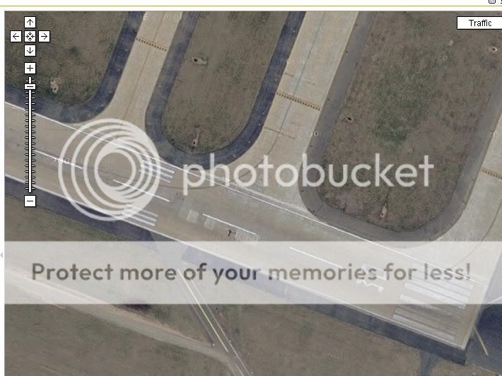
They put it North of Citgo, but the data released from the black box, appears to put it on the flight path SOUTH of Citgo, as stated in the official
reports. That would line it up perfectly with the light poles and impact hole in the side of the Pentagon. I say appears, because there's still a
little discussion going on about magnetic variation.
So what does that mean?
Im still trying to figure out if this is an attempt to debunk the pentacons statement that the plane was on the north side of the Citco.
Im still trying to figure out if this is an attempt to debunk the pentacons statement that the plane was on the north side of the Citco.
It's an attempt to find the truth. That's what it means. It's not an attempt to "debunk" anyone, but to simply find the truth.
It's not that hard. The Pilots for 911 Truth released an animation that APPEARS to show the plane going North of the CITGO station. Caustic Logic
and several other people have analyzed the data that was released, and they have found evidence that it does NOT show the plane was North of the
station. Now we're trying to find the truth based on the data released.
Thats what I missed. I thought the data showed the plane on the south side of the citgo and you were debating why pentacon showed it on the north.
Okay, Acme, as Zaphod says, I'm trying to find the truth. However, my attitude is that these videos are probably wrong, so I'm going on a
presumption (perhaps wrong) that seeking the truth and debunking are the same in this case. It's about the animation only right now, which plays a
major role in the Pilots' PBB video, and a brief supporting role only in the PentaCon. So I'm not trying to debunk the 'Con here, but looking at
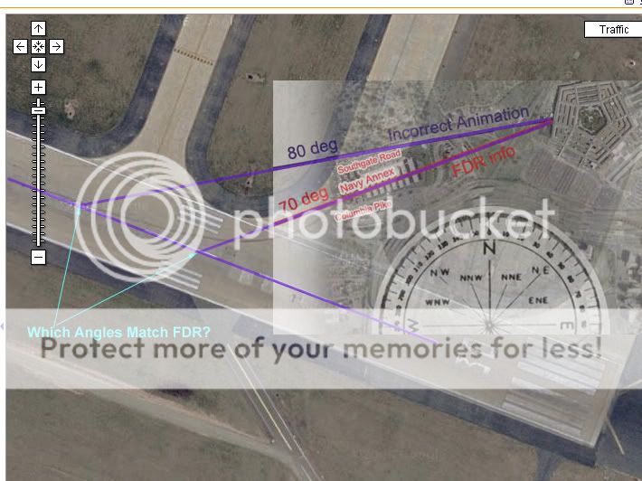
data that says the same thing - north of the Citgo - and it seems to be pretty wrong. Their 70 magnetc heading is on that path, while the NTSB/ASCE
mapping of the same mag heading lines up with the official story.
Right now I need to get clarification on magnetic north compared to geographic north on 9/11 and what that means for my over-certain intro post. I'll be looking for that info tonight. Debunking? Maybe, we'll see. Truth? That's prime, and I'm determined to find that whether it means my guesses were right or wrong. This could be a boost for the too-north path before all is said and done!
Right now I need to get clarification on magnetic north compared to geographic north on 9/11 and what that means for my over-certain intro post. I'll be looking for that info tonight. Debunking? Maybe, we'll see. Truth? That's prime, and I'm determined to find that whether it means my guesses were right or wrong. This could be a boost for the too-north path before all is said and done!
Isn't the 70 degree unadjusted compass going to be 80 degrees on the map. At that area the needle is deflected 10 degrees away from true north.
Is that why the 70 heading is plotted as the 80 degree course?
How does the aircraft industry account for this?
Give out headings with adjustments, do the aircraft instruments adjust, etc.
Surely pilots would know about this.
Is that why the 70 heading is plotted as the 80 degree course?
How does the aircraft industry account for this?
Give out headings with adjustments, do the aircraft instruments adjust, etc.
Surely pilots would know about this.
Caustic,
How about looking at the original data for the flight path at the point of take-off? Do we know which runway FL 77 left from?
If so, we can compare the direction at impact with the direction at take-off and match-up the directional reading from the FDR. The direction at impact relative to the direction at take-off should tell the whole story.
Just looked it up on Google... FL 77 left from runway 30 at Dulles, and was directed to a heading of 270.
[edit on 28-5-2007 by nick7261]
[edit on 28-5-2007 by nick7261]
[edit on 28-5-2007 by nick7261]
Making progress...
Just found the entire csv file. The original magnetic heading matches up with runway 30 at 301 degrees. The final magnetic heading is 70 degrees.
This means that the angle between the take-off runway and the impact at the Pentagon must be 70 + (360-301) = 70 + 59 = about 130 degrees.
If we use a compass and measure the lines on the above constructed image, the angle that's at 130 degrees will be the correct flight path.
Now I need to find a compass to put on the pic...
[edit on 28-5-2007 by nick7261]
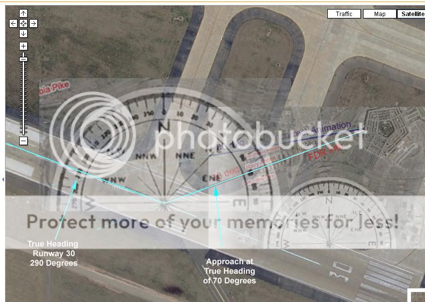
Runway 30 at Dulles has a 301 magnetic heading, and a 291 true heading. You subtract 10 degrees from the heading in Washington to get the true
heading. So if the plane impacted the Pentagon on a MAGNETIC heading of 070 it was on a TRUE heading of 060.
Originally posted by Zaphod58
Runway 30 at Dulles has a 301 magnetic heading, and a 291 true heading. You subtract 10 degrees from the heading in Washington to get the true heading. So if the plane impacted the Pentagon on a MAGNETIC heading of 070 it was on a TRUE heading of 060.
This is the csv file:
COUNTER,NAVtrackangletrue,NAVtrackanglemag,GMThr,GMTmin,GMTsec
151729,53.4,64,13,37,9
151730,54.5,64,13,37,13
151731,54.5,65.4,13,37,13
151732,55.9,65.4,13,37,13
151733,55.9,66.8,13,37,13
151734,57.3,66.8,13,37,17
151735,57.3,68.2,13,37,17
151736,58.4,68.2,13,37,17
151737,58.4,68.9,13,37,17
151738,58.7,68.9,13,37,21
151739,58.7,68.9,13,37,21
151740,59.1,68.9,13,37,21
151741,59.1,69.3,13,37,21
151742,59.1,69.3,13,37,25
151743,59.1,69.3,13,37,25
151744,59.4,69.3,13,37,25
151745,59.4,70,13,37,25
151746,60.5,70,13,37,29
151747,60.5,71,13,37,29
151748,61.2,71,13,37,29
151749,61.2,71.4,13,37,29
151750,61.5,71.4,13,37,33
151751,61.5,71.7,13,37,33
151752,61.5,71.7,13,37,33
151753,61.5,71.7,13,37,33
151754,61.5,71.7,13,37,37
151755,61.5,71.7,13,37,37
151756,61.5,71.7,13,37,37
151757,61.5,71.7,13,37,37
151758,61.5,71.7,13,37,41
151759,61.5,71.4,13,37,41
151760,61.2,71.4,13,37,41
151761,61.2,71.4,13,37,41
151762,61.2,71.4,13,37,45
151763,61.2,71.4,13,37,45
151764,61.2,71.4,13,37,45
www.aa77fdr.com...
61.2 True, 71.4 mag
Does this help?
Yes, because to be North of the Citgo he would have been on about a 080 heading. According to this he was on a 061 true 071 magnetic, which lines up
nicely with the gov't reports.
[edit on 5/28/2007 by Zaphod58]
[edit on 5/28/2007 by Zaphod58]
Originally posted by Zaphod58
Yes, because to be North of the Citgo he would have been on about a 080 heading. According to this he was on a 061 true 071 magnetic, which lines up nicely with the gov't reports.
[edit on 5/28/2007 by Zaphod58]
There's still a problem. Ignore Caustic's labels for the time being.
When you put the compass on the runway vs. the Pentagon approach, the angle should be 129 degrees (70 on the approach, plus 360-301 = 59 on take-off). However, when you put the compass on the superimposed graphic I made, you get an angle of 140 degrees between take-off and Pentagon approach, not 129 degrees.
To get the 129 degrees, you need to use Caustic's purple line, which corresponds to his corrected graphics for true vs. magnetic north.
In other words, Caustic's adjustment was correct, and the P491T data (and whole story) is incorrect, based on their own FDR data.
But doesn't this also mean the light pole path cannot be correct as well? The light pole path corresponds to a 70 degree true heading, not magnetic.
It's looking like somebody tried to work backwards from the light pole path and create the FDR data. In any event, the P491T analysis is completely off. The plane couldn't have passed north of the Citgo and had a 70 degree heading.
Originally posted by roadgravel
Isn't the 70 degree unadjusted compass going to be 80 degrees on the map. At that area the needle is deflected 10 degrees away from true north.
Is that why the 70 heading is plotted as the 80 degree course?
That’s what I’m not sure of yet. Zaphod seems to feel it’s the opposite, and he’s pretty smart. I'm just slow today. I usually shine late.
How does the aircraft industry account for this?
Give out headings with adjustments, do the aircraft instruments adjust, etc.
Surely pilots would know about this.
John Lear hasn’t stepped in yet, has he? Maybe he went fishing this weekend and will help explain tomorrow why the animation is right on?
Originally posted by roadgravel
Isn't the 70 degree unadjusted compass going to be 80 degrees on the map. At that area the needle is deflected 10 degrees away from true north.
Is that why the 70 heading is plotted as the 80 degree course?
You SUBTRACT 10 degrees from the magnetic heading to get the TRUE heading in Washington DC. If you look at the information for runway 30 at Dulles, which is where Flight 77 took off from, the magnetic heading is 301 degrees (runway numbers are magnetic headings). The TRUE heading of runway 30 is 291. So while your compass is going to be showing you a heading of 301 degrees, you're going to be POINTING at 291 degrees.
RUNWAY 30
Latitude: 38-56.016617N
Longitude: 077-27.353883W
Elevation: 287.8 ft.
Gradient: 0.2
Traffic pattern:left
Runway heading:301 magnetic, 291 true
Originally posted by Caustic Logic
That’s what I’m not sure of yet. Zaphod seems to feel it’s the opposite, and he’s pretty smart. I'm just slow today. I usually shine late.
Here are a couple of graphics that might help:
The first shows the take-off and approach headings using the TRUE headings. The second shows the same with the magnetic headings:
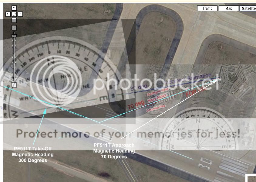
Caustic, the title of your thread seems to be accurate. The NTSB/PF911T flight recorder data is internally inconsistent.
If you look at the second graphic, you'll see that the runway from which FL 77 took off (runway 30 at Dulles) has a true heading of 290, and a magnetic heading of 300.
The approach into the Pentagon, according to the PF911T is 70 degrees magnetic. But if you look at the data file, the take-off is 300 magnetic. This means, as you already correctly figured out, the approach to the Pentagon must be coming in at a steeper angle. If FL 77 came in at this angle north of the Citgo, it would have hit the Pentagon far to the left of the crash site.
In order to hit the Pentagon at the crash location, FL 77 could NOT have passed north of the Citgo.
Another way to look at it like this... according to the PF911T data, there was a 130 angle between take-off and approach (70 deg approach, 360-300 = 60 at take-off). We know for sure the take-off heading from the image of runway 30 at Dulles. We then crank the angle 130 degrees clockwise from the runway to get the approach to the Pentagon, according to the PF911T data.
This brings FL 77 into the Pentagon along a path pretty close to your purple line. To me it looks like somebody tried faking the data and made a mistake.
Awesome job catching this!!!!
fair enough. The reason I questioned if you were debunking pentacon, is because the animation like you said plays a small part in the film.
I feel the testimony of the 2 cops who said the plane was on the north side were pretty strong evidence that the plane they saw did not knock down the light poles. This to me would solidify the theory of conspiracy into a fact of a deliberate cover up of what did knock over the light poles.
I was just checking to see that if this compass error turns out to be manufactured fake evidence to create a conspiracy, that you would not be dismissing the main part of pentacon which is the north side testimony.
I have seen your work before and it is very clear you are looking to expose the truth no matter what that truth is.
Some people on ATS feel so strongly one way or another they tend to look for only the evidence that supports their view.
Nick: About this CSV file site you found:
Very interesting. Do you know who put this up? It's very stripped down, with only these variables (Last frame):
COUNTER: 151764,
NAVtrackangletrue: 61.2,
NAVtrackanglemag: 71.4,
GMT: 13,37,45
By this, we had on 9/11 a mag/true north declination of -10.2 degrees. Could well, be, but oddly, that heading doesn’t match what I’ve been seeing elsewhere.
- The NTSB gave the ASCE a mag heading of 70, which fit the building damage. Rounded off?
- The heading graph in the NTSB's Specialist's study are unreadable to that degree - about 70, so...
- Last frame from my CSV downloaded from P49T (these values plus hundreds more):
Eastern, 09:37:44,
VERTICAL, 0.663,
LONGITUDINAL, 0.132,
LATERAL, 0.031,
PRESSURE, 173,
MAG, 70.0,
- Even the animation heading dial is sensitive enough to show one degree changes, it shows 70 as well, no more, no less.
And this one shows 71.4 degrees somehow. Hmmm…
We have a contradiction.
And confusion.
How odd! Guess we'll have to take the word from the experts. Or not...
I will be back with some more analysis later on. Thanks all for the good thoughts and input! This thread is rocking, no matter which way it goes.
Originally posted by nick7261
Caustic, the title of your thread seems to be accurate. The NTSB/PF911T flight recorder data is internally inconsistent.
If you look at the second graphic, you'll see that the runway from which FL 77 took off (runway 30 at Dulles) has a true heading of 290, and a magnetic heading of 300.
Well I'm glad to hear that, but haven't yet wrapped my brain around your reasoning to get there. I have to head out soon and won't be able to get back into this until a bit later. Thanks for putting all this work in, mate. It will be appreciated soon.
I think it'll take a wile to see what my CSV says for true vs. mag headings... it's a mess.
There's a tiny bit of error in any magnetic compass from what I remember. It's usually no more than a degree or two. It's also possible to have
errors in the compass. That could account for the difference between the 070 reading and the 071 from the black box. Or it could be that as you
suggested it was altered. It's definitely something to look into though.
new topics
-
BIDEN Admin Begins Planning For January 2025 Transition to a New President - Today is 4.26.2024.
2024 Elections: 1 hours ago -
Big Storms
Fragile Earth: 2 hours ago -
Where should Trump hold his next rally
2024 Elections: 5 hours ago -
Shocking Number of Voters are Open to Committing Election Fraud
US Political Madness: 6 hours ago -
Gov Kristi Noem Shot and Killed "Less Than Worthless Dog" and a 'Smelly Goat
2024 Elections: 7 hours ago -
Falkville Robot-Man
Aliens and UFOs: 7 hours ago -
James O’Keefe: I have evidence that exposes the CIA, and it’s on camera.
Whistle Blowers and Leaked Documents: 7 hours ago -
Australian PM says the quiet part out loud - "free speech is a threat to democratic dicourse"...?!
New World Order: 8 hours ago -
Ireland VS Globalists
Social Issues and Civil Unrest: 9 hours ago -
Biden "Happy To Debate Trump"
2024 Elections: 9 hours ago
top topics
-
James O’Keefe: I have evidence that exposes the CIA, and it’s on camera.
Whistle Blowers and Leaked Documents: 7 hours ago, 14 flags -
Australian PM says the quiet part out loud - "free speech is a threat to democratic dicourse"...?!
New World Order: 8 hours ago, 13 flags -
Blast from the past: ATS Review Podcast, 2006: With All Three Amigos
Member PODcasts: 12 hours ago, 13 flags -
Biden "Happy To Debate Trump"
2024 Elections: 9 hours ago, 12 flags -
Mike Pinder The Moody Blues R.I.P.
Music: 12 hours ago, 8 flags -
What is the white pill?
Philosophy and Metaphysics: 11 hours ago, 6 flags -
Shocking Number of Voters are Open to Committing Election Fraud
US Political Madness: 6 hours ago, 6 flags -
RAAF airbase in Roswell, New Mexico is on fire
Aliens and UFOs: 9 hours ago, 5 flags -
Ireland VS Globalists
Social Issues and Civil Unrest: 9 hours ago, 5 flags -
Where should Trump hold his next rally
2024 Elections: 5 hours ago, 5 flags
active topics
-
ALERT - U.S. President JOE BIDEN Examined and Found NOT OF SOUND MIND.
2024 Elections • 65 • : SchrodingersRat -
James O’Keefe: I have evidence that exposes the CIA, and it’s on camera.
Whistle Blowers and Leaked Documents • 13 • : theatreboy -
Where should Trump hold his next rally
2024 Elections • 21 • : Dandandat3 -
Gov Kristi Noem Shot and Killed "Less Than Worthless Dog" and a 'Smelly Goat
2024 Elections • 45 • : cherokeetroy -
RAAF airbase in Roswell, New Mexico is on fire
Aliens and UFOs • 9 • : Degradation33 -
President BIDEN's FBI Raided Donald Trump's Florida Home for OBAMA-NORTH KOREA Documents.
Political Conspiracies • 38 • : SchrodingersRat -
Big Storms
Fragile Earth • 11 • : GENERAL EYES -
BIDEN Admin Begins Planning For January 2025 Transition to a New President - Today is 4.26.2024.
2024 Elections • 7 • : WannabeeAuCourant -
Joe Biden and Donald Trump are both traitors
2024 Elections • 65 • : MrMez -
Mood Music Part VI
Music • 3112 • : underpass61