It looks like you're using an Ad Blocker.
Please white-list or disable AboveTopSecret.com in your ad-blocking tool.
Thank you.
Some features of ATS will be disabled while you continue to use an ad-blocker.

Pentagon "NTSB animation" is wrong!
page: 3share:
Originally posted by acmeartifacts
fair enough. The reason I questioned if you were debunking pentacon, is because the animation like you said plays a small part in the film.
I feel the testimony of the 2 cops who said the plane was on the north side were pretty strong evidence that the plane they saw did not knock down the light poles. This to me would solidify the theory of conspiracy into a fact of a deliberate cover up of what did knock over the light poles.
I was just checking to see that if this compass error turns out to be manufactured fake evidence to create a conspiracy, that you would not be dismissing the main part of pentacon which is the north side testimony.
I have seen your work before and it is very clear you are looking to expose the truth no matter what that truth is.
Some people on ATS feel so strongly one way or another they tend to look for only the evidence that supports their view.
Cool. You're alright. I can be too hard nosed sometimes. I do not fear infighting if I feel it's justified. And as for the PentaCon, let's just pretend they really did see this too-north path and it's true after all. We're only looking at the FDR and what it says, true or not, and how the animation lines up. It doesn't seem to line up with the FDR data, which was its whole claim to fame. So it's got nothing but being done wrong. The FDR shows the official path, whether true or a lie. Final numbers and analysis coming.
Sorry for all the foreshadowing.
Originally posted by Caustic Logic
Nick: About this CSV file site you found:
Very interesting. Do you know who put this up? It's very stripped down, with only these variables (Last frame):
I have no idea who put this up! I found it from the PF911T forum. Make sure you check out the home page:
www.aa77fdr.com...
Originally posted by Zaphod58
There's a tiny bit of error in any magnetic compass from what I remember. It's usually no more than a degree or two. It's also possible to have errors in the compass. That could account for the difference between the 070 reading and the 071 from the black box. Or it could be that as you suggested it was altered. It's definitely something to look into though.
Certainly is. Unless there are two compasses the box is reading, I don't think this both can be accurate. For my basic model it doesn't make a big difference, but now that we're starting to rely on its declination, we need to be sure it's an accurate data slate relative to the other sources. So yeah, I need to look into it.
Since I'm not a big believer in sleep that's what I'm looking into now. If I find anything overnight I'll put it up here and update
things.
The NTSB file that I downloaded puts it on a heading of 070 in the last recorded frame. They turned onto 070 at 9:37:36, and from then until impact
it went between about 069.6 to 070 several times, until the last frame of usable data at 9:37:44.
Good find Zaphod. We may be looking at the same thing. Is yours the CSV, an Excel spreadsheet? I've got it is txt format only - Excel won't touch it
on my machine. I can extract a few things from it, but for even the last frame to be totally readable would take about 10 hours of surgery. If
there's a way you can help me get a better readable version or snaps of it, I'd be much obliged.
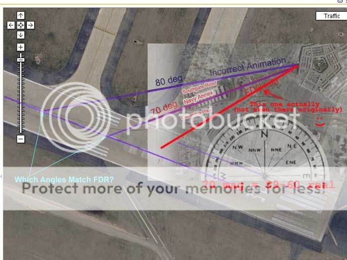
Well that link helps. Looks like either Snowygrouch or a coleague. But after looking more into the science of northiness, I've decided to ignore the small mag discrepancy for the moment and call it 70, and not to worry about the declination. For the purpose at hand a difference between 10.2 and 10.8 is not significant, and I guess DC area always has a declination from true north of -10-11 degrees.
So my earlier guess of a low enough range - like -6 deg - to explain the offness of the light poles is out and unsubstantiated. But as you pointed out earlier, a mapping of 70 real doesn't quite seem to account for the pole damage. I also thought hmmm.. it's a bit more north than I thought. As I mapped a corrected traj of 70 mag/60 real, it seemed a bit south from what I'd thought, and also seemed to almost line up with the pole damage area. I was kind of hoping to see the declination fix this by setting the line down the middle, but not to be so. It moves just a hair... To sort this out, I'll need to do check my more precise graphics of the official attack path to see how far off all this really is. My guess: it'll make more sense soon.
So opening Photoshop now to check out your stuff and update my own.
[edit on 29-5-2007 by Caustic Logic]
[edit on 29-5-2007 by Caustic Logic]
Originally posted by nick7261
I have no idea who put this up! I found it from the PF911T forum. Make sure you check out the home page:
www.aa77fdr.com...
Well that link helps. Looks like either Snowygrouch or a coleague. But after looking more into the science of northiness, I've decided to ignore the small mag discrepancy for the moment and call it 70, and not to worry about the declination. For the purpose at hand a difference between 10.2 and 10.8 is not significant, and I guess DC area always has a declination from true north of -10-11 degrees.
So my earlier guess of a low enough range - like -6 deg - to explain the offness of the light poles is out and unsubstantiated. But as you pointed out earlier, a mapping of 70 real doesn't quite seem to account for the pole damage. I also thought hmmm.. it's a bit more north than I thought. As I mapped a corrected traj of 70 mag/60 real, it seemed a bit south from what I'd thought, and also seemed to almost line up with the pole damage area. I was kind of hoping to see the declination fix this by setting the line down the middle, but not to be so. It moves just a hair... To sort this out, I'll need to do check my more precise graphics of the official attack path to see how far off all this really is. My guess: it'll make more sense soon.
So opening Photoshop now to check out your stuff and update my own.
[edit on 29-5-2007 by Caustic Logic]
[edit on 29-5-2007 by Caustic Logic]
Nick: In response to your earlier picture question:
Ihope that didn't throw off your argument, cause it sounds like we're on the same track. The runway idea was a good one, that's a definable point we can measure from and compare. And lo and behold, it confirms the declination we all seem now to agree on.
So maybe I can pretend I ignored magnetic north at first on purpose to be generous to the creators of the animation. In fact they're further from the reality of the Black Box record than I at first thought, by 20-22 degrees in fact, as if they were correcting backwards. And the adjusted flight path matches the physical evidence quite well.
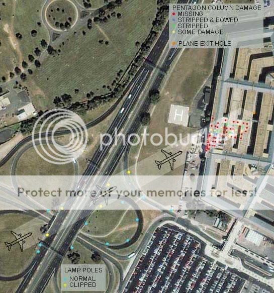
Here I used the famous graphic by who exactly I forget (Silent but Deadly?) and generally taken as accurate showing building damage, light poles, and the scaled 757 path that fits them both.
Setting the declination at -10.5 for simplicity, carefully scaling in the poles, the path impled by the above graphic, the adjusted FDR 70 reading, and the drawn trajectory seen in the animation as well my original wrong line I should not have said matched the evidence.
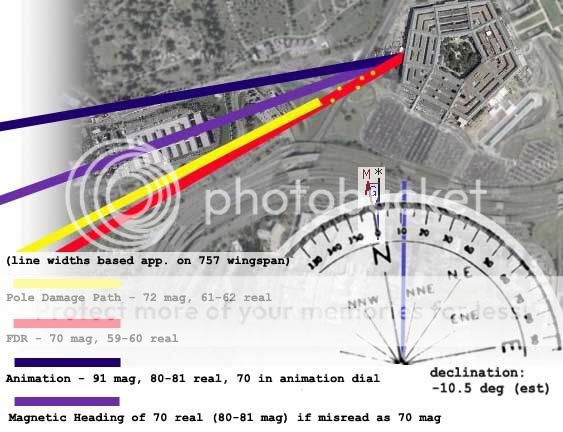
The line widths are about a 757 wingspan, and the red one, backed by the FDR data available, fits the evidence very well but if animated correctly, would vary greatly from what the Pilots show in their video.
I think we have nailed this one down here guys. Now give it a bit to sink in.
[edit on 29-5-2007 by Caustic Logic]
Ihope that didn't throw off your argument, cause it sounds like we're on the same track. The runway idea was a good one, that's a definable point we can measure from and compare. And lo and behold, it confirms the declination we all seem now to agree on.
So maybe I can pretend I ignored magnetic north at first on purpose to be generous to the creators of the animation. In fact they're further from the reality of the Black Box record than I at first thought, by 20-22 degrees in fact, as if they were correcting backwards. And the adjusted flight path matches the physical evidence quite well.
Here I used the famous graphic by who exactly I forget (Silent but Deadly?) and generally taken as accurate showing building damage, light poles, and the scaled 757 path that fits them both.
Setting the declination at -10.5 for simplicity, carefully scaling in the poles, the path impled by the above graphic, the adjusted FDR 70 reading, and the drawn trajectory seen in the animation as well my original wrong line I should not have said matched the evidence.
The line widths are about a 757 wingspan, and the red one, backed by the FDR data available, fits the evidence very well but if animated correctly, would vary greatly from what the Pilots show in their video.
I think we have nailed this one down here guys. Now give it a bit to sink in.
[edit on 29-5-2007 by Caustic Logic]
Originally posted by Caustic Logic
I think we have nailed this one down here guys. Now give it a bit to sink in.
[edit on 29-5-2007 by Caustic Logic]
Hey CL,
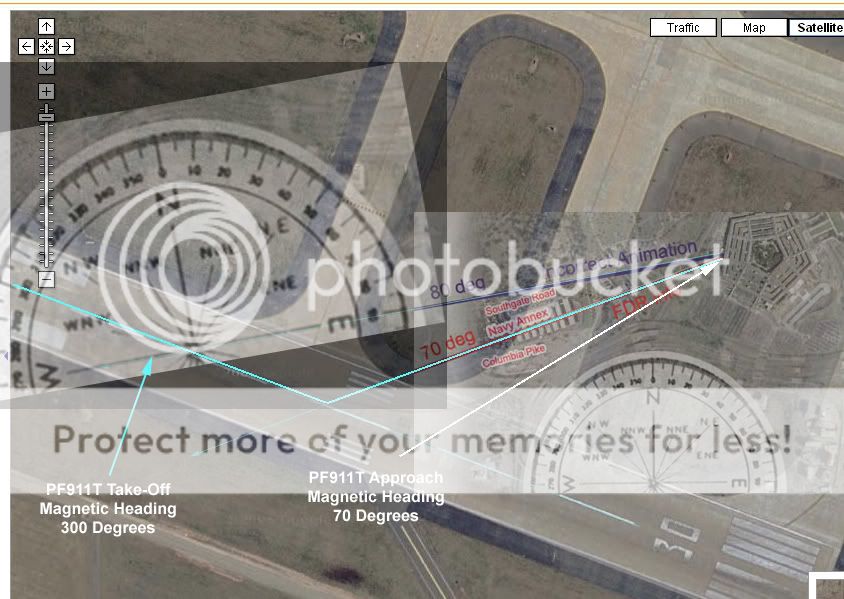
Nice job on this one! This is the image that helped it "sink in" most for me. The "NTSB" data shows that at take-off the heading was 300, and the approach to the Pentagon was 70. The white arrow in this image shows the angle FL77 would have HAD to take to match these headings.
Your last graphic shows this perfectly. BTW, when I measured to see how far off the flight path was, I got 21 degrees. The angle measured 150 instead of 129.
Now the bigger question is how can PF911T and the PentaCon be considered anything BUT a scam at this point? Surely these "pilots" who painstakingly figured out the altimeter reading, etc., should have noticed this glaring problem with the approach path.
The approach shown in their video is off by 20+ degrees! Plus, the headings in their video line FL77 up almost exactly with the "official" flight path. I find it hard to believe that the guys from PF911T could really be this incompetent not to notice that the heading readings match-up with the official flight path.
In fact, the ENTIRE point of their video was about how the NTSB video showed an approach path that varied from the official story, and just happened to match their eye-witness reports of FL77 north of the Citgo.
I'm calling bs.
Now there are only 2 questions:
1) Jack Tripper, if you're reading this, do you have any explanation for what appears to be a complete debunking of the PentaCon video?
2) Did you actually sell any of these PentaCon DVD's, and if so, do you plan on returning the money?
Originally posted by acmeartifacts
fair enough. The reason I questioned if you were debunking pentacon, is because the animation like you said plays a small part in the film.
The animation played a HUGE part in the original video, Pandora's Black Box. In fact, the entire point of the film was to point out that the NTSB flight data showed FL 77 coming in north of the Citgo, and not along the official flight path. Caustic has shown beyond all doubt that the PF911T's own heading data has FL77 coming in almost precisely along the official flight path, in line with the poles.
I feel the testimony of the 2 cops who said the plane was on the north side were pretty strong evidence that the plane they saw did not knock down the light poles. This to me would solidify the theory of conspiracy into a fact of a deliberate cover up of what did knock over the light poles.
I feel the PF911T failure to recognize the flight path from the data casts doubts on everything they've published, including the "witnesses" who claim to have seen a plane in a place that nobody else saw it.
I was just checking to see that if this compass error turns out to be manufactured fake evidence to create a conspiracy, that you would not be dismissing the main part of pentacon which is the north side testimony.
It's not a compass error. It seems to be a blatant oversight by the publishers of PF911T that's so egregious that it casts doubts about everything else related to their videos. It's not a matter of whether or not the data was faked to "create a conspiracy." The point is the self-proclaimed experts at PF911T should have figured out what Caustic did before they produced their videos. Instead, the PF911T appear to have used ATS to promote their video while misleading the members here.
To the PF911T, if I have misinterpreted the data and the conclusions, I apologize in advance. However, unless there is some explanation for the problems pointed out, you seem to have some explaining to do.
I hate to crash this party but a magnetic heading of 070 in the DC area gives a true heading of 080, not 060. The mag declination in DC is (-10
degrees).
A mag deviation of (-10) means you subtract 10 degrees from true to get magnetic and vice versa.
Magnetic headings indicate where the nose of the aircraft is pointing, not its course, which is indicated by a line drawn on a map through which the center of mass of the aircraft is travelling. Heading and course are almost never the same, however in this case the difference is negligable.
All is not lost however....P4911T accused some black gov agency of manipulating certain data to back up the official S of Citgo flight path. They even had a statiscal analysis geek analyze the data to show where it was tweaked. I suppose one could also accuse others of manipulating other parameters to match the N of Citgo theory??
If that's the case, then why does the runway at Dulles have a magnetic of 301 and a true of 10 degrees LESS? You have it the exact opposite. You
add 10 degrees to TRUE to get MAGNETIC. So a heading of 070 would be 060 true. The magnetic declination for Washington DC is 10 43' W which is -10
degrees.
[edit on 5/29/2007 by Zaphod58]
[edit on 5/29/2007 by Zaphod58]
www.ntsb.gov...
www.ntsb.gov...
The first is the PDF from the flight data recorder from Flight 77. There are several other interesting ones on there as well.
www.ntsb.gov...
The first is the PDF from the flight data recorder from Flight 77. There are several other interesting ones on there as well.
Originally posted by Zaphod58
If that's the case, then why does the runway at Dulles have a magnetic of 301 and a true of 10 degrees LESS? You have it the exact opposite. You add 10 degrees to TRUE to get MAGNETIC. So a heading of 070 would be 060 true. The magnetic declination for Washington DC is 10 43' W which is -10 degrees.
[edit on 5/29/2007 by Zaphod58]
You're correct. I blame my dyslexia. Everyone, ignore my embarrasing post and carry on.
Originally posted by darkbluesky
I hate to crash this party but a magnetic heading of 070 in the DC area gives a true heading of 080, not 060. The mag declination in DC is (-10 degrees).
A mag deviation of (-10) means you subtract 10 degrees from true to get magnetic and vice versa.
If what you're saying is true, then the FDR data from PF911T is off even MORE than what was first thought. The true heading of the runway is 290 degrees, but the mag heading shows 300 from the PF911T video. If what you're saying is correct, then the mag heading at take-off should have been 280, not 300.
Therefore, the heading at the Pentagon would also have been off by 20 degrees -the mag heading should have been 50 instead of 70.
Bottom line is there is no getting around the relative angles of take-off and the approach to the Pentagon. The relative angle is 130 degrees (70 on approach, 300 on take-off).
If the approach should have been a true heading of 80 like you said, that means the take-off must have been a true heading of 310. But we know the true heading of the runway is 290. A true heading of 310 on take-off would have put FL77 off the runway.
Just look at the above graphics.
It looks like somebody screwed up the FDR csv file with the purpose of trying to make the flight path match their theory.
Nick - I was completely wrong on the correction from mag to true heading in eastern US...see above.
Here is a link to the P4911T discussion regarding altered data:
z9.invisionfree.com...
Here is a link to the P4911T discussion regarding altered data:
z9.invisionfree.com...
Originally posted by darkbluesky
Nick - I was completely wrong on the correction from mag to true heading in eastern US...see above.
Here is a link to the P4911T discussion regarding altered data:
z9.invisionfree.com...
Thanks for the link!
So am I correct in my interpretation from the P4911T site? The claim is that the csv file was altered by the NTSB *after* the animation was made in an attempt to make the data fit the south flight path? And that the graphic at the end of the thread you referenced claims that the "altered" flight path would have FL77 missing the 1st pole?
If this is the claim, imo it's a real stretch of the imagination to say that the NTSB gave them the "real" animation video showing FL77 coming in north of the Citgo, and then realizing their mistake, edited the csv file to match the official flight path.
This is just my opinion, but to me this looks like yet another example of "CT Disease" -that's when you believe every tiniest bit of evidence that fits with your conspiracy, and characterize any evidence that contradicts your theory as part of the conspiracy. At some point it fails the laugh test.
This whole thing is just getting stupid at this point. So the government was able to fake everything that happened on that day, but was unable to
knock down the correct light poles, or put the correct “fake data” in the report. Is that what these guys are suggesting now?
Smells of damage control to me, regardless of what the Posted date on that sight says. What did they do, make that post first thing this morning, and backdate it so it looks like it was really the government messing with the data and not them?
Or am I missing the point of that thread?
I mean its not like the Truth Movement have not lied about stuff before now is it?
Originally posted by defcon5
What did they do, make that post first thing this morning, and backdate it so it looks like it was really the government messing with the data and not them?
No, the original thread talking about the manipulated FDR data was started on Feb. 27, 2007, which IMO makes PF911T even less credible.
Why?
Because they promoted the video and spammed the ATS boards in anticipation of the release of the video knowing full well that the FDR data MATCHED the official flight path, yet they continued to portray that the NTSB flight path data showed FL77 coming in north of the Citgo.
DC5, I'm leaning heavily your direction on this one. It wouldn't surprise me if the PF911T get accused of outright fraud.
Has anybody ever tried contacting the NTSB to see if they'll give out a copy of the animation to whoever asks for it? Or are the PF911T the only group that was fortunate enough to get the animation before the ahem... csv file was altered?
PS... just curious... how DO people qualify to get their own personal ATS discussion forums here?
Originally posted by nick7261
PS... just curious... how DO people qualify to get their own personal ATS discussion forums here?
I hear it involves bribing SO with large quantities of junk food and gourmet coffee…
Seriously though I think you just have to ask to be a conspiracy master, and show that you’re going to generate high quality threads worthy of your own forum.
[edit on 5/29/2007 by defcon5]
Originally posted by nick7261
Has anybody ever tried contacting the NTSB to see if they'll give out a copy of the animation to whoever asks for it? Or are the PF911T the only group that was fortunate enough to get the animation before the ahem... csv file was altered?
PS... just curious... how DO people qualify to get their own personal ATS discussion forums here?
Actually it's alcohol. Lots and lots of alcohol.
I posted a couple links to the NTSB that has the raw data from the FDR, and radar tracking, as well as what appears to be a flight path for Flight 77, and the others. I'm on a horrid computer for looking at PDFs and doing some things though so it's hard for me to go through them all properly.
new topics
-
WF Killer Patents & Secret Science Vol. 1 | Free Energy & Anti-Gravity Cover-Ups
General Conspiracies: 1 hours ago -
Hurt my hip; should I go see a Doctor
General Chit Chat: 2 hours ago -
Israel attacking Iran again.
Middle East Issues: 3 hours ago -
Michigan school district cancels lesson on gender identity and pronouns after backlash
Education and Media: 3 hours ago -
When an Angel gets his or her wings
Religion, Faith, And Theology: 4 hours ago -
Comparing the theology of Paul and Hebrews
Religion, Faith, And Theology: 5 hours ago -
Pentagon acknowledges secret UFO project, the Kona Blue program | Vargas Reports
Aliens and UFOs: 6 hours ago -
Boston Dynamics say Farewell to Atlas
Science & Technology: 6 hours ago -
I hate dreaming
Rant: 7 hours ago -
Man sets himself on fire outside Donald Trump trial
Mainstream News: 9 hours ago
top topics
-
The Democrats Take Control the House - Look what happened while you were sleeping
US Political Madness: 9 hours ago, 18 flags -
In an Historic First, In N Out Burger Permanently Closes a Location
Mainstream News: 11 hours ago, 16 flags -
A man of the people
Medical Issues & Conspiracies: 17 hours ago, 11 flags -
Man sets himself on fire outside Donald Trump trial
Mainstream News: 9 hours ago, 9 flags -
Biden says little kids flip him the bird all the time.
Politicians & People: 9 hours ago, 9 flags -
Michigan school district cancels lesson on gender identity and pronouns after backlash
Education and Media: 3 hours ago, 6 flags -
Pentagon acknowledges secret UFO project, the Kona Blue program | Vargas Reports
Aliens and UFOs: 6 hours ago, 6 flags -
Israel attacking Iran again.
Middle East Issues: 3 hours ago, 5 flags -
WF Killer Patents & Secret Science Vol. 1 | Free Energy & Anti-Gravity Cover-Ups
General Conspiracies: 1 hours ago, 5 flags -
Boston Dynamics say Farewell to Atlas
Science & Technology: 6 hours ago, 4 flags
active topics
-
Israel attacking Iran again.
Middle East Issues • 25 • : charlest2 -
Michigan school district cancels lesson on gender identity and pronouns after backlash
Education and Media • 8 • : TheMichiganSwampBuck -
I Guess Cloud Seeding Works
Fragile Earth • 29 • : Justoneman -
Man sets himself on fire outside Donald Trump trial
Mainstream News • 40 • : Vermilion -
When an Angel gets his or her wings
Religion, Faith, And Theology • 5 • : randomuser2034 -
Anyone one else having Youtube problems
Computer Help • 11 • : charlyv -
The Democrats Take Control the House - Look what happened while you were sleeping
US Political Madness • 68 • : Mahogani -
Candidate TRUMP Now Has Crazy Judge JUAN MERCHAN After Him - The Stormy Daniels Hush-Money Case.
Political Conspiracies • 404 • : Zanti Misfit -
In an Historic First, In N Out Burger Permanently Closes a Location
Mainstream News • 10 • : Degradation33 -
SC Jack Smith is Using Subterfuge Tricks with Donald Trumps Upcoming Documents Trial.
Dissecting Disinformation • 100 • : WeMustCare