It looks like you're using an Ad Blocker.
Please white-list or disable AboveTopSecret.com in your ad-blocking tool.
Thank you.
Some features of ATS will be disabled while you continue to use an ad-blocker.

Declassified spy images used to discover ancient sites.
page: 1share:
Some great archaeological discoveries being made thanks to declassified CORONA satellite images from the 60's and 70's. Good to see that some of the
cold war paranoia is being put to good use in discovering ancient sites from around the world. There was an excellent image of an ancient fortress
near the euphrates in syria at jebel khalid in my local paper which initially got me interested in looking further into this but i was able to find it
on the net.
It showed 10 sites of interest 1. farm buildings or animal quarters 2.cemetaries 3. roman military camp 4. large mound dating back to middle of bronze age 5. hellenistic building 6. cemetary 7. large pottery factory 8. pottery kiln 9. jebel khalid fortress 10. watch tower. All within fairly close proximity to each other and spanning back to 130000 yr old remains.
first source
second source
third source
corona images home page
some corona images
another source with image
Anyone have any more instances of declassified images being put to good use. Would be good to be able to use some of the military satellites now as im sure the imagery would be much better than these older ones. Probably have to wait another 30 or 40 yrs for them to be declassified though, by then alot of these sites will probably be ruined.
It showed 10 sites of interest 1. farm buildings or animal quarters 2.cemetaries 3. roman military camp 4. large mound dating back to middle of bronze age 5. hellenistic building 6. cemetary 7. large pottery factory 8. pottery kiln 9. jebel khalid fortress 10. watch tower. All within fairly close proximity to each other and spanning back to 130000 yr old remains.
first source
AUSTRALIAN researchers studying declassified spy satellite images have found widespread remains of ancient human settlements dating back 130,000 years in Syria.
The photographs were taken by United States military surveillance satellites operating under the CIA and defence-led Corona program in the late 1960s.
The team of researchers travelled to the Euphrates River Valley in April and June and searched sites they had painstakingly identified using the images, which were only declassified in the late 1990s.
They have already found tools from the Middle Palaeolithic period that are between 130,000 and 40,000 years old, and could have been made by either Neanderthals or early modern humans, as well as a few Acheulian tools that could date back several hundred thousand years.
second source
Oriental Institute archaeologists have used recently declassified satellite surveillance images to show that subtle land depressions–which had gone largely unnoticed by scholars–are actually the remnants of ancient roadways that knitted together the fabric of emerging civilizations in the ancient Near East.
These 5,000-year-old roadways were important thoroughfares for agricultural exchange and other commerce in an area of Syria and Iraq. It was here that expanding local settlements were coming into contact with cultures from southern Mesopotamia as urban civilization developed in the third millennium B.C., according to Tony Wilkinson, Research Associate at the institute, and Jason Ur, a researcher at the institute.
third source
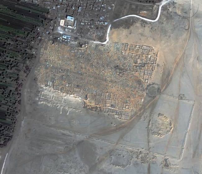
The Roman Legionary Fortress at El-Lejjun, Jordan (31.21N 35.8E), covers an area of approximately 4.6ha. Excavation has shown that the fortress was originally constructed around AD 300 but occupation extended through to the sixth century.
A recently declassified US satellite image acquired on 29 Sep 71 by a KH-4B photo-reconnaissance satellite shows the fortress in plan view. The image covers an area of some 1km by 1km with a pixel size equivalent to approximately 2.5m on the ground.
corona images home page
some corona images
another source with image
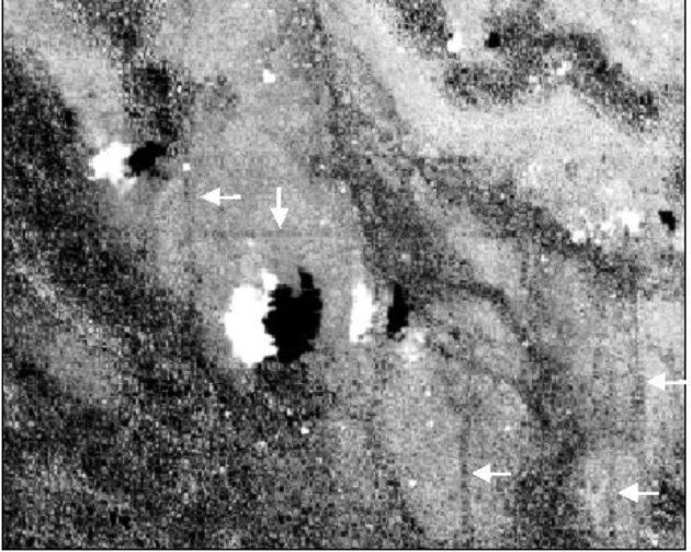
The Iron Age hillfort at Bury Hill near Andover, Hampshire, UK (51.18N 1.51W) comprises a circular tree-covered rampart enclosing an area of some 5.5 ha. A fortuitous gap in an otherwise mainly cloud-covered KH-4B satellite image acquired on 17 Aug 68 reveals the area surrounding the hillfort.
The course of the Andover by-pass, very soon after it had been constructed, is particularly apparent on the declassified image as a white linear feature in the upper right corner. In the centre of the image, the dark circular outline of the tree-covered ramparts of the hillfort can be readily identified. Within the enclosure, a dark area can be seen that appears to correspond to the location of a large tree.
Anyone have any more instances of declassified images being put to good use. Would be good to be able to use some of the military satellites now as im sure the imagery would be much better than these older ones. Probably have to wait another 30 or 40 yrs for them to be declassified though, by then alot of these sites will probably be ruined.
This si great news. Maybe now they will be able to solve a few mysteries, and re write history books. it goes to show that military and war technology
can be out to very good use, when one really wants to.
And its saying alot when its the NRO, one of the most super secretive agencies in the government, is willing to release these for research purposes.
And its saying alot when its the NRO, one of the most super secretive agencies in the government, is willing to release these for research purposes.
Yes good to see military technology being used for advancing knowledge of our history and not for killing innocents.
Not from the US, so who and what is the NRO exactly.
Not from the US, so who and what is the NRO exactly.
NRO: National Reconnaissance Office - www.nro.gov
see also:
NGIA: National Geospace-Intelligence Agency - www.ngia.mil
see also:
NGIA: National Geospace-Intelligence Agency - www.ngia.mil
Thanks for the links Tom. I particularly liked this part of their mission statement.
Freedoms sentinel
The NRO is guided by its vision of being Freedom's Sentinel in Space: One Team, Revolutionizing Global Reconnaissance.
Freedoms sentinel
Awesome post, intestingly enough, Richard Hoagland has compared silver and bury to structures on mars. Could there be a connection?
www.enterprisemission.com...
www.enterprisemission.com...
Im waiting for them to release something by mistake, human error, something we werent meant to see, not beyond the realms of possibility is it? just
need some eagle eyed individual out there in cyberspace to pick it up. not sure about the structures on mars or the moon for that matter, but since
reading some of John Lears comments im willing to keep an open mind.
This link is in my first post but i never saw the guy's name before.
Some ancient highways in Syria discovered using declassified satelite images. Heres the pdf article about there work
bold is my emphasis
Is it weird how this guy's name is Ur and he's studying ancient mesopotamia.
couple of other pics ive come across.
Here's the supposed image of Noahs Ark on Mt Ararat, looks like a rock formation to me but hey who knows. Apparently only released in march 2003. Not sure if its been posted here before.
Heres some more images from Afghanistan pre and post strike. Not archaeology based images but interesting anyway. The IMINT Gallery page has more images from ww2, vietnam, cuba, libya etc.
Some ancient highways in Syria discovered using declassified satelite images. Heres the pdf article about there work
bold is my emphasis
Oriental Institute archaeologists have used recently declassified satellite surveillance images to show that subtle land depressions–which had gone largely unnoticed by scholars–are actually the remnants of ancient roadways that knitted together the fabric of emerging civilizations in the ancient Near East
These 5,000-year-old roadways were important thoroughfares for agricultural exchange and other commerce in an area of Syria and Iraq. It was here that expanding local settlements were coming into contact with cultures from southern Mesopotamia as urban civilization developed in the third millennium B.C., according to Tony Wilkinson, Research Associate at the institute, and Jason Ur, a researcher at the institute
Is it weird how this guy's name is Ur and he's studying ancient mesopotamia.
Ur was an ancient city in southern Mesopotamia, located near the mouth (at the time) of the Euphrates and Tigris rivers on the Persian Gulf and close to Eridu. It is considered to be the earliest known civilization in world history. Because of marine regression, the remains are now well inland in present-day Iraq, south of the Euphrates on its right bank, and named Tell el-Mukayyar [1], near the city of Nasiriyah south of Baghdad.
couple of other pics ive come across.
Here's the supposed image of Noahs Ark on Mt Ararat, looks like a rock formation to me but hey who knows. Apparently only released in march 2003. Not sure if its been posted here before.
Heres some more images from Afghanistan pre and post strike. Not archaeology based images but interesting anyway. The IMINT Gallery page has more images from ww2, vietnam, cuba, libya etc.
Another couple of satellite images i hadnt come across before.
This isnt declassified images but interesting anyway. Visit link and click on thumbnail for full size picture.
link 1
This was picked up by IKONOS. Visit link and click on thumbnail for full size picture.
link 2
mojo
This isnt declassified images but interesting anyway. Visit link and click on thumbnail for full size picture.
link 1
The Great Aten Temple at Tell el-Amarna, Middle Egypt. Even though the northern enclosure wall of the temple is buried beneath a modern cemetery, using DigitalGlobe high resolution satellite imagery, it is still possible to see the buried wall. Credit: DigitalGlobe
"There are thousands of settlements that Egyptians don't even know are there," Parcak told LiveScience. "Nothing will ever destroy the Pyramids or the Temple of Luxor, but these huge settlement sites where we get a lot of information are being threatened. And that's how we find out how people lived."
This was picked up by IKONOS. Visit link and click on thumbnail for full size picture.
link 2
IKONOS satellite image revealing linear features that may have been Mayan irrigation canals. Credit: NASA/MSFC
Sever and co-worker Dan Irwin have been looking at satellite photos and, in them, Sever spotted signs of ancient drainage and irrigation canals in swamp-like areas near the Mayan ruins.
mojo
Originally posted by mojo4sale
Yes good to see military technology being used for advancing knowledge of our history and not for killing innocents.
Not from the US, so who and what is the NRO exactly.
Don't confuse the work of the military with that of civilian or academic institutions. I honestly don't believe the military was saying, "You know after we're done searching soft spots to attack and destroy they people here, lets make sure this data goes to good use for humanitarian purposes."
The military is single minded in the application of their money and technology. Period.
As for the data being recovered from their satellite sweeps, this is important to show that the reverse is true: military technology should be curtailed to allow more money to be allocated to peaceful applications of the technology.
Yes, yes, yes, Virginia, there will still be an Army, and a Navy, and an Airforce and Marines...just don't forget about the people they are defending and the reasons we are here on this planet. Is anyone posting on this thread willing to tell me that whatever archaeological bonuses we find in Iraq will be worth the invasion in the first place??
Conflict is not the best path to discovery. This was a happy accident, IMHO.
Originally posted by newtron25
Don't confuse the work of the military with that of civilian or academic institutions. I honestly don't believe the military was saying, "You know after we're done searching soft spots to attack and destroy they people here, lets make sure this data goes to good use for humanitarian purposes."
The military is single minded in the application of their money and technology. Period.
Whose confusing military and civilian institutions? The point of the thread is the ability of archealogists to use satellite images from declassified military satellites in the discovery of new finds. The images in the links from the OP are all cold war era vintage. That they are able to be used for a different purpose now, and not hidden away for eternity is a good thing, isnt it?
Originally posted by newtron25
Is anyone posting on this thread willing to tell me that whatever archaeological bonuses we find in Iraq will be worth the invasion in the first place??
It wont be worth it, i dont think anyone has said it would be, and as far as i know there havent been any satellite images from the present conflict released by the military for civilian use. Will probably have to wait 30-40 yrs for them to be declassified.
Originally posted by newtron25
This was a happy accident, IMHO.
By an accident do you mean that the archaelogists who discovered some of these finds were going through old satellite photo's for fun and just happened to stumble on these finds.
I actually think the results of the discovery's from these satellite images was more likely to involve a lot of hard work by dedicated professionals trying to use technology in a way that may better help us understand our history. Just my 2c.
Keep the change!
Scientists are opportunists. They don't normally work with the government unless they are the government scientists.
This was very likely a matter of conversations between someone who knew someone else in the Pentagon or somewhere.
It could have gone like this, "Hey, did you know they declassified extremely high res data over the parts of Egypt you are a specialist in?"
"No, you don't say. I was going to apply for grant money to take an expedition there, but now that you say this data is declassified, maybe I should mine it instead of collecting it the old fashioned way."
Or something like that.
And yes, the good thing is this information wasn't lost forever in a mountain of data that nobody cared about anymore. But the reason the information was collected in the first place was not to determine where ancient civilizations existed. It was for the purposes of warfare.
Are you going to tell me that the scientists really don't care where it comes from, as long as its good ol' important data?
Or would they rather have a dedicated system allocated for their own purposes of satellite scanning from the first place, the original intent being to find these places they were looking for?
That's the happy accident I was referring to. They are happy that the military, quite by accident, provided them with just what they needed to do their work.
That is all.
Originally posted by newtron25
Keep the change!
Scientists are opportunists. They don't normally work with the government unless they are the government scientists.
This was very likely a matter of conversations between someone who knew someone else in the Pentagon or somewhere.
It could have gone like this, "Hey, did you know they declassified extremely high res data over the parts of Egypt you are a specialist in?"
"No, you don't say. I was going to apply for grant money to take an expedition there, but now that you say this data is declassified, maybe I should mine it instead of collecting it the old fashioned way."
Or something like that.
I actually think its more likely that once the press release was reported and the executive order was signed that scientists in all sorts of different fields jumped at the chance to see if any of the images contained data that would pertain to their specialty, ie archeaology, agriculture, geology, meteorology etc, it would have been reported in most scientific journals i would have thought.
executive order
press release
press release 2
Originally posted by newtron25
And yes, the good thing is this information wasn't lost forever in a mountain of data that nobody cared about anymore. But the reason the information was collected in the first place was not to determine where ancient civilizations existed. It was for the purposes of warfare.
I think thats fairly well understood by the term "declassified satellite images"
Originally posted by newtron25
Or would they rather have a dedicated system allocated for their own purposes of satellite scanning from the first place, the original intent being to find these places they were looking for?
I'm fairly certain that they do have dedicated systems for public use but it probably is no where near as sophisticated as military technology nor would it be able to pass over certain areas unlike military technology. NASA has an archeaologist on their payroll as per one of my posts who has found what he thinks is mayan canals. So they can work hand in hand.
Thats my take on it anyway.
Originally posted by mojo4sale
I'm fairly certain that they do have dedicated systems for public use but it probably is no where near as sophisticated as military technology nor would it be able to pass over certain areas unlike military technology. NASA has an archeaologist on their payroll as per one of my posts who has found what he thinks is mayan canals. So they can work hand in hand.
Thats my take on it anyway.
You are kidding me. One archaeologist on staff to help "work hand in hand." And yet you presume that the thundering masses of other scientists have to wait for a press release?
This really doesn't sound fair, balanced or even effective. That's my take on it anyway.
There are many private and public satellite systems that scientists are able to use.
And i dont presume anything, you said that two guys having a conversation was the only way that this came to light, i showed that it more than likely came to light because it was released to the press, not some clandestine conversation that you implied.
What is your problem, this thread is about archeaological finds made due to declassified spy satellite images, not some paranoid nwo, military disinfo nutcase thread.
If you've got something to add to the thread i'll be more than willing to look it over but if your just fishing for a bite forget it because i wont waste my time.
cheers.
Originally posted by mojo4sale
There are many private and public satellite systems that scientists are able to use.
And i dont presume anything, you said that two guys having a conversation was the only way that this came to light, i showed that it more than likely came to light because it was released to the press, not some clandestine conversation that you implied.
What is your problem, this thread is about archeaological finds made due to declassified spy satellite images, not some paranoid nwo, military disinfo nutcase thread.
If you've got something to add to the thread i'll be more than willing to look it over but if your just fishing for a bite forget it because i wont waste my time.
cheers.
Okay, here is something to add:
What have the satellite data said about Visoko in Bosnia? Do you have any thoughts there?
Or is that too "NWO" for this thread? I didn't realize you could keep people confined to one thought around here...
Also, you misunderstand me. I am really excited by these finds. What I am not excited by is the fact that science needs to be fed the scraps all the time when monies could be allocated to research directly.
That way, it might be used toward even more spectacular finds.
Originally posted by newtron25
What have the satellite data said about Visoko in Bosnia? Do you have any thoughts there?
These are mostly cold war era images from CORONA, do you mean whether the Bosnia Pyramid shows up. I'm sure there are images of that area.
Originally posted by newtron25
Or is that too "NWO" for this thread? I didn't realize you could keep people confined to one thought around here...
Well the thread is in Ancient and Lost Civilisations forum. If i wanted to discuss the military ramifications i would have posted the thread in the appropriate forum, thats all. You can think and say just about anything as long as its within the T&C, but it helps if you stay on topic in the particular forum your posting in.
Originally posted by newtron25
Also, you misunderstand me. I am really excited by these finds. What I am not excited by is the fact that science needs to be fed the scraps all the time when monies could be allocated to research directly.
Sorry if i misunderstood, but the point of the thread is the discoveries being made using these images.
At least the scraps are being made available, they could well have stayed locked away, and who knows what damage may have been caused to these sites if they hadnt been released when they did.
And the access to satellite imagery for scientists now is much easier, in some ways thanks to the progress that the military made with this technology during the cold war. I am in no way an apologist for military or governments, i just liked the fact that some good was being made of these images captured by military satellites.
What have the satellite data said about Visoko in Bosnia? Do you have any thoughts there?
Semir Osmaganic says "All four sides are identical and match the points of the compass, facing north, south, east and west.
These findings have been borne out by satellite, thermal and radar analysis, geological, geodetic and topographic investigations. "
of course he would say that though
heres the topographical map for that area
heres the satellite image
can anyone see four identical sides that match the points of the compass
and here is what Osmaganic is making his statements from pointed out by a rampant bull
You funny, kid. Funny.
Not really all that tolerant, but your style, I like.
Not really all that tolerant, but your style, I like.
Some more interesting sites being discovered with the aid of satellite imagery, this time from IKONOS.
page1
page2
page3
page1
scientists are puzzled and amazed by an ancient pathway, long buried by volcanic ash and vegetation that has resurfaced again in satellite images from space.
page2
"The IKONOS satellite took away a huge amount of anxiety for us," Sheets says. It passes over the area once every six days, and when the weather is clear enough, "kaboom, we get gigabytes of imagery."
page3
In some areas there are side paths that lead straight off the main pathway, and then stop abruptly for no apparent reason.
new topics
-
A Warning to America: 25 Ways the US is Being Destroyed
New World Order: 58 minutes ago -
America's Greatest Ally
General Chit Chat: 1 hours ago -
President BIDEN's FBI Raided Donald Trump's Florida Home for OBAMA-NORTH KOREA Documents.
Political Conspiracies: 6 hours ago -
Maestro Benedetto
Literature: 8 hours ago -
Is AI Better Than the Hollywood Elite?
Movies: 8 hours ago -
Las Vegas UFO Spotting Teen Traumatized by Demon Creature in Backyard
Aliens and UFOs: 11 hours ago
top topics
-
President BIDEN's FBI Raided Donald Trump's Florida Home for OBAMA-NORTH KOREA Documents.
Political Conspiracies: 6 hours ago, 27 flags -
Supreme Court Oral Arguments 4.25.2024 - Are PRESIDENTS IMMUNE From Later Being Prosecuted.
Above Politics: 17 hours ago, 8 flags -
Weinstein's conviction overturned
Mainstream News: 16 hours ago, 8 flags -
Gaza Terrorists Attack US Humanitarian Pier During Construction
Middle East Issues: 13 hours ago, 8 flags -
Massachusetts Drag Queen Leads Young Kids in Free Palestine Chant
Social Issues and Civil Unrest: 15 hours ago, 7 flags -
Las Vegas UFO Spotting Teen Traumatized by Demon Creature in Backyard
Aliens and UFOs: 11 hours ago, 6 flags -
Meadows, Giuliani Among 11 Indicted in Arizona in Latest 2020 Election Subversion Case
Mainstream News: 14 hours ago, 5 flags -
2024 Pigeon Forge Rod Run - On the Strip (Video made for you)
Automotive Discussion: 12 hours ago, 4 flags -
Is AI Better Than the Hollywood Elite?
Movies: 8 hours ago, 3 flags -
Maestro Benedetto
Literature: 8 hours ago, 1 flags
active topics
-
Salvador Dali's Moustaches
People • 28 • : zosimov -
Is AI Better Than the Hollywood Elite?
Movies • 17 • : ThePsycheaux -
The best Rice dish i've ever tasted... Kimchi Rice
Food and Cooking • 26 • : lamhaocc -
A Warning to America: 25 Ways the US is Being Destroyed
New World Order • 1 • : 727Sky -
Massachusetts Drag Queen Leads Young Kids in Free Palestine Chant
Social Issues and Civil Unrest • 15 • : tarantulabite1 -
America's Greatest Ally
General Chit Chat • 1 • : BingoMcGoof -
How ageing is" immune deficiency"
Medical Issues & Conspiracies • 35 • : annonentity -
HORRIBLE !! Russian Soldier Drinking Own Urine To Survive In Battle
World War Three • 49 • : Freeborn -
Gaza Terrorists Attack US Humanitarian Pier During Construction
Middle East Issues • 30 • : Asher47 -
Electrical tricks for saving money
Education and Media • 8 • : anned1