It looks like you're using an Ad Blocker.
Please white-list or disable AboveTopSecret.com in your ad-blocking tool.
Thank you.
Some features of ATS will be disabled while you continue to use an ad-blocker.

blizzard for east coast this weekend
page: 4share:
Do you have an updated estimate?
I see alot are calling it further north and only rain for Philly and S. Jersey
I see alot are calling it further north and only rain for Philly and S. Jersey
Originally posted by l0rds0fcha0s
THIS IS A FIRST ESTIMATE..
will have a more accurate reading later.

Originally posted by l0rds0fcha0s
...boston and ny had 12-20 inches of snow....
[edit on 8-2-2006 by l0rds0fcha0s]
Actually, I live in Boston and it got way more then 20 inches of snow from the blizzard. Not really that important, but just wanted to point it out.
Let's say that this storm moves twenty to thirty miles south, it means over a foot of snow for the mountains of WV (me) and VA. Now, if the storm
system tracks thirty more miles to the north, it means more rain than snow for me. Let's add another low pressure system to the mix because one has
formed over the Texas Panhandle.
[edit on 2/9/2006 by gimmefootball400]
[edit on 2/9/2006 by gimmefootball400]
[edit on 2/9/2006 by gimmefootball400]
[edit on 2/9/2006 by gimmefootball400]
[edit on 2/9/2006 by gimmefootball400]
[edit on 2/9/2006 by gimmefootball400]
seems like more and more news mediums are saying a significant winter storm is gonna hit this weekend
l0rds, what's YOUR latest models and forcast saying?
thanks alot
(im getting more and more excited about the snow, i love this kind of weather, but come mid march i'll be all about spring fever)
-untermir
l0rds, what's YOUR latest models and forcast saying?
thanks alot
(im getting more and more excited about the snow, i love this kind of weather, but come mid march i'll be all about spring fever)
-untermir
I believe you guys in VT will get much less than I will here in central MA; I'd guess 4 to 6 for you guys, 10 to 12 for us...
[edit on 10-2-2006 by therainmaker]
[edit on 10-2-2006 by therainmaker]
Originally posted by Lanotom
Do you have an updated estimate?
I see alot are calling it further north and only rain for Philly and S. Jersey
Originally posted by l0rds0fcha0s
THIS IS A FIRST ESTIMATE..
will have a more accurate reading later.
will post updated here in a bit.. had to get some sleep
Originally posted by gimmefootball400
Let's say that this storm moves twenty to thirty miles south, it means over a foot of snow for the mountains of WV (me) and VA. Now, if the storm system tracks thirty more miles to the north, it means more rain than snow for me. Let's add another low pressure system to the mix because one has formed over the Texas Panhandle.
[edit on 2/9/2006 by gimmefootball400]
[edit on 2/9/2006 by gimmefootball400]
[edit on 2/9/2006 by gimmefootball400]
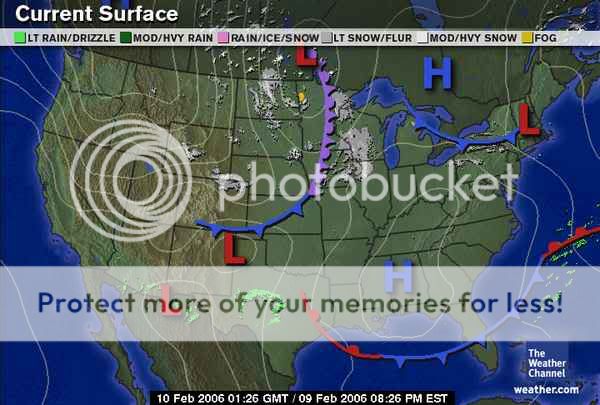
that wasa mistake on their drawing there isnt another low down there. if there we we
d be in for a monster all over the ne even us in ohio... i'm updatin my image now

Do you have a link to the pic , the third one above my post, where the map is all white with the snow colored in levels? TIA
...BOSTON AND THE NEW HAMPSHIRE BORDER. SOMEWHAT LOWER TOTALS OF 4 TO 8 INCHES CAN BE EXPECTED ON NANTUCKET AND THE OUTER PORTION OF CAPE COD...WHERE RAIN MAY MIX IN FOR A TIME SUNDAY MORNING. THIS IS A POTENTIALLY DANGEROUS WINTER STORM. TRAVEL MAY BE SERIOUSLY IMPACTED BY THE COMBINATION OF POOR VISIBILITY AND SLIPPERY ROADS. PLAN TO HAVE TRAVEL COMPLETED BY LATE SATURDAY AFTERNOON.
Lower predictions for outer Cape Cod where i am. Still, one never knows!
Originally posted by dgtempe
...BOSTON AND THE NEW HAMPSHIRE BORDER. SOMEWHAT LOWER TOTALS OF 4 TO 8 INCHES CAN BE EXPECTED ON NANTUCKET AND THE OUTER PORTION OF CAPE COD...WHERE RAIN MAY MIX IN FOR A TIME SUNDAY MORNING. THIS IS A POTENTIALLY DANGEROUS WINTER STORM. TRAVEL MAY BE SERIOUSLY IMPACTED BY THE COMBINATION OF POOR VISIBILITY AND SLIPPERY ROADS. PLAN TO HAVE TRAVEL COMPLETED BY LATE SATURDAY AFTERNOON.
Lower predictions for outer Cape Cod where i am. Still, one never knows!
it's going to be hard to tell... if the low pressure stays off the coast a little ways you will get alot... if the low stays inland you may mix with rain
Get ready East Coast megalopolis!
Washington DC-Baltimore area:
Philadelphia Area:
NY area:
Boston Area:
As time goes by these watches will be upgraded to warnings and snowfall amounts will be adjusted for different areas. Stay tuned....
Washington DC-Baltimore area:
...WINTER STORM WATCH REMAINS IN EFFECT FROM SATURDAY MORNING THROUGH LATE SATURDAY NIGHT...
......
A SWATH OF SNOWFALL OF 5 INCHES OR MORE IS LIKELY ACROSS THE AREA...WITH ACCUMULATIONS UP TO TEN INCHES POSSIBLE.
NORTHEAST WINDS AT 15 TO 25 MPH SATURDAY WILL SHIFT TO THE NORTH SATURDAY NIGHT. THE COMBINATION OF MODERATE TO HEAVY SNOW AND WIND HAS THE POTENTIAL TO REDUCE VISIBILITY TO BELOW ONE HALF OF A MILE. PLEASE BE PREPARED FOR THE POSSIBILITY OF HAZARDOUS WINTER WEATHER SATURDAY AND SATURDAY NIGHT. A WINTER STORM WARNING MAY NEED TO BE ISSUED LATER TODAY OR TONIGHT.
Philadelphia Area:
...WINTER STORM WATCH REMAINS IN EFFECT FROM SATURDAY AFTERNOON THROUGH SUNDAY MORNING...
.....
SNOWFALL AMOUNTS OVER MUCH OF OUR FORECAST AREA ARE EXPECTED TO REACH 6 TO 12 INCHES.
......
WITH THIS TYPE OF AN EXPLOSIVE EAST COAST STORM... IT IS ALSO POSSIBLE TO GET CONVECTION... OR THUNDER-SNOW... AT THE HEIGHT OF THE STORM. IF THIS OCCURS... SNOWFALL RATES COULD REACH 2 TO 3 INCHES AN HOUR. THIS WOULD CAUSE TOTAL ACCUMULATIONS TO EXCEED 12 INCHES.
NY area:
...BLIZZARD WATCH IN EFFECT FROM SATURDAY AFTERNOON THROUGH SUNDAY MORNING...
......
SNOW WILL BEGIN DURING SATURDAY AFTERNOON...AND BECOME HEAVY AT TIMES SATURDAY NIGHT. NORTHEAST WINDS WILL ALSO INCREASE SATURDAY NIGHT TO 25 TO 35 MPH WITH GUSTS UP TO 50 MPH...CAUSING BLIZZARD CONDITIONS ALONG WITH CONSIDERABLE BLOWING AND DRIFTING OF SNOW.
BY THE TIME THE SNOW ENDS SUNDAY MORNING...ACCUMULATIONS SHOULD AVERAGE 8 TO 12 INCHES...WITH LOCALLY HIGHER AMOUNTS POSSIBLE. THE HIGHEST TOTALS ARE MOST LIKELY TO OCCUR IN AND NEAR NEW YORK CITY...AND ACROSS WESTERN LONG ISLAND.
Boston Area:
...WINTER STORM WATCH IN EFFECT FROM SATURDAY AFTERNOON THROUGH SUNDAY AFTERNOON...
.....
THE HEAVIEST SNOW SHOULD FALL SATURDAY NIGHT INTO SUNDAY MORNING. IT IS VERY POSSIBLE THAT SNOWFALL RATES WILL REACH 3 INCHES PER HOUR AT TIMES. GUSTY NORTHEAST WINDS MAY CREATE AREAS OF BLOWING AND DRIFTING SNOW WITH POOR VISIBILITY.
NEAR BLIZZARD CONDITIONS ARE POSSIBLE IN THE HARTFORD...WORCESTER... BOSTON AND PROVIDENCE AREAS DURING THE HEIGHT OF THIS STORM.
BY THE TIME THE SNOW TAPERS OFF SUNDAY AFTERNOON...TOTAL SNOWFALL SHOULD AVERAGE 8 TO 14 INCHES.
As time goes by these watches will be upgraded to warnings and snowfall amounts will be adjusted for different areas. Stay tuned....
How about the Knoxville TN area?? We are in the Valley and we tend to miss most severe weather. It kinda spins around us due to the mountains on all
sides
Look like we will get any significant snow?? They are predicting it won't get down cold enough. That it will hover just above freezing
This morning the sunrise was spectacular. Magentas, violets, oranges and reds. The old saying of "Red in the morning sailor take warning...."
We will probably just get lots of freezing cold rain and mud. sigh.
I just remembered i have no food in the house. I hate it
when that happens.
Off topic, but do you know what the Supermarkets are like when a storm is predicted?
Right now its sunny and very cold in the Hyannis area.
when that happens.
Off topic, but do you know what the Supermarkets are like when a storm is predicted?
Right now its sunny and very cold in the Hyannis area.
Originally posted by llpoolej
How about the Knoxville TN area?? We are in the Valley and we tend to miss most severe weather.
Here's some more snowfall estimates:
Knoxville: 2"-5"
Asheville: 1"-3"
Boone: 1"-3"
Chattanooga: 1"-3"
Hickory: 1"-3"
Lexington: 2"-5"
Nashville: 1"-3"
More TN weather data here:
iwin.nws.noaa.gov...
wwwa.accuweather.com...
[edit on 10-2-2006 by Regenmacher]
looking the the low will be further inland than the meteorologists expected...
they still dont think so, but i see things with my own eyes.... here are some select city totals.
KNOXVILLE, TN 3 - 6"
ROANOKE, VA 4 - 8"
LEXINGTON, KY 4 - 8"
CHARLESTON, WV 5 - 9 "
COLUMBUS, OH 3 - 6"
BALTIMORE, MD 4 - 8 "
PHILADELPHIA, PA 8+
DOVER, DE 3 - 6"
STATE COLLEGE, PA 6 - 10"
PITTSBURGH, PA 6 - 10"
WASHINGTON D.C. 3 - 6"
NEWARK, NJ 4 - 8"
CAPE COD 4 - 8"
BOSTON, MA 8"+
NYC, NY 8"+
WILL LIST MORE IN A BIT.
[edit on 10-2-2006 by l0rds0fcha0s]
Originally posted by dgtempe
I just remembered i have no food in the house. I hate it
when that happens.
Off topic, but do you know what the Supermarkets are like when a storm is predicted?
Right now its sunny and very cold in the Hyannis area.
I went grocery shopping yesterday. Got stuff for cornbread, chili, steaks, chicken and all that jazz. In this area, all the bread and milk will be sold out by this evening. Driving is a PITA as we don't have adequate snow removal and we have lots of hills(it is all hills really)
So, yeah, I know what craziness goes on when snow is predicted. I sure wouldn't want to shop today!!!
Thanks lOrdsOfchaOs , You have been right , even before the weather men of national news stations have finally got your point. As this
was perfect as we will get more than some , and your understanding of weather related predictions are on the money you should and I ask for you to
become ATS,s weatherman. Very good reseach and very compendent understanding of weather patterns. I want to ask you though , maybe it is or maybe its
not relavent but concerning that the shift of the magnetic poles futher north , will this be a factor in changing weather patterns in the future. Many
Blessings
Originally posted by zman
Thanks lOrdsOfchaOs , You have been right , even before the weather men of national news stations have finally got your point. As this was perfect as we will get more than some , and your understanding of weather related predictions are on the money you should and I ask for you to become ATS,s weatherman. Very good reseach and very compendent understanding of weather patterns. I want to ask you though , maybe it is or maybe its not relavent but concerning that the shift of the magnetic poles futher north , will this be a factor in changing weather patterns in the future. Many Blessings
honestly i've researched and i think that an ice age is coming soon. within 20 years.. Reverse global warming.it's going to start getting warmer, which was already apparent, as we here in ohio had the warmest january in history here, as well with many other states....
is it the shift of the magnetic pole. not neccesarily, but that could have some factors on it. I think another thing that affected it was the tsunami from last winter... thanks wish i could be ats' weather man... haha.... i'm 2 for 2 and looking to keep going baby...
new topics
-
A Warning to America: 25 Ways the US is Being Destroyed
New World Order: 3 hours ago -
President BIDEN's FBI Raided Donald Trump's Florida Home for OBAMA-NORTH KOREA Documents.
Political Conspiracies: 9 hours ago -
Maestro Benedetto
Literature: 10 hours ago -
Is AI Better Than the Hollywood Elite?
Movies: 11 hours ago
top topics
-
President BIDEN's FBI Raided Donald Trump's Florida Home for OBAMA-NORTH KOREA Documents.
Political Conspiracies: 9 hours ago, 28 flags -
Gaza Terrorists Attack US Humanitarian Pier During Construction
Middle East Issues: 15 hours ago, 8 flags -
Massachusetts Drag Queen Leads Young Kids in Free Palestine Chant
Social Issues and Civil Unrest: 17 hours ago, 7 flags -
Las Vegas UFO Spotting Teen Traumatized by Demon Creature in Backyard
Aliens and UFOs: 14 hours ago, 6 flags -
A Warning to America: 25 Ways the US is Being Destroyed
New World Order: 3 hours ago, 6 flags -
Meadows, Giuliani Among 11 Indicted in Arizona in Latest 2020 Election Subversion Case
Mainstream News: 17 hours ago, 5 flags -
2024 Pigeon Forge Rod Run - On the Strip (Video made for you)
Automotive Discussion: 15 hours ago, 4 flags -
Is AI Better Than the Hollywood Elite?
Movies: 11 hours ago, 3 flags -
The functionality of boldening and italics is clunky and no post char limit warning?
ATS Freshman's Forum: 16 hours ago, 1 flags -
Maestro Benedetto
Literature: 10 hours ago, 1 flags
active topics
-
Definitive 9.11 Pentagon EVIDENCE.
9/11 Conspiracies • 426 • : Lazy88 -
A Warning to America: 25 Ways the US is Being Destroyed
New World Order • 3 • : AllisVibration -
Alternate Electors vs Fake Electors - What is the Difference.
2024 Elections • 117 • : ADVISOR -
-@TH3WH17ERABB17- -Q- ---TIME TO SHOW THE WORLD--- -Part- --44--
Dissecting Disinformation • 691 • : Imbackbaby -
Gaza Terrorists Attack US Humanitarian Pier During Construction
Middle East Issues • 34 • : AllisVibration -
Victoria government has cancelled the commmonwealth games, no money.
Regional Politics • 3 • : nazaretalazareta -
President BIDEN's FBI Raided Donald Trump's Florida Home for OBAMA-NORTH KOREA Documents.
Political Conspiracies • 19 • : ADVISOR -
When an Angel gets his or her wings
Religion, Faith, And Theology • 22 • : AcrobaticDreams1 -
King Charles 111 Diagnosed with Cancer
Mainstream News • 321 • : FlyersFan -
Is there a hole at the North Pole?
ATS Skunk Works • 41 • : burritocat