It looks like you're using an Ad Blocker.
Please white-list or disable AboveTopSecret.com in your ad-blocking tool.
Thank you.
Some features of ATS will be disabled while you continue to use an ad-blocker.

Discovery: Genesis, the World’s Largest Impact Crater
page: 1share:
This is a follow-up to my earlier two posts regarding the discovery of a 2,000-year-old
map and identification of the one place on Earth matching the scale and layout of
Plato's Atlantis.
These were samplings from a book in progress which is now complete: Maps, Myths & Paradigms.
Those articles covered subject matter from the first half of the book and provided an analysis of ancient maps of the Antarctic continent and Plato’s detailed description of Atlantis in conjunction with modern maps. This post pertains to significant findings contained in the second half comprising the analysis of modern maps and the challenges they present for our current geological paradigm.
I. Kamchatka: New Origins
II. Genesis
The progression seemed natural. While I had discovered a location that matched the scale and layout of Plato’s Atlantis, the observation by no means validated the site as the true location of Atlantis nor confirmed that the fabled civilization actually ever existed. Still, Plato’s description of two continents beyond the Mediterranean—Atlantis and a second large continent opposite a path of islands—is a remarkably accurate description of the Americas and the Caribbean islands that link the two continents. It left enough of an impression that I decided to pursue the Atlantis tale to the next level. I set out to identify the scope and the source of the cataclysm that potentially befell Atlantis. Plato’s account appeared to describe a global event with earthquakes occurring inside and outside the Mediterranean, potentially as far away as South America.
I. Kamchatka: New Origins
So began my research into a global cataclysm. Early on in the process, I discovered that a series of peninsular formations along the Asian coast did not all originate as geologists currently maintain. These peninsulas included Kamchatka, Korea and Japan—an island that was once a peninsula prior to becoming fully detached in the north. It would appear that plate tectonics, or more specifically continental drift, started off on the right path recognizing that continental plates do fracture and separate. Most are aware of this very basic concept and the oft-referenced example of the Americas’ original fit with Africa across the Atlantic.
Inexplicably, other very clear instances of fractured continental mass and separation were overlooked in favor of more complex and inconsistent processes of plate movement and plate generation that supported key aspects of plate tectonics. I believe Kamchatka, Japan, and Korea are all products of fracturing and separation much like the Americas and Africa. While geologists agree that Japan fractured free from the Asian coast, many believe Korea is the product of colliding and stacking continental fragments. Meanwhile, Kamchatka is believed to have originated as a series of volcanic islands that erupted up from the seafloor due to friction generated as the Pacific seafloor plate subducted beneath the Okhotsk Plate. Geologists claim that over time these islands grew together and eventually attached to the Asian mainland forming the Kamchatka Peninsula.
Had there been a continued focus on fracture mechanics, geologists would have recognized that Kamchatka was the product of fracturing and separation. In support of this new theory, the image below clearly shows that the Kamchatka Peninsula fits perfectly into a conforming pocket along the adjacent Asian coast. Not only does the coastal pocket exhibit a conforming point at the end and hump across its top, there are two isolated coastal points on each landmass that line up perfectly when the two are brought back together. These two coastal points were once joined together as an isthmus.
The Kamchatka separation represents two types of fractures: brittle and ductile. A brittle fracture is the type of fracture witnessed when an object like a ceramic vase is broken. The fragments exhibit little to no deformation so the fragments can oftentimes be reassembled and glued together nearly restoring the broken object to its original form. Brittle fracturing is exhibited along much of the span between Kamchatka and the Asian coast.
Ductile fracturing can be demonstrated by pulling apart a pliable, soft material like heated plastic. Pulling it apart leads to thinning and deformation of the mass until it finally thins too far and separates in the center. The two coastal points demonstrate this type of fracturing. Whereas most of Kamchatka broke free of the Asian continent via brittle fracturing, a small lone pliable region resisted immediate fracturing. After extending and thinning to its limit, the ductile isthmus fractured apart at its center and Kamchatka pivoted out in a counterclockwise direction from the Asian coast and onward to its current location.
I believe this discovery will be difficult to refute. The alternative is to retain the current plate tectonics view and believe that the peninsula randomly coalesced into a shape matching the Asian coast and for good measure generated a lone squared-off coastal point matching one inside the accommodating coastal pocket. It is like someone selling you cloth as hand-woven fabric while a torn flag with the same pattern flaps about immediately in the background. Sure, there is always the chance that coincidence is at play, but more than likely not.
These were samplings from a book in progress which is now complete: Maps, Myths & Paradigms.

Those articles covered subject matter from the first half of the book and provided an analysis of ancient maps of the Antarctic continent and Plato’s detailed description of Atlantis in conjunction with modern maps. This post pertains to significant findings contained in the second half comprising the analysis of modern maps and the challenges they present for our current geological paradigm.
I. Kamchatka: New Origins
II. Genesis
The progression seemed natural. While I had discovered a location that matched the scale and layout of Plato’s Atlantis, the observation by no means validated the site as the true location of Atlantis nor confirmed that the fabled civilization actually ever existed. Still, Plato’s description of two continents beyond the Mediterranean—Atlantis and a second large continent opposite a path of islands—is a remarkably accurate description of the Americas and the Caribbean islands that link the two continents. It left enough of an impression that I decided to pursue the Atlantis tale to the next level. I set out to identify the scope and the source of the cataclysm that potentially befell Atlantis. Plato’s account appeared to describe a global event with earthquakes occurring inside and outside the Mediterranean, potentially as far away as South America.
I. Kamchatka: New Origins
So began my research into a global cataclysm. Early on in the process, I discovered that a series of peninsular formations along the Asian coast did not all originate as geologists currently maintain. These peninsulas included Kamchatka, Korea and Japan—an island that was once a peninsula prior to becoming fully detached in the north. It would appear that plate tectonics, or more specifically continental drift, started off on the right path recognizing that continental plates do fracture and separate. Most are aware of this very basic concept and the oft-referenced example of the Americas’ original fit with Africa across the Atlantic.
The conforming coasts of the Americas and the African continent across the Atlantic drove the belief that these landmasses had fractured and separated apart. This belief would be the basis for the eventual formulation of the plate tectonics theory.
Inexplicably, other very clear instances of fractured continental mass and separation were overlooked in favor of more complex and inconsistent processes of plate movement and plate generation that supported key aspects of plate tectonics. I believe Kamchatka, Japan, and Korea are all products of fracturing and separation much like the Americas and Africa. While geologists agree that Japan fractured free from the Asian coast, many believe Korea is the product of colliding and stacking continental fragments. Meanwhile, Kamchatka is believed to have originated as a series of volcanic islands that erupted up from the seafloor due to friction generated as the Pacific seafloor plate subducted beneath the Okhotsk Plate. Geologists claim that over time these islands grew together and eventually attached to the Asian mainland forming the Kamchatka Peninsula.
Current theory: Geologists currently maintain that the Kamchatka Peninsula rose up from the seafloor as multiple volcanic islands that eventually merged together into one large island. Over time this large island expanded further to the north until it merged with the Asian mainland forming the peninsula that exists today.

Had there been a continued focus on fracture mechanics, geologists would have recognized that Kamchatka was the product of fracturing and separation. In support of this new theory, the image below clearly shows that the Kamchatka Peninsula fits perfectly into a conforming pocket along the adjacent Asian coast. Not only does the coastal pocket exhibit a conforming point at the end and hump across its top, there are two isolated coastal points on each landmass that line up perfectly when the two are brought back together. These two coastal points were once joined together as an isthmus.
New theory: A merged image of Kamchatka nestled back into an adjacent conforming pocket along the Asian coast. Two lone coastal points come back into perfect alignment (top center) further confirming the ancient fit.

The Kamchatka separation represents two types of fractures: brittle and ductile. A brittle fracture is the type of fracture witnessed when an object like a ceramic vase is broken. The fragments exhibit little to no deformation so the fragments can oftentimes be reassembled and glued together nearly restoring the broken object to its original form. Brittle fracturing is exhibited along much of the span between Kamchatka and the Asian coast.
Ductile fracturing can be demonstrated by pulling apart a pliable, soft material like heated plastic. Pulling it apart leads to thinning and deformation of the mass until it finally thins too far and separates in the center. The two coastal points demonstrate this type of fracturing. Whereas most of Kamchatka broke free of the Asian continent via brittle fracturing, a small lone pliable region resisted immediate fracturing. After extending and thinning to its limit, the ductile isthmus fractured apart at its center and Kamchatka pivoted out in a counterclockwise direction from the Asian coast and onward to its current location.
I believe this discovery will be difficult to refute. The alternative is to retain the current plate tectonics view and believe that the peninsula randomly coalesced into a shape matching the Asian coast and for good measure generated a lone squared-off coastal point matching one inside the accommodating coastal pocket. It is like someone selling you cloth as hand-woven fabric while a torn flag with the same pattern flaps about immediately in the background. Sure, there is always the chance that coincidence is at play, but more than likely not.
edit on 12-17-2018 by Doug Fisher because: (no reason given)
II. Genesis
Soon after determining that fracturing formed the linear array of coastal peninsulas, it became clear that Kamchatka, Korea and Japan were downward facing splinters, a pattern of coastal fracturing that suggested an impact from above. This initiated a search to the north of Kamchatka for signs of an impact. It was there that I discovered a unique pattern resting at the bottom of the Arctic seafloor.
The pattern exists as a sediment deposit forming a layered, terraced pattern with a very noticeable trend of arcing; the terracing pattern arcs back toward the Lomonosov Ridge at each end. This slightly distorted semicircular formation also gradually rises up nearly a mile from its lower inside layers to those forming the outside of the arc. Meanwhile, there exists a compact island set, Franz Josef Land, which—when the Gakkel expansion zone is closed back together—is centered within the arced terracing. Why is this significant? Prior to the opening of the Gakkel expansion zone, Franz Josef Land and the unique arced terracing formed the inner components of a complex crater. Complex craters comprise a central uplift similar to Franz Josef Land, which is formed at the crater’s center, surrounded by arced terracing which rises upward and outward to the crater’s outer rim. Terracing forms as a portion of the rim collapses downward to the base of a crater. Franz Josef Land and the surrounding terracing are remnants of the Genesis impact crater.
The Gakkel Ridge in the center of the expansion zone, and by extension the mid-Atlantic ridge, are products of a radial fracture generated by the Genesis impact. Meanwhile, the crater’s rim, the surrounding coasts of North America and Eurasia, vacated the immediate region shortly after impact. The only fragments of the rim to remain in place lie to either side equidistant from Franz Josef Land. From the span between these fragments and the width of the terracing, we can discern that the size of the Genesis crater was roughly 715 miles across. This is several times larger than the Vredefort Crater—currently the planet’s largest confirmed impact crater—which prior to erosion sat at 100 to 190 miles in diameter.
So what sort of effect would an impact of this magnitude have on our planet? I believe the impact completely transformed the northern hemisphere and transitioned the entire planet from one with a single unified crust to a planet with continent-sized fragments separated by vast oceanic basins.
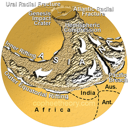
The above image reveals the immediate effects of this impact: the Genesis Hemispheric Impact Structure (GHIS). Extending down from the impact are two compression zones, one along the coast of Asia and the other along the coast of North America. The increased compression on the Asian continent, as witnessed in the buildup of the Himalayas, reveals greater displacement of continental mass. This is significant because the downward-facing peninsular splinters along the Asian coast indicated that the Asian continent had indeed shifted past the North American continent during the impact. The resulting shear fracture would eventually open up becoming the Pacific Ocean.
The entire pattern of compression extends down and then veers completely around the Genesis impact crater. There are two exceptions: the Sierra Madre, which were originally aligned with the Appalachian Mountains prior to the opening up of the Gulf of Mexico, and the Appalachian Mountains, which were in turn aligned with the Atlas Mountains in North Africa before the opening up of the Atlantic. This forms a compression pattern that, at the time of impact, was one continuous structure extending directly down from and entirely around the Genesis impact crater. It and all the landmass to the north also comprises just under half of Earth’s continental mass. The Genesis impact generated a path of compressed mass that encircled the entire northern hemisphere of a planet 54% Earth’s current size, therefore supporting the possibility that we live on an expanding Earth.
This compression ring represents a substantial amount of crustal displacement and similar to the shearing that occurred between Asia and North America, shearing also occurred above the compression zone. The planet’s largest and deepest inland bodies of water form a highly discernible ring paralleling the compression zone. These deep basins are a series of crustal shear fractures formed as the mountains compressed and displaced a substantial amount of continental crust alongside the stationary crust lying to the north of it.
Based on this new impact theory, mountain ranges believed to have formed hundreds of millions of years apart were actually formed within minutes of each other. Geologists currently maintain that larger majestic mountain ranges like the Himalayas and the Rockies were formed more recently while mountain ranges like the Appalachians are much older. They assume that lower ranges were once similar in height to the Himalayas and the Rockies but have been subjected to hundreds of millions of years of erosion.
Continued…
Soon after determining that fracturing formed the linear array of coastal peninsulas, it became clear that Kamchatka, Korea and Japan were downward facing splinters, a pattern of coastal fracturing that suggested an impact from above. This initiated a search to the north of Kamchatka for signs of an impact. It was there that I discovered a unique pattern resting at the bottom of the Arctic seafloor.
The pattern exists as a sediment deposit forming a layered, terraced pattern with a very noticeable trend of arcing; the terracing pattern arcs back toward the Lomonosov Ridge at each end. This slightly distorted semicircular formation also gradually rises up nearly a mile from its lower inside layers to those forming the outside of the arc. Meanwhile, there exists a compact island set, Franz Josef Land, which—when the Gakkel expansion zone is closed back together—is centered within the arced terracing. Why is this significant? Prior to the opening of the Gakkel expansion zone, Franz Josef Land and the unique arced terracing formed the inner components of a complex crater. Complex craters comprise a central uplift similar to Franz Josef Land, which is formed at the crater’s center, surrounded by arced terracing which rises upward and outward to the crater’s outer rim. Terracing forms as a portion of the rim collapses downward to the base of a crater. Franz Josef Land and the surrounding terracing are remnants of the Genesis impact crater.
Animation closing the Gakkel expansion zone and bringing Genesis’ central peak back to the center of the crater’s outer terracing. An overlay of the Theophilus lunar impact crater demonstrates this relationship of a central peak and the pattern of terracing which encircles it.

The Gakkel Ridge in the center of the expansion zone, and by extension the mid-Atlantic ridge, are products of a radial fracture generated by the Genesis impact. Meanwhile, the crater’s rim, the surrounding coasts of North America and Eurasia, vacated the immediate region shortly after impact. The only fragments of the rim to remain in place lie to either side equidistant from Franz Josef Land. From the span between these fragments and the width of the terracing, we can discern that the size of the Genesis crater was roughly 715 miles across. This is several times larger than the Vredefort Crater—currently the planet’s largest confirmed impact crater—which prior to erosion sat at 100 to 190 miles in diameter.
So what sort of effect would an impact of this magnitude have on our planet? I believe the impact completely transformed the northern hemisphere and transitioned the entire planet from one with a single unified crust to a planet with continent-sized fragments separated by vast oceanic basins.
The Genesis Hemispheric Impact Structure (GHIS): A circular concentric pattern of continental plate compression comprising the largest and tallest mountain ranges extending down from and around Genesis and the resulting internal shear fractures comprising the largest and deepest inland bodies of water that run parallel to the compression zone.

The above image reveals the immediate effects of this impact: the Genesis Hemispheric Impact Structure (GHIS). Extending down from the impact are two compression zones, one along the coast of Asia and the other along the coast of North America. The increased compression on the Asian continent, as witnessed in the buildup of the Himalayas, reveals greater displacement of continental mass. This is significant because the downward-facing peninsular splinters along the Asian coast indicated that the Asian continent had indeed shifted past the North American continent during the impact. The resulting shear fracture would eventually open up becoming the Pacific Ocean.
The entire pattern of compression extends down and then veers completely around the Genesis impact crater. There are two exceptions: the Sierra Madre, which were originally aligned with the Appalachian Mountains prior to the opening up of the Gulf of Mexico, and the Appalachian Mountains, which were in turn aligned with the Atlas Mountains in North Africa before the opening up of the Atlantic. This forms a compression pattern that, at the time of impact, was one continuous structure extending directly down from and entirely around the Genesis impact crater. It and all the landmass to the north also comprises just under half of Earth’s continental mass. The Genesis impact generated a path of compressed mass that encircled the entire northern hemisphere of a planet 54% Earth’s current size, therefore supporting the possibility that we live on an expanding Earth.
This compression ring represents a substantial amount of crustal displacement and similar to the shearing that occurred between Asia and North America, shearing also occurred above the compression zone. The planet’s largest and deepest inland bodies of water form a highly discernible ring paralleling the compression zone. These deep basins are a series of crustal shear fractures formed as the mountains compressed and displaced a substantial amount of continental crust alongside the stationary crust lying to the north of it.
List of inland bodies of water that form the inner ring of the GHIS sorted by size. Rank represents size rankings among world’s lakes.

Based on this new impact theory, mountain ranges believed to have formed hundreds of millions of years apart were actually formed within minutes of each other. Geologists currently maintain that larger majestic mountain ranges like the Himalayas and the Rockies were formed more recently while mountain ranges like the Appalachians are much older. They assume that lower ranges were once similar in height to the Himalayas and the Rockies but have been subjected to hundreds of millions of years of erosion.
Currently, the age of most mountain ranges roughly correlates with their height. Shorter ranges are believed to be far older, having experienced hundreds of millions of years of erosion. Accepting the existence of the Genesis impact, we find that ranges like the Atlas and Appalachian Mountains are lower because they were formed on the back end of the impact, while the Himalayas and Rockies grew out of the direct linear force of the impact. More importantly, all these mountain ranges were formed within minutes of each other and not over the span of hundreds of millions of years.

Continued…
…continued
This new theory maintains that a large celestial object, roughly 80 miles in diameter, impacted the planet in the north. The angled trajectory of the impactor transferred energy across Earth's crust generating a path of linear compression down the side of the planet. Larger mountains like the Himalayas and Rockies incurred the direct force of the impact generating the most compression. This compression extended downward to the equator of the smaller Earth then veered out all along the equator. Mountains like the Appalachians and Atlas Mountains are lower in stature because they lie opposite the main thrust therefore incurring far less compression.
Just to reiterate, when the Atlantic is closed up and the Americas are reconnected with Africa and Europe, it reveals a well-defined pattern of dual concentric rings comprising the largest and tallest mountain ranges in the northern hemisphere and a matching ring of the planet's largest and deepest inland bodies of water. Both features revert back to continuous rings that extend down from and completely around remnants of the world's largest impact crater forming a singular structure readily explained by a major Arctic impact and fracture mechanics.
Similar to the formation of Kamchatka, geologists address sections of the structure with little regard or awareness of the section’s surroundings and the much bigger picture. It is reminiscent of the parable of The Blind Man and the Elephant. In the parable, a blind man grabbing the tail declares the elephant a rope, another upon feeling the trunk declares it a snake, another encountering a leg declares the animal a tree, and so forth. Likewise geologists maintain that mountain ranges within this ringed structure originated in sections that arose hundreds of millions of years apart and randomly coalesced into their current alignment. Meanwhile a section of the shear fracture ring that lies in North America is believed to have origins linked to the Canadian Shield and erosion. Across the Atlantic, the Mediterranean, Black and Caspian Seas are believed to have been formed as Africa converged with Europe and Asia enclosing these large inland bodies of water. Issyk-Kul is a mountain lake and Lake Baikal represents a rift in the earth’s crust. Further, plate tectonics ignores any correlation between the ring of mountain ranges and the ring of large lakes and seas and their concentric nature. It is merely a group of mountain ranges, seas and lakes generated hundreds of millions of years apart through varied dynamics that have randomly aligned into a pattern resembling a massive impact structure. And Kamchatka just happened to coalesce into a shape conforming to the adjacent coastline.
Anything is certainly possible, but what is most reasonable? I believe a fresh look at the planet while incorporating the fundamentals of fracture mechanics within the analysis process will ultimately lead to a refutation of subduction, hotspots and mantle plumes, plate tectonics and potentially see a shift in geological paradigms from uniformitarianism to catastrophism. Maps, Myths & Paradigms provides the initial glimpse into this new worldview with the proposal of a new Earth dynamic which may also account for a global cataclysm as described in the Atlantis account and ultimately reveal what lay in store for mankind some time into the future.
This new theory maintains that a large celestial object, roughly 80 miles in diameter, impacted the planet in the north. The angled trajectory of the impactor transferred energy across Earth's crust generating a path of linear compression down the side of the planet. Larger mountains like the Himalayas and Rockies incurred the direct force of the impact generating the most compression. This compression extended downward to the equator of the smaller Earth then veered out all along the equator. Mountains like the Appalachians and Atlas Mountains are lower in stature because they lie opposite the main thrust therefore incurring far less compression.
Representation of the Genesis Hemispheric Impact Structure immediately after impact and prior to continental separation and Earth expansion. The initial breach or rift between Asia and North America (NA) is also depicted.
Just to reiterate, when the Atlantic is closed up and the Americas are reconnected with Africa and Europe, it reveals a well-defined pattern of dual concentric rings comprising the largest and tallest mountain ranges in the northern hemisphere and a matching ring of the planet's largest and deepest inland bodies of water. Both features revert back to continuous rings that extend down from and completely around remnants of the world's largest impact crater forming a singular structure readily explained by a major Arctic impact and fracture mechanics.
Similar to the formation of Kamchatka, geologists address sections of the structure with little regard or awareness of the section’s surroundings and the much bigger picture. It is reminiscent of the parable of The Blind Man and the Elephant. In the parable, a blind man grabbing the tail declares the elephant a rope, another upon feeling the trunk declares it a snake, another encountering a leg declares the animal a tree, and so forth. Likewise geologists maintain that mountain ranges within this ringed structure originated in sections that arose hundreds of millions of years apart and randomly coalesced into their current alignment. Meanwhile a section of the shear fracture ring that lies in North America is believed to have origins linked to the Canadian Shield and erosion. Across the Atlantic, the Mediterranean, Black and Caspian Seas are believed to have been formed as Africa converged with Europe and Asia enclosing these large inland bodies of water. Issyk-Kul is a mountain lake and Lake Baikal represents a rift in the earth’s crust. Further, plate tectonics ignores any correlation between the ring of mountain ranges and the ring of large lakes and seas and their concentric nature. It is merely a group of mountain ranges, seas and lakes generated hundreds of millions of years apart through varied dynamics that have randomly aligned into a pattern resembling a massive impact structure. And Kamchatka just happened to coalesce into a shape conforming to the adjacent coastline.
Anything is certainly possible, but what is most reasonable? I believe a fresh look at the planet while incorporating the fundamentals of fracture mechanics within the analysis process will ultimately lead to a refutation of subduction, hotspots and mantle plumes, plate tectonics and potentially see a shift in geological paradigms from uniformitarianism to catastrophism. Maps, Myths & Paradigms provides the initial glimpse into this new worldview with the proposal of a new Earth dynamic which may also account for a global cataclysm as described in the Atlantis account and ultimately reveal what lay in store for mankind some time into the future.
edit on 12-17-2018 by Doug Fisher because: (no reason given)
a reply to: Doug Fisher
Thank you for choosing to share this here at ATS!
(not done reading it yet [plus the other two threads!] but i know enough to know i want to thank you for bringing something of interest for us all to share, and i wanted to at least try to get that in before any negativity enters the thread, but I'll be back eventually to comment further)
edit on 12/17/2018 by 3n19m470 because: (no reason given)
a reply to: Doug Fisher
I'm pretty sure Antartica was part of Atlantis before the pole shift,would explain flash frozen animals etc,it was once in a semi tropical zone and as ice melts,evidence is being discovered,and the story of it's destruction sure sounds like what is repeating itself today,with one exception,they were very intelligent and did more genetic engineering that we know of
I'm pretty sure Antartica was part of Atlantis before the pole shift,would explain flash frozen animals etc,it was once in a semi tropical zone and as ice melts,evidence is being discovered,and the story of it's destruction sure sounds like what is repeating itself today,with one exception,they were very intelligent and did more genetic engineering that we know of
Marco Goti thinks Atlantis = Greenland.
I am not convinced but it is an interesting oddity I came across when looking into the Greenland Disclosure Pattern:
Are We Being Prepared For A Huge Disclosure Event?
The Greenland Disclosure Pattern Analysed - Part 1 - A Fountain Of Youth And The Hollow Earth
The Greenland Disclosure Pattern Analysed - Part 2 - Black Sun Over Thule
Very interesting thread, thanks for sharing! I do wonder if and how the Genesis Impact crater theory might play into my own theories. If I am right we should learn a lot more between December 2020 and June 2021.
a reply to: Doug Fisher
Very cool OP. Thanks for the interesting read.
Very cool OP. Thanks for the interesting read.
edit on 12/17/18 by Vasa Croe because: (no reason given)
a reply to: Doug Fisher
Thank you for sharing this, I've really enjoyed your other threads.
Every time I see another post on the speculated location of Atlantis I point them to your Atlantis thread.
This is very interesting, but tying it into the expanding earth theory is a step further than I'm prepared to go.
A great read though either way. Thanks again.
a reply to: scraedtosleep
I don't believe this is anywhere close to that old. The moon is believed to have formed about only 100 million years or so after the earth.
Long before the Earth had cooled enough to have formed continents.
I don't believe this is anywhere close to that old. The moon is believed to have formed about only 100 million years or so after the earth.
Long before the Earth had cooled enough to have formed continents.
Further research that should be performed on this subject:
An impact of this magnitude would DEFINITELY have anti-podal evidence, the likely outcome being a tall mountain range or volcanic field at the direct anti-podal point on the globe.
I'm so confident in that, that if there isn't anti-podal evidence, then this couldn't be an impact crater.
So, what's there?
a reply to: Archivalist
As an additional note, this "Genesis" crater may NOT be a direct impact crater. It may potentially be the anti-podal aftermath of an even more extreme impact on the opposite side of the globe!
If it hasn't been checked out, it should. That is actually a possibility.
As an additional note, this "Genesis" crater may NOT be a direct impact crater. It may potentially be the anti-podal aftermath of an even more extreme impact on the opposite side of the globe!
If it hasn't been checked out, it should. That is actually a possibility.
Very interesting read, thank You. A question. Is there a way to pinpoint the time of impact? I was wondering if such a great impact could cause global
wide floods, which would explain the biblical flood myths, that seem to pop out in different parts of the globe.
a reply to: Doug Fisher
It's an interesting read and it does explain some facts. However, it's horrifyingly radical as it contradicts nearly everything I have ever read in my entire life about continental drift and plate tectonics. You yourself admit it contradicts all the geology of mountain formation worldwide and throws the timeline completely out the window.
So it has a lot to overcome. To me, and I am not an expert on anything, but to me it would seem that if an asteroid hit the earth as you describe, the largest displacement should be in the immediate vicinity. Instead, you have the effects cause a general spreading out in the arctic but then a far larger force travels down the Atlantic, splitting it in half then spreading out nearer the equator. Even if the asteroid struck at a low angle, this would seem non intuitive. I don't think it is adequately explained.
originally posted by: 3n19m470
Thank you for choosing to share this here at ATS!
(not done reading it yet [plus the other two threads!] but i know enough to know i want to thank you for bringing something of interest for us all to share, and i wanted to at least try to get that in before any negativity enters the thread, but I'll be back eventually to comment further)
You’re quite welcome and thank you. Not too much in the way of negativity…yet. There is always that feeling that the sharks are circling somewhere just beneath the surface.
originally posted by: MindBodySpiritComplex
Very interesting thread, thanks for sharing! I do wonder if and how the Genesis Impact crater theory might play into my own theories. If I am right we should learn a lot more between December 2020 and June 2021.
originally posted by: Vasa Croe
Very cool OP. Thanks for the interesting read.
So glad you found it of interest. Thanks so much.
Sorry for the shotgun posts people. I don’t find too many opportunities to reply to posts as they happen throughout the day. And now that that is
out of the way...
You’re sincerely welcome and thank you for your support.
I must confess, I also had little regard for the expanding Earth theory going into this. I was simply looking for signs of a cataclysm while observing how sound the plate tectonics model appeared to be. Then came Kamchatka. I had always been aware of its perfect fit along the adjacent Asian coast and just regarded it as further support in favor of plate tectonics. Then, on a whim, I decided to look into the peninsula’s origins and that was when everything began to change. The Kamchatka fit would prove to be just one of many significant oversights.
Disproving plate tectonics only requires a one-pronged refutation. Disprove seafloor subduction and the rest will fall. Plate tectonics demands the subduction of older seafloor crust into seafloor trenches to make room for new seafloor crust in order for the planet to retain the same size. My next topic will reveal proof that little to no seafloor subduction is occurring at seafloor trenches. Stay tuned…
originally posted by: watchitburn
Thank you for sharing this, I've really enjoyed your other threads.
Every time I see another post on the speculated location of Atlantis I point them to your Atlantis thread.
This is very interesting, but tying it into the expanding earth theory is a step further than I'm prepared to go.
A great read though either way. Thanks again.
You’re sincerely welcome and thank you for your support.
I must confess, I also had little regard for the expanding Earth theory going into this. I was simply looking for signs of a cataclysm while observing how sound the plate tectonics model appeared to be. Then came Kamchatka. I had always been aware of its perfect fit along the adjacent Asian coast and just regarded it as further support in favor of plate tectonics. Then, on a whim, I decided to look into the peninsula’s origins and that was when everything began to change. The Kamchatka fit would prove to be just one of many significant oversights.
Disproving plate tectonics only requires a one-pronged refutation. Disprove seafloor subduction and the rest will fall. Plate tectonics demands the subduction of older seafloor crust into seafloor trenches to make room for new seafloor crust in order for the planet to retain the same size. My next topic will reveal proof that little to no seafloor subduction is occurring at seafloor trenches. Stay tuned…
originally posted by: Archivalist
Further research that should be performed on this subject:
An impact of this magnitude would DEFINITELY have anti-podal evidence, the likely outcome being a tall mountain range or volcanic field at the direct anti-podal point on the globe.
I'm so confident in that, that if there isn't anti-podal evidence, then this couldn't be an impact crater.
So, what's there?
Just curious, does Mars’ Hellas Planitia exhibit such a feature? Interestingly enough, I had considered the possibility at one point that Olympus Mons and the other surrounding volcanoes on Mars might have been produced by the Hellas impact and that the Yellowstone supervolcano might likewise be a product of the Genesis impact.
originally posted by: Thill
Very interesting read, thank You. A question. Is there a way to pinpoint the time of impact? I was wondering if such a great impact could cause global wide floods, which would explain the biblical flood myths, that seem to pop out in different parts of the globe.
No discernible timetable. As toms54 has noted, timelines are thrown out the window.
The Genesis impact would definitely not have been related to any flood myth that affected man. The impact would have occurred when the planet was smaller with a unified crust. The waters that now reside in oceanic basins would have sat completely above the unified crust. Earth was a true ocean planet or water world. Someone cue Kevin Costner.
edit on 12-18-2018 by Doug Fisher because: (no reason given)
new topics
-
President BIDEN's FBI Raided Donald Trump's Florida Home for OBAMA-NORTH KOREA Documents.
Political Conspiracies: 4 hours ago -
Maestro Benedetto
Literature: 5 hours ago -
Is AI Better Than the Hollywood Elite?
Movies: 6 hours ago -
Las Vegas UFO Spotting Teen Traumatized by Demon Creature in Backyard
Aliens and UFOs: 9 hours ago -
2024 Pigeon Forge Rod Run - On the Strip (Video made for you)
Automotive Discussion: 10 hours ago -
Gaza Terrorists Attack US Humanitarian Pier During Construction
Middle East Issues: 10 hours ago -
The functionality of boldening and italics is clunky and no post char limit warning?
ATS Freshman's Forum: 11 hours ago
top topics
-
President BIDEN's FBI Raided Donald Trump's Florida Home for OBAMA-NORTH KOREA Documents.
Political Conspiracies: 4 hours ago, 26 flags -
Krystalnacht on today's most elite Universities?
Social Issues and Civil Unrest: 15 hours ago, 9 flags -
Supreme Court Oral Arguments 4.25.2024 - Are PRESIDENTS IMMUNE From Later Being Prosecuted.
Above Politics: 15 hours ago, 8 flags -
Weinstein's conviction overturned
Mainstream News: 14 hours ago, 8 flags -
Massachusetts Drag Queen Leads Young Kids in Free Palestine Chant
Social Issues and Civil Unrest: 12 hours ago, 7 flags -
Gaza Terrorists Attack US Humanitarian Pier During Construction
Middle East Issues: 10 hours ago, 7 flags -
Las Vegas UFO Spotting Teen Traumatized by Demon Creature in Backyard
Aliens and UFOs: 9 hours ago, 6 flags -
Meadows, Giuliani Among 11 Indicted in Arizona in Latest 2020 Election Subversion Case
Mainstream News: 12 hours ago, 5 flags -
2024 Pigeon Forge Rod Run - On the Strip (Video made for you)
Automotive Discussion: 10 hours ago, 4 flags -
Is AI Better Than the Hollywood Elite?
Movies: 6 hours ago, 3 flags
active topics
-
Supreme Court Oral Arguments 4.25.2024 - Are PRESIDENTS IMMUNE From Later Being Prosecuted.
Above Politics • 89 • : WeMustCare -
SHORT STORY WRITERS CONTEST -- April 2024 -- TIME -- TIME2024
Short Stories • 23 • : DontTreadOnMe -
President BIDEN's FBI Raided Donald Trump's Florida Home for OBAMA-NORTH KOREA Documents.
Political Conspiracies • 16 • : Astyanax -
Truth Social goes public, be careful not to lose your money
Mainstream News • 130 • : Astyanax -
Las Vegas UFO Spotting Teen Traumatized by Demon Creature in Backyard
Aliens and UFOs • 11 • : AwakeNotWoke -
Is AI Better Than the Hollywood Elite?
Movies • 13 • : Justoneman -
Hate makes for strange bedfellows
US Political Madness • 47 • : 19Bones79 -
-@TH3WH17ERABB17- -Q- ---TIME TO SHOW THE WORLD--- -Part- --44--
Dissecting Disinformation • 689 • : daskakik -
University of Texas Instantly Shuts Down Anti Israel Protests
Education and Media • 265 • : Astrocometus -
Gaza Terrorists Attack US Humanitarian Pier During Construction
Middle East Issues • 27 • : ToneD