It looks like you're using an Ad Blocker.
Please white-list or disable AboveTopSecret.com in your ad-blocking tool.
Thank you.
Some features of ATS will be disabled while you continue to use an ad-blocker.

I was in Palmdale and the Chem-trail pollution was off the charts
page: 12share:
a reply to: turbonium1
Try doing some research. That's not a flight path map, that was a snapshot of the FACET radar screen. Those were airborne aircraft at the time that was taken. It used real radar data for the evaluation of the technology.
I have been on far too many flights to even begin to remember what altitude or cities I flew over, so no, I'm not going to break it down for you. You'd probably just find an excuse to ignore it anyway.
edit on 5/7/2017 by Zaphod58 because: (no reason given)
originally posted by: D8Tee
a reply to: turbonium1
Play around with this website.
Live Flight Tracker
Thanks for the link.
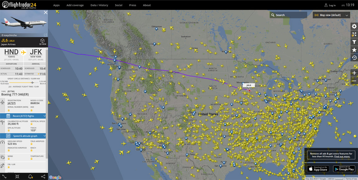
I looked into the actual flight data from an actual airplane - which flew from Los Angeles to Shanghai.
The reason was that there was a claim that planes flew along the west coast going from LA to China. So there will be planes going over Vancouver during such flights, at times.
Is this all true, or not?
It is true that the planes fly along the west coast.
However, this plane showed it flew MILES AWAY from the coastline.
It was nowhere near to Vancouver.
I found other examples, with the same result - no flights fly above Vancouver, or even close to it.
Anyway, YOU are the one claiming it is true, YOU must prove it.
So go ahead, already!
originally posted by: Zaphod58
a reply to: turbonium1
Try doing some research. That's not a flight path map, that was a snapshot of the FACET radar screen. Those were airborne aircraft at the time that was taken. It used real radar data for the evaluation of the technology.
I have been on far too many flights to even begin to remember what altitude or cities I flew over, so no, I'm not going to break it down for you. You'd probably just find an excuse to ignore it anyway.
This is total nonsense.
You first claim something to be true, and you spew out all the same crappy excuses, for not needing to show any proof.
I found many examples of it, and showed you one of them. And so far, they have proven that my claim is correct, as well.
And I didn't even make the original claim. YOU did.
It's easy to do, and I did it, so you have no excuse for not doing it, now.
Man up, for once.
a reply to: turbonium1
Admit you're wrong for once and stop hand waving away what you don't agree with. In 2016 there were 24,000 commercial flights over the US. And somehow every single flight managed to not fly over any city on its way over the US? Give me a break.
I could give you exactly what you asked for and you'd find some excuse for why it isn't good enough. No amount of proof will ever be good enough for you.
edit on 5/7/2017 by Zaphod58 because: (no reason given)
edit on 5/7/2017 by Zaphod58 because: (no reason given)
originally posted by: turbonium1
originally posted by: D8Tee
a reply to: turbonium1
Play around with this website.
Live Flight Tracker
Thanks for the link.
I looked into the actual flight data from an actual airplane - which flew from Los Angeles to Shanghai.
The reason was that there was a claim that planes flew along the west coast going from LA to China. So there will be planes going over Vancouver during such flights, at times.
Is this all true, or not?
It is true that the planes fly along the west coast.
However, this plane showed it flew MILES AWAY from the coastline.
It was nowhere near to Vancouver.
I found other examples, with the same result - no flights fly above Vancouver, or even close to it.
Anyway, YOU are the one claiming it is true, YOU must prove it.
So go ahead, already!
super, you tracked one flight. Now try that with about 100 of them. And then you can thin about the jet stream. Oh, and then you can try to imagine what happens to a contrail that is created 50 mile east of Vancouver when it's in the jet stream.
I'll give you a hint, think clouds.
But if you would just rather believe there is a grand conspiracy to spray you, go nuts. You won't be alone.
a reply to: network dude
I watched a contrail the other day that was left over Arizona. Over the course of five minutes it went from where it started, to about 45 degrees to the left, all while staying in a perfectly straight line.
I watched a contrail the other day that was left over Arizona. Over the course of five minutes it went from where it started, to about 45 degrees to the left, all while staying in a perfectly straight line.
a reply to: network dude
This was one of the few times I've watched a contrail move that radically and not get spread out. It was pretty interesting to watch. The winds must have been interesting at altitude to move that uniformly.
This was one of the few times I've watched a contrail move that radically and not get spread out. It was pretty interesting to watch. The winds must have been interesting at altitude to move that uniformly.
originally posted by: turbonium1
It was nowhere near to Vancouver.
I found other examples, with the same result - no flights fly above Vancouver, or even close to it.
Here is a video from a Chemtrail believer in Vancouver during 2014. He very kindly provides a map and info of the filming location/times, etc. He even indicates on the map of Vancouver where he believes that the aircraft are flying and leaving trails.
This is a very common error by chemtrail believers in that they totally misjudge distance.
The two flights are still available on flight tracking software playback. I used Planefinder.
Planefinder link
26 February 2014, Vancouver BC 2:30 pm.
14:30 Vancouver time = 22:30 GMT -8 GMT for that Winter period.
The two airliners that he is filming. They are in fact approximately 12 miles away from his filming location. Filming location denoted with yellow star.
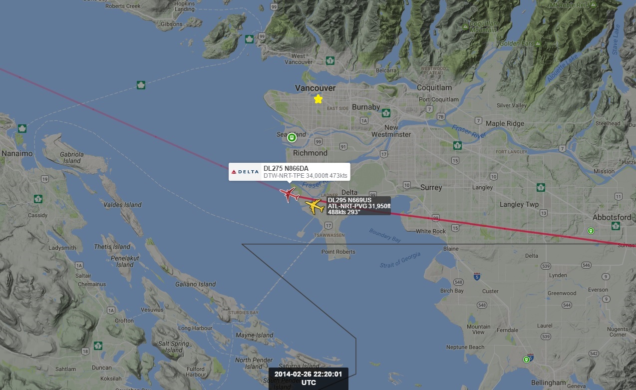
The two airliners are using the upper air routes and way points to the south of Vancouver.
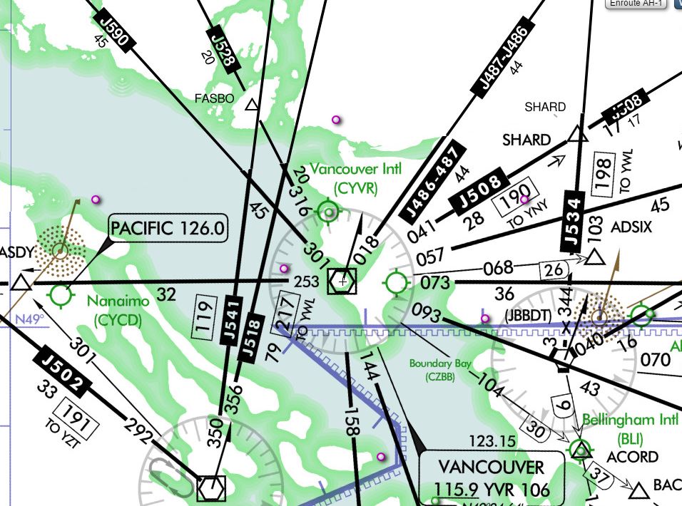
For Skyvector use the following link. Type in CVYR in the Flight Plan box on the upper left to centre the map on Vancouver. Ensure that the "World-Hi" is selected from the tab on the upper right.
Sky Vector Link
Delta 275 Boeing 777 is flying from Detroit to Taipei, Taiwan via Tokyo, Japan.
Delta 295 Boeing 747 is flying from Atlanta to Shanghai, China via Tokyo, Japan.
Excellent guide on judging contrail distance.
How Far Away is that Contrail link
Also notice that the chemtrail believer is puzzled by the "black lines" in front of the contrails.
Contrail Shadow link
Excellent work Tommyjo. I look forward to your points being ignored totally by the believers invested in the lies they have swallowed.
Yeah, great job. That's a lot of work to show basic flight paths.
I find it interesting that people have such a lack of basic geometry. See, if a jet is at 36,000 feet up, then it's about 6 nm in the air. If the horizon is 0 degrees and straight up is 90 degrees, then when you see an aircraft at about 45 degrees viewing angle, that puts him about 6 miles from your position (over the ground) but your slant angle is even longer (Thanks Pythagoras).
That's why they have to spray so much. The world is a big place.
a reply to: cosmania
It's my pet theory that there is a link between conspiracy belief and poor spatial awareness. There's the chemtrail believers, who often talk of planes "flying straight up" etc, or fail to find planes on radar because they are looking too close, as above.
Then there are the moon landing hoax crowd, who find "anomalies" in photos because they don't understand how perspective works, etc. Flat Earthers are another example, but we're going way off topic there.
It would be interesting to do a proper study of 3D perception versus affinity for conspiracy theories
originally posted by: network dude
originally posted by: turbonium1
originally posted by: D8Tee
a reply to: turbonium1
Play around with this website.
Live Flight Tracker
Thanks for the link.
I looked into the actual flight data from an actual airplane - which flew from Los Angeles to Shanghai.
The reason was that there was a claim that planes flew along the west coast going from LA to China. So there will be planes going over Vancouver during such flights, at times.
Is this all true, or not?
It is true that the planes fly along the west coast.
However, this plane showed it flew MILES AWAY from the coastline.
It was nowhere near to Vancouver.
I found other examples, with the same result - no flights fly above Vancouver, or even close to it.
Anyway, YOU are the one claiming it is true, YOU must prove it.
So go ahead, already!
super, you tracked one flight. Now try that with about 100 of them. And then you can thin about the jet stream. Oh, and then you can try to imagine what happens to a contrail that is created 50 mile east of Vancouver when it's in the jet stream.
I'll give you a hint, think clouds.
But if you would just rather believe there is a grand conspiracy to spray you, go nuts. You won't be alone.
I asked you to prove your claim.
Show me any actual flight to Asia which goes directly above Vancouver, if you can.
If you can't, your claim is worthless.
No excuses.
Is there actual flight data to support your claim?
You claimed it, so prove it, or admit you're wrong.
You claimed it, so prove it, or admit you're wrong.
originally posted by: turbonium1
originally posted by: network dude
originally posted by: turbonium1
originally posted by: D8Tee
a reply to: turbonium1
Play around with this website.
Live Flight Tracker
Thanks for the link.
I looked into the actual flight data from an actual airplane - which flew from Los Angeles to Shanghai.
The reason was that there was a claim that planes flew along the west coast going from LA to China. So there will be planes going over Vancouver during such flights, at times.
Is this all true, or not?
It is true that the planes fly along the west coast.
However, this plane showed it flew MILES AWAY from the coastline.
It was nowhere near to Vancouver.
I found other examples, with the same result - no flights fly above Vancouver, or even close to it.
Anyway, YOU are the one claiming it is true, YOU must prove it.
So go ahead, already!
super, you tracked one flight. Now try that with about 100 of them. And then you can thin about the jet stream. Oh, and then you can try to imagine what happens to a contrail that is created 50 mile east of Vancouver when it's in the jet stream.
I'll give you a hint, think clouds.
But if you would just rather believe there is a grand conspiracy to spray you, go nuts. You won't be alone.
I asked you to prove your claim.
Show me any actual flight to Asia which goes directly above Vancouver, if you can.
If you can't, your claim is worthless.
No excuses.
First of all, a plane does not need to be flying directly over a city to be easily seen from that city. A plane that is a ground distance of 20+ miles from you can be easily seen about halfway up in the sky.
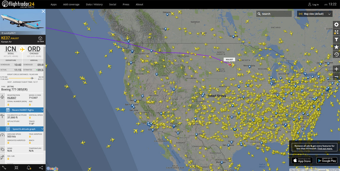
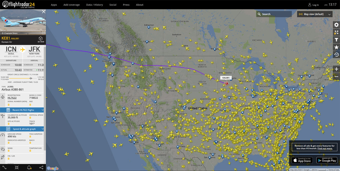
Here are three flights I found that were flying at the time I searched (and I'm sure there are more all the time). These flew about 15 to 20 miles south of Center-City Vancouver and a little more than 10 miles from Vancouver International Airport.
Seoul to Chicago:
Seoul to New York:
Tokyo to New York:
originally posted by: turbonium1
originally posted by: Soylent Green Is People
originally posted by: turbonium1
originally posted by: Zaphod58
a reply to: turbonium1
Contrary to what you apparently believe, flying from point A to point B in a straight line is NOT the most efficient way to get somewhere. The most efficient way to get there is to fly the great circle route. That means when flying to Beijing, you fly up the West Coast of the US, circle under Alaska, down the West Coast of Russia, and into China. It does NOT mean flying straight out over the Pacific, over Hawaii, to China. If they flew that route, they WOULD need more fuel.
I never said they all fly in a straight line. I said they fly from Point A to Point B, and no flight paths would go over the city I live in, whether it's a straight line, or a great circle. That's the problem here.
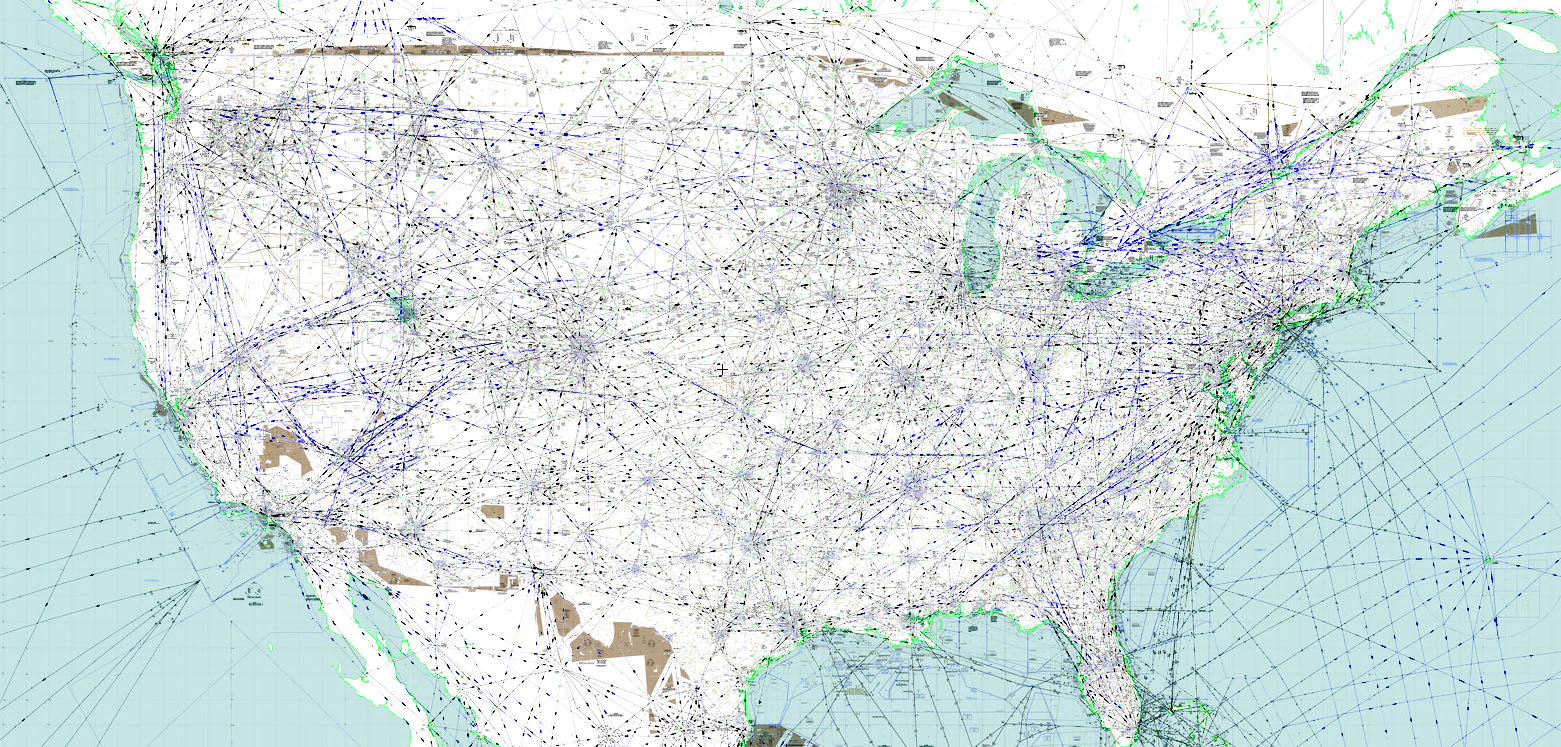
Flight vectors are over almost every place in the entire United States.
The map below shows the air vectors. These "roads" in the air can each be a few miles wide (i.e., accommodating several "lanes" for planes). Plus, at the height a plane flies, it could be seen flying over a spot on the ground up to 50 miles away from the observer.
skyvector.com...,-98.43310546770081&chart=304&zoom=10
This 'map' of lines 'blanketing' America.... good one!
Flight paths don't cover our skies like a blanket, as you would know.... right??...
So this 'map' is not to any scale, or depict specific flight paths of actual planes....
They cannot show actual routes of planes, on such a map.
Nonsense.
How about Seattle, WA, or Vancouver, BC ...
These cities edge the Pacific Ocean.
Both cities have international airports, and others for domestic flights, exclusively.
A flight to Asia will not go over these two cities enroute, because it would be completely off any of the flight paths, if starting from anywhere else.
Show us how YOU would plan a flight path then since you know better. If you can't then your claim is worthless and you'll have to admit you are wrong
originally posted by: mrthumpy
originally posted by: turbonium1
originally posted by: Soylent Green Is People
originally posted by: turbonium1
originally posted by: Zaphod58
a reply to: turbonium1
Contrary to what you apparently believe, flying from point A to point B in a straight line is NOT the most efficient way to get somewhere. The most efficient way to get there is to fly the great circle route. That means when flying to Beijing, you fly up the West Coast of the US, circle under Alaska, down the West Coast of Russia, and into China. It does NOT mean flying straight out over the Pacific, over Hawaii, to China. If they flew that route, they WOULD need more fuel.
I never said they all fly in a straight line. I said they fly from Point A to Point B, and no flight paths would go over the city I live in, whether it's a straight line, or a great circle. That's the problem here.
Flight vectors are over almost every place in the entire United States.
The map below shows the air vectors. These "roads" in the air can each be a few miles wide (i.e., accommodating several "lanes" for planes). Plus, at the height a plane flies, it could be seen flying over a spot on the ground up to 50 miles away from the observer.
skyvector.com...,-98.43310546770081&chart=304&zoom=10
This 'map' of lines 'blanketing' America.... good one!
Flight paths don't cover our skies like a blanket, as you would know.... right??...
So this 'map' is not to any scale, or depict specific flight paths of actual planes....
They cannot show actual routes of planes, on such a map.
Nonsense.
How about Seattle, WA, or Vancouver, BC ...
These cities edge the Pacific Ocean.
Both cities have international airports, and others for domestic flights, exclusively.
A flight to Asia will not go over these two cities enroute, because it would be completely off any of the flight paths, if starting from anywhere else.
Show us how YOU would plan a flight path then since you know better. If you can't then your claim is worthless and you'll have to admit you are wrong
Look at the ACTUAL flight paths from Atlanta or Detroit to Tokyo, on the flight finder link above. The actual planes fly NOWHERE NEAR VANCOUVER.
These are the very same planes being claimed to fly 12 miles south of Vancouver. Making up a 'map' does not exactly constitute proof, of any kind.
Just woke up, have not had time to sift through the whole thread just going to drop a question and ill get back to it when I am feeling alive.
To the OP...I have flown on various large multi-engine aircraft for the USAF for nearly 20 years...which air frames do folks believe are doing this?
To the OP...I have flown on various large multi-engine aircraft for the USAF for nearly 20 years...which air frames do folks believe are doing this?
new topics
-
Putin, Russia and the Great Architects of the Universe
ATS Skunk Works: 1 hours ago -
A Warning to America: 25 Ways the US is Being Destroyed
New World Order: 6 hours ago
top topics
-
President BIDEN's FBI Raided Donald Trump's Florida Home for OBAMA-NORTH KOREA Documents.
Political Conspiracies: 12 hours ago, 29 flags -
A Warning to America: 25 Ways the US is Being Destroyed
New World Order: 6 hours ago, 12 flags -
Las Vegas UFO Spotting Teen Traumatized by Demon Creature in Backyard
Aliens and UFOs: 17 hours ago, 7 flags -
Is AI Better Than the Hollywood Elite?
Movies: 13 hours ago, 3 flags -
Maestro Benedetto
Literature: 13 hours ago, 1 flags -
Putin, Russia and the Great Architects of the Universe
ATS Skunk Works: 1 hours ago, 1 flags
active topics
-
Gaza Terrorists Attack US Humanitarian Pier During Construction
Middle East Issues • 40 • : WeMustCare -
Cats Used as Live Bait to Train Ferocious Pitbulls in Illegal NYC Dogfighting
Social Issues and Civil Unrest • 24 • : NoviceStoic4 -
A Warning to America: 25 Ways the US is Being Destroyed
New World Order • 13 • : 2025yuga -
Is AI Better Than the Hollywood Elite?
Movies • 19 • : GENERAL EYES -
University of Texas Instantly Shuts Down Anti Israel Protests
Education and Media • 271 • : CriticalStinker -
Weinstein's conviction overturned
Mainstream News • 27 • : brodby -
ChatGPT Beatles songs about covid and masks
Science & Technology • 24 • : iaylyan -
The Acronym Game .. Pt.3
General Chit Chat • 7754 • : bally001 -
Nearly 70% Of Americans Want Talks To End War In Ukraine
Political Issues • 96 • : andy06shake -
Rupert Murdoch engaged at 92
People • 8 • : brodby