It looks like you're using an Ad Blocker.
Please white-list or disable AboveTopSecret.com in your ad-blocking tool.
Thank you.
Some features of ATS will be disabled while you continue to use an ad-blocker.

I was in Palmdale and the Chem-trail pollution was off the charts
page: 9share:
originally posted by: turbonium1
originally posted by: Zaphod58
a reply to: turbonium1
Contrary to what you apparently believe, flying from point A to point B in a straight line is NOT the most efficient way to get somewhere. The most efficient way to get there is to fly the great circle route. That means when flying to Beijing, you fly up the West Coast of the US, circle under Alaska, down the West Coast of Russia, and into China. It does NOT mean flying straight out over the Pacific, over Hawaii, to China. If they flew that route, they WOULD need more fuel.
I never said they all fly in a straight line. I said they fly from Point A to Point B, and no flight paths would go over the city I live in, whether it's a straight line, or a great circle. That's the problem here.
Is there websites or software where you can track all the commercial traffic?
I remember seeing something like that, anyone have a link?
a reply to: turbonium1
Yes they would. Depending on where they originate from they're going to go over just about everywhere.
Yes they would. Depending on where they originate from they're going to go over just about everywhere.
originally posted by: turbonium1
originally posted by: Zaphod58
a reply to: turbonium1
Contrary to what you apparently believe, flying from point A to point B in a straight line is NOT the most efficient way to get somewhere. The most efficient way to get there is to fly the great circle route. That means when flying to Beijing, you fly up the West Coast of the US, circle under Alaska, down the West Coast of Russia, and into China. It does NOT mean flying straight out over the Pacific, over Hawaii, to China. If they flew that route, they WOULD need more fuel.
I never said they all fly in a straight line. I said they fly from Point A to Point B, and no flight paths would go over the city I live in, whether it's a straight line, or a great circle. That's the problem here.
Flight vectors are over almost every place in the entire United States.
The map below shows the air vectors. These "roads" in the air can each be a few miles wide (i.e., accommodating several "lanes" for planes). Plus, at the height a plane flies, it could be seen flying over a spot on the ground up to 50 miles away from the observer.
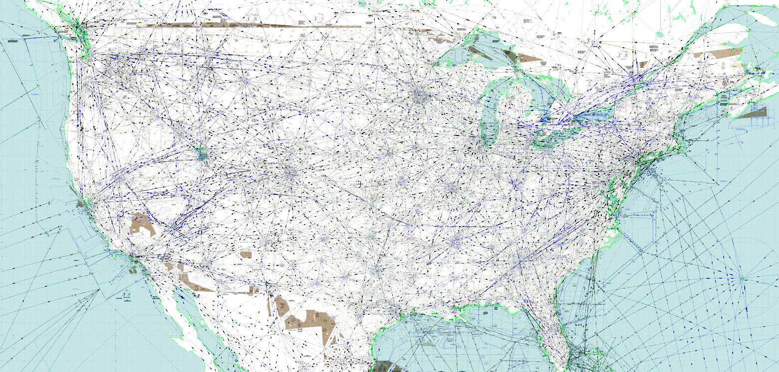
skyvector.com...,-98.43310546770081&chart=304&zoom=10
edit on 19/3/2017 by Soylent Green Is People because: (no
reason given)
originally posted by: turbonium1
So many planes keep on flying above every major city around the world, day after day, while each and every one of these planes always leaves a contrail, simply doesn't wash.
You cannot remove the environmental factors required, which aren't present each and every day, around the world, right?
You have another excuse, which is engines make the contrails now, in most any type of environment...
Of course, no proof for this claim, to excuse it all away..
Planes would not be flying in every direction, going nowhere,
Some of these planes are going directly west, to the vast Pacific Ocean...!!
Where could these planes possibly land, is the real question...
They are flying over an international airport, but none of them need more fuel in crossing the Pacific!
Why are the planes above the city, all the time? No reason, flying over cities is just for fun!!
If you re-read your post here, it seems an awful lot like you just are missing some key pieces of information here and you fill that in with paranoia. If you do the due diligence and investigate the questions you brought up in your post, you will find answers that show you nothing nefarious is happening.
And for you I will re-iterate a guarantee I offered before, wherever you see persistent trails, the conditions for those trails to exist are perfect for those trails in the sky they exist in, guaranteed. If you have trails, and can prove the conditions aren't favorable for trails to form, at the exact altitude the trails exist, then you would have the proverbial smoking gun. And if you study a bit, you can learn how to check those facts for yourself.
edit on 19-3-2017 by network dude because: in
originally posted by: fema1
a reply to: anonentity
This guys explains Chem vs. Con!
Wait -- is he implying that clouds are scientifically impossible, too?
Around the 6:00 mark, he tries to explain how contrails cannot stretch across the horizon and spread because contrails are condensation, and condensation cannot last a long time in warm atmosphere (emphasis on "tries", because he doesn't give any evidence, but rather simply makes an unsubstantiated statement).
Well, that's kind of a silly argument, since clouds are condensation (visible droplets of water condensed out of the invisible water vapor in the air) and clouds can certainly last for a long time. Furthermore, almost all contrails happen at 30,000 feet and above, at which the atmosphere is very cold (about -40 degrees F). At that temperature, the invisible gaseous water vapor that condenses to forms visible ice crystal contrails -- just like cirrus clouds, which can last for hours, are ice crystals condensed out of the air.
So how does his silly and illogical statement that "condensation cannot possibly last that long" explain clouds? Unless of course he thinks clouds do not exist.
Fema1 -- Instead of blindly believing everything you read or hear on the internet (even the stuff I said above), please take some time to actually try to understand what the person is saying to confirm that it makes scientific sense.
edit on 20/3/2017 by Soylent Green Is People because: (no reason given)
originally posted by: turbonium1
I never said they all fly in a straight line. I said they fly from Point A to Point B, and no flight paths would go over the city I live in, whether it's a straight line, or a great circle. That's the problem here.
Really? So prove it then and name the city. Do you really understand the air picture in your region?
www.flightradar24.com...
planefinder.net...
Use the playback in the above flight tracking links and study the data.
Or use the apps and monitor the air picture while you are outdoors.
play.google.com...
itunes.apple.com...
Also take into consideration just how far away a contrail can be seen.
contrailscience.com...
edit on 22/3/2017 by tommyjo because: spelling
originally posted by: Soylent Green Is People
originally posted by: turbonium1
originally posted by: Zaphod58
a reply to: turbonium1
Contrary to what you apparently believe, flying from point A to point B in a straight line is NOT the most efficient way to get somewhere. The most efficient way to get there is to fly the great circle route. That means when flying to Beijing, you fly up the West Coast of the US, circle under Alaska, down the West Coast of Russia, and into China. It does NOT mean flying straight out over the Pacific, over Hawaii, to China. If they flew that route, they WOULD need more fuel.
I never said they all fly in a straight line. I said they fly from Point A to Point B, and no flight paths would go over the city I live in, whether it's a straight line, or a great circle. That's the problem here.
Flight vectors are over almost every place in the entire United States.
The map below shows the air vectors. These "roads" in the air can each be a few miles wide (i.e., accommodating several "lanes" for planes). Plus, at the height a plane flies, it could be seen flying over a spot on the ground up to 50 miles away from the observer.
skyvector.com...,-98.43310546770081&chart=304&zoom=10
This 'map' of lines 'blanketing' America.... good one!
Flight paths don't cover our skies like a blanket, as you would know.... right??...
So this 'map' is not to any scale, or depict specific flight paths of actual planes....
They cannot show actual routes of planes, on such a map.
Nonsense.
How about Seattle, WA, or Vancouver, BC ...
These cities edge the Pacific Ocean.
Both cities have international airports, and others for domestic flights, exclusively.
A flight to Asia will not go over these two cities enroute, because it would be completely off any of the flight paths, if starting from anywhere else.
a reply to: turbonium1
Wrong again. Flights out of LA, San Francisco, San Diego, Las Vegas, Dallas going to anywhere in Asia will go over both those cities. They all go up to just south of Alaska before turning west and heading down along the Russian coastline and heading into Asia.
Wrong again. Flights out of LA, San Francisco, San Diego, Las Vegas, Dallas going to anywhere in Asia will go over both those cities. They all go up to just south of Alaska before turning west and heading down along the Russian coastline and heading into Asia.
a reply to: turbonium1
This was taken from the main FAA radar screen, in July 2006,when air traffic was down.
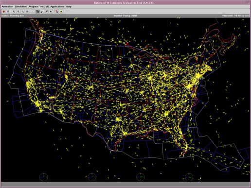
Air traffic covers the skies whether you realize it or not. An average day over the US, counting all aviation classes, sees somewhere around 90,000 flights a day. Worldwide, there are somewhere between 130,000 and 150,000 commercial flights every day.
This was taken from the main FAA radar screen, in July 2006,when air traffic was down.
Air traffic covers the skies whether you realize it or not. An average day over the US, counting all aviation classes, sees somewhere around 90,000 flights a day. Worldwide, there are somewhere between 130,000 and 150,000 commercial flights every day.
originally posted by: Zaphod58
a reply to: turbonium1
Wrong again. Flights out of LA, San Francisco, San Diego, Las Vegas, Dallas going to anywhere in Asia will go over both those cities. They all go up to just south of Alaska before turning west and heading down along the Russian coastline and heading into Asia.
No.
They have no need to fly directly over those cities when enroute to Asia. Only flights from San Diego might fly over LA, because they are close to each other, and on the coast. That is it, though.
Why would a flight from Dallas need to fly directly over any of these cities? That's absurd.
a reply to: turbonium1
According to whom? Define "need."
They have no need to fly directly over those cities when enroute to Asia
Some previous ATS threads on Chemtrails containing excellent information (IMO of course) both belief and skepticism. Read all of the replies, or at
least those with the most substantive information.
www.abovetopsecret.com...
www.abovetopsecret.com...
www.abovetopsecret.com...
www.abovetopsecret.com...
I know some will see the word "debunk" in those topic titles and want to dismiss them, but if you truly believe in the existence of Chemtrails, I feel it behooves one to look as objectively as possible at all of the evidence and then if you still believe, that's your prerogative and I respect your right to believe as you wish, and have no desire to debate it or change your mind. But the previous topics are a great reference, again, IMHO.
Peace.
www.abovetopsecret.com...
www.abovetopsecret.com...
www.abovetopsecret.com...
www.abovetopsecret.com...
I know some will see the word "debunk" in those topic titles and want to dismiss them, but if you truly believe in the existence of Chemtrails, I feel it behooves one to look as objectively as possible at all of the evidence and then if you still believe, that's your prerogative and I respect your right to believe as you wish, and have no desire to debate it or change your mind. But the previous topics are a great reference, again, IMHO.
Peace.
edit on 3/26/2017 by AceWombat04 because: Typo
a reply to: turbonium1
I didn't say they'd fly over those cities, I said flights from those cities will be seen over the Seattle/BC area. Because, again, it's called the great circle route. To get to Asia from the US, you don't just fly out over the Pacific and head towards Asia. You fly from where you're starting, head up towards Alaska, and down along Russia, and into Asia, wherever you're heading. So a flight from Dallas to Tokyo would head north, up over the Seattle and British Columbia area, go out over the Bering Sea, just south of Alaska, and down along the Kamchatka Peninsula, in to Tokyo.
It all depends on winds. Flights from the West Coast will sometimes head out early over the Pacific, sometimes they stay closer to shore, until they get higher on the route. Flights from further in, such as Dallas, frequently head up and go directly over Alaska, all depending on winds. The stronger the wind, the more the flights curve to stay out of them when they're going West. Coming East, they fly a more direct route to take advantage of the winds.
edit on 3/26/2017 by Zaphod58 because: (no reason given)
new topics
-
The functionality of boldening and italics is clunky and no post char limit warning?
ATS Freshman's Forum: 40 minutes ago -
Meadows, Giuliani Among 11 Indicted in Arizona in Latest 2020 Election Subversion Case
Mainstream News: 1 hours ago -
Massachusetts Drag Queen Leads Young Kids in Free Palestine Chant
Social Issues and Civil Unrest: 1 hours ago -
Weinstein's conviction overturned
Mainstream News: 2 hours ago -
Supreme Court Oral Arguments 4.25.2024 - Are PRESIDENTS IMMUNE From Later Being Prosecuted.
Above Politics: 4 hours ago -
Krystalnacht on today's most elite Universities?
Social Issues and Civil Unrest: 4 hours ago -
Chris Christie Wishes Death Upon Trump and Ramaswamy
Politicians & People: 4 hours ago -
University of Texas Instantly Shuts Down Anti Israel Protests
Education and Media: 7 hours ago -
Any one suspicious of fever promotions events, major investor Goldman Sachs card only.
The Gray Area: 9 hours ago
top topics
-
Krystalnacht on today's most elite Universities?
Social Issues and Civil Unrest: 4 hours ago, 8 flags -
Weinstein's conviction overturned
Mainstream News: 2 hours ago, 6 flags -
Supreme Court Oral Arguments 4.25.2024 - Are PRESIDENTS IMMUNE From Later Being Prosecuted.
Above Politics: 4 hours ago, 5 flags -
Electrical tricks for saving money
Education and Media: 16 hours ago, 5 flags -
University of Texas Instantly Shuts Down Anti Israel Protests
Education and Media: 7 hours ago, 5 flags -
Meadows, Giuliani Among 11 Indicted in Arizona in Latest 2020 Election Subversion Case
Mainstream News: 1 hours ago, 3 flags -
Chris Christie Wishes Death Upon Trump and Ramaswamy
Politicians & People: 4 hours ago, 2 flags -
Any one suspicious of fever promotions events, major investor Goldman Sachs card only.
The Gray Area: 9 hours ago, 2 flags -
Massachusetts Drag Queen Leads Young Kids in Free Palestine Chant
Social Issues and Civil Unrest: 1 hours ago, 2 flags -
God's Righteousness is Greater than Our Wrath
Religion, Faith, And Theology: 13 hours ago, 1 flags
active topics
-
University of Texas Instantly Shuts Down Anti Israel Protests
Education and Media • 161 • : PorkChop96 -
Supreme Court Oral Arguments 4.25.2024 - Are PRESIDENTS IMMUNE From Later Being Prosecuted.
Above Politics • 53 • : network dude -
The functionality of boldening and italics is clunky and no post char limit warning?
ATS Freshman's Forum • 5 • : CarlLaFong -
Weinstein's conviction overturned
Mainstream News • 19 • : Vermilion -
Candidate TRUMP Now Has Crazy Judge JUAN MERCHAN After Him - The Stormy Daniels Hush-Money Case.
Political Conspiracies • 762 • : Oldcarpy2 -
-@TH3WH17ERABB17- -Q- ---TIME TO SHOW THE WORLD--- -Part- --44--
Dissecting Disinformation • 675 • : Thoughtful3 -
Meadows, Giuliani Among 11 Indicted in Arizona in Latest 2020 Election Subversion Case
Mainstream News • 3 • : network dude -
Any one suspicious of fever promotions events, major investor Goldman Sachs card only.
The Gray Area • 9 • : xuenchen -
President BIDEN Vows to Make Americans Pay More Federal Taxes in 2025 - Political Suicide.
2024 Elections • 145 • : ImagoDei -
Massachusetts Drag Queen Leads Young Kids in Free Palestine Chant
Social Issues and Civil Unrest • 7 • : nugget1