It looks like you're using an Ad Blocker.
Please white-list or disable AboveTopSecret.com in your ad-blocking tool.
Thank you.
Some features of ATS will be disabled while you continue to use an ad-blocker.

Why is the Sun Setting North of Due West? - I Am Above The Tropic of Cancer
page: 4share:
originally posted by: cooperton
If you can find me a diagram of the celestial objects as spheres, with proper proportions, that makes sense of a northwest sunset for an observer above the tropic of cancer I will concede. Forever
Well actually, the fact that the sun sets in the northwest in summer anywhere in the northern hemisphere (the further north you are, the further north it sets) is strong evidence that the Earth is a sphere.
Only if the Earth was flat could the Sun rise and set due east and west all year round.
So you have, by direct observation, proven that the Earth is a sphere
a reply to: cooperton
Yes. YOUR horizon is a flat plane! The earth isn't, but your horizon is!
You find the picture. The onus isn't on us to provide one. You must surely realise that the whole concept of the image you are asking for is absurd. The relative sizes and distances involved mean you wouldn't be able to represent the scale values in any reasonable space. The sun alone is 92 million miles away. The other stars, due to their sheer distance act like fixed objects in relation to one another. Even through the most powerful telescope you can buy: a star still just looks like a single point of light. The distances involved are too vast for anything else to be observed using home gear. The diagrams used play with scale in order to illustrate CONCEPTS not the exact reality.
Regardless of what you, and some others may be trying to posit, the sun has not changed position in any meaningful way in at least half a century that I personally have verified. For copyright purposes we make heavy use of a 1977 nautical almanac when teaching our cadets celestial navigation. The figures still work to a very good level of faculty now. A competent student will be able to position himself within a nautical mile using a sextant, an almanac and a calculator using formulae that have been in use unchanged for centuries.
a reply to: cooperton
and whoosh - the goal posts move - great
but seriously all you have to do is mark on that diagram where :
perth [ australia ] - east 116 , south 32
Hu Nan Zhuang,[ PRC ] east 116 - north 32
are - simples
as observers at both locations [ at noon on june 21st ]
the observer in china will see the sun at its highest non position of the year
the observer in perth will see the sun at its lowest noon position of the year
explain that using flat earth science
just do it - or concede - i dont want sume silly " couter challege " - this is nailing flat earthers feet to the deck
put up or concede
originally posted by: cooperton
originally posted by: eriktheawful
a reply to: cooperton
Did you take a look at the image I posted?
It does what you are asking about because of the Earth's fixed 23 degree tilt as it rotates around the sun.
Yes, but that diagram you showed uses a flat earth to demonstrate that. Is this what you are saying?
From the perspective of the person standing on the Earth, the ground does look flat, not curved.
You have been shown with several images why the sun will set north of due west during the summer months if you are at 40 N Lat. It's been explained why this happens (the Earth's 23 degree tilt and orbit around the sun).
The diagram showing the ground being flat will not change the behavior of how the sun looks from the surface of the Earth as it orbits about the sun at a 23 degree tilt.
I can lead you to the lake of knowledge, but I can't make you drink from it.
originally posted by: eriktheawful
Did you take a look at the image I posted?l
I can lead you to the lake of knowledge, but I can't make you drink from it.
Amen brother. It took me 3 years of teaching and a near nervous breakdown to finally accept the truth of that statement.
This document is very formulae heavy, but the early chapters on positions log and the one or rising/setting are worth a read.
www.fabiopeixoto.com...
To be fair, the OP isn't saying the Earth is flat (which it shockingly obviously isn't), they were just asking about something they had observed due
to not having the right idea as to what the tropics of cancer / capricorn are.
edit on 24-7-2015 by Vasteel because: (no reason given)
originally posted by: ignorant_ape
a reply to: cooperton
and whoosh - the goal posts move - great
but seriously all you have to do is mark on that diagram where :
perth [ australia ] - east 116 , south 32
Hu Nan Zhuang,[ PRC ] east 116 - north 32
are - simples
as observers at both locations [ at noon on june 21st ]
the observer in china will see the sun at its highest non position of the year
the observer in perth will see the sun at its lowest noon position of the year
explain that using flat earth science
just do it - or concede - i dont want sume silly " couter challege " - this is nailing flat earthers feet to the deck
put up or concede
I never claimed that the earth is a simple flat object. I am not equating the earth to a dinner plate, bear with me. Rather, I am arguing that they are not simple spheres. Again, please do not bring arguments against a simple flat earth, because this is not what I am trying to express.
If you don't have any of the following stuff you can just visualize in your head what I am about to describe. Take out a globe (must be at least the size of a cantaloupe). For this example lets use the 40th latitude. Put sticks (any long and straight object) all along the 40th latitude line and make sure they are pointing directly away from the globe. This will represent the east-west 40th latitude line: anything observed above these sticks will be north, and anything below will be south. This is nothing new, and it is just for purposes of observation. Get some object, such as a Ping-Pong ball, to be the sun (I know this is not to scale, but all we need to know is where the sun's location is: a to-scale model would work for this demonstration too, but for convenience sake use a smaller object). Tilt the globe 23 degrees towards the ping pong ball to emulate the summer solstice. The core of the globe, the 23rd latitude line, and the Ping-Pong ball should all be aligned. Now, No matter how close or far you move the ping-pong ball to the globe within the confines of this alignment, it will never appear to be north of the 40th latitude sticks.
But, the sun, in real life, DOES appear to set north of the 40th latitude line in the midst of summer.
edit on 24-7-2015 by cooperton because: (no reason given)
originally posted by: eriktheawful
a reply to: cooperton
Your question has been answered several times in this thread.
Do the demonstration I described. The sun, according to the simple spherical model (contemporary astronomical model), should never be observed to be north of the tropic of cancer. If you replicate the experiment I described you will see this clearly.
edit on 24-7-2015 by cooperton because: (no reason given)
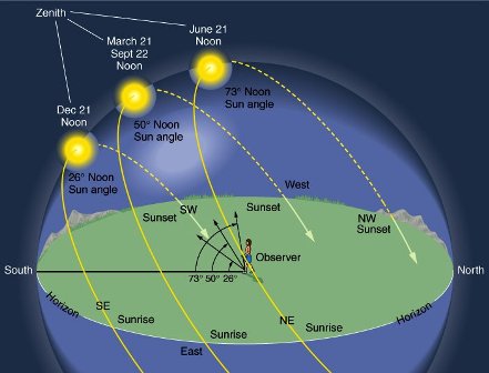
The only dates when the sun rises and sets due east and west are the spring and fall equinoxes: March 21 and September 21 (the exact times vary and they can fall on the 20th as well).
Between March 21 and September 21, the Sun is north of the celestial equator. It rises north of due east and sets north of due west.
The closer to the Summer Solstice (June 21) and the farther north you go, the greater the deviation from due east and west.
At 50 N the sun can deviate from due east and west by 38 degrees, and at 60 N the deviation can be 53 degrees. Just south of the Arctic Circle on June 21, the sun sets almost due north, dips briefly below the horizon, and rises again almost due north. On December 21, it peeps above the horizon almost due south and then drops back below, again almost due south.
See this
a reply to: cooperton
Okay, let's work with that globe and go further. Grab a lamp to represent the sun. Place it in such a way that it lights half the globe and you have an obvious terminator line. If you then tilt the globe 23.5 degrees directly towards the lamp, you will see that the terminator line doesn't run directly north and south anymore. It runs diagonally across the globe.
If you have a laser level you could use that to highlight the 40 degree parallel and you will see the angle it forms. That angle will be equivalent to to how far to the north of East the sun will rise.
As an aside, the earth isn't a sphere. That is scientifically accepted. It is an oblate spheroid. That's why navigation over long distances can't be calculated with simple trigonometry but requires the use of meridional parts.
originally posted by: cheesyleps
a reply to: cooperton
If you have a laser level you could use that to highlight the 40 degree parallel and you will see the angle it forms. That angle will be equivalent to to how far to the north of East the sun will rise.
No, you could not, the lines of latitude are not parallel.
In spherical geometry, parallel lines do not occur.
This is why it is important that you do this demonstration. You will see that the light source (the lamp, which you called it) is never north of the sticks placed along the 40th parallel. Therefore, if they are in fact spheres (approximately), the sun should never be observed to be north of the tropic of cancer.
It is hard to picture in your head, that is why you should set this up experimentally as I described.
originally posted by: roadgravel
Just south of the Arctic Circle on June 21, the sun sets almost due north, dips briefly below the horizon, and rises again almost due north. On December 21, it peeps above the horizon almost due south and then drops back below, again almost due south.
YES! Everyone, please, think this one through.
On December 21 (the winter solstice) when the north pole is angled away from the sun, an observer standing near the north pole SHOULD (key word "should"), should NEVER be able to see the sun. Watch theoretical videos of the earth's orbit around the sun, you'll note that around December 21 the earth is angled in a way that the north pole should not see the sun, at all. but, ACTUALLY, "it peeps above the horizon almost due south and then drops back below, again almost due south"
originally posted by: cooperton
originally posted by: roadgravel
Just south of the Arctic Circle on June 21, the sun sets almost due north, dips briefly below the horizon, and rises again almost due north. On December 21, it peeps above the horizon almost due south and then drops back below, again almost due south.
YES! Everyone, please, think this one through.
On December 21 (the winter solstice) when the north pole is angled away from the sun, an observer standing near the north pole SHOULD (key word "should"), should NEVER be able to see the sun. Watch theoretical videos of the earth's orbit around the sun, you'll note that around December 21 the earth is angled in a way that the north pole should not see the sun, at all. but, ACTUALLY, "it peeps above the horizon almost due south and then drops back below, again almost due south"
The post you quoted says "Just South of the arctic circle...", not "At the North Pole...". At the pole then the Sun would never be above the horizon on Dec 21st, as you point out yourself.
edit on 24-7-2015 by Vasteel because: (no reason given)
originally posted by: Vasteel
originally posted by: cooperton
originally posted by: roadgravel
Just south of the Arctic Circle on June 21, the sun sets almost due north, dips briefly below the horizon, and rises again almost due north. On December 21, it peeps above the horizon almost due south and then drops back below, again almost due south.
YES! Everyone, please, think this one through.
On December 21 (the winter solstice) when the north pole is angled away from the sun, an observer standing near the north pole SHOULD (key word "should"), should NEVER be able to see the sun. Watch theoretical videos of the earth's orbit around the sun, you'll note that around December 21 the earth is angled in a way that the north pole should not see the sun, at all. but, ACTUALLY, "it peeps above the horizon almost due south and then drops back below, again almost due south"
The post you quoted says "Just South of the arctic circle...", not "At the North Pole...". At the pole then the Sun would never be above the horizon on Dec 21st, as you point out yourself.
Thank you for catching the semantic slip. *just south of the arctic circle* on December 21st... how is the sun rising above the horizon when the north pole is angled away from the sun at its full 23.4 degrees?
originally posted by: cooperton
originally posted by: cheesyleps
a reply to: cooperton
If you have a laser level you could use that to highlight the 40 degree parallel and you will see the angle it forms. That angle will be equivalent to to how far to the north of East the sun will rise.
No, you could not, the lines of latitude are not parallel.
In spherical geometry, parallel lines do not occur.
This is exactly where you are going wrong, as I explained to you earlier. Read the pdf link I posted or hell, even read this wikipedia page: en.wikipedia.org...
Lines of latitude ARE PARALLEL TO EACH OTHER! They are even named as "Parallels of Latitude". Longitudinal lines are not parallel, but latitudinal lines are.
You are labouring under the impression that east is an absolute reference towards a point on a sphere, it isn't, it is a directional reference. What is due east of me is very different to what is due east of you.
Please do me a favour Cooperton, take a bit of time to read up on the basics of terrestrial and celestial co-ordinate systems. Ignoring the advice I give isn't going to resolve your misunderstanding.
This is a time lapse video shot from a geostationary satellite at the same time every day for a year.
www.youtube.com...
If you draw a horizontal line across any point on the orb you will have a parallel of latitude. Notice how the angle between it and the terminator line changes over the course of the year. The sun appears to an observe to be at a point in the sky perpendicular to that terminator line.
That perpendicular line is essentially a line of position. Ships have used the sun to find LOP for hundreds of years. The simplest time to do so is at local noon (known as a meridional passage). When the sun passes directly over your local meridian (when it reaches its zenith or highest point in the sky) then the line of position it creates on the earth is perpendicular to the meridian. ie. it is a simple line of latitude. If we assume the sun has a declination of zero (ie it is directly above the equator) then it is very easy to find latitude as it is the co-altitude of the sun (if you were stood on the equator you would measure the altitude of the sun as 90 degrees. 90-90=0. 0 degrees latitude. Move 20 degrees north and you will observe the sun at an altitude of 70 degrees. 90-70=20).
Incorporating declination into things makes it a touch trickier as the sun isn't over the 0 point now. Lets say the sun is 10 degrees north. If you stand at 10 degrees north you will now have the sun overhead, therefore 20 degrees is now only 10 degrees away from the sun and would observe at 80. You have had to subtract the sun's declination from your calculation. If you were in the southern hemisphere you would have to ADD the declination to this, resulting in a sun lower in the sky.
What I am getting at is that your posit about it not being possible to see the sun north of you if your latitude is more northerly than the declination is absolutely correct but only in reference to the MERIDIONAL PASSAGE. This is all down to the combination of the visible horizon being a flat plane around an observer's position and the fact that the co-ordinates system is NOT fully based upon spherical geometry. NORTH is a real reference. SOUTH is a real reference. EAST and WEST are simply angular measurements from those real reference points. If EAST was always referring to a point on the equator known as the east pole then what you say would be perfectly correct. That just isn't the case though.
edit on 24/7/15 by
cheesyleps because: Forgot the link to the video
originally posted by: Astyanax
a reply to: Nyiah
WTH is so wrong with America today that people either forget or don't understand basic science?
I wouldn't judge America's scientific knowledge by the OP's.
He's posted threads here suggesting that
— dragons are dinosaurs and dinosaurs are Satan
— viruses are demons
— Genesis describes the Big Bang
— There is a layer of glass in the sky above us, holding in the atmosphere
A somewhat unique case, I think.
Which variety ? Basket. There seems to be a whole tribe around here these days. The flat earthers have really got me wondering about the sanity of the human race.
originally posted by: cooperton
originally posted by: roadgravel
Just south of the Arctic Circle on June 21, the sun sets almost due north, dips briefly below the horizon, and rises again almost due north. On December 21, it peeps above the horizon almost due south and then drops back below, again almost due south.
YES! Everyone, please, think this one through.
On December 21 (the winter solstice) when the north pole is angled away from the sun, an observer standing near the north pole SHOULD (key word "should"), should NEVER be able to see the sun. Watch theoretical videos of the earth's orbit around the sun, you'll note that around December 21 the earth is angled in a way that the north pole should not see the sun, at all. but, ACTUALLY, "it peeps above the horizon almost due south and then drops back below, again almost due south"
That can be naturally explained by the refraction issue, but is also addressed by Vasteel below. When you see the sun dip below the horizon, it is actually already well below it. The refractive effects of the atmosphere at the horizon cause bending of light waves, showing the sun to be higher in the sky than it really is. This is the difference between the visual horizon and the celestial horizon. In order to measure the sun's azimuth or amplitude at sunset the rule of thumb is to measure when it is a semi-diameter above the visible horizon as illustrated here:
image.slidesharecdn.com...
Here, read this. It's pretty simplistic, so most of your questions should be easily answered.
www.math.nus.edu.sg...
Either admit you're having a real rough time grasping basic science, or that you're just pulling a fast one on the members here.
www.math.nus.edu.sg...
Either admit you're having a real rough time grasping basic science, or that you're just pulling a fast one on the members here.
new topics
-
BIDEN Admin Begins Planning For January 2025 Transition to a New President - Today is 4.26.2024.
2024 Elections: 3 hours ago -
Big Storms
Fragile Earth: 4 hours ago -
Where should Trump hold his next rally
2024 Elections: 7 hours ago -
Shocking Number of Voters are Open to Committing Election Fraud
US Political Madness: 8 hours ago -
Gov Kristi Noem Shot and Killed "Less Than Worthless Dog" and a 'Smelly Goat
2024 Elections: 8 hours ago -
Falkville Robot-Man
Aliens and UFOs: 9 hours ago -
James O’Keefe: I have evidence that exposes the CIA, and it’s on camera.
Whistle Blowers and Leaked Documents: 9 hours ago -
Australian PM says the quiet part out loud - "free speech is a threat to democratic dicourse"...?!
New World Order: 10 hours ago -
Ireland VS Globalists
Social Issues and Civil Unrest: 10 hours ago -
Biden "Happy To Debate Trump"
2024 Elections: 11 hours ago
top topics
-
James O’Keefe: I have evidence that exposes the CIA, and it’s on camera.
Whistle Blowers and Leaked Documents: 9 hours ago, 17 flags -
Australian PM says the quiet part out loud - "free speech is a threat to democratic dicourse"...?!
New World Order: 10 hours ago, 15 flags -
Blast from the past: ATS Review Podcast, 2006: With All Three Amigos
Member PODcasts: 13 hours ago, 13 flags -
Biden "Happy To Debate Trump"
2024 Elections: 11 hours ago, 13 flags -
Ireland VS Globalists
Social Issues and Civil Unrest: 10 hours ago, 9 flags -
Mike Pinder The Moody Blues R.I.P.
Music: 13 hours ago, 8 flags -
BIDEN Admin Begins Planning For January 2025 Transition to a New President - Today is 4.26.2024.
2024 Elections: 3 hours ago, 7 flags -
What is the white pill?
Philosophy and Metaphysics: 13 hours ago, 6 flags -
Shocking Number of Voters are Open to Committing Election Fraud
US Political Madness: 8 hours ago, 6 flags -
Big Storms
Fragile Earth: 4 hours ago, 6 flags
active topics
-
Big Storms
Fragile Earth • 16 • : rickymouse -
James O’Keefe: I have evidence that exposes the CIA, and it’s on camera.
Whistle Blowers and Leaked Documents • 14 • : 19Bones79 -
BIDEN Admin Begins Planning For January 2025 Transition to a New President - Today is 4.26.2024.
2024 Elections • 18 • : rickymouse -
RAAF airbase in Roswell, New Mexico is on fire
Aliens and UFOs • 12 • : pianopraze -
A Warning to America: 25 Ways the US is Being Destroyed
New World Order • 29 • : 19Bones79 -
What is the white pill?
Philosophy and Metaphysics • 22 • : AlexandrosOMegas -
University of Texas Instantly Shuts Down Anti Israel Protests
Education and Media • 315 • : CriticalStinker -
Gov Kristi Noem Shot and Killed "Less Than Worthless Dog" and a 'Smelly Goat
2024 Elections • 58 • : cherokeetroy -
Biden "Happy To Debate Trump"
2024 Elections • 51 • : rickymouse -
Hate makes for strange bedfellows
US Political Madness • 53 • : 19Bones79